Natural Resources
Conservation Service
Ecological site R043BY019ID
North Slope Loamy 16-22 PZ SYORU/FEID-PSSPS
Last updated: 2/03/2020
Accessed: 02/08/2026
General information
Provisional. A provisional ecological site description has undergone quality control and quality assurance review. It contains a working state and transition model and enough information to identify the ecological site.
MLRA notes
Major Land Resource Area (MLRA): 043B–Central Rocky Mountains
Major Land Resource Area (MLRA):
43B – Central Rocky Mountains – This MLRA is extensive including Montana, Idaho, Wyoming and a small portion in Utah. MLRA 43B includes the Rocky Mountains. A revision of the MLRA's in 2006 lead to the inclusion of the foothills with the mountains for much of Wyoming. Cartographic standards limited the ability to capture the foothills as a separate MLRA .
Further information regarding MLRAs, refer to: United States Department of Agriculture, Natural Resources Conservation Service. 2006. Land Resource Regions and Major Land Resource Areas of the United States, the Caribbean, and the Pacific Basin. U.S. Department of Agriculture Handbook 296.
Available electronically at: http://www.nrcs.usda.gov/wps/portal/nrcs/detail/soils/ref/?cid=nrcs142p2_053624#handbook.
Classification relationships
Major Land Resource Area (MLRA): 043B–Central Rocky Mountains
Land Resource Unit: E (Rocky Mountain Range and Forested)
EPA EcoRegion: Level III (Middle Rockies)
Ecological site concept
• Site receives no additional water.
• Slope is >30%
• Soils are:
o Textures range from very fine sandy loam to clay loam in top 4” (10 cm) of mineral soil surface
o Clay content is or = 35% in top 4” (10 cm) of mineral soil surface
o Each following subsurface horizon has a clay content of <35% by weighted average in the particle size control section
o Moderately deep to very deep (20-78+ in. (50-200+ cm)
o <3% stone and boulder cover and <20% cobble and gravel cover
o Not skeletal (<35% rock fragments) within 20” (51 cm) of mineral soil surface
o None to Slightly effervescent throughout top 20” (51 cm) of mineral soil surface
o Non-saline, sodic, or saline-sodic
Associated sites
| R043BY002ID |
Granitic 22+ PZ ARTRV/FEID |
|---|---|
| R043BY003ID |
Loamy 22+ PZ FEID-PSSPS |
| R043BY004ID |
Shallow Fractured Stony Loam 16-22 PZ ARTRV/FEID |
| R043BY009ID |
Loamy 16-22 PZ ARTRV/FEID |
| R043BY017ID |
Shallow Stony 22+ PZ ARTRV/FEID |
| R043BY018ID |
South Slope Stony 22+ PZ PSSP6-FEID |
| R043BY020ID |
South Slope Gravelly 16-22 PZ ARTRV/BRMA4-ELTRT |
| R043BY022ID |
Windswept Mountain Ridge 22+ PZ FEID-CAREX |
Table 1. Dominant plant species
| Tree |
Not specified |
|---|---|
| Shrub |
Not specified |
| Herbaceous |
Not specified |
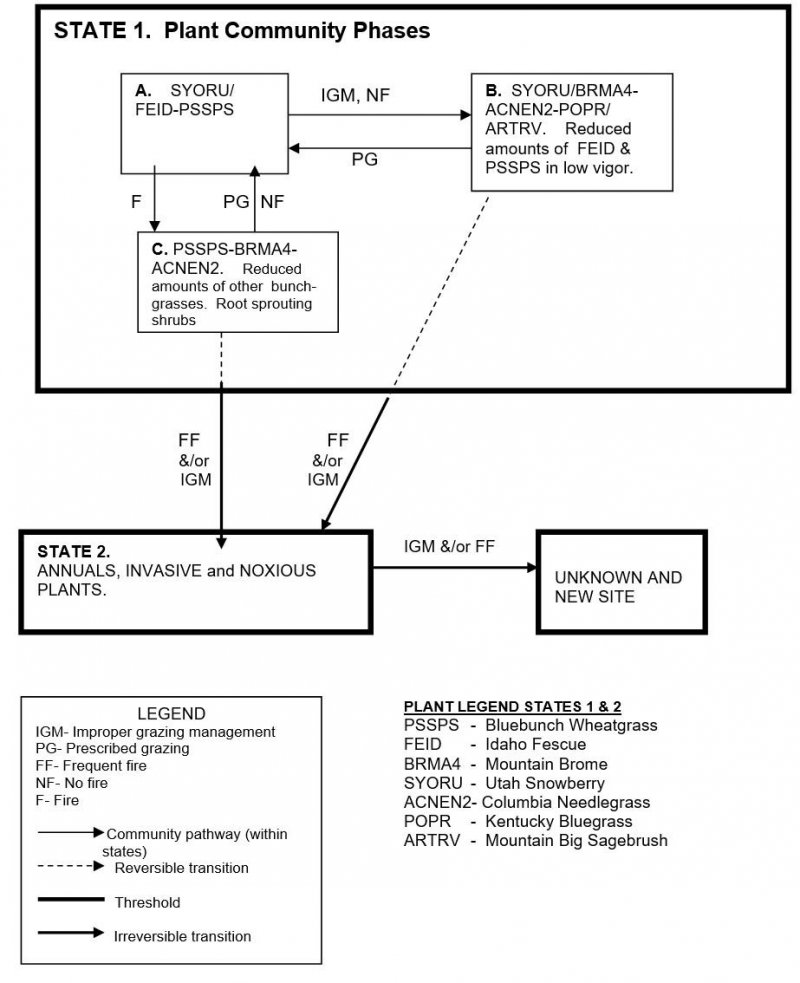
Click on box and path labels to scroll to the respective text.
