Natural Resources
Conservation Service
Ecological site F043CY511WA
Frigid, Dry-Udic, Loamy, Hills, and Canyons, Basalt, Mixed Ash (grand fir/moist herb)
Last updated: 9/08/2023
Accessed: 02/15/2026
General information
Provisional. A provisional ecological site description has undergone quality control and quality assurance review. It contains a working state and transition model and enough information to identify the ecological site.
MLRA notes
Major Land Resource Area (MLRA): 043C–Blue and Seven Devils Mountains
Major land resource area (MLRA): 043C-Blue and Seven Devils Mountains
Description of MLRAs can be found in: United States Department of Agriculture, Natural Resources Conservation Service. 2006. Land Resource Regions and Major Land Resource Areas of the United States, the Caribbean, and the Pacific Basin. U.S. Department of Agriculture Handbook 296.
Available electronically at: http://www.nrcs.usda.gov/wps/portal/nrcs/detail/soils/ref/?cid=nrcs142p2_053624#handbook
LRU notes
Most commonly found in LRU 43C02 (Eastern High Basalt Plateau).
Classification relationships
This ecological site is aligned to the following classification systems:
• U.S. National Vegetation/NatureServe and Washington NHP Classification Matrix:
Plant Association Group* Alliance** Association***
ABGR/CLUN (modal) G-211 A-3362 CEGL 000272
ABGR/TABR/CLUN G-211 A-3362 CEGL 000283
PSME/VAME G-211 A-3362 GEGL 000466
* G-211 is the U.S. National Vegetation Classification (NVC) Standard Middle Rocky Mountain Montane Douglas-fir Forest & Woodland
** Alliance-3462 is the Northern Rocky Mountain Mesic Montane Mixed Conifer Forest
*** CEGL 000272is the Grand fir/Bride’s Bonnet Forest (note that the local name for this plant association is /Queen’s Cup Beadlily (CLUN) Forest
CEGL 000283 is the Grand Fir/Pacific Yew Forest
CEGL 000466 is the Douglas-fir/Thinleaf Huckleberry Forest (note that the local name for this plant association is /Big Huckleberry (VAME) Forest
• USDA Forest Service Ecological Sub-region M332 “Blue Mountains”.
• LANDFIRE BpS model 10470: Northern Rocky Mountain Mesic Montane Mixed-Conifer Forest (primary model).
• Ecoclass Code(s): ABGR/CLUN-CWF421; ABGR/TABR/CLUN-CWC811 and PSME/VAME-CDS821 (All plant associations are in the Blue-Ochoco PA, 1991).
Ecological site concept
The grand fir/cool moist forb (GF -CMF) ecological site (ES) encompasses the modal grand fir (Abies grandis)/queen’s cup beadlily (Clintonia uniflora) plant association (ABGR/CLUN) , and the closely related grand fir/Pacific yew (Taxus brevifolia)/queen’s cup beadlily plant association ABGR/TABR/CLUN). Pacific yew forests are a moist microsite association, with longer fire return intervals compared to queen’s cup beadlily associations. This ecological site occupies the wetter and cooler end of the moisture/temperature spectrum for the grand fir series. It’s found on moist, well-drained sites which are protected from harsh sun and wind. These soils have developed in highly mixed Mazama tephra deposits over residuum and colluvium from basalt or metavolcanics. The soils are very deep and have adequate available water capacity to a depth of 40 inches.
Associated sites
| F043CY503WA |
Frigid, Moist-Xeric Loamy, Canyons and Mountains (Grand fir/Moist Shrub) frigid, moist-xeric, ashy surface, basalt/andesite geology. |
|---|---|
| F043CY504WA |
Warm-Frigid, Xeric, Loamy, Basalt Mountains and Plateaus (Douglas-fir/warm dry shrub) warm-frigid, xeric, mixed ash surface, basalt geology. |
Similar sites
| F043CY501WA |
Mesic, Xeric, Loamy Foothills and Canyons (Ponderosa Pine Warm Dry Shrub) Pinus ponderosa/Symphoricarpos albus ashy surface |
|---|---|
| F043CY512WA |
Frigid, Dry-Udic, Loamy, Hills, and Canyons, Mixed Ash (grand fir/moist herb) geology other than basalt |
| F043CY510WA |
Frigid, Dry-Udic, Loamy, Hills and Mountains, Basalt, Ashy surface (grand fir/moist herb) ashy surface |
Table 1. Dominant plant species
| Tree |
(1) Abies grandis |
|---|---|
| Shrub |
(1) Acer glabrum |
| Herbaceous |
(1) Clintonia uniflora |
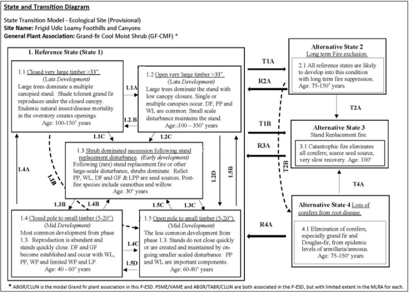
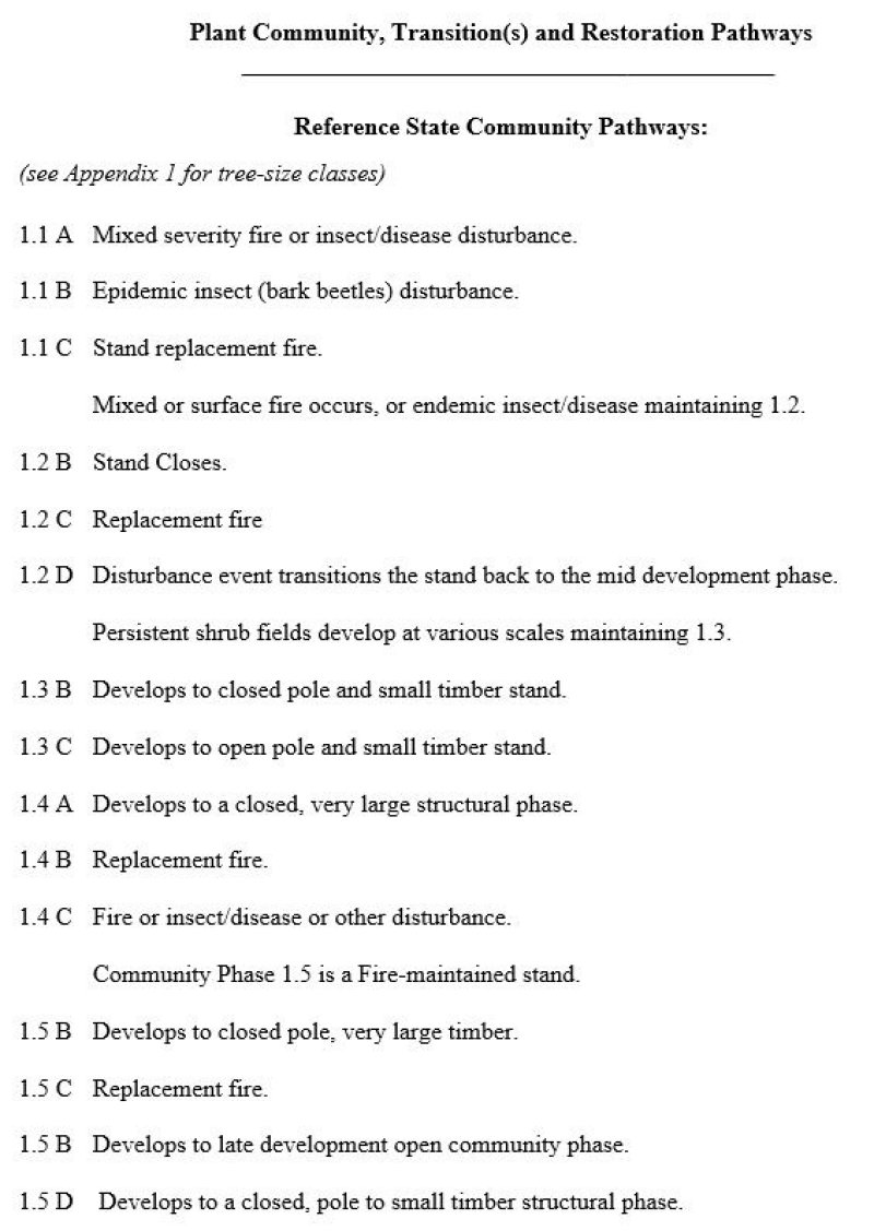
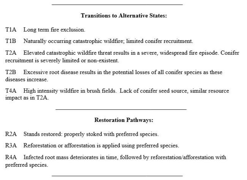
Click on box and path labels to scroll to the respective text.


