Natural Resources
Conservation Service
Ecological site R044AP801MT
Bottomland Group
Last updated: 9/07/2023
Accessed: 02/08/2026
General information
Provisional. A provisional ecological site description has undergone quality control and quality assurance review. It contains a working state and transition model and enough information to identify the ecological site.
MLRA notes
Major Land Resource Area (MLRA): 044A–Northern Rocky Mountain Valleys
Major Land Resource Area (MLRA): 044A–Northern Rocky Mountain Valleys
This MLRA includes the northern portion of the Northern Rocky Mountain Valleys Province of the Rocky Mountain System. The mountain valleys are deeply dissected and are typically bordered by mountains trending north to south. The nearly level broad flood plains are bordered by gently to strongly sloping terraces and alluvial fans. The surrounding mountains and in some areas the valleys experienced glaciation. The average precipitation is 12 to 16 inches generally, though can vary widely. The dominant soil orders are Inceptisols, Mollisols and Andisols. The valleys support coniferous forests, shrublands and grasslands.
Description of MLRAs can be found in: United States Department of Agriculture, Natural Resources Conservation Service. 2006. Land Resource Regions and Major Land Resource Areas of the United States, the Caribbean, and the Pacific Basin. U.S. Department of Agriculture Handbook 296.
Available electronically at: http://www.nrcs.usda.gov/wps/portal/nrcs/detail/soils/ref/?cid=nrcs142p2_053624#handbook
Ecological site concept
• Site does receive any additional water
• Site located in a flood plain
• Dominant Cover: Grassland, Shrubland, Deciduous Woodland
• Soils are
o Generally not saline or saline-sodic or limy (limited extent)
o Moderately deep, deep or very deep
o Not ashy or medial textural family
o Typically less than 15% stone and boulder surface area (<15% max)
• Soil surface texture fine sandy loam to sandy loam, silty loam in surface mineral 4”
• Parent material is alluvium, lacustrine deposits
• Drainage class is very poorly to excessively well drained; rare to frequent flooding frequency
• Site Landform: drainageways, flood plains, abandoned channels on flood plains
• Moisture Regime: aquic
• Temperature Regime: frigid
• Elevation Range: 3100-3800 ft
• Slope: 0-2%
Associated sites
| R044AP806MT |
Subirrigated Grassland Group This associated ecological site resides in areas with subirrigated hydrology in areas adjacent to this ecological site. |
|---|
Similar sites
| R044AP806MT |
Subirrigated Grassland Group This ecological site is similar to this ecological site in that it receives additional subirrigated water but different in geography that it resides in a floodplain as opposed to an upland site. |
|---|
Table 1. Dominant plant species
| Tree |
(1) Populus balsamifera ssp. trichocarpa |
|---|---|
| Shrub |
(1) Cornus sericea ssp. sericea |
| Herbaceous |
(1) Deschampsia cespitosa |
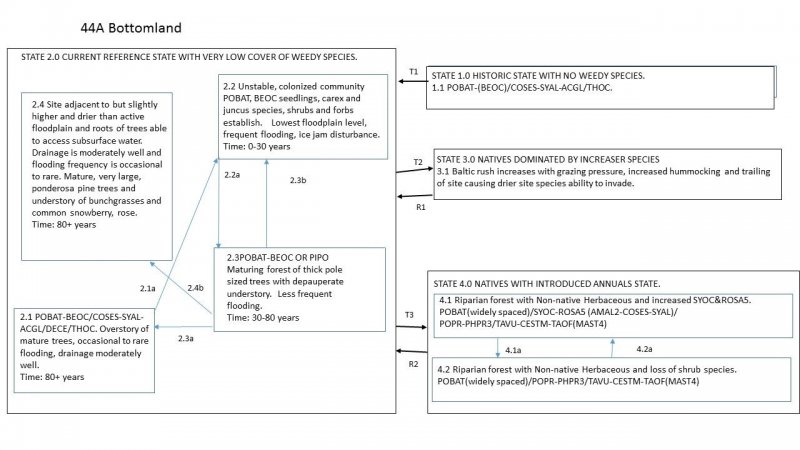
Click on box and path labels to scroll to the respective text.

