Ecological dynamics
Ecological Dynamics of the Site
It is impossible to determine in any quantitative detail the Historic Climax Plant Community (HCPC) for this ecological site because of the lack of direct historical documentation preceding all human influence. In the 1860s, Europeans brought cattle and horses to the area, grazing large numbers of them on unfenced parcels year-long. Itinerant and local sheep flocks followed, largely replacing cattle as the browse component increased.
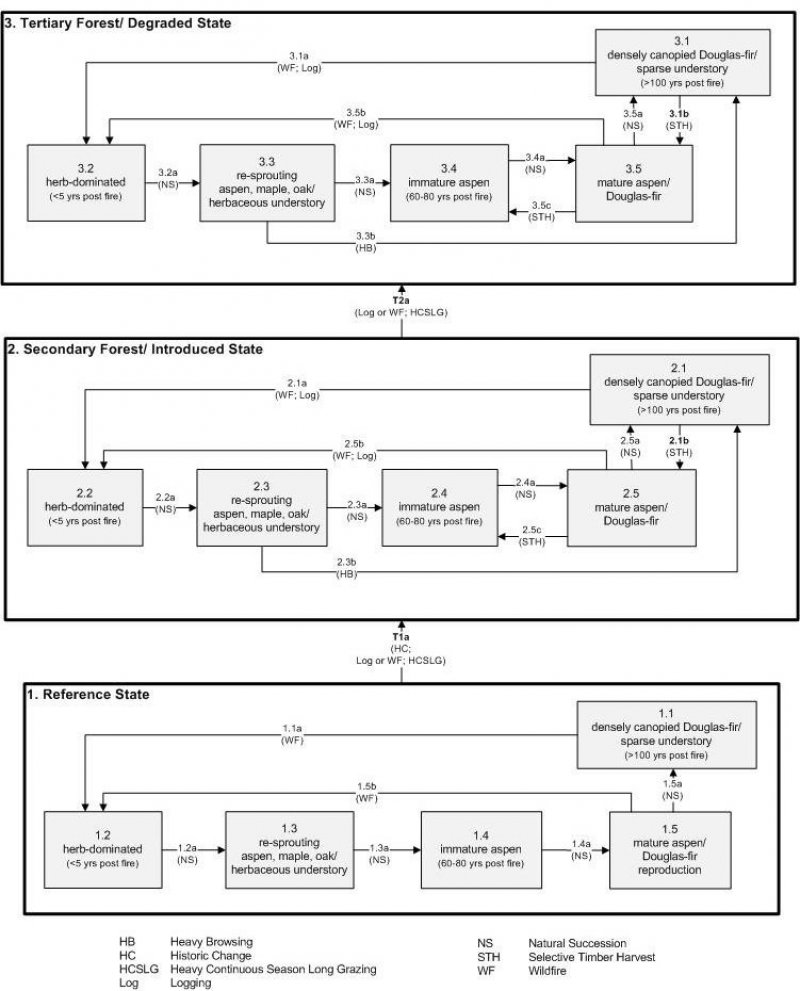
Below is a state-and-transition model diagram that illustrates the “phases” (common plant communities), and “states” (aggregations of those plant communities) that can occur on the site. Differences between phases and states depend primarily upon observations of a range of disturbance histories in areas where this ESD is represented. These situations include grazing gradients to water sources, fence-line contrasts, patches with differing dates of fire, herbicide treatment, tillage, and kinds and times of timber harvest, etc. Reference State 1 illustrates the common plant communities that probably existed just prior to European settlement.
The major successional pathways within states, (“community pathways”) are indicated by arrows between phases. “Transitions” are indicated by arrows between states. The drivers of these changes are indicated in codes decipherable by referring to the legend at the bottom of the page and by reading the detailed narratives that follow the diagram. The transition between Reference State 1 and State 2 is considered irreversible because of the naturalization of exotic species of both flora and fauna, possible extinction of native species, and climate change. There may have also been accelerated soil erosion.
When available, monitoring data (of various types) were employed to validate more subjective inferences made in this diagram. See the complete files in the office of the State Range Conservationist for more details.
The plant communities shown in this state-and-transition model may not represent every possibility, but are probably the most prevalent and recurring plant communities. As more monitoring data are collected, some phases or states may be revised, removed, and new ones may be added. None of these plant communities should necessarily be thought of as “Desired Plant Communities.” According to the USDA NRCS National Range & Pasture Handbook (USDA-NRCS 2003), Desired Plant Communities (DPC’s) will be determined by the decision-makers and will meet minimum quality criteria established by the NRCS. The main purpose for including descriptions of a plant community is to capture the current knowledge at the time of this revision.
Community 1.1
Reference State
The Reference State is a description of this ecological site just prior to Euro-American settlement but long after the arrival of Native Americans. At the time of European colonization, what would have been observed on these sites depended primarily on the time since the last wildfire occurred. If the site had not experienced fire for about 100 years, Douglas-fir (Pseudotsuga menziesii) would have been the dominant species occupying the site with a sparse understory (1.1) due to tree competition, overstory shading, and duff accumulation. Douglas-fir replaces itself without wildfire and would have been the climax dominant. Wildfire (1.1a) would have replaced these stands with a rich herb-dominated vegetation (1.2). In the absence of any major disturbance (1.2a, 1.3a, 1.4a, 1.5a), the re-sprouting vegetation including quaking aspen (Populus tremuloides), bigtooth maple (Acer grandidentatum), and Gambel oak (Quercus gambelii) would have reclaimed the site (1.3), followed by the increasing presence of aspen (Populus tremuloides), first as saplings (1.4), and later as mature aspen with Douglas-fir seedlings (1.5), ultimately to where aspen would have been outcompeted by Douglas-fir returning to the climax vegetation (1.1). A more complete list of species by lifeform for the Reference State is available in accompanying tables in the “Plant Community Composition by Weight and Percentage” section of this document. Wildfire (1.1a, 1.5b) would have been the primary disturbance factor prior to colonization.
Community Phase 1.1: densely canopied Douglas-fir/sparse understory
This plant community (1.1) would have been characterized by a stand of mature Douglas-fir with a sparse understory of Geyer’s sedge (Carex geyeri), bluegrass (Poa spp.), chokecherry (Prunus virginiana), Fendler’s meadow-rue (Thalictrum fendleri), and creeping barberry (Mahonia repens).
Community Pathway 1.1a:
Wildfire would have removed the trees, allowing shade-intolerant herbs to flourish briefly.
Community Phase 1.2: herb-dominated
This plant community would have developed within the first 5 years since the last fire, with Geyer’s sedge, bluegrass, slender wheatgrass (Elymus trachycaulus), heartleaf arnica (Arnica cordifolia) and feathery false lily of the valley (Maianthemum racemosum ssp. racemosum) being the dominant understory species.
Community Pathway 1.2a:
After about 5 years, shrubs begin to establish.
Community Phase 1.3: re-sprouting aspen, maple, oak/herbaceous understory
For a period of about 5 to 60 years post fire, a mixture of re-sprouting shrubs would have been dominant on the site, including, quaking aspen, bigtooth maple, and Gambel oak. Other prominent shrubs would have been mountain snowberry (Symphoricarpos oreophilus), chokecherry (Prunus virginiana), Saskatoon serviceberry (Amelanchier alnifolia), and Oregon boxleaf (Paxistima myrsinites), among others. The herbaceous understory would also have been fairly intact.
Community Pathway 1.3a:
About 60 years after fire, aspen would become established in the site.
Community Phase 1.4: immature aspen
This plant community would have been dominated by a stand of immature aspen, which is a seral species while Douglas-fir begins to establish itself under other nurse species. A stand of immature aspen would have existed approximately 60 to 80 years since last fire.
Community Pathway 1.4a:
Aspen would have continued to mature while Douglas-fir would have become well established in the understory.
Community Phase 1.5: mature aspen/ Douglas-fir
A stand of mature aspen intermixed with Douglas-fir saplings would have been encountered approximately 80 to 100 years post fire.
Community Pathway 1.5a:
After about 100 years following the last fire, Douglas-fir would become mature, shading out aspen and the shade-intolerant shrub and herb species in the understory.
Community Pathway 1.5b:
Wildfire would have removed the trees, allowing shade-intolerant herbs to flourish briefly.
Transition T1a: from State 1 to State 2 (Reference State to Secondary Forest/ Introduced State)
The simultaneous introduction of exotic species, both plants and animals, and possible extinctions of native flora and fauna, along with climate change, has caused State 1 to transition to State 2. Europeans further altered this vegetation largely through logging, livestock grazing, trapping of fur beaver and changing the fire regime. Continued impacts could prevent the recovery toward potential conifer dominance (State 2, various phases). The reversal of these changes (i.e. a return pathway) back to State 1 is not practical.
State 2
Secondary Forest/ Introduced State
Community 2.2
Secondary Forest/ Introduced State
State 2 is similar to State 1 in form and function, with the exception of the presence of non-native plants and animals, possible extinctions of native species, a different climate, and a secondary stand of trees. State 2 is a description of the ecological site shortly following Euro-American settlement. This state can be regarded as the current potential. With the least amount of disturbance or manipulation of fire regime (Alexander 1985; 1988), a mature stand of Douglas-fir with a sparse understory component is expected at this site (2.1). As with the Reference State, time since last wildfire remains the key factor in determining what vegetation would be encountered here. Wildfire, particularly crown fires, or complete harvesting of the forest (2.1b, 2.5b) will replace these stands with a rich herb-dominated vegetation. (2.2). In the absence of any major disturbance (2.2a, 2.3a, 2.4a, 2.5a), the vegetation will progress into more of a shrub-herb co-dominance (2.3), followed by the increasing presence of aspen first as saplings (2.4), and later as mature aspen with Douglas-fir (2.5), ultimately to where Douglas-fir will outcompete aspen returning to the climax vegetation (2.1). Because soils on this site are rocky they are considered “self-armoring,” thus making the site resistant to the effects of erosion. Heavy livestock grazing and tree harvests will reduce the stability of this site, while a reduction in livestock use and tree harvests will maintain stability.
Community Phase 2.1: densely canopied Douglas-fir/ sparse understory
This plant community (2.1) is characterized by a stand of mature Douglas-fir with a sparse understory of Geyer’s sedge, and bluegrass may be present.
Community Pathway 2.1a:
A stand-replacing wildfire or intensive logging will set the vegetation back to an early seral herb-dominated phase. Logging opens up the forest canopy allowing more understory for 20 to 30 years.
Community Pathway 2.1b:
The removal of only the mature Douglas-fir will allow some aspen to return and the immature Douglas-fir to continue growing.
Community Phase 2.2: herb-dominated
This plant community will develop within the first 5 years since the last fire. Dominant grasses are Geyer’s sedge, bluegrass, and slender wheatgrass with heartleaf arnica and feathery false lily of the valley as common forbs. A small component of introduced species may also be present.
Community Pathway 2.2a:
The combination of heavy season long livestock grazing and fire exclusion will accelerate woody plant (shrub) establishment and diminish the herbaceous understory.
Community Phase 2.3: re-sprouting aspen, maple, oak/ herbaceous understory
A plant community co-dominated by shrubs and herbs will develop approximately 5 to 60 years post fire. A small component of introduced species may be present.
Community Pathway 2.3a:
The combination of heavy season long livestock grazing and fire exclusion will accelerate woody plant establishment and diminish the herbaceous understory.
Community Pathway 2.3b:
Heavy browsing will lead to Phase 2.1, a densely canopied Douglas-fir community with a sparse understory.
Community Phase 2.4: immature aspen
Aspen will establish in the site 60 to 80 years after the last fire or complete tree removal.
Community Pathway 2.4a:
The combination of heavy season long livestock grazing and fire exclusion will accelerate woody plant establishment and diminish the understory.
Community Phase 2.5: mature aspen/ Douglas-fir
A stand of mature aspen intermixed with Douglas-fir will develop approximately 80 to 100 years following fire or complete tree removal.
Community Pathway 2.5a:
The combination of heavy season long livestock grazing and fire exclusion will accelerate woody plant establishment and diminish the understory.
Community Pathway 2.5b:
A stand-replacing wildfire or intensive logging will set the vegetation back to an early seral herb-dominated phase. Logging opens up the forest canopy allowing more understory for 20 to 30 years.
Community Pathway 2.5c:
The removal of mature aspen will leave a stand of immature aspen, possibly with a few Douglas-fir in the understory.
Transition T2a: from State 2 to State 3 (Secondary Forest/ Introduced State to Tertiary Forest/ Degraded State)
The Secondary Forest/ Introduced State will transition to the Tertiary Forest/ Degraded State following a second cycle of timber harvest or stand replacing wildfire, and further impacts from heavy continuous season-long grazing. Logging opens up the forest canopy allowing shade tolerant understory for 20 to 30 years. Secondary and tertiary disturbances produce an assemblage of vegetation from degraded temporary meadows to further simplified forests. A key indicator of the approach to this transition the presence of dominant trees that have reached the size required for commercial harvest. The trigger is a management decision. The second cycle of cutting typically is a clear-cut, where all stems are downed, slash piled and burned.
State 3
Tertiary Forest/ Degraded State
State 3 is characterized by tertiary forests that are further degraded in both understory and remnant tree layers. Active fire suppression speeds up the recovery of dominance by woody plants. Less predictable changes in the vegetation of State 3 will ensue due to global climate changes.
Community Phase 3.1: densely canopied Douglas-fir/ sparse understory
This plant community (3.1) is characterized by a stand of mature Douglas-fir. A sparse understory of Geyer’s sedge and bluegrass may be present.
Community Pathway 3.1a:
A stand-replacing wildfire or intensive logging will set the vegetation back to an early seral herb-dominated phase. Logging opens up the forest canopy, allowing shade-intolerant grasses, forbs, and shrubs to flourish for 20 to 30 years.
Community Pathway 3.1b:
The removal of only the mature Douglas-fir will allow aspen to return and the immature Douglas-fir to continue growing.
Community Phase 3.2: herb-dominated
This plant community will develop within the first 5 years since the last fire. Dominant grasses are Geyer’s sedge, bluegrass, and slender wheatgrass. A small component of introduced species may be present.
Community Pathway 3.2a:
After about 5 years, shrubs will begin to establish in the site.
Community Phase 3.3: re-sprouting aspen, maple, oak/ herbaceous understory
A plant community co-dominated by shrubs and herbs will develop approximately 5 to 60 years after fire or complete tree removal. A small component of introduced species may be present.
Community Pathway 3.3a:
Aspen will become established at the site after 60-80 years following the last wildfire or complete tree removal.
Community Phase 3.4: immature aspen
Immature aspen dominate the stand 60 to 80 years following the last fire or complete tree removal.
Community Pathway 3.4a:
Aspen matures and immature Douglas-fir become well established in the understory 80 years after the last fire or complete tree removal.
Community Phase 3.5: mature aspen/ Douglas-fir
A stand of mature aspen intermixed with Douglas-fir will develop approximately 80 to 100 years after the last fire or complete tree removal.
Community Pathway 3.5a:
After about 100 years following the last fire, Douglas-fir will become mature, shading out aspen and the shade-intolerant shrub and herb species in the understory.
Community Pathway 3.5b:
A stand-replacing wildfire or intensive logging will set the vegetation back to an early seral herb-dominated phase clear-cut. Logging opens up the forest canopy allowing more understory for 20 to 30 years.
Community Pathway 3.5c:
The removal of mature aspen will leave a stand of immature aspen, possibly with a few Douglas-fir in the understory.