Natural Resources
Conservation Service
Ecological site F047XC405UT
Mountain Cobbly Sandy Loam (ponderosa pine)
Last updated: 2/05/2025
Accessed: 04/03/2026
General information
Provisional. A provisional ecological site description has undergone quality control and quality assurance review. It contains a working state and transition model and enough information to identify the ecological site.
MLRA notes
Major Land Resource Area (MLRA): 047X–Wasatch and Uinta Mountains
MLRA 47 occurs in Utah (86 percent), Wyoming (8 percent), Colorado (4 percent), and Idaho (2 percent). It encompasses approximately 23,825 square miles (61,740 square kilometers). The MLRA includes the Uinta Mountains, which trend east and west. The Uinta Mountains have a broad, gently arching, elongated shape. Structurally, they consist of a broadly folded anticline that has an erosion-resistant quartzite core. The Wasatch and Uinta Mountains have an elevation of 4,900 to about 13,500 feet (1,495 to 4,115 meters).
The mountains in this area are primarily fault blocks that have been tilted up. Alluvial fans at the base of the mountains are recharge zones for the basin fill aquifers. Rocks exposed in the Uinta mountains are Precambrian. The Uinta Mountains are one of the few ranges in the United States that are oriented west to east.
The average precipitation can range up to 73 inches (1854 mm) in the mountains. The Uinta mountains have a greater incidence of high-intensity summer thunderstorms; hence, a significant amount of precipitation occurs during the summer months. The average annual temperature is 30 to 50 degrees Fahrenheit (-1 to 15 C). The freeze-free period averages 140 days and ranges from 60 to 220 days, generally decreasing in length with elevation.
The dominant soil orders in this MLRA are Entisols, Inceptisols, and Mollisols. The lower elevations are dominated by a frigid temperature regime, while the higher elevations experience cryic temperature regimes. The soil moisture regime is typically ustic. The minerology is generally mixed and the soils are very shallow to very deep, generally well drained, and loamy, sandy or sandy–skeletal.
Ecological site concept
The soils of this site formed mostly in colluvium and slope alluvium derived from various parent materials including metamorphic and sedimentary rock. Surface soils are very cobbly fine sandy loam in texture. Rock fragments are evident throughout the profile, but make up less than 60 percent of the soil volume. These soils are very deep, well-drained to excessively drained. The pH is neutral to slightly alkaline. Available water-holding capacity ranges from 1.2 to 4.7 inches of water in the upper 40 inches of soil. The soil moisture regime is ustic and the soil temperature regime is frigid.
Associated sites
| R047XC462UT |
Mountain Stony Loam (mountain big sagebrush) Sites often occur adjacent to each other. |
|---|
Similar sites
| R047XC453UT |
Mountain Shallow Sandy Loam (ponderosa pine) Site has similar floristic characteristics but is shallower. |
|---|
Table 1. Dominant plant species
| Tree |
(1) Pinus ponderosa |
|---|---|
| Shrub |
(1) Arctostaphylos patula |
| Herbaceous |
(1) Festuca occidentalis |
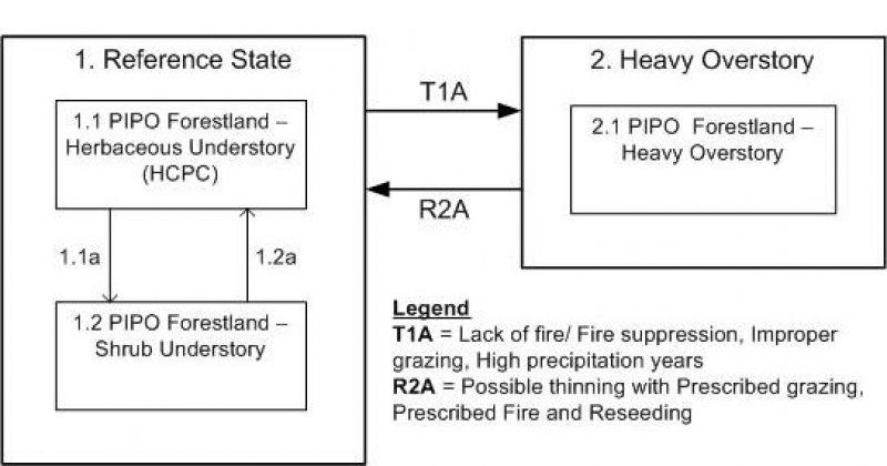
Click on box and path labels to scroll to the respective text.