Natural Resources
Conservation Service
Ecological site F047XC458UT
Mountain Stony Loam (quaking aspen thicket)
Last updated: 2/05/2025
Accessed: 04/03/2026
General information
Provisional. A provisional ecological site description has undergone quality control and quality assurance review. It contains a working state and transition model and enough information to identify the ecological site.
MLRA notes
Major Land Resource Area (MLRA): 047X–Wasatch and Uinta Mountains
MLRA 47 occurs in Utah (86 percent), Wyoming (8 percent), Colorado (4 percent), and Idaho (2 percent). It encompasses approximately 23,825 square miles (61,740 square kilometers). The MLRA includes the Uinta Mountains, which trend east and west. The Uinta Mountains have a broad, gently arching, elongated shape. Structurally, they consist of a broadly folded anticline that has an erosion-resistant quartzite core. The Wasatch and Uinta Mountains have an elevation of 4,900 to about 13,500 feet (1,495 to 4,115 meters).
The mountains in this area are primarily fault blocks that have been tilted up. Alluvial fans at the base of the mountains are recharge zones for the basin fill aquifers. Rocks exposed in the Uinta mountains are Precambrian. The Uinta Mountains are one of the few ranges in the United States that are oriented west to east.
The average precipitation can range up to 73 inches (1854 mm) in the mountains. The Uinta mountains have a greater incidence of high-intensity summer thunderstorms; hence, a significant amount of precipitation occurs during the summer months. The average annual temperature is 30 to 50 degrees Fahrenheit (-1 to 15 C). The freeze-free period averages 140 days and ranges from 60 to 220 days, generally decreasing in length with elevation.
The dominant soil orders in this MLRA are Entisols, Inceptisols, and Mollisols.
LRU notes
This LRU is the Uinta Mountains portion of MLRA 47 that run east and west which includes the Uinta Wilderness and The Flaming Gorge National Recreation Area and towns such as Evanston, Wyoming, Hanna and Tabiona, Utah. Structurally these mountains consist of a broadly folded anticline that has an erosion resistance quartzite core. The Duchesne River and many other tributaries to the Green River run through this range, as well as the headwaters of the Bear River. The lower elevations are dominated by a frigid temperature regime, while the higher elevations experience cryic temperature regimes. The soil moisture regime is typically ustic. The minerology is generally mixed and the soils are very shallow to very deep, generally well drained, and loamy, sandy or sandy skeletal.
Ecological site concept
This site is represented by a small pocket of weaker/lower growing Aspen. The site resembles 47A 458 site except for a greater composition of warm-season plant species within the reference community.
The soils of this site formed in slope alluvium over outwash derived from metamorphic and sedimentary rock on outwash fans. Surface soils are very cobbly fine sandy loams in texture. Rock fragments may be present on the soil surface and throughout the profile, but make up less than 35 percent of the soil volume. These soils are deep to very deep, well-drained, and have moderately slow to moderately rapid permeability. pH is slightly acidic to neutral. Available water-holding capacity ranges from 1.3 to 2.8 inches of water in the upper 60 inches of soil. The soil moisture regime is mostly ustic and the soil temperature regime can be frigid. Elevations typically range from 7,600 to 8,500 feet with precipitation ranging from 16 to 22 inches.
Associated sites
| R047XC462UT |
Mountain Stony Loam (mountain big sagebrush) Sites often occur adjacent to each other. |
|---|
Similar sites
| F047XC508UT |
High Mountain Loam (quaking aspen) Sites have similar floristic characteristics, however this site has deeper soils and is generally a larger stand compared to the aspen thicket. |
|---|
Table 1. Dominant plant species
| Tree |
(1) Populus tremuloides |
|---|---|
| Shrub |
Not specified |
| Herbaceous |
Not specified |
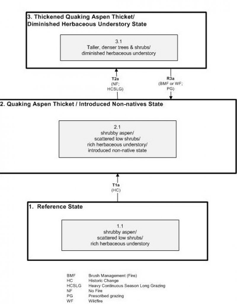
Click on box and path labels to scroll to the respective text.
Ecosystem states
| T1 | - | introduction of exotic species |
|---|---|---|
| T2 | - | The lack of fire and continued season-long grazing |
| R3 | - | With prescribed or wildfire, followed by a reduction in livestock grazing levels |