Natural Resources
Conservation Service
Ecological site R047XB220UT
Semidesert Loam (basin big sagebrush)
Last updated: 2/06/2025
Accessed: 04/03/2026
General information
Provisional. A provisional ecological site description has undergone quality control and quality assurance review. It contains a working state and transition model and enough information to identify the ecological site.
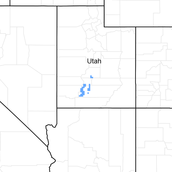
Figure 1. Mapped extent
Areas shown in blue indicate the maximum mapped extent of this ecological site. Other ecological sites likely occur within the highlighted areas. It is also possible for this ecological site to occur outside of highlighted areas if detailed soil survey has not been completed or recently updated.
MLRA notes
Major Land Resource Area (MLRA): 047X–Wasatch and Uinta Mountains
MLRA 47 occurs in Utah (86 percent), Wyoming (8 percent), Colorado (4 percent), and Idaho (2 percent). It encompasses approximately 23,825 square miles (61,740 square kilometers). The northern half of this area is in the Middle Rocky Mountains Province of the Rocky Mountain System. The southern half is in the High Plateaus of the Utah Section of the Colorado Plateaus Province of the Intermontane Plateaus. Parts of the western edge of this MLRA are in the Great Basin Section of the Basin and Range Province of the Intermontane Plateaus. The MLRA includes the Wasatch Mountains, which trend north and south, and the Uinta Mountains, which trend east and west. The steeply sloping, precipitous Wasatch Mountains have narrow crests and deep valleys. Active faulting and erosion are a dominant force in controlling the geomorphology of the area. The Uinta Mountains have a broad, gently arching, elongated shape. Structurally, they consist of a broadly folded anticline that has an erosion-resistant quartzite core. The Wasatch and Uinta Mountains have an elevation of 4,900 to about 13,500 feet (1,495 to 4,115 meters).
The mountains in this area are primarily fault blocks that have been tilted up. Alluvial fans at the base of the mountains are recharge zones for the basin fill aquifers. An ancient shoreline of historic Bonneville Lake is evident on the footslopes along the western edge of the area. Rocks exposed in the mountains are mostly Mesozoic and Paleozoic sediments, but Precambrian rocks are exposed in the Uinta Mountains. The Uinta Mountains are one of the few ranges in the United States that are oriented west to east. The southern Wasatch Mountains consist of Tertiary volcanic rocks occurring as extrusive lava and intrusive crystalline rocks.
The average precipitation is from 8 to 16 inches (203 to 406 mm) in the valleys and can range up to 73 inches (1854 mm) in the mountains. In the northern and western portions of the MLRA, peak precipitation occurs in the winter months. The southern and eastern portions have a greater incidence of high-intensity summer thunderstorms; hence, a significant amount of precipitation occurs during the summer months. The average annual temperature is 30 to 50 degrees Fahrenheit (-1 to 15 C). The freeze-free period averages 140 days and ranges from 60 to 220 days, generally decreasing in length with elevation.
The dominant soil orders in this MLRA are Aridisols, Entisols, Inceptisols, and Mollisols. The lower elevations are dominated by a frigid temperature regime, while the higher elevations experience cryic temperature regimes. Mesic temperature regimes come in on the lower elevations and south facing slopes in the southern portion of this MLRA. The soil moisture regime is typically xeric in the northern part of the MLRA, but grades to ustic in the extreme eastern and southern parts. The mineralogy is generally mixed and the soils are very shallow to very deep, generally well drained, and loamy or loamy-skeletal.
LRU notes
E47B is the Wasatch Mountains South MLRA. It occurs in the Loa, Panguitch, New Harmony area. Most of Zion, Bryce Canyon National Parks and Cedar Breaks National Monument are in this area. This area is composed of mountain ranges that run north and south.
Classification relationships
Modal Soil: Alldown CL — fine-loamy, mixed (calcareous), frigid Ustic Torriorthent
Ecological site concept
The soils of this site formed mostly in alluvium from igneous and sedimentary rock. Surface soils are loam and clay loam in texture. Rock fragments may be present on the soil surface and throughout the profile, but make up less than 35 percent of the soil volume. These soils are deep to very deep, well-drained, and have moderate to moderately slow permeability. pH is slightly to moderately alkaline. Available water-holding capacity ranges from 6.0 to 8.0 inches of water in the upper 60 inches of soil. The soil moisture regime is mostly ustic and the soil temperature regime is frigid. Precipitation ranges from 8 to 12 inches annually.
Associated sites
| R047XB210UT |
Semidesert Gravelly Loam (black sagebrush) |
|---|
Similar sites
| R047XB222UT |
Semidesert Loam (Wyoming big sagebrush) |
|---|
Table 1. Dominant plant species
| Tree |
Not specified |
|---|---|
| Shrub |
(1) Artemisia tridentata ssp. tridentata |
| Herbaceous |
(1) Pascopyrum smithii |
Physiographic features
This site occurs on dissected alluvial fans and valley flats.
Table 2. Representative physiographic features
| Landforms |
(1)
Alluvial fan
(2) Valley flat |
|---|---|
| Runoff class | Low to medium |
| Flooding frequency | None |
| Ponding frequency | None |
| Elevation | 6,500 – 7,200 ft |
| Slope | 8% |
| Aspect | Aspect is not a significant factor |
Climatic features
The climate is characterized by cold, snowy winters and cool, moist summers. Approximately 50 percent of the moisture comes during the plant growth period from April 1 through September 30. On the average April, May, and June are the driest months and July, August, and September are the wettest months.
Table 3. Representative climatic features
| Frost-free period (average) | 90 days |
|---|---|
| Freeze-free period (average) | 100 days |
| Precipitation total (average) | 10 in |
Influencing water features
Due to its landscape position, this site is not influenced by streams or wetlands.
Wetland description
N/A
Soil features
The soils of this site formed mostly in alluvium from igneous and sedimentary rock. Surface soils are loam and clay loam in texture. Rock fragments may be present on the soil surface and throughout the profile, but make up less than 35 percent of the soil volume. These soils are deep to very deep, well-drained, and have moderate to moderately slow permeability. pH is slightly to moderately alkaline. Available water-holding capacity ranges from 6.0 to 8.0 inches of water in the upper 60 inches of soil. Average annual soil loss in potential is approximately 5 tons per acre. The soil moisture regime is mostly ustic and the soil temperature regime is frigid. Precipitation ranges from 8 to 12 inches annually.
Table 4. Representative soil features
| Parent material |
(1)
Alluvium
–
igneous and sedimentary rock
|
|---|---|
| Surface texture |
(1) Loam (2) Clay loam |
| Drainage class | Well drained |
| Permeability class | Moderately slow to moderate |
| Depth to restrictive layer | 60 in |
| Soil depth | 60 in |
| Surface fragment cover <=3" | 10% |
| Surface fragment cover >3" | Not specified |
| Available water capacity (Depth not specified) |
6 – 8 in |
| Calcium carbonate equivalent (Depth not specified) |
30% |
| Electrical conductivity (Depth not specified) |
2 mmhos/cm |
| Sodium adsorption ratio (Depth not specified) |
Not specified |
| Soil reaction (1:1 water) (Depth not specified) |
7.4 – 8.4 |
| Subsurface fragment volume <=3" (Depth not specified) |
15% |
| Subsurface fragment volume >3" (Depth not specified) |
10% |
Ecological dynamics
As ecological condition deteriorates due to overgrazing, grasses decrease while basin big sagebrush and rubber rabbitbrush increase. When the potential natural plant community is burned, basing big sagebrush decreases while grasses increase. Cheatgrass and Russian thistle are most likely to invade this site.
Ecological Dynamics of the Site
It is impossible to determine in any quantitative detail the Historic Climax Plant Community (HCPC) for this ecological site because of the lack of direct historical documentation preceding all human influence. In some areas, the earliest reports of dominant plants include the cadastral survey conducted by the General Land Office, which began in the late 19th century for this area (Galatowitsch 1990). However, up to the 1870s the Shoshone Indians, prevalent in northern Utah and neighboring states, grazed horses and set fires to alter the vegetation for their needs (Parson 1996). In the 1860s, Europeans brought cattle and horses to the area, grazing large numbers of them on unfenced parcels year-long (Parson 1996). Itinerant and local sheep followed, largely replacing cattle as the browse component increased.
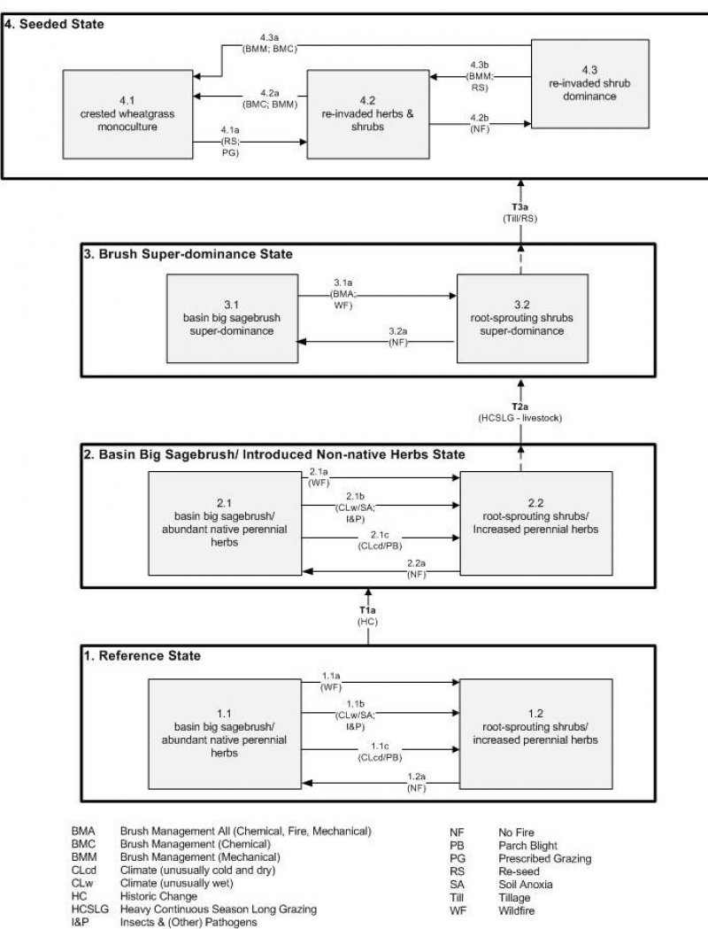
Below is a State and Transition Model diagram to illustrate the “phases” (common plant communities), and “states” (aggregations of those plant communities) that can occur on the site. Differences between phases and states depend primarily upon observations of a range of disturbance histories in areas where this ESD is represented. These situations include grazing gradients to water sources, fence-line contrasts, patches with differing dates of fire, herbicide treatment, tillage, etc. Reference State 1 illustrates the common plant communities that probably existed just prior to European settlement.
The major successional pathways within states, (“community pathways”) are indicated by arrows between phases. “Transitions” are indicated by arrows between states. The drivers of these changes are indicated in codes decipherable by referring to the legend at the bottom of the page and by reading the detailed narratives that follow the diagram. The transition between Reference State 1 and State 2 is considered irreversible because of the naturalization of exotic species of both flora and fauna, possible extinction of native species, and climate change. There may have also been accelerated soil erosion.
When available, monitoring data (of various types) were employed to validate more subjective inferences made in this diagram. See the complete files in the office of the State Range Conservationist for more details.
The plant communities shown in this State and Transition Model may not represent every possibility, but are probably the most prevalent and recurring plant communities. As more monitoring data are collected, some phases or states may be revised, removed, or new ones may be added. None of these plant communities should necessarily be thought of as “Desired Plant Communities.” According to the USDA NRCS National Range and Pasture Handbook (USDA-NRCS 2003), Desired Plant Communities (DPC’s) will be determined by the decision-makers and will meet minimum quality criteria established by the NRCS. The main purpose for including descriptions of a plant community is to capture the current knowledge at the time of this revision.
State 1: Reference State
The Reference State is a description of this ecological site just prior to Euro-American settlement but long after the arrival of Native Americans. The description of the Reference State was determined by NRCS Soil Survey Type Site Location information and familiarity with rangeland relict areas where they exist. The Reference State for this site would have been characterized as a shrub steppe co-dominated by basin big sagebrush (Artemisia tridentata ssp. tridentata), the dominant shrub, and having a rich herbaceous understory. The proportions of shrubs and herbs would have been dependent upon the length of time elapsed since the last wildfire or other sagebrush-killing event. If fire had not occurred within the past 30 years (1.2a), basin big sagebrush would have been the dominant shrub, having a native perennial herbaceous understory (1.1). If less than 10 years had elapsed since the last fire (1.1a), perennial native herbs would have increased and the shrub component would have been dominated by root-sprouting species such as rubber rabbitbrush (Ericameria nauseosa), yellow rabbitbrush (Chrysothamnus viscidiflorus) and spineless horsebrush (Tetradymia canescens) (1.2). Soil anoxia from extremely wet years or an outbreak of Aroga (Aroga spp.) moth (1.1b) could have also reduced sagebrush and enhanced root-sprouting shrubs and perennial herbs (1.2) in some years. The same effect would have also been achieved by parch blight due to lack of snow cover during dry, cold winters (1.1c). A more complete list of species by lifeform for the Reference State is available in the accompanying tables in the “Plant Community Composition by Weight and Percentage” section of this document.
Community Phase 1.1: Basin big sagebrush/ abundant native perennial herbs
This plant community would have developed in the absence of recent fire and was characterized by basin big sagebrush and abundant native perennial herbs. Primary bunchgrasses would have included bluebunch wheatgrass (Pseudoroegneria spicata), needle-and-thread (Hesperostipa comata), Indian ricegrass (Achnatherum hymenoides), and basin wildrye (Leymus cinereus). Primary forbs would have included buckwheat (Eriogonum spp.), tapertip hawksbeard (Crepis acuminata), arrowleaf balsamroot (Balsamorhiza sagittata), western stoneseed (Lithospermum ruderale), and longleaf phlox (Phlox longifolia).
Community Pathway 1.1a
Wildfire would have removed basin big sagebrush, allowing root-sprouting shrubs and the native perennial forbs and grasses to increase.
Community Pathway 1.1b
An extremely wet period such as an El Nino-Southern Oscillation event and subsequent anoxious soil conditions would have killed off basin big sagebrush and converted the plant community to one dominated by root-sprouting shrubs and native perennial herbs. The same result would have been seen following a sudden insect (e.g. Aroga moth), or other pathogen outbreak on sagebrush.
Community Pathway 1.1c
Unusually cold, dry winters may have caused severe parch blight, killing off substantial portions of sagebrush and allowing roots-sprouting shrubs and native perennial herbs to dominate the plant community.
Community Phase 1.2: root-sprouting shrubs/ increased perennial herbs
This phase of the Reference State would have been dominated by root-sprouting shrubs such as rubber rabbitbrush, yellow rabbitbrush, snakeweed (Gutierrezia sarothrae), and spineless horsebrush, with a rich understory of native perennial herbs.
Community Pathway 1.2a
In the absence of fire, this plant community would have responded with an increase in basin big sagebrush and a corresponding decrease in native perennial herbs.
T1a: Transition from State 1 to State 2 (Reference State to Basin Big Sagebrush/ Introduced Non-natives State)
The simultaneous introduction of exotic species, both plants and animals, and possible extinctions, along with climate change, has caused State 1 to transition to State 2. Reversal of such historic changes (i.e. a return pathway) back to State 1 is not practical.
State 2: Basin Big Sagebrush/ Introduced Non-native Herbs State
Community Phase 2.2: Basin Big Sagebrush/ Introduced Non-native Herbs State
State 2 is very similar to State 1 in form and function, with the exception of the presence of non-native plants and animals, possible extinctions of native species, and a different climate. State 2 is a description of the ecological site shortly following Euro-American settlement. This State can be regarded as the current potential. As with State 1, a shift will be seen in the abundance of basin big sagebrush relative to the perennial herbs based upon the amount of time that has elapsed since the last wildfire or other sagebrush-killing event. Wildfire (2.1a) will temporarily remove basin big sagebrush, allowing root-sprouting shrubs and all types of herbs (both native and non-native) to increase (2.2). Lack of fire (2.2a) will favor the return of basin big sagebrush provided that there is adequate seed source from adjacent unburned areas. Perennial native herbs and non-native annuals will maintain their presence post-fire. Other drivers that could reduce sagebrush and favor root-sprouting shrubs (2.2) include anoxic soils from extremely wet years, outbreaks of Aroga moth (2.1b), or parch blight due to lack of snow cover during dry cold winters (2.1c). The resiliency of this State is maintained by a healthy, productive, and diverse plant community that can provide native seed sources and promotes soil stability, water infiltration, and soil moisture retention. The resiliency of this State can be maintained by reducing livestock grazing impacts, especially during the growing season of perennial herbs. Conversely, continued heavy grazing will negatively impact the resiliency of this State.
Community Phase 2.1: Basin big sagebrush/ abundant native perennial herbs
This plant community will develop in the absence of fire and is characterized by basin big sagebrush with an understory made up of both native perennial and introduced herbs. Bunchgrasses include bluebunch wheatgrass, needle and thread, Indian ricegrass, and basin wildrye. Forbs include buckwheat, tapertip hawksbeard, arrowleaf balsamroot, western stoneseed, and longleaf phlox. Common invaders are cheatgrass and Russian thistle.
Community Pathway 2.1a
Wildfire will remove basin big sagebrush, allowing root-sprouting shrubs and the native perennial forbs and grasses to increase.
Community Pathway 2.1b
An extremely wet period such as an El Nino-Southern Oscillation event and subsequent anoxious soil conditions can kill basin big sagebrush and convert the plant community to one dominated by root-sprouting shrubs and native perennial herbs. The same result would be seen following a sudden insect (e.g. Aroga moth) or other pathogen outbreak on sagebrush.
Community Pathway 2.1c
Unusually cold, dry winters may cause severe parch blight, killing substantial portions of sagebrush and allowing roots-sprouting shrubs and native perennial herbs to dominate the plant community.
Community Phase 2.2: root-sprouting shrubs/ increased native perennial herbs
This plant community is dominated by root-sprouting shrubs such as rubber rabbitbrush, yellow rabbitbrush, and spineless horsebrush, with a rich understory of native perennial herbs.
Community Pathway 2.2a
In the absence of fire, this plant community will respond with an increase in basin big sagebrush and a corresponding decrease in native perennial herbs.
T2a: Transition from State 2 to State 3 (Basin Big Sagebrush/ Introduced Non-native Herbs State to Brush Super-dominance State)
The Basin Big Sagebrush/ Introduced Non-natives State will transition to the Brush Super-dominance State following excessive livestock grazing, particularly during the growing season of herbs. Native perennial herbs are eventually depleted such that mere reduction or removal of livestock will not allow for their recovery. The approach to this transition is indicated by the dominance of large, old sagebrush. This transition can be avoided by removal or reduction of sagebrush by prescribed fire, herbicides, or mechanical means well before the reduction of native perennial herbs has occurred.
State 3: Brush Super-dominance State
With multiple-year heavy livestock grazing, especially during the growing season, native perennial herbs are diminished. Once the soil seed reserve is exhausted, there is little opportunity for recovery. In the absence of fire (3.2a) basin big sagebrush will begin to dominate (3.1). Where mechanical or fire damage occur to the non-sprouting basin big sagebrush (3.1a), root-sprouting shrubs can increase (3.2). The state is maintained by the lack of a healthy, productive and diverse herb component capable of providing native seed source, soil stabilization, and soil moisture retention.
Community Phase 3.1: Basin big sagebrush super-dominance
This plant community is characterized as a basin big sagebrush-dominated site where the understory is greatly diminished in species richness and abundance from heavy continuous livestock grazing and lack of fire.
Community Pathway 3.1a
Wildfire or mechanical removal of sagebrush will develop a plant community dominated by root-sprouting shrubs.
Community Phase 3.2: Root-sprouting shrubs super-dominance
As the site deteriorates from heavy continuous livestock grazing compounded by fire or mechanical removal of sagebrush, the plant community will become dominated by root-sprouting shrubs such as rubber rabbitbrush, yellow rabbitbrush, and spineless horsebrush.
Community Pathway 3.2a
After an extended period without wildfire, provided a viable seed source is available, basin big sagebrush will begin to re-establish and dominate the site.
T3a: Transition from State 3 to State 4 (Brush Super-dominance State to Seeded State)
Because reduction or exclusion of livestock use will not allow ready recovery of the herbaceous understory in State 3, the manager is left with few options to increase the perennial herbaceous cover. Tillage followed by re-seeding is the usual action required. Thus, the transition from a Brush Super-dominance State (regardless of phase) to the Seeded State is commonly seen.
State 4: Seeded State
The most common seedings of the past have been to Eurasian wheatgrasses (Agropyron spp.) or ryegrasses (Elymus spp.) (4.1). Where tillage has been employed, the native forbs and browse have most likely been destroyed. Thus, if a more diverse plant community is required (4.2), other species will have to be added to the seed mix and utilization by livestock deferred for several years (4.1a). In some circumstances, the native forbs and shrubs will slowly re-establish (4.2 and 4.3) when adjacent area have not been tilled. Subsequent re-treatment with herbicide or mechanical (e.g. Lawson pasture-aerator) action (4.2a and 4.3a) will be necessary to maintain grass dominance (4.1). Fortunately, annual invaders such as cheatgrass are short-lived where Wasatch Formation-derived soils (MLRA 47A) or the Gilbert Land Surface (MLRA 47C) are involved, both being of nutrient-poor parent materials. Once a site is re-established with forbs and shrubs (4.2) and a sufficient length of time has elapsed since the last fire (4.2b), pioneering shrubs such as snakeweed, rubber rabbitbrush, and yellow rabbitbrush may dominate the site (4.3). Returning to a more diverse plant community (4.2) may require mechanically removing some shrubs and re-seeding (4.3b). This State can be maintained by moderate levels of livestock use or alteration of dates of use, particularly during the boot stage of the grass. Heavy spring use by livestock will reduce the resiliency of this State.
Community Phase 4.1: crested wheatgrass monoculture
This plant community is predominantly a monoculture of a seeded species, commonly crested wheatgrass (Agropyron cristatum).
Community Pathway 4.1a
Re-seeding with a mix of forbs and shrubs combined with limited use/prescribed grazing by livestock will be necessary to facilitate the re-establishment of a more diverse plant community.
Community Phase 4.2: re-invaded herbs and shrubs
This plant community is characterized by a mix of native and non-native herbs and shrubs that have re-invaded or been seeded into the site. Disturbance follower species that may be present include snakeweed, rubber rabbitbrush, yellow rabbitbrush, and Russian thistle (Salsola sp.). Other re-invaders could also include bulbous bluegrass (Poa bulbosa), Sandberg bluegrass (Poa secunda), or Kentucky bluegrass (Poa pratensis).
Community Pathway 4.2a
Either mechanical or chemical brush management will be required to maintain a grass-dominated site.
Community Pathway 4.2b
The absence of fire will shift this community into a re-invaded shrub-dominated site.
Community Phase 4.3: re-invaded shrub dominance
Disturbance following shrubs such as snakeweed, rubber rabbitbrush, and yellow rabbitbrush may dominate the site in the absence of fire.
Community Pathway 4.3a
Either mechanical or chemical brush management will be required to maintain a grass-dominated site.
Community Pathway 4.3b
Mechanically removing some shrubs and re-seeding with a diverse mixture of forbs and grasses will improve the balance between the herbaceous and shrub components.
State and transition model
More interactive model formats are also available.
View Interactive Models
More interactive model formats are also available.
View Interactive Models
Click on state and transition labels to scroll to the respective text
Ecosystem states
State 1 submodel, plant communities
State 1
Reference State
Community 1.1
Reference State
The dominant aspect of the plant community is basin big sagebrush. The composition by air-dry weight is approximately 55 percent perennial grasses, 10 percent forbs, and 35 percent shrubs.
Figure 2. Annual production by plant type (representative values) or group (midpoint values)
Table 5. Annual production by plant type
| Plant type | Low (lb/acre) |
Representative value (lb/acre) |
High (lb/acre) |
|---|---|---|---|
| Grass/Grasslike | 440 | 495 | 605 |
| Shrub/Vine | 280 | 315 | 385 |
| Forb | 80 | 90 | 100 |
| Total | 800 | 900 | 1090 |
Table 6. Ground cover
| Tree foliar cover | 0% |
|---|---|
| Shrub/vine/liana foliar cover | 29-31% |
| Grass/grasslike foliar cover | 19-21% |
| Forb foliar cover | 4-6% |
| Non-vascular plants | 0% |
| Biological crusts | 0% |
| Litter | 0% |
| Surface fragments >0.25" and <=3" | 0% |
| Surface fragments >3" | 0% |
| Bedrock | 0% |
| Water | 0% |
| Bare ground | 0% |
Table 7. Canopy structure (% cover)
| Height Above Ground (ft) | Tree | Shrub/Vine | Grass/ Grasslike |
Forb |
|---|---|---|---|---|
| <0.5 | – | – | – | – |
| >0.5 <= 1 | – | – | – | 4-6% |
| >1 <= 2 | – | – | 19-21% | – |
| >2 <= 4.5 | – | 29-31% | – | – |
| >4.5 <= 13 | – | – | – | – |
| >13 <= 40 | – | – | – | – |
| >40 <= 80 | – | – | – | – |
| >80 <= 120 | – | – | – | – |
| >120 | – | – | – | – |
Additional community tables
Table 8. Community 1.1 plant community composition
| Group | Common name | Symbol | Scientific name | Annual production (lb/acre) | Foliar cover (%) | |
|---|---|---|---|---|---|---|
|
Shrub/Vine
|
||||||
| 1 | Dominant Shrubs | 278–477 | ||||
| basin big sagebrush | ARTRT | Artemisia tridentata ssp. tridentata | 143–238 | – | ||
| fourwing saltbush | ATCA2 | Atriplex canescens | 48–95 | – | ||
| rubber rabbitbrush | ERNA10 | Ericameria nauseosa | 29–48 | – | ||
| winterfat | KRLA2 | Krascheninnikovia lanata | 29–48 | – | ||
| black sagebrush | ARNO4 | Artemisia nova | 29–48 | – | ||
| 3 | Sub-Dominant Shrub | 29–135 | ||||
| Shrub (>.5m) | 2SHRUB | Shrub (>.5m) | 29–48 | – | ||
| prairie sagewort | ARFR4 | Artemisia frigida | 0–29 | – | ||
| yellow rabbitbrush | CHVI8 | Chrysothamnus viscidiflorus | 0–29 | – | ||
| broom snakeweed | GUSA2 | Gutierrezia sarothrae | 0–29 | – | ||
|
Grass/Grasslike
|
||||||
| 2 | Dominant Grasses | 334–523 | ||||
| western wheatgrass | PASM | Pascopyrum smithii | 143–190 | – | ||
| Indian ricegrass | ACHY | Achnatherum hymenoides | 95–143 | – | ||
| blue grama | BOGR2 | Bouteloua gracilis | 48–95 | – | ||
| squirreltail | ELEL5 | Elymus elymoides | 48–95 | – | ||
| 1 | Sub-Dominant Grasses | 58–183 | ||||
| Grass, annual | 2GA | Grass, annual | 29–48 | – | ||
| Grass, perennial | 2GP | Grass, perennial | 29–48 | – | ||
| prairie Junegrass | KOMA | Koeleria macrantha | 0–29 | – | ||
| basin wildrye | LECI4 | Leymus cinereus | 0–29 | – | ||
| Sandberg bluegrass | POSE | Poa secunda | 0–29 | – | ||
|
Forb
|
||||||
| 3 | Dominant Forbs | 29–48 | ||||
| gooseberryleaf globemallow | SPGR2 | Sphaeralcea grossulariifolia | 29–48 | – | ||
| 2 | Sub-Dominant Forbs | 58–172 | ||||
| Forb, annual | 2FA | Forb, annual | 29–48 | – | ||
| Forb, perennial | 2FP | Forb, perennial | 29–48 | – | ||
| freckled milkvetch | ASLE8 | Astragalus lentiginosus | 0–19 | – | ||
| crispleaf buckwheat | ERCO14 | Eriogonum corymbosum | 0–19 | – | ||
| dusty beardtongue | PECO5 | Penstemon comarrhenus | 0–19 | – | ||
| Pacific aster | SYCHC | Symphyotrichum chilense var. chilense | 0–19 | – | ||
Interpretations
Animal community
Good to fair spring through fall grazing for cattle. Brush cover, fair forage, associated intermittent water. Mule deer, antelope
Hydrological functions
The soils in this site are in the b hydrologic group
Recreational uses
This site has good to fair aesthetic appearances.
Wood products
None
Supporting information
Inventory data references
Information presented here has been derived from NRCS clipping data and other inventory data. Field observations from range trained personnel were also used.
Other references
Galatowitsch, S.M. 1990. Using the original land survey notes to reconstruct pre-settlement landscapes in the American West. Great Basin Naturalist: 50(2): 181-191. Keywords: [Western U.S., conservation, history, human impact]
Parson, R. E. 1996. A History of Rich County. Utah State Historical Society, County Commission, Rich County, Utah. Keywords: [Rich County, Utah, Historic land use, European settlements]
USDA-NRCS. 2003. National Range and Pasture Handbook. in USDA, editor, USDA-Natural Resources Conservation Service-Grazing Lands Technology Institute. Keywords: [Western US, Federal guidelines, Range pasture management]
Contributors
Tim Jarman, Tom Simper
Approval
Kendra Moseley, 2/06/2025
Rangeland health reference sheet
Interpreting Indicators of Rangeland Health is a qualitative assessment protocol used to determine ecosystem condition based on benchmark characteristics described in the Reference Sheet. A suite of 17 (or more) indicators are typically considered in an assessment. The ecological site(s) representative of an assessment location must be known prior to applying the protocol and must be verified based on soils and climate. Current plant community cannot be used to identify the ecological site.
| Author(s)/participant(s) | V. Keith Wadman (NRCS Retired). |
|---|---|
| Contact for lead author | shane.green@ut.usda.gov |
| Date | 10/24/2012 |
| Approved by | Kendra Moseley |
| Approval date | |
| Composition (Indicators 10 and 12) based on | Annual Production |
Indicators
-
Number and extent of rills:
None to Rare. Some very minor rill development may occur on areas located below exposed bedrock or other water shedding areas where increased runoff may occur. Where rills are present, they should be fairly short (3-6 feet), < 1 inch deep and somewhat widely spaced (4-8 feet). Minor rill development may also be observed following major thunderstorm or spring runoff events but they should heal during the next growing season. -
Presence of water flow patterns:
Rare. Some very minor evidence of water flow patterns may be found winding around perennial plant bases. They show little evidence of current erosion. They are expected to be short (3-6 feet), stable, sinuous and normally not connected. There may be very minor evidence of deposition. -
Number and height of erosional pedestals or terracettes:
Perennial vegetation shows little evidence of erosional pedestalling (1 to 2% of individual plants). Plant roots are covered and most litter remains in place around plant crowns. Terracettes should be absent. -
Bare ground from Ecological Site Description or other studies (rock, litter, lichen, moss, plant canopy are not bare ground):
Bare ground ranges from 25% - 35%. Soil surface may be covered by 0 to 15% coarse fragments. Bare ground openings should not be greater than 1 to 2 feet in diameter and should normally not be connected. -
Number of gullies and erosion associated with gullies:
None to Rare at site level. Scattered landscape level gully channels, however, are a normal component of desert environments. Where landscape gullies are present, they should be stable, partially vegetated on their sides and bottoms, with no evidence of head-cutting. Some slight increase in disturbance may be evident following significant weather events or when gullies convey considerable runoff from higher elevation rocky or naturally eroding areas. -
Extent of wind scoured, blowouts and/or depositional areas:
None. No evidence of wind generated soil movement is present. Wind caused blowouts and deposition are not present. -
Amount of litter movement (describe size and distance expected to travel):
Most litter resides in place with only minor redistribution caused by water movement. Minor litter removal may occur in flow channels with deposition occurring within 1 to 2 feet at points of obstruction. The majority of litter accumulates at the base of plants. Some grass leaves and small twigs (grass stems) may accumulate in soil depressions adjacent to plants. Woody stems are not likely to move. However, some litter movement is expected (up to 4 feet) with increased runoff resulting from heavy thunderstorms or major spring runoff events. -
Soil surface (top few mm) resistance to erosion (stability values are averages - most sites will show a range of values):
This site should have a soil stability rating of 5 or 6 under the plant canopies, and a rating of 4 to 5 in the interspaces. The average rating should be a 5. Soil surface textures are typically loams, silty clay loams and sandy loams. -
Soil surface structure and SOM content (include type of structure and A-horizon color and thickness):
(Jodero) Soil surface 0-8 inches. Texture is a loam; color is brown (10YR 5/3); and structure is strong medium, granular. Mollic epipedon ranges to 7 inches. Use the specific information for the soil you are assessing found in the published soil survey to supplement this description. -
Effect of community phase composition (relative proportion of different functional groups) and spatial distribution on infiltration and runoff:
Perennial vegetation produces sufficient cover and spatial arrangement to intercept most raindrops and reduce raindrop splash erosion. Litter on soil surface and cryptogamic crusting, where present, also protects soil from splash erosion and encourages a higher rate of infiltration. Plant spatial distribution should slow runoff, allowing additional time for infiltration. Bare spaces are expected to be small and irregular in shape and are usually not connected. Vegetative structure is usually adequate to capture snow and ensure that snowmelt occurs in a controlled manner, allowing maximum time for infiltration, and reducing runoff and erosion in all but the most extreme storm events. When perennial grasses and shrubs decrease due to natural events including drought, insect damage, etc., which reduce ground cover and increase bare ground, runoff is expected to increase and associated infiltration reduced. -
Presence and thickness of compaction layer (usually none; describe soil profile features which may be mistaken for compaction on this site):
None. Some soils have an argillic horizon that could be mistaken for a compaction pan. -
Functional/Structural Groups (list in order of descending dominance by above-ground annual-production or live foliar cover using symbols: >>, >, = to indicate much greater than, greater than, and equal to):
Dominant:
Rhizomatous grasses (western wheatgrass), > Perennial bunchgrasses (Indian ricegrass, bottlebrush squirreltail), > Non-sprouting shrub (basin big sagebrush)Sub-dominant:
Sprouting shrubs (rubber rabbitbrush, green rabbitbrush) > Perennial forbs (gooseberryleaf globemallow).Other:
A wide variety of other perennial grasses and both perennial and annual forbs can be expected to occur in the plant community.Additional:
Natural disturbance regimes include fire, drought, and insects. Assumed fire cycle of 30 to 40+ years. Functional/structural groups may appropriately contain non-native species if their ecological function is the same as the native species in the reference. Following a disturbance such as fire, drought, rodents or insects that remove woody vegetation, forbs and perennial grasses (herbaceous species) may dominate the community for a period of time. If a disturbance has not occurred for an extended period of time, woody species may continue to increase. These conditions would reflect a functional community phase within the reference state.
-
Amount of plant mortality and decadence (include which functional groups are expected to show mortality or decadence):
All age classes of perennial grasses should be present under average to above average growing conditions with age class expression likely subdued during periods of extended drought. Slight decadence in the principle shrubs could occur near the end of the fire cycle or during periods of extended drought, or insect infestations. In general, a mix of age classes should be expected with some dead and decadent plants present. -
Average percent litter cover (%) and depth ( in):
Litter cover will be heavier under plants. Most litter will be herbaceous and depths of 3/4 to 1 inches would be considered normal. Perennial vegetation should be well distributed on the site. -
Expected annual annual-production (this is TOTAL above-ground annual-production, not just forage annual-production):
Annual production in air-dry herbage should be approximately 850 - 950 #/acre on an average year but could range from 750 - 1150 #/acre during periods of prolonged drought or above average precipitation.
-
Potential invasive (including noxious) species (native and non-native). List species which BOTH characterize degraded states and have the potential to become a dominant or co-dominant species on the ecological site if their future establishment and growth is not actively controlled by management interventions. Species that become dominant for only one to several years (e.g., short-term response to drought or wildfire) are not invasive plants. Note that unlike other indicators, we are describing what is NOT expected in the reference state for the ecological site:
Cheatgrass, Halogeton, Allysum, Russian thistle, mustard species, Utah juniper. -
Perennial plant reproductive capability:
All perennial plants should have the ability to reproduce in all years, except in extreme drought years. Green rabbitbrush sprouts vigorously following fire. There are no restrictions on either seed or vegetative reproduction. Some seedling recruitment of major species is present during average and above average growing years.
Print Options
Sections
Font
Other
The Ecosystem Dynamics Interpretive Tool is an information system framework developed by the USDA-ARS Jornada Experimental Range, USDA Natural Resources Conservation Service, and New Mexico State University.
Click on box and path labels to scroll to the respective text.