Ecological dynamics
It is impossible to determine in any quantitative detail the Historic Climax Plant Community (HCPC) for this ecological site because of the lack of direct historical documentation preceding all human influence. In some areas, the earliest reports of dominant plants include the cadastral survey conducted by the General Land Office, which began in the late 19th century for this area. However, up to the 1870s the Shoshone Indians, prevalent in northern Utah and neighboring states, grazed horses and set fires to alter the vegetation for their needs. Europeans brought cattle and horses to the area, grazing large numbers of them on unfenced parcels year-long. Itinerant and local sheep flocks followed, largely replacing cattle as the browse component increased.
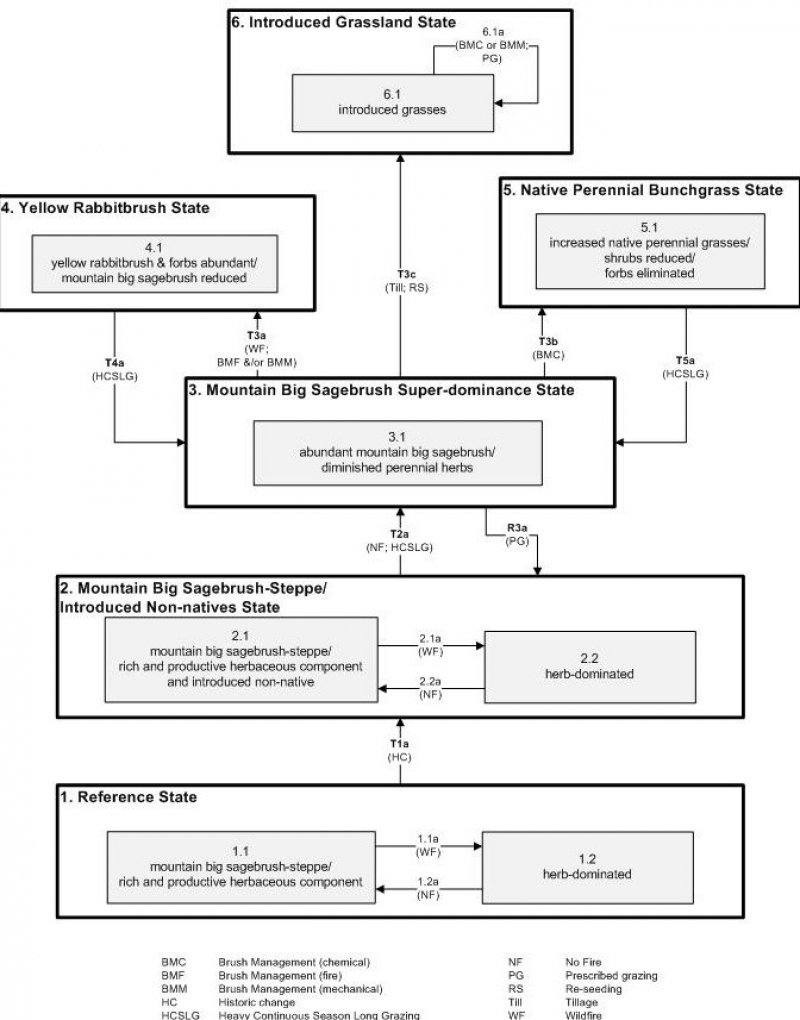
Below is a State and Transition Model diagram to illustrate the “phases” (common plant communities), and “states” (aggregations of those plant communities) that can occur on the site. Differences between phases and states depend primarily upon observations of a range of disturbance histories in areas where this ESD is represented. These situations include grazing gradients to water sources, fence-line contrasts, patches with differing dates of fire, herbicide treatment, tillage, etc. Reference State 1 illustrates the common plant communities that probably existed just prior to European settlement.
The major successional pathways within states, (“community pathways”) are indicated by arrows between phases. “Transitions” are indicated by arrows between states. The drivers of these changes are indicated in codes decipherable by referring to the legend at the bottom of the page and by reading the detailed narratives that follow the diagram. The transition between Reference State 1 and State 2 is considered irreversible because of the naturalization of exotic species of both flora and fauna, possible extinction of native species, and climate change. There may have also been accelerated soil erosion.
When available, monitoring data (of various types) were employed to validate more subjective inferences made in this diagram. See the complete files in the office of the State Range Conservationist for more details.
The plant communities shown in this State and Transition Model may not represent every possibility, but are probably the most prevalent and recurring plant communities. As more monitoring data are collected, some phases or states may be revised, removed, or new ones may be added. None of these plant communities should necessarily be thought of as “Desired Plant Communities.” According to the USDA NRCS National Range and Pasture Handbook (USDA-NRCS 2003), Desired Plant Communities (DPC’s) will be determined by the decision-makers and will meet minimum quality criteria established by the NRCS. The main purpose for including descriptions of a plant community is to capture the current knowledge at the time of this revision.
State 1: Reference State
The Reference State is a description of this ecological site just prior to Euro-American settlement but long after the arrival of Native Americans. The description of the Reference State was determined by NRCS Soil Survey Type Site Location information and familiarity with rangeland relict areas where they exist. The least modified plant community would have been co-dominated by mountain big sagebrush (Artemisia tridentata ssp. vaseyana) and a mixture of herbaceous species (1.1). The primary disturbance factor prior to European colonization would have been wildfire (1.1a), which would have removed the sagebrush and allowed the herbs to dominate for a time (1.2) As the time elapsed since the last wildfire grew longer (1.2a), mountain big sagebrush would have increased, and the herbaceous component would have decreased correspondingly. A more complete list of species by lifeform for the Reference State is available in the accompanying tables in the “Plant Community Composition by Weight and Percentage” section of this document.
Community Phase 1.1: mountain big sagebrush-steppe/ rich and productive herbaceous component
This plant community would have been characterized by the presence of mountain big sagebrush with a rich and productive herbaceous layer.
Community Pathway 1.1a:
Wildfire would remove sagebrush, allowing the herbs to dominate for a time.
Community Phase 1.2: herb dominated
This phase would have been dominated by herbaceous species and having few, if any, mountain big sagebrush present.
Community Pathway 1.2a:
Over time, sagebrush would increase, and the herbaceous understory would decrease slightly.
Transition T1a: (State 1 to State 2)
The simultaneous introduction of exotic species, both plants and animals, possible extinctions of native flora and fauna, and climate change has caused State 1 to transition to State 2. Reversal of such historic changes (i.e. a return pathway) back to State 1 is not practical.
State 2: Mountain Big Sagebrush-Steppe/ Introduced Non-natives State
State 2 is identical to State 1 in form and function, with the exception of the presence of non-native plants and animals, possible extinctions of native species, and a different climate. State 2 is a description of the ecological site shortly following Euro-American settlement. This State can be regarded as the current potential. This State varies in the amount of mountain big sagebrush present based upon the time elapsed since the last wildfire.
The least modified plant community is a mountain big sagebrush-steppe, characterized by the co-dominance shrubs and herbaceous species. Mountain big sagebrush is the dominant shrub, but other minor shrubs may be present. There is a rich and diverse mixture of herbs as well. Dominant grasses include slender wheatgrass, Geyer's Sedge, and Letterman’s needlegrass, and forbs include pale agoseris, beardtongue, and spiny phlox, among others (2.1). A small component of non-natives will also be present. Wildfire (2.1a) will remove sagebrush and allow the community to become dominated by herbaceous species for a time (2.2). As the length of time elapsed since the last wildfire grows longer (2.2a), sagebrush will re-establish, and the herbs will decrease slightly.
This State is maintained by periodic wildfire and by a healthy, productive, and diverse plant community that can provide native seed sources and promotes soil stability, water infiltration, and soil moisture retention. These sites are more resistant to accelerated soil erosion because of the self-armored of many of these gravelly soils. The resiliency of this State will be maintained by reducing or altering seasons of use and number of livestock. Conversely, this State’s resiliency will be negatively impacted by continuous season-long livestock use.
Community Phase 2.1: Mountain big sagebrush-steppe/ rich and productive herbaceous component
This plant community is characterized by co-dominance of mountain big sagebrush and a rich and productive understory of herbs.
Community Pathway 2.1a:
Wildfire will remove sagebrush, allowing the herbs to dominate for a time.
Community Phase 2.2: herb dominated
This phase is dominated by herbaceous species and having few, if any, mountain big sagebrush present.
Community Pathway 2.2a:
Over time, sagebrush will increase, and the herbaceous understory will decrease slightly.
Transition T2a: from State 2 to State 3 (Mountain Big Sagebrush-Steppe/ Introduced Non-natives State to Mountain Big Sagebrush Super-dominance State)
Lack of fire and continued heavy livestock grazing during the growing season will cause State 2 to transition into the Mountain Big sagebrush Super-dominance State (State 3). The approach to this transition is indicated by a loss of the perennial grass understory, an increase in the shrub component relative to the grasses, and evidence of soil loss. The trigger causing this transition is heavy growing-season grazing.
State 3: Mountain Big Sagebrush Super-dominance State
This State is characterized by a super-dominance of mountain big sagebrush with a markedly diminished grass component which occurs in the absence of fire and with continued heavy impacts from livestock grazing. The stability of this State is maintained by the lack of a healthy, productive and diverse herb component capable of providing native seed source, soil stabilization, and soil moisture retention, and by an abundant seed source for mountain big sagebrush. The resiliency of this State will be maintained by decreased grazing during the growing season. Conversely, the resiliency of this State will be negatively impacted by continued heavy growing-season livestock use.
Community Phase 3.1: abundant Mountain big sagebrush / diminished perennial herbs
This plant community is characterized by a dramatic increase in mountain big sagebrush with substantial reduction in the perennial herbaceous component as compared to State 2.
Transition T3a: from State 3 to State 4 (Mountain Big Sagebrush Super-dominance State to Yellow Rabbitbrush State)
Wildfire or brush management, either by mechanical means or prescribed fire, will temporarily remove the mountain big sagebrush. However, an increase in yellow rabbitbrush (Chrysothamnus viscidiflorus) is expected in most circumstances. The herbaceous component will also increase after fire or brush beating. The approach to this transition is indicated by an increase in rabbitbrush seedlings. The transition is triggered by wildfire or mechanical removal of sagebrush accompanied by heavy grazing.
Transition T3b: from State 3 to State 5 (Mountain Big Sagebrush Super-dominance State to Native Perennial Grass State)
Brush management using 2, 4-D or 2, 4-5T will remove both the shrub and forb components, leaving the grasses. This transition is triggered by herbicide application.
Transition T3c: from State 3 to State 6 (Mountain Big Sagebrush Super-dominance State to Introduced Grassland State)
This transition occurs when a decision is made to increase forage production by tilling and reseeding with intermediate wheatgrass (Thinopyrum intermedium), smooth brome (Bromus inermis), or orchardgrass (Dactylis glomerata); all introduced (non-native) species.
Restoration Pathway: R3a
Prescribed grazing during the dormant season will allow the native perennial herbaceous species to re-establish, returning the community to a mountain big sagebrush-steppe (State 2).
State 4: Yellow Rabbitbrush State
This State is characterized by having an abundance of yellow rabbitbrush and forb species and a reduced amount of mountain big sagebrush. This State occurs when the sagebrush is removed by fire or mechanical means from an area where it was previously super-dominant. This State is maintained by lack of sagebrush seedling establishment. It could also be maintained by periodic sagebrush removal by fire.
Community Phase 4.1: yellow rabbitbrush and forbs abundant/ mountain big sagebrush reduced
This Phase is characterized by having an abundance of yellow rabbitbrush and forb species and having a reduced amount of mountain big sagebrush.
Transition T4a: from State 4 to State 3 (Yellow Rabbitbrush State to Mountain Big Sagebrush Super-dominance State)
Heavy continuous season-long grazing will impact the herbaceous component, allowing the shrubs to return to dominance.
State 5: Native Perennial Bunchgrass State
This State is dominated by native perennial bunchgrasses such as slender wheatgrass, Geyer's sedge, and Letterman’s needlegrass. Shrubs and have been reduced and forbs eliminated by 2,4-D™ or 2,4-5T™ application. This State is maintained by the lack of shrub and forb seed source, and the abundance of native perennial grass seed source.
Community Phase 5.1: increased native perennial grasses/ shrubs reduced/ forbs eliminated
This Phase is characterized by the dominance of perennial native bunchgrasses such as slender wheatgrass, Geyer's sedge, and Letterman’s needlegrass. Shrubs and have been reduced and forbs eliminated.
Transition T5a: from State 5 to State 3 (Native Perennial Bunchgrass State to Mountain Big Sagebrush Super-dominance State)
Heavy continuous season-long grazing will impact the native graminoids, allowing the shrubs to return to dominance. The approach to this transition is indicated by an increase in sagebrush seedlings. This transition is triggered by heavy growing-season livestock grazing.
State 6: Introduced Grassland State
This state is characterized by the dominance of seeded grasses such as intermediate wheatgrass, smooth brome, or orchardgrass. This state occurs when a decision is made to increase forage production by tilling and reseeding introduced grasses. Periodic brush management is required to maintain the grass-dominance of this state. This resiliency of this State can be maintained by sustainable levels of livestock grazing as determined by monitoring. Conversely, continued heavy use will negatively impact the resiliency of this state.
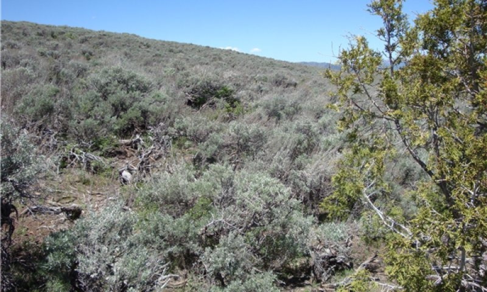
Community 1.1
Sandberg Bluegrass/Mountain Big Sagebrush

Figure 4. Plant Community Phase 1.1
This site usually falls into this community phase due to historic grazing and snow drifts that remain on the north and northwest facing sideslopes late into the spring. The mountain big sagebrush increases and grasses and forbs decrease, producing a shrub dominant community.
Table 5. Annual production by plant type
| Plant type |
Low
(lb/acre) |
Representative value
(lb/acre) |
High
(lb/acre) |
| Shrub/Vine |
415 |
550 |
900 |
| Grass/Grasslike |
300 |
400 |
655 |
| Forb |
110 |
150 |
245 |
| Total |
825 |
1100 |
1800 |
Table 6. Ground cover
| Tree foliar cover |
0-1%
|
| Shrub/vine/liana foliar cover |
20-25%
|
| Grass/grasslike foliar cover |
5-10%
|
| Forb foliar cover |
2-5%
|
| Non-vascular plants |
0%
|
| Biological crusts |
0%
|
| Litter |
20-30%
|
| Surface fragments >0.25" and <=3" |
5-25%
|
| Surface fragments >3" |
0-10%
|
| Bedrock |
0%
|
| Water |
0%
|
| Bare ground |
20-25%
|