Ecological dynamics
It is impossible to determine in any quantitative detail the Historic Climax Plant Community (HCPC) for this ecological site because of the lack of direct historical documentation preceding all human influence. In some areas, the earliest reports of dominant plants include the cadastral survey conducted by the General Land Office, which began in the late 19th century for this area (Galatowitsch 1990). However, up to the 1870s the Shoshone Indians, prevalent in northern Utah and neighboring states, grazed horses and set fires to alter the vegetation for their needs (Parson 1996). In the 1860s, Europeans brought cattle and horses to the area, grazing large numbers of them on unfenced parcels year-long (Parson 1996). Itinerant and local sheep flocks followed, largely replacing cattle as the browse component increased.
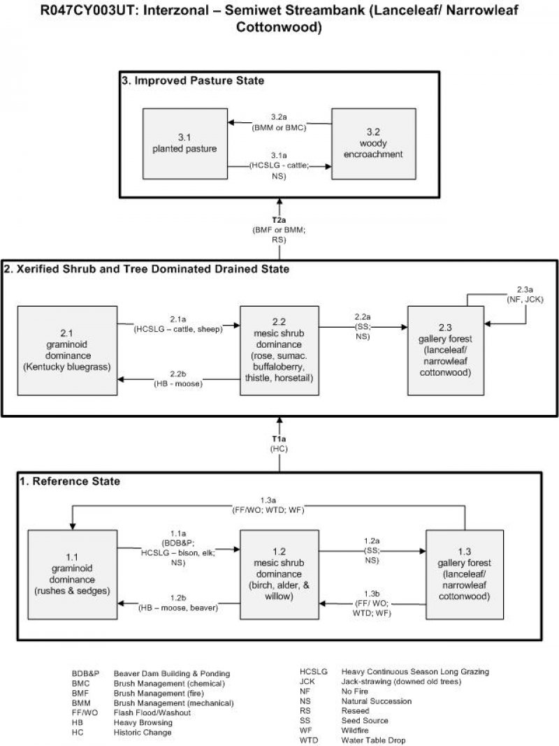
Below is a State and Transition Model diagram to illustrate the “phases” (common plant communities), and “states” (aggregations of those plant communities) that can occur on the site. Differences between phases and states depend primarily upon observations of a range of disturbance histories in areas where this ESD is represented. These situations include grazing gradients to water sources, fence-line contrasts, patches with differing dates of fire, herbicide treatment, tillage, etc. Reference State 1 illustrates the common plant communities that probably existed just prior to European settlement.
The major successional pathways within states, (“community pathways”) are indicated by arrows between phases. “Transitions” are indicated by arrows between states. The drivers of these changes are indicated in codes decipherable by referring to the legend at the bottom of the page and by reading the detailed narratives that follow the diagram. The transition between Reference State 1 and State 2 is considered irreversible because of the naturalization of exotic species of both flora and fauna, possible extinction of native species, and climate change. There may have also been accelerated soil erosion.
When available, monitoring data (of various types) were employed to validate more subjective inferences made in this diagram. See the complete files in the office of the State Range Conservationist for more details.
The plant communities shown in this State and Transition Model may not represent every possibility, but are probably the most prevalent and recurring plant communities. As more monitoring data are collected, some phases or states may be revised, removed, or new ones may be added. None of these plant communities should necessarily be thought of as “Desired Plant Communities.” According to the USDA NRCS National Range and Pasture Handbook (USDA-NRCS 2003), Desired Plant Communities (DPC’s) will be determined by the decision-makers and will meet minimum quality criteria established by the NRCS. The main purpose for including descriptions of a plant community is to capture the current knowledge at the time of this revision.
Community 1.1
Reference State
The Reference State is a description of this ecological site just prior to Euro-American settlement but long after the arrival of Native Americans. The description of the Reference State was determined by NRCS Soil Survey Type Site Location information and familiarity with rangeland relict areas where they exist. The Reference State would have been in any of three phases depending on stream gradient and how recently fire had occurred or when beavers had last been present. Along steeper stream gradients, succession would have rapidly proceeded from low-statured graminoids (1.1), to shrubs (1.2), and lastly to trees that reproduce in their own shade (1.3). A complete list of species by lifeform for the Reference State is available in accompanying tables in the “Plant Community Composition by Weight and Percentage” section of this document. Along gentle gradients beavers would have consumed all the largely deciduous woody stems and constructed dams. Once the nearby food and building materials were exhausted, the colony of beavers would have moved to another reach of the stream, making the abandoned dams and depleted stretch vulnerable to blow out from the next large convectional storm. This phase is short since most of the woody species re-sprout and are dominant again within a decade or so.
The resulting drop in the water table would have stressed the moisture-demanding woody species and favored the graminoids, allowing the graminoids to eventually reclaim the drier streamside banks. Thus, rather than one plant community becoming stable, these stretches of stream would have been in a continual state of change. Fur trapping in the 1820s to 1830s resulted in the reduction of beaver by about 95 percent (Parson 1996). Without these animals to maintain their stair-step configuration of dams, the whole hydrologic regime of these drainages changed. What were once small perennial streams became ephemeral, and succession was truncated. Beaver have not returned in number until recent decades (when the fur trade diminished and furbearers began to be raised on farms). Thus, by the time of the European settlement period, huge changes in these systems had already taken place.
Community Phase 1.1: graminoid dominance (rushes & sedges)
This early seral phase would have been dominated by rushes (Juncus spp.), sedges (Carex spp.), and native perennial water-demanding species such as reed canarygrass (Phalaris arundinacea), mat muhly (Muhlenbergia richardsonis), and mountain brome (Bromus marginatus). Heavy local utilization by moose or beaver would have kept back the woody species, allowing this graminoid phase to persist.
Community Pathway 1.1a:
Along gentler stream gradients, ponding caused by construction of beaver dams would have brought the water table up in areas that would have otherwise been dry. Heavy grazing by bison and elk would have reduced the graminoids, giving way first to some taller forbs such as Missouri goldenrod (Solidago missouriensis) and feathery false lily of the valley (Maianthemum racemosum). Quickly following were a set of water-loving shrubs and small trees including water birch (Betula occidentalis), yellow willow (Salix lutea), and gray alder (Alnus incana). The same successional process would have taken place along steeper gradients, but at a more rapid rate.
Community Phase 1.2: mesic shrub dominance (birch, alder, & willow)
A set of mesic shrubs including water birch, yellow willow, and gray alder would have quickly overtopped the graminoids, unless shrubs were cropped by moose or beaver.
Community Pathway 1.2a:
The presence of lanceleaf cottonwood (Populus ×acuminata) and/or narrowleaf cottonwood (Populus angustifolia) seeds being carried by water would have provided for the rapid succession from shrubs to a gallery forest.
Community Pathway 1.2b:
As the supply of palatable deciduous shrubs and trees increased, beaver numbers would also have increased. With time, a heavy concentration of beaver and moose would have reduced the woody component, with the exception of the less palatable shrubs (e.g. Woods’ rose (Rosa woodsii) and hawthorn (Crataegus douglasii)), causing the canopy to open up.
Community Phase 1.3: gallery forest (lanceleaf/ narrowleaf cottonwood)
Without beaver, tree cutting, and fire, a thick streamside (gallery) forest dominated by shade-tolerant lanceleaf or narrowleaf cottonwood would have developed.
Community Pathway 1.3a:
A strong convectional storm associated with flash flooding would have blown out existing beaver dams. Unless the beavers were still occupying the area and rebuilt their dams, the water table would have eventually returned to previously lower levels. This would have allowed the graminoids to reclaim the site. Wildfire would have had a similar effect by removing most of the woody vegetation and debris, thereby re-opening the site to graminoids.
Community Pathway 1.3b:
This community pathway would be similar to 1.2b, except less intense. Flash flooding may blow out existing beaver dams following convectional storm events, but some smaller-statured trees and shrubs would persist, leaving enough woody material such that beavers could subsist and rebuild their dams.
Transition T1a: from State 1 to State 2 (Reference State to Xerified Shrub and Tree Dominated Drained State)
The simultaneous introduction of European livestock and exotic plant species, the near extirpation of beaver along with its influence on the hydrologic regime, and a warmer drier climate were all factors involved in the transition to State 2. A return to State 1 would not be impractical because of these issues.
Table 5. Annual production by plant type
| Plant type |
Low
(lb/acre) |
Representative value
(lb/acre) |
High
(lb/acre) |
| Grass/Grasslike |
780 |
920 |
1060 |
| Forb |
585 |
690 |
795 |
| Shrub/Vine |
585 |
690 |
795 |
| Total |
1950 |
2300 |
2650 |
Table 6. Ground cover
| Tree foliar cover |
4-6%
|
| Shrub/vine/liana foliar cover |
49-51%
|
| Grass/grasslike foliar cover |
14-16%
|
| Forb foliar cover |
9-11%
|
| Non-vascular plants |
0%
|
| Biological crusts |
0%
|
| Litter |
0%
|
| Surface fragments >0.25" and <=3" |
0%
|
| Surface fragments >3" |
0%
|
| Bedrock |
0%
|
| Water |
0%
|
| Bare ground |
0%
|
Table 7. Canopy structure (% cover)
| Height Above Ground (ft) |
Tree |
Shrub/Vine |
Grass/
Grasslike |
Forb |
| <0.5 |
– |
– |
– |
– |
| >0.5 <= 1 |
– |
– |
14-16% |
– |
| >1 <= 2 |
– |
– |
– |
9-11% |
| >2 <= 4.5 |
– |
– |
– |
– |
| >4.5 <= 13 |
– |
– |
– |
– |
| >13 <= 40 |
– |
49-51% |
– |
– |
| >40 <= 80 |
4-6% |
– |
– |
– |
| >80 <= 120 |
– |
– |
– |
– |
| >120 |
– |
– |
– |
– |
State 2
Xerified Shrub and Tree Dominated Drained State
Community 2.1
Xerified Shrub and Tree Dominated Drained State
State 2 is similar to State 1 in form and function, with the exception of the presence of non-native plants and animals, possible extinctions, and a different climate. State 2 is a description of the ecological site shortly following Euro-American settlement. This state can be regarded as the current potential. Depending on the size of the watershed above, the stream could well have changed from a perennial to ephemeral drainage. Many of the same species of plants found in the Reference State continue to exist in the latter situation because of hyporheic (i.e. below ground) movement of water, although the period of greenery and its productivity are lessened. The introduction of cattle put pressure on the graminoids (2.1a) and hastened the conversion to shrubs (2.2). The lack of beaver dams meant that sediment moved more rapidly downstream with flashy (short duration, high intensity) precipitation events. Stream channelization occurred with increased rates of flow, leading to xerification of the streamside. With beaver temporarily absent, livestock numbers relatively reduced due to lack of forage, and lack of natural disturbances (2.2a), the shrubs and trees grow larger and shade out many of the forage species favored by livestock (2.3). The most disturbed phase of this State would be the graminoid-dominant phase (2.1), which occurs if moose effectively browse out the shrubby vegetation (2.2b). Kentucky bluegrass (Poa pratensis) was introduced at some sites for livestock forage; however it is not capable of holding the stream banks together during convectional storms.
Community Phase 2.1: graminoid dominance
This graminoid-dominated phase is frequently dominated by Kentucky bluegrass. The Forest Service regards this as an introduced species, but it is preferred by livestock over other native graminoids. It is, however, less able to protect stream banks than its native counterparts because of its shallower, weaker roots.
Community Pathway 2.1a:
Heavy season-long use by cattle will diminish the grass component and allow an increase in tall forbs. Sheep will consume most of the forbs and shrubs, but will leave the thistles (Cirsium spp.), horsetail (Equisetum spp.), Woods’ rose, skunkbush sumac (Rhus trilobata), and silver buffaloberry (Shepherdia argentea).
Community Phase 2.2: mesic shrub dominance
This plant community will be dominated by unpalatable mesic shrubs such as Woods’ rose, sumac, and silver buffaloberry, with an understory of unpalatable herbs including thistles and horsetail. Species composition will depend upon the type of livestock utilizing the area.
Community Pathway 2.2a:
Without moose and/or beaver consumption of shrubs and sapling trees, the shrub phase quickly transforms to a gallery forest.
Community Pathway 2.2b:
Moose have become more abundant of late and focus their attention on yellow willow and water birch, especially during the winter. This will cause a retardation of the shift to shrub and tree dominance.
Community Phase 2.3: gallery forest (lanceleaf/ narrowleaf cottonwood)
This plant community is dominated by lanceleaf and/or narrowleaf cottonwood, a shade-tolerant species, which will persist in the absence of wildfire, wood cutting, and/or large storm events.
Community Pathway 2.3a:
A gallery forest can persist in the absence of fire or wood cutting, creating a jack-strawing of downed trees that will make access to the site difficult for large animals.
Transition T2a: from State 2 to State 3 (Xerified Shrub and Tree Dominated Drained State to Improved Pasture State)
Since there is diminished forage production in the woody plant-dominated phases of State 2, some private landholders have, through prescribed fire and mechanical treatments, cleared out the streamside vegetation and planted exotic species such as smooth brome (Bromus inermis) or orchardgrass (Dactylis glomerata) to replace the native species.
State 3
Improved Pasture State
Community 3.1
Improved Pasture State
Some private land owners have bulldozed the streamside vegetation to remove trees needed by beavers to pond up the stream or to remove shade to increase forage production for livestock. Introduced species such as orchardgrass and smooth brome have been planted as the site became xerified, but more conducive to cattle grazing. The early seral vegetation created constitutes Phase 3.1. With time and heavy cattle grazing (3.1a), the tendency is for the original shrubs and trees to return (3.2). If introduced grass dominance is desired, mechanical or chemical re-treatment to reduce the woody plants will be required (3.2a).
Community Phase 3.1: planted pasture
This plant community will be dominated by introduced species such as orchardgrass and smooth brome.
Community Pathway 3.1a:
In order to maintain an herbaceous-dominant phase, the native woody species may require re-treatment using mechanical or chemical means.
Community Phase 3.2: woody encroachment
This plant community will be a mix of introduced grasses and native shrubs that have re-established following a period of heavy continuous season-long grazing.
Community Pathway 3.2a:
Some re-establishment of native shrubs will occur if the site is heavily grazed during the growing season of the grasses.