Natural Resources
Conservation Service
Ecological site R047XC474UT
Mountain Very Steep Stony Loam (shrub)
Last updated: 2/11/2025
Accessed: 04/03/2026
General information
Provisional. A provisional ecological site description has undergone quality control and quality assurance review. It contains a working state and transition model and enough information to identify the ecological site.
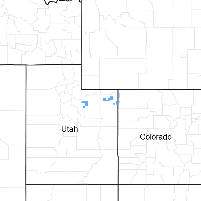
Figure 1. Mapped extent
Areas shown in blue indicate the maximum mapped extent of this ecological site. Other ecological sites likely occur within the highlighted areas. It is also possible for this ecological site to occur outside of highlighted areas if detailed soil survey has not been completed or recently updated.
MLRA notes
Major Land Resource Area (MLRA): 047X–Wasatch and Uinta Mountains
MLRA 47 occurs in Utah (86 percent), Wyoming (8 percent), Colorado (4 percent), and Idaho (2 percent). It encompasses approximately 23,825 square miles (61,740 square kilometers). The northern half of this area is in the Middle Rocky Mountains Province of the Rocky Mountain System. The southern half is in the High Plateaus of the Utah Section of the Colorado Plateaus Province of the Intermontane Plateaus. Parts of the western edge of this MLRA are in the Great Basin Section of the Basin and Range Province of the Intermontane Plateaus. The MLRA includes the Wasatch Mountains, which trend north and south, and the Uinta Mountains, which trend east and west. The steeply sloping, precipitous Wasatch Mountains have narrow crests and deep valleys. Active faulting and erosion are a dominant force in controlling the geomorphology of the area. The Uinta Mountains have a broad, gently arching, elongated shape. Structurally, they consist of a broadly folded anticline that has an erosion-resistant quartzite core. The Wasatch and Uinta Mountains have an elevation of 4,900 to about 13,500 feet (1,495 to 4,115 meters).
The mountains in this area are primarily fault blocks that have been tilted up. Alluvial fans at the base of the mountains are recharge zones for the basin fill aquifers. An ancient shoreline of historic Bonneville Lake is evident on the footslopes along the western edge of the area. Rocks exposed in the mountains are mostly Mesozoic and Paleozoic sediments, but Precambrian rocks are exposed in the Uinta Mountains. The Uinta Mountains are one of the few ranges in the United States that are oriented west to east. The southern Wasatch Mountains consist of Tertiary volcanic rocks occurring as extrusive lava and intrusive crystalline rocks.
The average precipitation is from 8 to 16 inches (203 to 406 mm) in the valleys and can range up to 73 inches (1854 mm) in the mountains. In the northern and western portions of the MLRA, peak precipitation occurs in the winter months. The southern and eastern portions have a greater incidence of high-intensity summer thunderstorms; hence, a significant amount of precipitation occurs during the summer months. The average annual temperature is 30 to 50 degrees Fahrenheit (-1 to 15 C). The freeze-free period averages 140 days and ranges from 60 to 220 days, generally decreasing in length with elevation.
The dominant soil orders in this MLRA are Aridisols, Entisols, Inceptisols, and Mollisols. The lower elevations are dominated by a frigid temperature regime, while the higher elevations experience cryic temperature regimes. Mesic temperature regimes come in on the lower elevations and south facing slopes in the southern portion of this MLRA. The soil moisture regime is typically xeric in the northern part of the MLRA, but grades to ustic in the extreme eastern and southern parts. The minerology is generally mixed and the soils are very shallow to very deep, generally well drained, and loamy or loamy-skeletal.
LRU notes
E47C is the Uinta Mountains portion of MLRA 47 that run east and west which includes the Uinta Wilderness and The Flaming Gorge National Recreation Area and towns such as Evanston, Wyoming, Hanna and Tabiona, Utah. Structurally these mountains consist of a broadly folded anticline that has an erosion resistance quartzite core. The Duchesne River and many other tributaries to the Green River run through this range, as well as the headwaters of the Bear River.
Ecological site concept
The soils of this site formed in colluvium over residuum derived primarily from sandstone and shale. Surface textures are very flaggery, fine sandy loams or extremely stony loamy sands. Subsurface textures are loamy sands or sandy loams and typically contain greater than 50 percent rock fragments by volume. Rock fragments are visible on the soil surface. These soils are deep, well to excessively drained and have moderately rapid to rapid permeability. They are slightly alkaline and slightly calcareous. Available water-holding capacity ranges from 1 to 3.5 inches of water in the upper 40 inches of soil. The soil moisture regime is ustic and the soil temperature regime is frigid.
Associated sites
| R047XC430UT |
Mountain Loam (mountain big sagebrush) |
|---|---|
| R047XC460UT |
Mountain Stony Loam (shrub) |
Similar sites
| R047XC460UT |
Mountain Stony Loam (shrub) |
|---|
Table 1. Dominant plant species
| Tree |
Not specified |
|---|---|
| Shrub |
(1) Cercocarpus montanus |
| Herbaceous |
(1) Pseudoroegneria spicata |
Physiographic features
This site occurs on steep to very steep mountain and hill slopes at elevations between 6,200 and 8,000 feet. It may occur on all aspects an slopes ranging from 40 to 80 percent.
Table 2. Representative physiographic features
| Landforms |
(1)
Mountain slope
(2) Hill |
|---|---|
| Flooding frequency | None |
| Ponding frequency | None |
| Elevation | 6,200 – 8,000 ft |
| Slope | 40 – 80% |
| Aspect | Aspect is not a significant factor |
Climatic features
The climate is characterized by cool, moist summers and cold, snowy winters. Approximately 60 percent of the moisture comes as rain from May through October. On the average, January through April are the driest months and May through October are the wettest months. The soil moistire regime is ustic and soil tempertaure regime is frigid.
Table 3. Representative climatic features
| Frost-free period (characteristic range) | |
|---|---|
| Freeze-free period (characteristic range) | 60-110 days |
| Precipitation total (characteristic range) | 14-25 in |
Influencing water features
Due to its landscape position, this site is not influenced by streams or wetlands.
Wetland description
N/A
Soil features
The soils of this site formed in colluvium over residuum derived primarily from sandstone and shale. Surface textures are very flaggery, fine sandy loams or extremely stony loamy sands. Subsurface textures are loamy sands or sandy loams and typically contain greater than 50 percent rock fragments by volume. Rock fragments are visible on the soil surface. These soils are deep, well to excessively drained and have moderately rapid to rapid permeability. They are slightly alkaline and slightly calcareous. Available water-holding capacity ranges from 1 to 3.5 inches of water. The soil moisture regime is ustic and the soil temperature regime is frigid.
Modal Soil: Sheecal CB-L, 40-60% Eroded — fine-loamy, mixed (calc.), frigid Typic Ustorthents
Table 4. Representative soil features
| Parent material |
(1)
Colluvium
–
sandstone and shale
(2) Residuum – sandstone and shale |
|---|---|
| Surface texture |
(1) Very flaggy fine sandy loam (2) Extremely stony loamy sand |
| Drainage class | Well drained to excessively drained |
| Permeability class | Moderately rapid to rapid |
| Soil depth | 40 – 60 in |
| Surface fragment cover <=3" | 16 – 25% |
| Surface fragment cover >3" | 41 – 50% |
| Available water capacity (Depth not specified) |
1 – 3.5 in |
| Calcium carbonate equivalent (Depth not specified) |
10% |
| Electrical conductivity (Depth not specified) |
2 mmhos/cm |
| Sodium adsorption ratio (Depth not specified) |
Not specified |
| Soil reaction (1:1 water) (Depth not specified) |
7.4 – 8.4 |
| Subsurface fragment volume <=3" (Depth not specified) |
15 – 22% |
| Subsurface fragment volume >3" (Depth not specified) |
37 – 49% |
Ecological dynamics
It is impossible to determine in any quantitative detail the Historic Climax Plant Community (HCPC) for this ecological site because of the lack of direct historical documentation preceding all human influence. In some areas, the earliest reports of dominant plants include the cadastral survey conducted by the General Land Office, which began in the late 19th century for this area (Galatowitsch 1990). However, up to the 1870s the Shoshone Indians, prevalent in northern Utah and neighboring states, grazed horses and set fires to alter the vegetation for their needs (Parson 1996). In the 1860s, Europeans brought cattle and horses to the area, grazing large numbers of them on unfenced parcels year-long (Parson 1996). Itinerant and local sheep flocks followed, largely replacing cattle as the browse component increased.
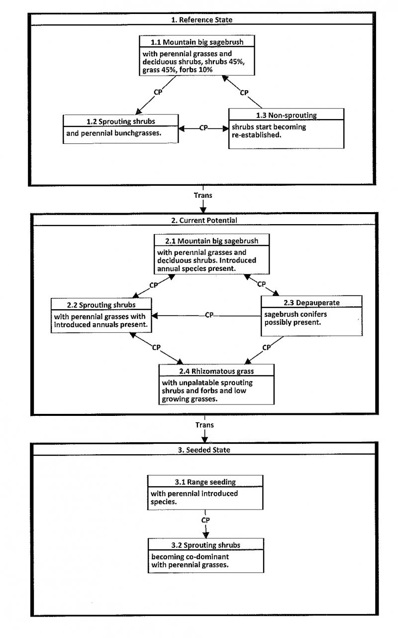
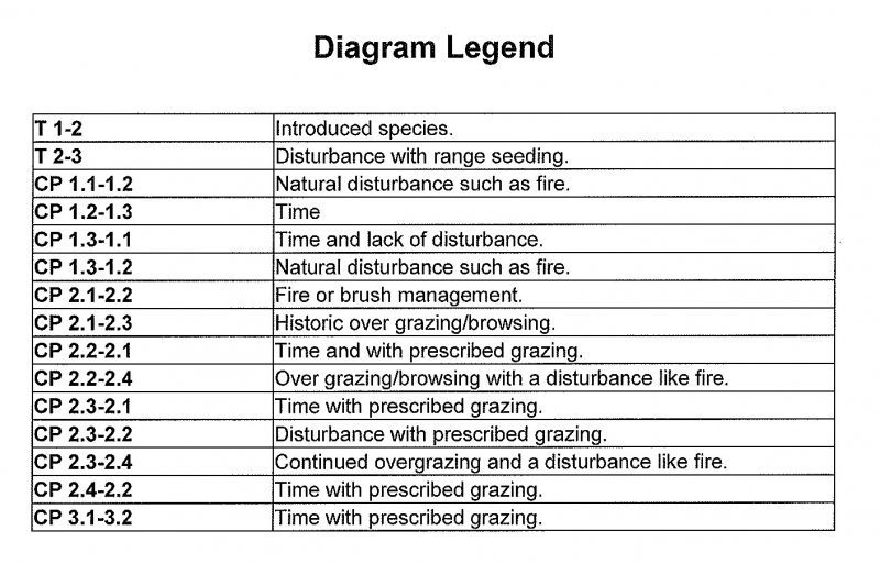
Below is a State and Transition Model diagram to illustrate the “phases” (common plant communities), and “states” (aggregations of those plant communities) that can occur on the site. Differences between phases and states depend primarily upon observations of a range of disturbance histories in areas where this ESD is represented. These situations include grazing gradients to water sources, fence-line contrasts, patches with differing dates of fire, herbicide treatment, tillage, etc. Reference State 1 illustrates the common plant communities that probably existed just prior to European settlement.
The major successional pathways within states, (“community pathways”) are indicated by arrows between phases. “Transitions” are indicated by arrows between states. The drivers of these changes are indicated in codes decipherable by referring to the legend at the bottom of the page and by reading the detailed narratives that follow the diagram. The transition between Reference State 1 and State 2 is considered irreversible because of the naturalization of exotic species of both flora and fauna, possible extinction of native species, and climate change. There may have also been accelerated soil erosion.
When available, monitoring data (of various types) were employed to validate more subjective inferences made in this diagram. See the complete files in the office of the State Range Conservationist for more detail.
The plant communities shown in this State and Transition Model may not represent every possibility, but are probably the most prevalent and recurring plant communities. As more monitoring data are collected, some phases or states may be revised, removed, and/or new ones may be added. None of these plant communities should necessarily be thought of as “Desired Plant Communities.” According to the USDA NRCS National Range & Pasture Handbook (USDA-NRCS 2003), Desired Plant Communities (DPC’s) will be determined by the decision-makers and will meet minimum quality criteria established by the NRCS. The main purpose for including descriptions of a plant community is to capture the current knowledge at the time of this revision.
State 1: Reference State:
The Reference State is a description of this ecological site just prior to Euro-American settlement but long after the arrival of Native Americans. The description of the Reference State was determined by NRCS Soil Survey Type Site Location information and familiarity with rangeland relict areas where they exist. The least modified plant community (1.1) within the Reference State would have been a sagebrush-dominated stand with mountain big sagebrush (Artemisia tridentate spp. vaseyana), mountain snowberry (Symphoricarpos oreophilus) and associated bunch grasses such as bluebunch wheatgrass (Pseudoroegeneria spicata), Nevada bluegrass (Poa secunda) and slender wheatgrass (Elymus trachycaulus). Forbs such as Arrowleaf balsamroot (Balsamorhiza sagittata), sticky purple geranium (Geranium viscosissimum) and fleabane (Erigeron sp.) would be present. Fire is believed to be the dominant disturbance force in natural big sagebrush communities. The Reference Plant Community (1.1) would have been relatively stable with occasional use by wildlife. Following a natural fire (1.1a) and depending on the severity, would have killed most if not all of the sagebrush favoring the sprouting shrubs and bunchgrasses (1.2). Over time and without any further disturbances (1.2a) sagebrush and other non-sprouting shrubs would slowly come back into the site (1.3), however the sprouting shrubs and bunch grasses would still dominate the site. If there were another fire to occur on the site (1.3a) the site would return to community phase 1.2. If community phase 1.3 continued to experience no disturbances over a longer period of time (1.3b) it would eventually show a co-dominance between mountain big sagebrush and the other shrubs on the site. A more complete list of species by lifeform for the Reference State is available in the accompanying tables in the “Plant Community Composition by Weight and Percentage” section of this document.
Community Phase 1.1 Mountain big sagebrush with perennial grasses and deciduous shrubs.
The least modified plant community within the Reference State would have been a mountain big sagebrush-dominated with associated deciduous shrubs such as mountain snowberry, antelope bitterbrush, serviceberry and associated perennial grasses such as bluebunch wheatgrass and slender wheatgrass. Arrowleaf balsamroot, sticky purple geranium and erigeron species would have been the commonly associated forbs. Percent composition would have been 45 percent shrubs, 45 percent grasses and 15 percent forbs.
Community Pathway 1.1a
A naturally occurring fire would have killed all the non-sprouting shrubs like mountain big sagebrush. As the site recovered, it would be converted to the sprouting shrubs with perennial bunchgrasses community.
Community Phase 1.2 Sprouting shrubs with perennial bunch grasses.
Fire is a naturally occurring disturbance on this site and would have kept shrubs like mountain big sagebrush and antelope bitterbrush less dominant. Sprouting shrubs like mountain snowberry and serviceberry and perennial grasses would have become the dominant aspect of this site.
Community Pathway 1.2a
Over time and without the occurrence of a natural disturbance, such as fire, non-sprouting shrubs like mountain big sagebrush, antelope bitterbrush and alderleaf mountain mahogany would become re-established on the site.
Community Phase 1.3 Non-sprouting shrubs start becoming re-established.
Non-sprouting shrubs start becoming re-established from seed over time. Sprouting shrubs and perennial grasses are still the dominant aspect of this site.
Community Pathway 1.3a
In the event that there is another natural disturbance, like a fire, the site would return to
the sprouting shrubs with perennial bunch grasses community.
Community Pathway 1.3b
Over time and with the absence of a natural disturbance, like fire, the non-sprouting
shrubs will continue becoming more abundant to a point where they are co-dominant
with the sprouting shrubs.
T1a: Transition from State 1 to State 2 (Reference State to Current Potential/ Introduced Non-natives State)
The simultaneous introduction of exotic species, both plants and animals, and possible extinctions of native flora and fauna, along with climate change, will cause State 1 to transition to State 2. A return pathway back to State 1 would be impracticable because of these issues.
State 2: Current Potential/Introduced Non-Natives State.
State 2 is identical to State 1 in form and function, with the exception of the presence of non-native plants and animals, possible extinctions of native species, and a different climate. State 2 is a description of the ecological site shortly following Euro-American settlement, which can be regarded as the current potential. The least modified plant community (2.1) within State 2 is a sagebrush (Artemisia tridentate spp. vaseyana) dominated state with mountain snowberry (Symphoricarpos oreophilus) and associated bunch grasses such as bluebunch wheatgrass (Pseudoroegeneria spicata), Nevada bluegrass (Poa secunda) and slender wheatgrass (Elymus trachycaulus). Forbs such as Arrowleaf balsamroot (Balsamorhiza sagittata), sticky purple geranium (Geranium viscosissimum) and fleabane (Erigeron sp.) would be present. A common non-native species in this state is cheatgrass. Fire is believed to be the dominant disturbance force in natural big sagebrush communities. Following brush management or fire (2.1a) and depending on the severity, would have killed most if not all of the sagebrush, and other non-sprouting shrubs, favoring the sprouting shrubs and bunchgrasses (2.2). This plant community is relatively stable under mixed use by wildlife and livestock. However, heavy utilization by bison, elk, horses, and domestic cattle on these sites during the growing season (2.1b) would deplete the grasses and deciduous shrubs creating site that is dominated by mountain big sagebrush (2.3). In community 2.2, when management, such as prescribed grazing, can be combined with time (2.2a) to allow the site to recover returning to community 2.1. However if the community continues to be over utilized by both wildlife and domestic livestock, and possibly in combination with a natural or man caused disturbance (2.2b) this community (2.2) can be degraded to community 2.4 which is dominated by rhizomatous grasses with unpalatable sprouting shrubs and forbs. In community 2.3 when management, such as prescribed grazing coupled with time, (2.3a) the sprouting shrubs and perennial grasses can have an opportunity to recover and recolonize the site and return to community 2.1. In community 2.3, when it experiences a disturbance such as brush management or fire, coupled with management like prescribed grazing (2.3b) it can drive the site to a more stable and diverse community 2.2. However, when community 2.3 continues to be over utilized and this is coupled with a disturbance such as brush management or fire (2.3c) it can drive the site to an undesirable community 2.4.
Community Phase 2.1: Mountain big sagebrush with perennial grasses and deciduous shrubs. Introduced annual species present.
The least modified community within the mountain big sagebrush/deciduous shrub/introduced state. This is a mountain big sagebrush dominated community with an abundance of deciduous shrubs such as mountain snowberry, antelope bitterbrush and serviceberry. Community is also characterized by an abundance of native perennial grasses such as, bluebunch wheatgrass, slender wheatgrass and Nevada bluegrass. Associated forbs on this site may consist of arrowleaf balsamroot, sticky purple geranium and erigeron sp. Introduced species likely to occur on this site are cheatgrass, annual forbs, milkweed and stickseed.
Community Pathway 2.1a
This pathway is characterized by the implementation of brush management, prescribed or natural fire. This will reduce the abundance of non-sprouting shrubs giving the competitive advantage to sprouting shrubs and native perennial grasses (2.2).
Community Pathway 2.1b
Heavy continuous grazing and browsing by wildlife and domestic animals would deplete resources of the deciduous shrubs and native perennial grasses (2.3).
Community Phase 2.2: Sprouting shrubs with perennial grasses with introduced annuals present.
This community represents what the site would look like following brush management or a natural or prescribed fire. Depending on the severity of the fire/management practice, some or all of the non-sprouting shrubs would be killed. This would open up resources for the sprouting shrubs and native perennial grasses subsequently they would be the dominant aspect of the site.
Community Pathway 2.2a
This pathway represents that over time and under normal climatic conditions, along with prescribed grazing, this community would return to the previous community (2.1).
Community Pathway 2.2b
This pathway represents when the community experiences heavy continuous grazing and browsing by wildlife and domestic animals. Natural disturbances such as fire could also occur simultaneously in this pathway (2.4).
Community Phase 2.3: Depauperate sagebrush with conifers possibly present.
This community represents what the site would look like following a long period of over grazing and browsing. The more palatable species would be heavily utilized giving a competitive advantage to species such as mountain big sagebrush. Over time sagebrush would be the dominant aspect of the site with a low diversity of the other native species that normally occur on the site.
Community Pathway 2.3a
This pathway represents that over time and under normal climatic conditions, along with prescribed grazing, this community would return to the previous community (2.1).
Community Pathway 2.3b
This pathway represents that over time and under normal climatic conditions, along with prescribed grazing along with a natural or prescribed fire or brush management mountain big sagebrush/conifers would be killed. This would stimulate the sprouting shrubs and perennial native grasses moving the site to community 2.2.
Community Pathway 2.3c
This pathway represents the occurrence when the site continues to be overgrazed and there is a disturbance like a fire. Non-sprouting shrubs and conifers, if present, would be killed. Deciduous shrubs and native perennial grasses are already at low diversity and stressed, giving the competitive advantage to rhizomatous grasses and unpalatable sprouting shrubs like rabbitbrush (2.4).
Community Phase 2.4: Rhizomatous grasses with unpalatable sprouting shrubs and forbs with low growing grasses.
This community represents the site when there has been continued overgrazing/browsing for an extended period of time, followed by a disturbance such as a brush management treatment or natural/prescribed fire. Species diversity was already low (2.3). The overutilization of the desirable native vegetation coupled with the fire has reduced the site to unpalatable sprouting shrubs and forbs along with low growing grasses.
Community Pathway 2.4a
This pathway represents that over time, along with prescribed grazing that the sprouting shrubs and native perennial grasses would eventually re-establish and return the site back to community 2.2.
T2a: Transition from State 2 to State 3 (Current Potential to Seeded State)
When land managers or landowners have made the decision that the herbaceous understory species are so depleted and/or undesirable, and the biological, hydrological and soil resources are at risk, introduced and native perennial grasses are utilized in a range seeding. This often occurs in combination with a natural/prescribed fire or other brush management treatment.
State 4: Seeded State:
This State occurs where historic excessive livestock grazing reduced canopy cover, and in an attempt to prevent any additional excessive erosion it was intentionally seeded with species such as smooth brome and crested wheatgrass. Do to the decreased canopy cover and increased erosion, and rangeland seeding is utilized, either rangeland drilled or aerial application with predominately introduced species.
Community Phase 3.1: Range seeding with perennial introduced species.
This community represents a time shortly following a brush management treatment/fire in addition to the range seeding. Non-sprouting shrubs have been greatly reduced and sprouting shrubs have not had adequate time to become re-established. Introduced and native grass species with a few sprouting shrubs dominate the site.
Community Pathway 3.1a
Over an extended period of time and in combination with prescribed grazing, the native desirable sprouting shrubs begin to become well established.
Community Phase 3.2: Sprouting shrubs becoming co-dominant with perennial grasses.
This community phase represents the site over a 5 to 10 year period of time under normal climatic conditions. The desirable sprouting shrubs have had adequate time to re-establish and become co-dominant with the perennial grasses. Non-sprouting shrubs have also started to re-establish on the site as well. It is imperative that prescribed grazing must be implemented in order for this community to be persist.
State and transition model
More interactive model formats are also available.
View Interactive Models
Click on state and transition labels to scroll to the respective text
Ecosystem states
State 1 submodel, plant communities
State 1
Reference State
Community 1.1
Reference Plant Community
The general view of this site is birchleaf mountain mahogany and serviceberry. The composition by air-dry weight is approximately 35 percent perennial grasses, 10 percent forbs, and 55 percent shrubs.
Figure 2. Annual production by plant type (representative values) or group (midpoint values)
Table 5. Annual production by plant type
| Plant type | Low (lb/acre) |
Representative value (lb/acre) |
High (lb/acre) |
|---|---|---|---|
| Shrub/Vine | 412 | 632 | 797 |
| Grass/Grasslike | 263 | 403 | 508 |
| Forb | 75 | 115 | 145 |
| Total | 750 | 1150 | 1450 |
Table 6. Ground cover
| Tree foliar cover | 0% |
|---|---|
| Shrub/vine/liana foliar cover | 34-36% |
| Grass/grasslike foliar cover | 19-21% |
| Forb foliar cover | 4-6% |
| Non-vascular plants | 0% |
| Biological crusts | 0% |
| Litter | 0% |
| Surface fragments >0.25" and <=3" | 0% |
| Surface fragments >3" | 0% |
| Bedrock | 0% |
| Water | 0% |
| Bare ground | 0% |
Table 7. Canopy structure (% cover)
| Height Above Ground (ft) | Tree | Shrub/Vine | Grass/ Grasslike |
Forb |
|---|---|---|---|---|
| <0.5 | – | – | – | – |
| >0.5 <= 1 | – | – | – | 4-6% |
| >1 <= 2 | – | – | 19-21% | – |
| >2 <= 4.5 | – | 34-36% | – | – |
| >4.5 <= 13 | – | – | – | – |
| >13 <= 40 | – | – | – | – |
| >40 <= 80 | – | – | – | – |
| >80 <= 120 | – | – | – | – |
| >120 | – | – | – | – |
Additional community tables
Table 8. Community 1.1 plant community composition
| Group | Common name | Symbol | Scientific name | Annual production (lb/acre) | Foliar cover (%) | |
|---|---|---|---|---|---|---|
|
Tree
|
||||||
| 1 | Dominant Trees | 0–24 | ||||
| Rocky Mountain juniper | JUSC2 | Juniperus scopulorum | 0–24 | – | ||
|
Shrub/Vine
|
||||||
| 2 | Dominant Shrubs | 420–600 | ||||
| Utah serviceberry | AMUT | Amelanchier utahensis | 180–240 | – | ||
| alderleaf mountain mahogany | CEMO2 | Cercocarpus montanus | 180–240 | – | ||
| mountain big sagebrush | ARTRV | Artemisia tridentata ssp. vaseyana | 60–120 | – | ||
| 3 | Sub-Dominant Shrubs | 260–450 | ||||
| Shrub (>.5m) | 2SHRUB | Shrub (>.5m) | 60–120 | – | ||
| curl-leaf mountain mahogany | CELE3 | Cercocarpus ledifolius | 36–60 | – | ||
| yellow rabbitbrush | CHVIL4 | Chrysothamnus viscidiflorus ssp. lanceolatus | 36–60 | – | ||
| crispleaf buckwheat | ERCO14 | Eriogonum corymbosum | 36–60 | – | ||
| singleleaf ash | FRAN2 | Fraxinus anomala | 36–60 | – | ||
| creeping barberry | MARE11 | Mahonia repens | 36–60 | – | ||
| chokecherry | PRVI | Prunus virginiana | 36–60 | – | ||
| antelope bitterbrush | PUTR2 | Purshia tridentata | 36–60 | – | ||
| Woods' rose | ROWO | Rosa woodsii | 36–60 | – | ||
| mountain snowberry | SYOR2 | Symphoricarpos oreophilus | 36–60 | – | ||
| spineless horsebrush | TECA2 | Tetradymia canescens | 36–60 | – | ||
|
Grass/Grasslike
|
||||||
| 3 | Dominant Grasses | 250–420 | ||||
| bluebunch wheatgrass | PSSP6 | Pseudoroegneria spicata | 120–180 | – | ||
| Columbia needlegrass | ACNE9 | Achnatherum nelsonii | 36–60 | – | ||
| 1 | Sub-Dominant Grasses | 95–170 | ||||
| Grass, annual | 2GA | Grass, annual | 12–24 | – | ||
| Grass, perennial | 2GP | Grass, perennial | 12–24 | – | ||
| mountain brome | BRMA4 | Bromus marginatus | 12–24 | – | ||
| Geyer's sedge | CAGE2 | Carex geyeri | 12–24 | – | ||
| needle and thread | HECO26 | Hesperostipa comata | 12–24 | – | ||
| prairie Junegrass | KOMA | Koeleria macrantha | 12–24 | – | ||
| Sandberg bluegrass | POSE | Poa secunda | 12–24 | – | ||
|
Forb
|
||||||
| 4 | Dominant Forbs | 35–60 | ||||
| arrowleaf balsamroot | BASA3 | Balsamorhiza sagittata | 36–60 | – | ||
| 2 | Sub-Dominant Forbs | 120–240 | ||||
| Forb, annual | 2FA | Forb, annual | 60–120 | – | ||
| Forb, perennial | 2FP | Forb, perennial | 60–120 | – | ||
| common yarrow | ACMI2 | Achillea millefolium | 12–24 | – | ||
| littleleaf pussytoes | ANMI3 | Antennaria microphylla | 12–24 | – | ||
| Wyoming Indian paintbrush | CALI4 | Castilleja linariifolia | 12–24 | – | ||
| bastard toadflax | COUM | Comandra umbellata | 12–24 | – | ||
| twolobe larkspur | DENU2 | Delphinium nuttallianum | 12–24 | – | ||
| tailcup lupine | LUCAC3 | Lupinus caudatus ssp. caudatus | 12–24 | – | ||
| lobeleaf groundsel | PAMU11 | Packera multilobata | 12–24 | – | ||
| low beardtongue | PEHU | Penstemon humilis | 12–24 | – | ||
| longleaf phlox | PHLO2 | Phlox longifolia | 12–24 | – | ||
| spearleaf stonecrop | SELA | Sedum lanceolatum | 12–24 | – | ||
Interpretations
Animal community
Livestock grazing is not an important factor on this site because of steepness of slope.
This very steep site provides food and cover for many species of wildlife. Wildlife using this site include sage grouse, rabbit, coyote, mule deer, and elk.
Hydrological functions
The soil series in this site are in hydrologic group B and the hydrologic curve number is 61 when the vegetation is in good condition.
Recreational uses
This site is colorful during spring, summer and fall.
Wood products
A very sparse stand of Rocky Mountain juniper.
Supporting information
Inventory data references
Information presented here has been derived from NRCS clipping data and other inventory data. Field observations from range trained personnel were also used.
Other references
Alexander, R. R. 1985. Major habitat types, community types, and plant communities in the Rocky Mountains. USDA- Forest Service Rocky Mountain Forest and Range Experiment Station. General technical report RM-123. 105p.
Alexander 1988. Forest vegetation on National Forests in the Rocky Mountain and Intermountain Regions: Habitat types and community types. USDA- Forest Service Rocky Mountain Forest and Range Experiment Station. General technical report RM-162. 47p.
Galatowitsch, S.M. 1990. Using the original land survey notes to reconstruct pre-settlement landscapes in the American West. Great Basin Naturalist: 50(2): 181-191. Keywords: [Western U.S., conservation, history, human impact]
Parson, R. E. 1996. A History of Rich County. Utah State Historical Society, County Commission, Rich County, Utah. Keywords: [Rich County, Utah, Historic land use, European settlements]
USDA-NRCS. 2003. National Range and Pasture Handbook. in USDA, editor, USDA-Natural Resources Conservation Service-Grazing Lands Technology Institute. Keywords: [Western US, Federal guidelines, Range pasture management]
Western Regional Climate Center, Western U.S. Climate Historical Summaries. Available at: http://www.wrcc.dri.edu/summary/Climsmut.html. Accessed 15 June 2009.
Web Soil Survey, Official Soil Series Descriptions. Available at: http://soils.usda.gov/technical/classification/osd/index.html. Accessed 15 June 2009.
Contributors
Garth W. Leishman, Lars L. Rassmussen
Approval
Sarah Quistberg, 2/11/2025
Rangeland health reference sheet
Interpreting Indicators of Rangeland Health is a qualitative assessment protocol used to determine ecosystem condition based on benchmark characteristics described in the Reference Sheet. A suite of 17 (or more) indicators are typically considered in an assessment. The ecological site(s) representative of an assessment location must be known prior to applying the protocol and must be verified based on soils and climate. Current plant community cannot be used to identify the ecological site.
| Author(s)/participant(s) | V. Keith Wadman (NRCS Retired). |
|---|---|
| Contact for lead author | shane.green@ut.usda.gov |
| Date | 12/12/2012 |
| Approved by | Sarah Quistberg |
| Approval date | |
| Composition (Indicators 10 and 12) based on | Annual Production |
Indicators
-
Number and extent of rills:
Rills are fairly common. Their expression may be less defined where coarse fragments (i.e., gravels and/or channers) dominate the soil surface. Rill occurrence may increase slightly on areas located below exposed bedrock or other water shedding areas where increased runoff may occur. Rills should be <1 inches deep, somewhat long (10 to 15 feet) and somewhat widely spaced (8-12 feet). An increase in rill development may be observed immediately following major thunderstorm or spring runoff events. -
Presence of water flow patterns:
Sinuous flow patterns are common and wind around perennial plants and surface rock. Evidence of flow patterns is expected to increase somewhat as slopes approach 80%. Water flow patterns are long (20 to 30 feet), somewhat narrow (1 to 2 feet wide), and spaced widely (5 to 10 yards) and more closely spaced(3 to 6 yards) on slopes nearing 70 to 80%. -
Number and height of erosional pedestals or terracettes:
Small pedestals will form at the base of plants that occur on the edge of water flow patterns, 2 to 4% of plants show minor exposed roots. Terracettes are fairly common, forming behind debris dams of small to medium sized litter (up to 2 inches in diameter) in water flow patterns. These debris dams may accumulate smaller litter (leaves, grass and forb stems) and sediment. -
Bare ground from Ecological Site Description or other studies (rock, litter, lichen, moss, plant canopy are not bare ground):
20–25%. (Soil surface is typically covered by 20-30% surface fragments). Most bare ground is associated with water flow patterns, rills, and gullies. Bare ground spaces not associated with flow patterns should not be greater than 1 to 2 feet in diameter. -
Number of gullies and erosion associated with gullies:
Few. A few gullies may occur. Any gullies preaent may extend down the length of the site until they reach a stream or other area where water and sediment is deverted or accumulates. Gullies show slightly more indication of erosion as slopes approach 80%, or where the site occurs adjacent to watershed areas with concentrated flow patterns. -
Extent of wind scoured, blowouts and/or depositional areas:
None. Perennial shrubs along with surface coarse fragments on this site help break the wind and reduce the potential for wind erosion. -
Amount of litter movement (describe size and distance expected to travel):
Because of the sites very steep slopes, some litter redistribution downslope caused by water movement is normal. Some litter removal may occur in flow channels with deposition occurring within 3 to 5 feet at points of obstruction. The majority of litter still accumulates at the base of plants. Some grass leaves, stems and small woody twigs may accumulate in soil depressions adjacent to plants. Woody stems are likely to move 1 to 2 feet. A slight increase in litter movement is expected following runoff resulting from heavy spring runoff or thunderstorms. -
Soil surface (top few mm) resistance to erosion (stability values are averages - most sites will show a range of values):
This site should have an erosion rating of 4 or 5 under the plant canopies, and a rating of 3 to 4 in the interspaces. The average should be a 4. Vegetation cover, litter, biological soil crusts and surface rock reduce erosion. -
Soil surface structure and SOM content (include type of structure and A-horizon color and thickness):
(Renegade) Soil surface A horizon is typically 0 to 4 inches deep. Texture is a very flaggy fine sandy loam. Structure is weak fine granular. Color is dark brown (10YR 3/3). A Mollic epipedon extends 15 inches into the soil profile. Use the specific information for the soil you are assessing found in the published soil survey to supplement this description. -
Effect of community phase composition (relative proportion of different functional groups) and spatial distribution on infiltration and runoff:
Good spatial distribution of well developed biological soil crusts (where present) intercept raindrops, reducing splash erosion and providing areas of increased surface detention to store water, allowing additional time for infiltration. -
Presence and thickness of compaction layer (usually none; describe soil profile features which may be mistaken for compaction on this site):
None. Some soils may have natural textural variability within their profiles, including changes in clay and coarse fragment content, these should not be mistaken for a compaction pans. -
Functional/Structural Groups (list in order of descending dominance by above-ground annual-production or live foliar cover using symbols: >>, >, = to indicate much greater than, greater than, and equal to):
Dominant:
Sprouting Shrubs (alderleaf mountain mahogany, Utah serviceberry) > Non-sprouting shrubs (Mountain big sagebrush) > cool season perennial grasses (bluebunch wheatgrass, sheep fescue) >> rhizomatous grasses (western wheatgrass).Sub-dominant:
Sprouting shrubs (bitterbrush, yellow rabbitbrush) > cool season perennial grasses (Sandberg bluegrass, Letterman needlegrass) = > forbs (arrowleaf balsamroot) > biological soil crusts (where present).Other:
Functional/structural groups may appropriately contain non-native species if their ecological function is the same as the native species in the reference state. Biological soil crust is variable in its expression where present on this site and is measured as a component of ground cover. Forbs can be expected to vary widely in their expression in the plant community based upon departures from average growing conditions.Additional:
Factors contributing to temporal variability include insects and other pathogens (mistletoe), drought, extreme precipitation events, etc. Factors contributing to spatial variability include slope, amount of rock fragments, aspect, etc. Following a recent disturbance such as fire, drought or insects, that may remove the woody vegetation, forbs and perennial grasses (herbaceous species) may become more dominate in the community. These conditions may reflect different functional community phases within the reference state. -
Amount of plant mortality and decadence (include which functional groups are expected to show mortality or decadence):
During years with average to above-average precipitation, there should be very little recent mortality or decadence apparent on shrubs, or grasses. There may be partial mortality on individual bunchgrasses and shrubs during drought periods, and complete mortality of individual plants during severe drought periods. -
Average percent litter cover (%) and depth ( in):
Cover should be composed mostly of fine litter. Depth should vary from a 1/2 thickness in the interspaces, to up to 1 under herbaceous canopies, and up to 1 1/2” under shrub canopies. Litter cover may increase to 30% on some years due to increased production of plants. -
Expected annual annual-production (this is TOTAL above-ground annual-production, not just forage annual-production):
Annual production in air-dry herbage should be approximately 1100 - 1200#/acre on an average year, but could range from 700 to 1500#/acre during periods of prolonged drought or above average precipitation. -
Potential invasive (including noxious) species (native and non-native). List species which BOTH characterize degraded states and have the potential to become a dominant or co-dominant species on the ecological site if their future establishment and growth is not actively controlled by management interventions. Species that become dominant for only one to several years (e.g., short-term response to drought or wildfire) are not invasive plants. Note that unlike other indicators, we are describing what is NOT expected in the reference state for the ecological site:
Few invasive species are capable of dominating this site. When invasion does occur, cheatgrass, alyssum, and mustard species are the most likely species to invade. -
Perennial plant reproductive capability:
All perennial plants should have the ability to reproduce in all years, except in extreme drought years. There are no restrictions on either seed or vegetative reproduction. Some seedling recruitment of major species is present during average and above average growing years.
Print Options
Sections
Font
Other
The Ecosystem Dynamics Interpretive Tool is an information system framework developed by the USDA-ARS Jornada Experimental Range, USDA Natural Resources Conservation Service, and New Mexico State University.
Click on box and path labels to scroll to the respective text.