Ecological dynamics
It is impossible to determine in any quantitative detail the historic climax plant community (HCPC) for this ecological site because of the lack of direct historical documentation preceding all human influence. In some areas, the earliest reports of dominant plants include the cadastral survey conducted by the General Land Office, which began in the late 19th century for this area (Galatowitsch 1990). However, up to the 1870s the Shoshone Indians, prevalent in northern Utah and neighboring states, grazed horses and set fires to alter the vegetation for their needs (Parson 1996). In the 1860s, Europeans brought cattle and horses to the area, grazing large numbers of them on unfenced parcels year-long (Parson 1996). Itinerant and local sheep flocks followed, largely replacing cattle as the browse component increased.
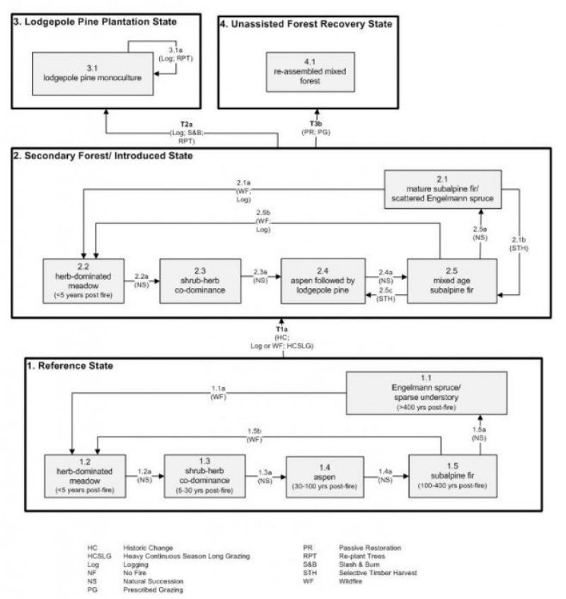
Below is a State and Transition Model diagram to illustrate the “phases” (common plant communities), and “states” (aggregations of those plant communities) that can occur on the site. Differences between phases and states depend primarily upon observations of a range of disturbance histories in areas where this ESD is represented. These situations include tree harvest, grazing gradients to water sources, fence-line contrasts, patches with differing dates of fire, herbicide treatment, tillage, and kinds and times of timber harvest, etc. Reference State 1 illustrates the common plant communities that probably existed just prior to European settlement.
The major successional pathways within states, (“community pathways”) are indicated by arrows between phases. “Transitions” are indicated by arrows between states. The drivers of these changes are indicated in codes decipherable by referring to the legend at the bottom of the page and by reading the detailed narratives that follow the diagram. The transition between Reference State 1 and State 2 is considered irreversible because of the naturalization of exotic species of both flora and fauna, possible extinction of native species, and climate change. There may have also been accelerated soil erosion.
The plant communities shown in this State and Transition Model may not represent every possibility, but are probably the most prevalent and recurring plant communities. As more monitoring data are collected, some phases or states may be revised, removed, and/or new ones may be added. None of these plant communities should necessarily be thought of as “Desired Plant Communities.” According to the USDA NRCS National Range & Pasture Handbook (USDA-NRCS 2003), Desired Plant Communities (DPC’s) will be determined by the decision-makers and will meet minimum quality criteria established by the NRCS. The main purpose for including descriptions of a plant community is to capture the current knowledge at the time of this revision.
State 1 Reference State
The Reference State is a description of this ecological site just prior to Euro-American settlement but long after the arrival of Native Americans. The description of the Reference State was determined by NRCS Soil Survey Type Site Location information and familiarity with rangeland relict areas where they exist. At the time of European colonization, what would have been observed on these sites would have primarily depended on the time elapsed since the last wildfire occurred. Had the site been relatively undisturbed (i.e. without fire) for approximately 400 years or longer, the late seral climax of an Engelmann spruce (Picea engelmannii) -dominated forest would have been found (1.1). The understory would have been relatively sparse due to tree competition, overstory shading, and duff accumulation. Wildfire (1.1a) would have replaced these stands with diverse herb-dominated vegetation (1.2). In the absence of any major disturbance (1.2a, 1.3a, 1.4a, 1.5a), the vegetation would have progressed into more of a shrub-herb co-dominance (1.3), followed by aspen (Populus tremuloides) (1.4), then would have become a mature stand of subalpine fir (Abies lasiocarpa) (1.5). Ultimately the site would have been reinvaded by Engelmann spruce (1.1). A more complete list of species by lifeform for the Reference State is available in accompanying tables in the “Plant Community Composition by Weight and Percentage” section of this document. Wildfire (1.1a, 1.5b) would have been the primary disturbance factor prior to colonization.
Community Phase 1.1: Engelmann spruce/ sparse understory
This plant community (1.1) would have been characterized by a dense-canopied stand of mature Engelmann spruce with a sparse understory of shade-tolerant herbs such as heartleaf arnica (Arnica cordifolia), Geyer’s sedge (Carex geyeri), Ross’ sedge (Carex rossii), and spike trisetum (Trisetum spicatum). This community would have existed approximately 400 years post fire.
Community Pathway 1.1a:
Wildfire would have removed the trees, allowing herbs to flourish briefly.
Community Phase 1.2: herb-dominated meadow
This plant community would have developed within the first 5 years since the last fire. This would have been dominated by shade-intolerant forbs and grasses.
Community Pathway 1.2a:
After about 5 years, shrubs would begin to establish in the site.
Community Phase 1.3: shrub-herb co-dominance
Between 5 and 30 years after fire, shrubs and herbs would co-dominate the site. The Increasing shrub component would have included common juniper (Juniperus communis), grouse whortleberry (Vaccinium scoparium), gooseberry currant (Ribes montigenum), and Oregon boxleaf (Paxistima myrsinites). Geyer’s and Ross’ sedges, spike trisetum, thickspike wheatgrass, heartleaf arnica, and Fendler’s meadow-rue would have been beginning to be present in the understory.
Community Pathway 1.3a:
About 30 years after fire, aspen would have become established in the site.
Community Phase 1.4: aspen
This plant community would have been dominated by aspen, a seral species. Subalpine fir would have been present only as an understory species at this time. Aspen would have dominated these sites for approximately 30 to 100 years following the last fire. The understory would have had a mixture of shrubs and herbaceous species.
Community Pathway 1.4a:
With approximately another century without fire, subalpine fir would have out-competed the aspen to become the dominant overstory species at the site.
Community Phase 1.5: subalpine fir
Subalpine fir would have been temporarily dominant at these sites for approximately 100 to 400 years following the last wildfire. Only shade-tolerant understory species would have been present. During this time, Engelmann spruce would become established in the understory.
Community Pathway 1.5a:
After approximately 400 years following the last wildfire, Engelmann spruce would have out-competed subalpine fir to become the dominant overstory species at the site.
Community Pathway 1.5b:
Wildfire would have removed the trees, allowing shade-intolerant herbs to flourish briefly.
Transition T1a: from State 1 to State 2 (Reference State to Secondary Forest/ Introduced State)
The simultaneous introduction of exotic species, both plants and animals, and possible extinctions of native flora and fauna, along with climate change, has caused State 1 to transition to State 2. Although the earliest use of climax Engelmann spruce forests by Europeans was for trapping of fur beavers, this had little impact on the vegetation. Similarly, early livestock grazing had little impact on these lands in climax forests. Instead, the major European influences were from logging (T1a). The first cycle of logging in these forests was for the large spruce trees for building farms, ranches, and city buildings. Continued impacts could prevent the recovery toward potential conifer dominance (State 2, various phases). Spruce establishment dates back to the colder, wetter little Ice Age, thus it is not likely that the slow growing spruce will re-establish under the altered climate of the present day. The reversal of these changes (i.e. a return pathway) back to State 1 is not practical.
State 2 Secondary Forest/ Introduced State
State 2 is similar to State 1 in form and function, with the exception of the presence of non-native plants and animals, possible extinctions of native species, a different climate, and a secondary stand of trees. State 2 is a description of the ecological site shortly following Euro-American settlement. This state can be regarded as the current potential. With the large spruce trees being targeted during the first rounds of logging, what was left of these trees was minimal to none. Instead, sites that would have been dominated by Engelmann spruce became more often dominated by subalpine fir with only a scattering of Engelmann spruce (2.1). As with the Reference State, time elapsed since last wildfire or logging event remains the key factor in determining what vegetation will be encountered on these sites. Logging effects, along with associated mechanical and fire disturbances, open up the canopy and allow for the expansion of the herbaceous understory (2.1a, 2.5b). In the absence of any major disturbance (2.2a, 2.3a, 2.4a, 2.5a), the vegetation will progress through shrub-herb co-dominance (2.3), followed by aspen and lodgepole pine (Pinus contorta) (2.4), and ultimately by mature subalpine fir (2.1). The resiliency of this State is encouraged by the presence of self-armoring gravelly soils. Livestock grazing and fire exclusion accelerate natural succession of woody species.
Community Phase 2.1: subalpine fir/ scattered Engelmann spruce
This plant community (2.1) is characterized by a stand of mature subalpine fir with a scattering of Engelmann spruce. The understory is sparse and made up of Geyer’s and Ross’ sedges, slender wheatgrass, and heartleaf arnica.
Community Pathway 2.1a:
A stand-replacing wildfire or intensive logging will set the vegetation back to an early seral herb-dominated phase. Logging opens up the forest canopy, allowing shrubs and herbs to flourish for 20 to 30 years.
Community Pathway 2.1b:
Selective timber cutting of mature subalpine fir and remaining Engelmann spruce (i.e. “high grading” - which consists of the harvesting of most valuable trees) will leave a mixed age subalpine fir forest (i.e. “jungled up forest” or “dog-hair stand” - a super dense stand of small trees).
Community Phase 2.2: herb-dominated meadow
This plant community will develop within the first 5 years following the last fire or complete tree removal. The site will be dominated by various shade-intolerant herbs and graminoids and by Fendler’s meadow-rue (Thalictrum fendleri) (Reese 1980). A small component of introduced species may be present.
Community Pathway 2.2a:
Shrubs will become more common and the understory will diminish due to natural succession. Heavy season-long livestock grazing will accelerate woody plant recovery and diminish the understory.
Community Phase 2.3: shrub-herb co-dominance
A plant community co-dominated by shrubs and herbs will develop approximately 5 to 30 years post-fire. A small component of introduced species may be present.
Community Pathway 2.3a:
Woody plant recovery will occur due to natural succession. Heavy season-long sheep grazing, deer and elk grazing, and fire exclusion will accelerate woody plant recovery and diminish the understory.
Community Phase 2.4: aspen followed by lodgepole pine
Aspen will establish in the site 30 to 100 years after the last fire or complete tree removal. Lodgepole pine will become established following aspen.
Community Pathway 2.4a:
Aspen recovery followed by the establishment of lodgepole pine will occur due to natural succession. Heavy season-long livestock grazing and fire exclusion will accelerate woody plant recovery and diminish the understory.
Community Phase 2.5: mixed age subalpine fir
A stand of mature aspen and/or lodgepole pine with an inter-mixing of subalpine fir, white fir (Abies concolor), and Engelmann spruce will develop approximately 100 to 400 years following fire or complete tree removal.
Community Pathway 2.5a:
Through natural succession, subalpine fir will dominate the site 400 years or more years following the last fire or complete tree removal. Fire exclusion will accelerate woody plant recovery and diminish the understory.
Community Pathway 2.5b:
A stand-replacing wildfire or intensive logging will set the vegetation back to an early seral shade-intolerant herb-dominated phase. Logging opens up the forest canopy allowing shrubs and herbs to flourish for 20 to 30 years.
Community Pathway 2.5c:
Selective timber harvest of subalpine fir will allow aspen or lodgepole pine to regain temporary dominance.
Transition T2a: from State 2 to State 3 (Secondary Forest/ Introduced State to Lodgepole Pine Plantation State)
Sites that have had the most intense logging pressure have also had greatest degree of forest soil erosion and soil compaction. Once the forest reaches a certain level of degradation, managers often decide to focus on favoring one tree, usually lodgepole pine because of its greater growth rate and merchantability. This requires a clear cut and slash disposal followed by planting.
Transition T2b: from State 2 to State 4 (Secondary Forest/ Introduced State to Unassisted Forest Recovery State)
A less costly alternative compared to logging/slashing/replanting is to defer logging and control livestock grazing to allow whatever self-regenerating trees that occur on the site to recover. This process could, however, be thwarted by heavy game usage (i.e. elk utilization of aspen, or snowshoe hare utilization of subalpine fir). The Forest Service calls this “passive restoration.” Recovery of Engelmann spruce may not occur if climates continue with current warming trends. The pre-settlement spruce forest establishment may have been a product of the cooler, wetter Little Ice Age (AD 1450-1850).
State 3Lodgepole Pine Plantation State
State 3 is plantation forest of lodgepole pine planted specifically to replace previously degraded forests and to increase productivity of the site for economic profitability. Subsequent harvests and replanting will take place at maximum wood accumulation. Thinning to reduce insect or pathogen outbreaks will help maintain the resiliency of this State. Conversely, no management action may reduce the resiliency of this State.
Community Phase 3.1: lodgepole pine monoculture
This plant community is a monoculture of lodgepole pine managed specifically for growth rate and harvestability.
Community Pathway 3.1a:
Maintenance of the Lodgepole Pine Plantation State requires subsequent harvests at maximum accumulated wood followed by replanting.
State 4 Unassisted Forest Recovery State
This state is achieved through “passive restoration”, allowing whatever self-regenerating trees that occur on the site to recover naturally. Thinning to reduce insect or pathogen outbreaks will help maintain the resiliency of this State. Conversely, no management action may reduce the resiliency of this State.
Community Phase 4.1: re-assembled mixed forest
The trees likely to occur in this phase include aspen and subalpine fir.
Community 1.1
Reference State
a. Nature of Forest Community
The overstory tree canopy cover is about 55 percent. Common understory plants are dwarf blueberry, creeping Oregon grape, Ross sedge, pinegrass, and gooseberry current. Understory composition by air-dry weight is about 20 percent perennial grasses and grasslike plants, 5 percent forbs, and 75 percent shrubs. Understory production ranges from 110 pounds per acre in favorable years to about 90 pounds per acre in unfavorable years. Understory production includes the total annual production of all species within 4 ½ feet of the ground surface.
Table 5. Annual production by plant type
| Plant type |
Low
(lb/acre) |
Representative value
(lb/acre) |
High
(lb/acre) |
| Shrub/Vine |
68 |
75 |
83 |
| Grass/Grasslike |
18 |
20 |
22 |
| Forb |
4 |
5 |
6 |
| Total |
90 |
100 |
111 |