Natural Resources
Conservation Service
Ecological site R048AY007NM
Mountain Shale
Last updated: 3/05/2024
Accessed: 11/23/2024
General information
Provisional. A provisional ecological site description has undergone quality control and quality assurance review. It contains a working state and transition model and enough information to identify the ecological site.

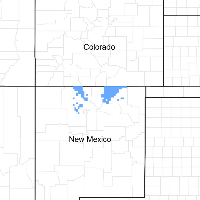
Figure 1. Mapped extent
Areas shown in blue indicate the maximum mapped extent of this ecological site. Other ecological sites likely occur within the highlighted areas. It is also possible for this ecological site to occur outside of highlighted areas if detailed soil survey has not been completed or recently updated.
MLRA notes
Major Land Resource Area (MLRA): 048A–Southern Rocky Mountains
This area is in Colorado (76 percent), New Mexico (11 percent), Utah (8 percent), and Wyoming (5 percent). It makes up about 45,920 square miles (119,000 square kilometers). The towns Jemez Springs, Los Alamos, Red River and Eagle Nest, New Mexico, are in this MLRA. This MLRA has numerous national forests, the Carson National Forest and part of the Santa Fe National Forest in New Mexico. The Jemez, Picuris, Santa Clara, and Taos Indian Reservations are in this MLRA. Most of this area is in the Southern Rocky Mountains Province of the Rocky Mountain System. Small parts of the southwest corner and some isolated areas farther west are in the Canyon Lands Section of the same province and division. The Southern Rocky Mountains consist primarily of two belts of strongly sloping to precipitous mountain ranges trending north to south. Several basins, or parks, are between the belts. The ranges include the Sangre de Cristo Mountains, Jemez Mountains, and Tusas Mountains. Elevation typically ranges from 6,500 to 13,167 feet (1,980 to 1,039 meters) in this area. The Rio Grande is a National Wild and Scenic River in northern New Mexico, which is in the southern part of this MLRA.
The mountains in this area were formed mainly by crustal uplifts during the late Cretaceous and early Tertiary periods. The rocks exposed in the mountains are mostly Precambrian igneous and metamorphic rocks, which in many places are flanked by steeply dipping Mesozoic sedimentary rocks. Younger igneous rocks, primarily basalt and andesitic lava flows, tuffs, breccias, and conglomerates, are throughout this area. Representative formations in this area are the Silver Plume and Pikes Peak granites, San Juan Volcanics, and Mancos Shale. Many of the highest mountain ranges were reshaped by glaciation during the Pleistocene. Alluvial fans at the base of the mountains are recharge zones for local basin and valley fill aquifers. They also are important sources of sand and gravel.
The dominant soil orders in this MLRA are Mollisols, Alfisols, Inceptisols, and Entisols. The soils in the area dominantly have a frigid or cryic soil temperature regime and an ustic or udic soil moisture regime. Mineralogy is typically mixed, smectitic, or paramicaceous. In areas with granite, gneiss, and schist bedrock, Glossocryalfs (Seitz, Granile, and Leadville series) and Haplocryolls (Rogert series) formed in colluvium on mountain slopes. Dystrocryepts (Leighcan and Mummy series) formed on mountain slopes and summits at the higher elevations. In areas of andesite and rhyolite bedrock, Dystrocryepts (Endlich and Whitecross series) formed in colluvium on mountain slopes. In areas of sedimentary bedrock, Haplustolls (Towave series) formed on mountain slopes at low elevations and with low precipitation. Haplocryolls (Lamphier and Razorba series), Argicryolls (Cochetopa series), and Haplocryalfs (Needleton series) formed in colluvium on mountain slopes at high elevations.
LRU notes
This site is part of the RM-1 sub-resource area. This site is found on the east side of Sangre de Cristo mountains.
Classification relationships
This ecological site is correlated to soil components at the Major Land Resource Area (MLRA) level which is further described in USDA AgHandbook 296.
Ecological site concept
This site is located in mountainous terrain on mountain slopes and hillslopes. Slopes are dominantly moderately steep to steep with gradients varying from 15 to 75 percent. Topography varies from relatively uniform slopes of considerable length to short, steep, choppy terrain. Elevation ranges from 7,000 to 9,000 feet above sea level.
This site consists of soils that are shallow to moderately deep and are well drained. The surface texture is very stony clay, very stony clay loam, cobbly loam, and stony silty clay loam soils. The soils are derived from shale parent material. The effective rooting depth is 5 to 40 inches. Shale and sandstone outcrops are common. The subsoil is typically compacted clay, which restricts root penetration.
Associated sites
| R048AY004NM |
Mountain Loam This site is on steep to moderately steep slopes on benches within the steeper slopes of the surrounding ponderosa pine tree zone. The slope is to the southwest; south and southeast, making the site directly exposed to the dry south and southwest winds and more intensive heat from the sun. Slopes vary from 5 to 70 percent. Elevation ranges from 6,900 to 9,000 feet above sea level. The soils on this site are moderately deep to deep and well drained. The surface texture is stony/cobbly silt loam or cobbly loam. The subsurface is stony loam or cobbly loam. They have a moderate permeability. The available water-holding capacity is low. Effective rooting depth is from 20 to 40 inches. There is cobble or stone throughout the profile and on the surface. Air-water-plant relationship is fair. |
|---|---|
| R048AY003NM |
Mountain Valley This site is in mountain valleys in the ponderosa pine zone. It has gentle to moderate slopes and receives occasional light overflow from the stream course or adjacent side slopes. The alluvial slopes immediately adjacent to the stream are also included in this site. Slopes are 0-5%. Along valley bottoms where drainage is poor, it may blend with the Mountain Meadow ecological site. This site differs from the Mountain Meadow ecological site in the lack of high-water table. Elevation ranges from 7,000 to 9,000 feet above sea level. Soils on this site are well drained and deep to very deep. The surface layer is loam, sandy loam or fine sandy loam with subsoil of loam, clay loam, or sandy clay loam. These soils have moderate to moderately high permeability. Runoff is medium. Available water-holding capacity is high. Effective rooting depth is 20 inches to more than 60 inches. Severe gullying can carry off most of the water, and a loss of topsoil greatly reduces water intake. Gullies that carry off extra water will drastically alter the moisture-plant relationship in many areas. |
Similar sites
| R048AY008NM |
Mountain Brush This site is located on the sides of basalt-capped mesas and escarpments of sandstone, basalt, shale and limestone. This site is formed on the upland leading away from vertical basalt escarpments and basalt-capped mesas. They are formed from a variety of materials derived from sandstone, basalt, shale and limestone. Rock outcrop is common and may occupy from 15 percent to 50 percent of the area. Slopes range from 5 to 25 percent. The exposure is mainly to the east, south and west. However, this site may occur on the drier north-facing slopes. North and east-facing slopes are generally more productive and tend to grow more woody vegetation. Elevation ranges from 7,500 to 9,000 feet above sea level. The soils on this site are shallow, well drained over sandstone, shale, basalt and limestone. Rock outcrops are common and occupy the nearly vertical basalt escarpments, ridges and benches of exposed sandstone, limestone and shale. Rubbleland occurs at the base of the basalt escarpments. The surface textures is usually clay loam and the subsoils are clay loam and clayey shale. The surface runoff is medium too rapid and the erosion hazard is severe. Effective rooting depth is from 12 to 20 inches. |
|---|---|
| R048AY009NM |
Mountain Breaks This site occurs on mesa and canyon side-slopes and other mountain breaks. The site consists of productive areas interspersed with areas of low production, rock outcrop and badland. Slopes and exposure vary. Slopes range from 9 to 45 percent. Elevation ranges from 9,100 to 10,500 feet above sea level. Soil depths is deep. Surface texture is generally a gravelly loam. Subsoils range from gravelly clay loam, gravelly sandy clay loam to very gravelly sandy clay loam. The soil profile is generally high in rock fragments. Boulders are scattered about the site. There usually are pockets on the site where run-in of precipitation results in good soil-moisture relationships. Occurs in RM-2. |
| R048AY015NM |
Mountain Shale Dry This site occurs on nearly level to sloping landscapes below steeper slopes of interbedded sandstone and shale. Slopes range from 1 to 35 percent. Elevation ranges from 6,800 to 7,700 feet above sea level. Soil depths range from shallow to moderately deep. Surface textures are generally clay loam and are very thin. Subsoils are generally clays. The amount of surface skeletal fragments varies from no fragments to very channery and erosion pavement forms as the surface is eroded. Permeability is slow to very slow. This ecological site used to have the ID number of R048BY008NM in RM-2 subresource area in 1982. |
Table 1. Dominant plant species
| Tree |
(1) Juniperus scopulorum |
|---|---|
| Shrub |
(1) Cercocarpus montanus |
| Herbaceous |
(1) Bouteloua gracilis |
Click on box and path labels to scroll to the respective text.
