Natural Resources
Conservation Service
Ecological site R048AY011NM
Subalpine Grassland Dry
Last updated: 4/03/2025
Accessed: 02/09/2026
General information
Provisional. A provisional ecological site description has undergone quality control and quality assurance review. It contains a working state and transition model and enough information to identify the ecological site.

Figure 1. Mapped extent
Areas shown in blue indicate the maximum mapped extent of this ecological site. Other ecological sites likely occur within the highlighted areas. It is also possible for this ecological site to occur outside of highlighted areas if detailed soil survey has not been completed or recently updated.
MLRA notes
Major Land Resource Area (MLRA): 048A–Southern Rocky Mountains
This area is in Colorado (76 percent), New Mexico (11 percent), Utah (8 percent), and Wyoming (5 percent). It makes up about 45,920 square miles (119,000 square kilometers). The towns Jemez Springs, Los Alamos, Red River and Eagle Nest, New Mexico, are in this MLRA. This MLRA has numerous national forests, the Carson National Forest and part of the Santa Fe National Forest in New Mexico. The Jemez, Picuris, Santa Clara, and Taos Indian Reservations are in this MLRA. Most of this area is in the Southern Rocky Mountains Province of the Rocky Mountain System. Small parts of the southwest corner and some isolated areas farther west are in the Canyon Lands Section of the same province and division. The Southern Rocky Mountains consist primarily of two belts of strongly sloping to precipitous mountain ranges trending north to south. Several basins, or parks, are between the belts. The ranges include the Sangre de Cristo Mountains, Jemez Mountains, and Tusas Mountains. Elevation typically ranges from 6,500 to 13,167 feet (1,980 to 1,039 meters) in this area. The Rio Grande is a National Wild and Scenic River in northern New Mexico, which is in the southern part of this MLRA.
The mountains in this area were formed mainly by crustal uplifts during the late Cretaceous and early Tertiary periods. The rocks exposed in the mountains are mostly Precambrian igneous and metamorphic rocks, which in many places are flanked by steeply dipping Mesozoic sedimentary rocks. Younger igneous rocks, primarily basalt and andesitic lava flows, tuffs, breccias, and conglomerates, are throughout this area. Representative formations in this area are the Silver Plume and Pikes Peak granites, San Juan Volcanics, and Mancos Shale. Many of the highest mountain ranges were reshaped by glaciation during the Pleistocene. Alluvial fans at the base of the mountains are recharge zones for local basin and valley fill aquifers. They also are important sources of sand and gravel.
The dominant soil orders in this MLRA are Mollisols, Alfisols, Inceptisols, and Entisols. The soils in the area dominantly have a frigid or cryic soil temperature regime and an ustic or udic soil moisture regime. Mineralogy is typically mixed, smectitic, or paramicaceous. In areas with granite, gneiss, and schist bedrock, Glossocryalfs (Seitz, Granile, and Leadville series) and Haplocryolls (Rogert series) formed in colluvium on mountain slopes. Dystrocryepts (Leighcan and Mummy series) formed on mountain slopes and summits at the higher elevations. In areas of andesite and rhyolite bedrock, Dystrocryepts (Endlich and Whitecross series) formed in colluvium on mountain slopes. In areas of sedimentary bedrock, Haplustolls (Towave series) formed on mountain slopes at low elevations and with low precipitation. Haplocryolls (Lamphier and Razorba series), Argicryolls (Cochetopa series), and Haplocryalfs (Needleton series) formed in colluvium on mountain slopes at high elevations.
LRU notes
This site is part of the RM-2 sub-resource area. This site is found on the west side of Sangre de Cristo mountains, Tusas Mountains (southern San Juan mountains) and Jemez Mountains.
Classification relationships
This ecological site is correlated to soil components at the Major Land Resource Area (MLRA) level which is further described in USDA AgHandbook 296.
Ecological site concept
This site occurs on high mountain tops above and extending down into parks within the spruce-fir zone. Aspen groves and colonies of Gambel oak may be scattered throughout the site. The landscape ranges from rolling to steep with side slopes ranging from 5 to 45 percent. Elevation ranges from 9,000 to 12,000 feet above sea level.
The soils are deep but may be high in surface cobbles and stones and give the impression of being shallow. Surface textures range from cobbly and/or gravelly loams and very cobbly sandy loam. Subsoils textures range from loam, clay loam and silt loams are are filled with rock fragments. Family particle size class is loamy-skeletal.
This ecological site used to have the ID number of R048BY003NM in RM-2 subresource area in 1982.
Associated sites
| R048AY014NM |
Mountain Valley Dry This site occurs on broad valleys, overflow areas adjacent to intermittent streams and depressional areas subject to run-in of moisture from adjacent sites. However, this site is often highly dissected, and run-in is non-effective. Slopes range from 1 to 8 percent. Elevation ranges from 7,200 to 8,000 feet above sea level. The soils are deep to very deep and well drained. Surface textures is usually clay loam. Subsoils is usually clay. This ecological site used to have the ID number of R048BY007NM in RM-2 subresource area in 1982. |
|---|---|
| F048AY908CO |
Mixed Conifer This site is found mostly commonly on mountain slopes. Soils are moderately deep to very deep (20 to 60+ inches). Soil surface textures are loam, very gravelly sandy loam, very stony sandy loam, stony sandy loam, stony loam, very stony loam, very cobbly loam or gravelly fine sandy loam. Subsurface textures can be loamy-skeletal or sometimes fine-loamy. It is usually ustic udic or typic udic and cryic. It is a Mixed Conifer community with subalpine fir, white fir, and Douglas fir intermixed. The effective precipitation ranges from 20 to 40 inches. |
Similar sites
| R048AY250CO |
Subalpine Loam This site occurs on hills, mountain-slopes, and mountains. Slopes is between 1 to 30%. Soils are deep to very deep (20 to 60+ inches). Soils are derived from colluvium and alluvium from volcanic rock; complex landslide deposits from igneous, metamorphic, and sedimentary rock; and slope alluvium, colluvium, residuum, alluvium or complex landslide deposits from sandstone and shale or shale. Soil surface texture is loam with loamy textured subsurface. It is a mountain big sagebrush – Thurber’s Fescue community. It has an ustic udic/typic udic moisture regime and cryic temperature regime. The effective precipitation ranges from 20 to 30 inches. |
|---|---|
| R048AY001NM |
Subalpine Grassland This site takes in mountain parks and other open grasslands generally within the spruce-fir zone. In some places it is interspersed with aspen groves. This site is located near timberline extending down to the ponderosa pine zone. Topography is mostly rolling to moderate slopes, but some areas are steep. Slopes are between 2 to 20 percent, but can range up to 40 percent. Elevation ranges from 9,000 feet to near timberline, which is approximately 11,400 feet above sea level. The soils are well drained, deep to very deep. The surface texture is loam, cobbly loam or gravelly loam. There may be large numbers of rock fragments throughout the profile as this soil has multiple soil family particle sizes correlated to it. The soils have moderate to moderately slow permeability. Runoff is moderate. Available water-holding capacity is low to medium. The effective rooting depth is 20 inches or more. On the soil Hillery which is correlated to this site, it occurs on lava flows, mesas and plains. Hillery is also above 40 inches of precipitation which is higher than the concept of this site. Surface soil textures are silt loam, and stony loam. |
Table 1. Dominant plant species
| Tree |
Not specified |
|---|---|
| Shrub |
Not specified |
| Herbaceous |
(1) Festuca arizonica |
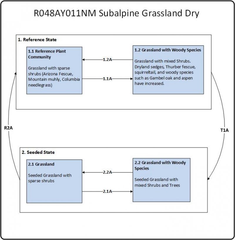
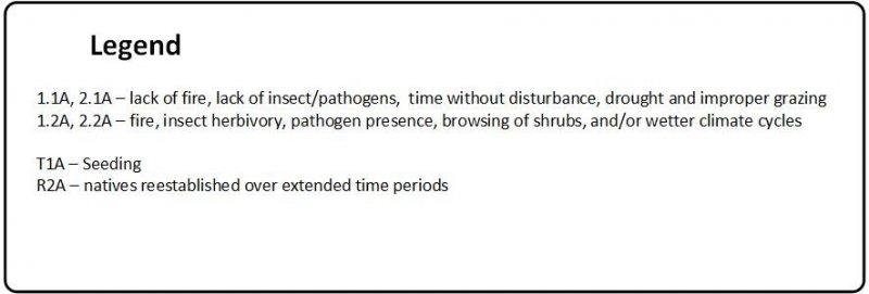
Click on box and path labels to scroll to the respective text.


