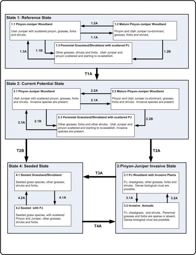
Ecological dynamics
State 1: Reference State
This state represents the natural variability and dynamics of this site that occurred naturally. This state includes the dominant biotic communities that would have occurred on this ecological site prior to European Settlement. The dominant aspect of this site is Pinyon and Utah Juniper with an understory of shrubs and associated grasses. Fluctuations in species compositions and relative production may change from year to year dependent upon abnormal precipitation or other climatic factors. The primary disturbance mechanisms for this site in reference condition include drought, insects, and infrequent fire. Because catastrophic disturbances like a crown fire or drought happen with long intervals, these communities have long periods of succession, (i.e. long periods of dense Pinyon and Juniper)—300-600 years in upland/foothills ecological site zone and 300 to 1,000 in semi-desert ecological site zone. Typically, fires occurred in late spring through mid-summer following several wet years that allowed the fine fuels to become more contiguous. The higher in elevation and higher precipitation area would burn more frequently as they would have more fine fuels in the understory. The timing of drought, and fire, coupled with surface disturbance can dictate whether the community can stay within the reference state or if the community transitions into another state.
When this site is at or near it's potential, pinyon pine and Utah juniper dominate the site and make up over 80 percent of the plant community. Understory production is very limited and provides marginal amounts of forage for livestock and or wildlife. It does provide good escape cover and thermal cover for deer. When the tree canopy cover exceeds 30 percent, diversity, both plant and animal drops to its lowest level.
Community Phase 1.1: Pinyon-Juniper Woodland
A well-developed understory with a canopy of younger pinyon and Utah juniper. At this stage Utah juniper may be dominant over pinyon. Pinyon trees are more susceptible to drought, insects, and disease than Utah juniper trees. In fact, it is difficult to identify methods beside fire that naturally reduce Utah juniper. After long periods of drought weaken the pinyon trees, beetle kills can become quite extensive, especially after the droughts. Drought periods can also weaken and reduce the understory. Plant establishment is mainly limited by the available moisture. Biological crusts can be highly developed and diversified in the large interspaces between trees.
When the tree canopy ranges from 15 to 30 percent, a wide variety of grasses, forbs, and shrubs will also be present in addition to the pinyon pine and Utah juniper. During this tree canopy stage, diversity of plant and animal species will reach its peak.
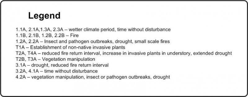
Community Phase Pathway 1.1A
This pathway occurs when events create a wetter climate cycle, favor pinyon and perennial bunch grass establishment. Following several favorable precipitation years and lack of surface disturbances, native perennial plants will reestablish.
Community Phase Pathway 1.1B
This pathway is very unlikely but can occur when a fire is able to move through the community. Two situations can make this occur: 1) a fire can carry in the understory after several wet years allow fine fuels to accumulate, or 2) as the woodland approaches the later stages of development where canopies become dense and crown sizes have increased, and thus community phase becomes susceptible to crown fires.
Community Phase 1.2: Mature Pinyon-Juniper Woodland
Mature pinyon and Utah juniper woodland characterized this community phase. When weather patterns favor an increase of pinyon and Utah juniper canopy with the associated understory of shrubs, grasses and forbs. Depending on the timing of precipitation, cool season grasses, or warm season grasses could be dominant. Interspaces supporting highly developed biological crusts are
common.
Community Phase Pathway 1.2A
This pathway occurs during and after events such as drought or insect/pathogen outbreaks. Droughts and insects can kill the trees, increasing nutrient availability in the system. Due to the natural conditions of drought, grasses typically do not take up the extra nutrients in the long term. In the short term, grasses and forbs may increase for a few years until juniper and pinyon recover.
Community Phase Pathway 1.2B
This pathway is very unlikely but can occur when a fire is able to move through the community phase. Two situations can make this occur: 1) a fire can carry in the understory after several wet years allow fine fuels to accumulate, or 2) as the woodland approaches the later stages of development where canopies become dense and crown sizes have increased, and thus community phase becomes susceptible to crown fires.
Community Phase 1.3: Perennial Grassland/Shrubland with scattered PJ
The overall aspect of this community phase is grasses and shrubs with scattered pinyon and Utah juniper. The herbaceous understory has a mix of grasses and forbs. This community phase is a result of a crown fire or sufficiently large and hot ground fire that will kill many of the trees, combined with sufficient seed-banks and moisture for reestablishment of grasses and forbs. It is common that after a crown fire many patches of trees will remain unburned, because of fire’s unpredictability and broken topography. This leaves a seed bank for the burned areas. This community phase is very short lived in comparison to the other community phases in this state.
When the tree canopy ranges from 0 - 15 percent; grasses, forbs, and shrubs will produce approximately 80 to 90 percent of the total production. When the tree canopy level is reduced by fire, chaining and/or application of herbicides, forage production will be at its highest level for big game animals as well as domestic livestock.
Community Phase Pathway 1.3A
This pathway occurs when the climate favors the establishment and growth of trees. More energy is taken-up and stored in the trees as the length between fires and droughts increase. In addition, when shrubs establish on the site they can provide safe-sites for tree establishment furthering the presence of trees.
Transition T1A
This transition from the native perennial bunchgrass and shrub understory in the reference state to a state that has been invaded by naturalized species such as crested wheatgrass (blown in or seeded), cheatgrass, annual wheatgrass and other introduced or exotic plants. This transition occurs as natural and/or management actions favor an increase in non-native grasses and forbs, especially annuals. Possible events include the presence of invasive species, improper livestock grazing, extended droughts, and fire combined with an available seed source of non-native species.
State 2: Current Potential State
This state is very similar to the reference state, except that non-native grasses and/or forbs are now present in all community phases. The current potential state may include introduced (seeded) or invasive nonnative species. The invasive plants are present in sparse amounts in this state. Natural disturbance are still drought, insects, and infrequent fires still influence the community shifts. The human caused disturbance drivers (i.e. domestic livestock grazing, vegetation manipulation, and recreational activities (i.e. OHV use)) are now present. This shift in species composition could affect nutrient cycling, hydrology and soil stability. At this time there is no known way to effectively remove the non-native plants from the site once they have become established. State 2 is in jeopardy of moving to State 3 (Pinyon-Juniper Invasive State) when remaining native understory plants are stressed and invasive species have increased till they are dominant.
Community Phase 2.1: Pinyon-Juniper Woodland
A well-developed understory with a canopy of younger Pinyon and Utah juniper. At this stage Utah juniper may be dominant over Pinyon. Pinyon trees are more susceptible to drought, insects, and disease than Utah Juniper trees. In fact, it is difficult to identify methods beside fire that naturally reduce Utah juniper. After long periods of drought weaken the Pinyon trees, beetle kills can become quite extensive, especially after the droughts. Drought periods can also weaken and reduce the understory. Plant establishment is mainly limited by the available moisture. Biological crusts can be highly developed and diversified in the large interspaces between trees. Sparse invasive introduced plants species would be present in this phase.
Community Phase Pathway 2.1A
This pathway occurs when events create a wetter climate cycle, favor Pinyon and perennial bunch grass establishment. Following several favorable precipitation years and lack of surface disturbances, native perennial bunch grasses and forbs will reestablish.
Community Phase Pathway 2.1B
This pathway is very unlikely but can occur when a fire or vegetation manipulation happens to the trees. Two situations can make this occur: 1) a fire can carry in the understory after several wet years allow fine fuels to accumulate, or 2) as the woodland approaches the later stages of development where canopies become dense and crown sizes have increased, and thus community phase becomes susceptible to crown fires. Seeding after the tree removal may be necessary to help facilitate the return of understory species. Seeding depending on the species may take this community phase into state 4 (Seeded State).
Community Phase 2.2: Mature Pinyon-Juniper Woodland
Mature pinyon and Utah juniper woodland with a well-developed understory would characterized this community phase. This phase supports a diverse understory of grasses, forbs and shrubs. Depending on the timing of precipitation, cool season grasses, or warm season grassescould be dominant. Interspaces supporting highly developed biological crusts are common. Sparse invasive introduced plants species would be present in this phase.
Community Phase Pathway 2.2A
This pathway occurs during and after events such as drought or beetle infestations. Droughts and insects can kill pinyon trees, increasing nutrient availability in the system. Due to the natural conditions of drought, grasses typically do not take up the extra nutrients in the long term. In the short term, grasses and forbs may increase for a few years until Juniper recover. Utah Juniper are more able to compete for these nutrients and became the dominant overstory tree over time.
Community Phase Pathway 2.2B
This pathway is very unlikely to occur naturally with fire. But, vegetation manipulation can be used to remove trees. Two situations occur naturally: 1) a fire can carry in the understory after several wet years allow fine fuels to accumulate, or 2) as the woodland approaches the later stages of development where canopies become dense and crown sizes have increased, and thus community phase becomes susceptible to crown fires. Seeding after the tree removal may be necessary to help facilitate the return of understory species. Seeding depending on the species may take this community phase into state 4 (Seeded State).
Community Phase 2.3: Perennial Grassland/Shrubland with scattered PJ
The overall aspect of this community phase is grassland with scattered pinyon and Utah juniper. The herbaceous understory has a mix of grasses and forbs. This community phase is a result of a crown fire or sufficiently large and hot ground fire that will kill many of the trees, combined with sufficient seed-banks and moisture for reestablishment of grasses and forbs. It is common that after a crown fire many patches of trees will remain unburned, because of fire’s unpredictability and broken topography. This leaves a seed bank for the burned areas. This community phase is very short lived in comparison to the other community phases in this state. Sparse invasive introduced plants species would be present in this phase.
Community Phase Pathway 2.3A
This pathway occurs when the climate favors the establishment and growth of trees. More energy is taken-up and stored in the trees as the length between fires and droughts increase. In addition, when shrubs establish on the site they can provide safe-sites for tree establishment furthering the presence of trees.
Transition T2A
When this transition to state 3 occurs the site has lost much of its expected resistance and resilience. At this point natural and/or management actions have decreased the understory to a point where erosion increases. Reduced influence from fire, insects, and drought could cause the tree canopy to close, effectively reducing the herbaceous understory thus facilitating the transition. Improper grazing and or increase surface disturbance combined with periods of drought can facilitate this transition because soil stability is lost and susceptibility to soil loss increases.
Transition T2B
This transition is from tree canopy reduction and re-establishment of grasses and forbs. If the community is approaching state 3 (pinyon juniper invasive state), due to a loss of understory and increase invasive plants this pathway of seeding could be preferable to doing nothing. This pathway may facilitate the recovery of the soils. The infrequent naturally occurring fires could also cause this transition. Reseeding after a fire may be the only way to successfully restore the ecological dynamics to a site. Either way this pathway involves large energy and monetary inputs by man.
State 3: Pinyon-Juniper Invasive State
This state occurs when there is an absence of natural disturbance (i.e. Insects and drought and/or fire) over long time frames. Also, management actions could have allowed trees to become very mature and have effectively closed out the understory. Invasive plants have increased in abundance. This state has the lowest resiliency and resistance of any state in this model. There may be no practicable way back to the Current Potential State (State 2), due to the large amounts of energy and monetary inputs that are needed. Seeding, with either natural disturbance and/or vegetation management to transition it to State 3 (Seeded State) may be the best long term option for this site.
Community Phase 3.1: PJ Woodland with Invasive Plants
A lack of understory with a canopy of older Pinyon and Juniper, where plant interspaces very large and connected. This community phase occurs when natural or management actions allow for the increase in Pinyon and Utah juniper and a decrease in the grass and forb understory. Invasive introduced plants species would be present in this phase and are increasing.
Community Phase Pathway 3.1A
This pathway occurs when events such as frequent fire or drought remove the trees and shrubs, and facilitate the continued establishment of cheatgrass or other invasive annuals. Cheatgrass will typically invade/increase in tree/shrub interspaces when PJ communities are degraded. Once the cheatgrass establishes the amount and continuity of fine fuels increases. This can reduce the fire return interval and shorten the time between fires. When fire eliminates the tree/shrub/native grass component, it completes the conversion to annual dominant community phase. Cheatgrass and other invasive annuals can persist for long periods of time. Once a fire or a drought removes the trees/shrubs, it is difficult to reestablish because, not only has the fire return interval been shortened to a time that will not allow seedling establish, the soil and other abiotic factors have been altered.
Community Phase 3.2: Invasive Annuals
This state is characterized by annual grasses like cheatgrass, annual wheatgrass dominating the understory. Also, invasive forbs like storkbill, halogeton and others may be present. This community phase has active erosion under the pinyon and Utah juniper canopy. Utah Juniper has allelopathic effects on some plant (i.e. Sandberg bluegrass, blue grama).
Community Phase Pathway 3.2A
This pathway is when there is a lack of fire and/or disturbance. The fire return interval lengthens. This could be done by having firebreaks and/or fire suppression which will allow the perennial species a chance to establish with natural processes or with vegetation manipulation.
Transition T3A
Vegetation treatment can transition it to a seeded state. Because of the soils (shallow and/or rocky) and the unpredictable precipitation, this pathway should be used cautiously. This pathway involves large energy and monetary inputs by man.
State 4: Seeded State
This state is a result seeding plants species. Vegetation manipulation may or may not have been done depending on disturbance history of the location. The trees were removed and adapted grasses, forbs and shrubs are established. Plants can be native or introduced depending on the desired management goals. If grazing tolerant species were established these communities can better withstand grazing and other disturbances. Due to the shallow or rocky soils and unpredictable precipitations patterns, it is difficult to establish grasses from seed, so this state may be hard to achieve and require large energy inputs.
Community Phase 4.1: Seeded Grassland/Shrubland
This community phase appears as a grassland with scattered shrubs and trees. The vegetative production is typically higher than in the current potential state, depending on grass species seeded; however the grass is still sparse due to the low water holding capacity of soils associated with pinyon and juniper.
Community Phase Pathway 4.1A
This pathway occurs when events favor the establishment of shrubs and trees, including long periods without disturbances.
Community Phase 4.2: Seeded with PJ
This community phase has a dense under story of introduced grasses and forbs, but a canopy of pinyon and Utah juniper are establishing. Native perennial grasses, forbs, and shrubs may also be starting to establish. Interspaces are filled with biological crusts and herbaceous plants.
Community Phase Pathway 4.2A
This pathway occurs as trees and shrubs are removed from the community, either naturally through insect herbivory or through vegetation manipulation by man.
Transition T4A
This transition occurs when events favor the establishment and dominance of invasive annuals. Events may include an extended drought, surface disturbance such as off road vehicle use, and/or a shortened fire return interval, all of which can stress the native perennial bunchgrasses.
State 1
Reference
As ecological condition deteriorates due to anthropogenic disturbances and/or the alteration of the natural disturbance regime, native perennial bunch grasses decrease while pinyon and juniper increase. When the potential natural plant community is burned and/or drought conditions persist, pinyon and juniper decrease while native perennial bunch grasses increase.
Community 1.1
Reference Plant Community
The general view of this site is Utah juniper and pinyon with an understory of birchleaf mountainmahogany and Salina wildrye. The composition by air-dry weight is approximately 15 percent trees, 40 percent grasses, 10 percent forbs, and 35 percent shrubs.
Table 5. Annual production by plant type
| Plant type |
Low
(lb/acre) |
Representative value
(lb/acre) |
High
(lb/acre) |
| Grass/Grasslike |
60 |
140 |
220 |
| Shrub/Vine |
52 |
122 |
192 |
| Tree |
23 |
53 |
83 |
| Forb |
15 |
35 |
55 |
| Total |
150 |
350 |
550 |
Table 6. Ground cover
| Tree foliar cover |
14-16%
|
| Shrub/vine/liana foliar cover |
19-21%
|
| Grass/grasslike foliar cover |
19-21%
|
| Forb foliar cover |
4-6%
|
| Non-vascular plants |
0%
|
| Biological crusts |
0%
|
| Litter |
0%
|
| Surface fragments >0.25" and <=3" |
0%
|
| Surface fragments >3" |
0%
|
| Bedrock |
0%
|
| Water |
0%
|
| Bare ground |
0%
|
Table 7. Canopy structure (% cover)
| Height Above Ground (ft) |
Tree |
Shrub/Vine |
Grass/
Grasslike |
Forb |
| <0.5 |
– |
– |
– |
– |
| >0.5 <= 1 |
– |
– |
– |
4-6% |
| >1 <= 2 |
– |
– |
19-21% |
– |
| >2 <= 4.5 |
– |
19-21% |
– |
– |
| >4.5 <= 13 |
14-16% |
– |
– |
– |
| >13 <= 40 |
– |
– |
– |
– |
| >40 <= 80 |
– |
– |
– |
– |
| >80 <= 120 |
– |
– |
– |
– |
| >120 |
– |
– |
– |
– |