Provisional. A provisional ecological site description has undergone quality control and quality assurance review. It contains a working state and transition model and enough information to identify the ecological site.
Areas shown in blue indicate the maximum mapped extent of this ecological site. Other ecological sites likely occur within the highlighted areas. It is also possible for this ecological site to occur outside of highlighted areas if detailed soil survey has not been completed or recently updated.
MLRA notes
Major Land Resource Area (MLRA): 048A–Southern Rocky Mountains
MLRA 48A makes up about 45,920 square miles (119,000 square kilometers) and is the southern part of the Rocky Mountains. The Southern Rocky Mountains lies east of the Colorado Plateau, south of the Wyoming Basin, west of the Great Plains, and north of the Rio Grande Rift. It is in western and central Colorado, southeastern Wyoming, eastern Utah, and northern New Mexico. The headwaters of major rivers such as the Colorado, Yampa, Arkansas, Rio Grande, North Platte and South Plate rivers are located here. This MLRA has numerous national forests, including the Medicine Bow National Forest in Wyoming; the Routt, Arapaho, Roosevelt, Pike, San Isabel, White River, Gunnison, Grand Mesa, Uncompahgre, Rio Grande, and San Juan National Forests in Colorado; the Carson National Forest and part of the Santa Fe National Forest in New Mexico. Rocky Mountain National Park also is in this MLRA.
MLRA 48A is the southern Rocky Mountains physiographic region. The Southern Rocky Mountains consist primarily of two belts of strongly sloping to precipitous mountain ranges trending north to south. Several basins, or parks, are between the belts. Some high mesas and plateaus are included. It is characterized by mountain ranges that were uplifted during the Laramide Orogeny and then had periods of glaciation. The ranges include the Sangre de Cristo Mountains, the Laramie Mountains, and the Front Range in the east and the San Juan Mountains and the Sawatch and Park Ranges in the west. The ranges are dissected by many narrow stream valleys having steep gradients. In some areas the upper mountain slopes and broad crests are covered by snowfields and glaciers. Elevation typically ranges from 6,500 to 14,400 feet (1,980 to 4,390 meters) in this area. The part of this MLRA in central Colorado includes the highest point in the Rockies, Mount Elbert, which reaches an elevation of 14,433 feet (4,400 meters). More than 50 peaks in the part of the MLRA in Colorado are at an elevation of more than 14,000 feet (4,270 meters). Many small glacial lakes are in the high mountains.
The mountains in this area were formed mainly by crustal uplifts during the late Cretaceous and early Tertiary periods. This large MLRA can be subdivided into at least 4 large general divisions. First is the Rockies on the east side of this area are called the “Front Range,” which is a fault block that has been tilted up on edge and uplifted and is largely igneous and metamorphic geology. It was tilted up on the east edge, so there is a steep front on the east and the west side is more gently sloping and in the south east there are rocks exposed in the mountains are mostly Precambrian igneous and metamorphic rocks. Second is the tertiary rocks, primarily basalt and andesitic lava flows, tuffs, breccias, and conglomerates, are throughout this area (San Juan Mountains Area). The third division is Northwest part of the MLRA is dominantly sedimentary rock from the cretaceous/tertiary and Permian/ Pennsylvanian periods. The fourth subset is the long and narrow Sangre de Cristos mountains uplifted in the Cenozoic are between the Rio Grande rift and the great plains. Many of the highest mountain ranges were reshaped by glaciation during the Pleistocene. Alluvial fans at the base of the mountains are recharge zones for local basin and valley fill aquifers. They also are important sources of sand and gravel.
The average annual precipitation ranges predominantly from 12 to 63 inches. Summer rainfall commonly occurs as high-intensity, convective thunderstorms. About half of the annual precipitation occurs as snow in winter; this proportion increases with elevation. In the mountains, deep snowpacks accumulate throughout the winter and generally persist into spring or early summer, depending on elevation. Some permanent snowfields and small glaciers are on the highest mountain peaks. In the valleys at the lower elevations, snowfall is lighter and snowpacks can be intermittent. The average annual temperature is 26 to 54 degrees F (-3 to 12 degrees C). The freeze-free period averages 135 days and ranges from 45 to 230 days, decreasing in length with elevation. The climate of this area is strongly dependent upon elevation; precipitation is greater, and temperatures are cooler at the higher elevations. The plant communities vary with elevation, aspect and change in latitudes due to changing in precipitation kind and timing and temperature.
The dominant soil orders in this MLRA are Mollisols, Alfisols, Inceptisols, and Entisols. The soils in the area dominantly have a frigid or cryic soil temperature regime and an ustic or udic soil moisture regime. Mineralogy is typically mixed, smectitic, or paramicaceous. In areas with granite, gneiss, and schist bedrock, Glossocryalfs (Seitz, Granile, and Leadville series) and Haplocryolls (Rogert series) formed in colluvium on mountain slopes. Dystrocryepts (Leighcan and Mummy series) formed on mountain slopes and summits at the higher elevations. In areas of andesite and rhyolite bedrock, Dystrocryepts (Endlich and Whitecross series) formed in colluvium on mountain slopes. In areas of sedimentary bedrock, Haplustolls (Towave series) formed on mountain slopes at low elevations and with low precipitation. Haplocryolls (Lamphier and Razorba series), Argicryolls (Cochetopa series), and Haplocryalfs (Needleton series) formed in colluvium on mountain slopes at high elevations.
Ecological site concept
The soils of this site formed mostly in alluvium and/or colluvium derived from sandstone and shale. Surface soils are loam, clay loam to stony loam in texture. Rock fragments may be present on the soil surface and throughout the profile, but generally make up less than 35 percent of the soil volume. These soils are moderately deep to deep, well-drained, and have moderately slow to moderate permeability. pH is slightly alkaline. Available water-holding capacity ranges from 2 to 7 inches of water in the upper 60 inches of soil. The soil moisture regime is mostly ustic and the soil temperature regime is frigid. Precipitation ranges from 16 to 22 inches annually.
This ecological site typically is on mountain slopes. Sites are located between 7,000 to 9,700 feet in elevation. Slopes normally range from 3 to 60 percent.
Table 2. Representative physiographic features
Landforms
(1) Mountain slope
Runoff class
Low to high
Flooding frequency
None
Ponding frequency
None
Elevation
7,000–9,700 ft
Slope
3–60%
Ponding depth
Not specified
Water table depth
Not specified
Aspect
N, SW
Climatic features
Average annual precipitation is 16 to 22 inches. Approximately 55 percent occurs as rain from May through October. On the average, November through June are the driest months and July through October are the wettest months. Cool temperatures and length of growing season are important environmental factors in this site. In averagte years, plants begin growth around April 20 and end growth around September 30.
Table 3. Representative climatic features
Frost-free period (characteristic range)
60-100 days
Freeze-free period (characteristic range)
Precipitation total (characteristic range)
16-22 in
Influencing water features
Due to its landscape position, this site is not influenced by streams or wetlands.
Soil features
The soils of this site formed mostly in alluvium and/or colluvium derived from sandstone and shale. Surface soils are loam, clay loam to stony loam in texture. Rock fragments may be present on the soil surface and throughout the profile, but generally make up less than 35 percent of the soil volume. These soils are moderately deep to deep, well-drained, and have moderately slow to moderate permeability. pH is slightly alkaline. Available water-holding capacity ranges from 2 to 7 inches of water in the upper 60 inches of soil. The soil moisture regime is mostly ustic and the soil temperature regime is frigid. Precipitation ranges from 16-22 inches annually.
(1) Alluvium–sandstone and shale (2) Colluvium–sandstone and shale
Surface texture
(1) Loam
(2) Clay loam
(3) Stony loam
Family particle size
(1) Fine-loamy
Drainage class
Well drained
Permeability class
Moderately slow to moderate
Depth to restrictive layer
20–80 in
Soil depth
20–80 in
Surface fragment cover <=3"
11%
Surface fragment cover >3"
20%
Available water capacity (Depth not specified)
2–7 in
Calcium carbonate equivalent (Depth not specified)
15%
Electrical conductivity (Depth not specified)
4 mmhos/cm
Sodium adsorption ratio (Depth not specified)
Not specified
Soil reaction (1:1 water) (Depth not specified)
7.4–7.8
Subsurface fragment volume <=3" (Depth not specified)
20%
Subsurface fragment volume >3" (Depth not specified)
20%
Ecological dynamics
It is impossible to determine in any quantitative detail the historic climax plant community (HCPC) for this ecological site because of the lack of direct historical documentation preceding all human influence. In some areas, the earliest reports of dominant plants include the cadastral survey conducted by the General Land Office, which began in the late 19th century for this area. However, up to the 1870s the Shoshone Indians, prevalent in northern Utah and neighboring states, grazed horses and set fires to alter the vegetation for their needs. In the 1860s, Europeans brought cattle and horses to the area, grazing large numbers of them on unfenced parcels year-long. Itinerant and local sheep flocks followed, largely replacing cattle as the browse component increased.
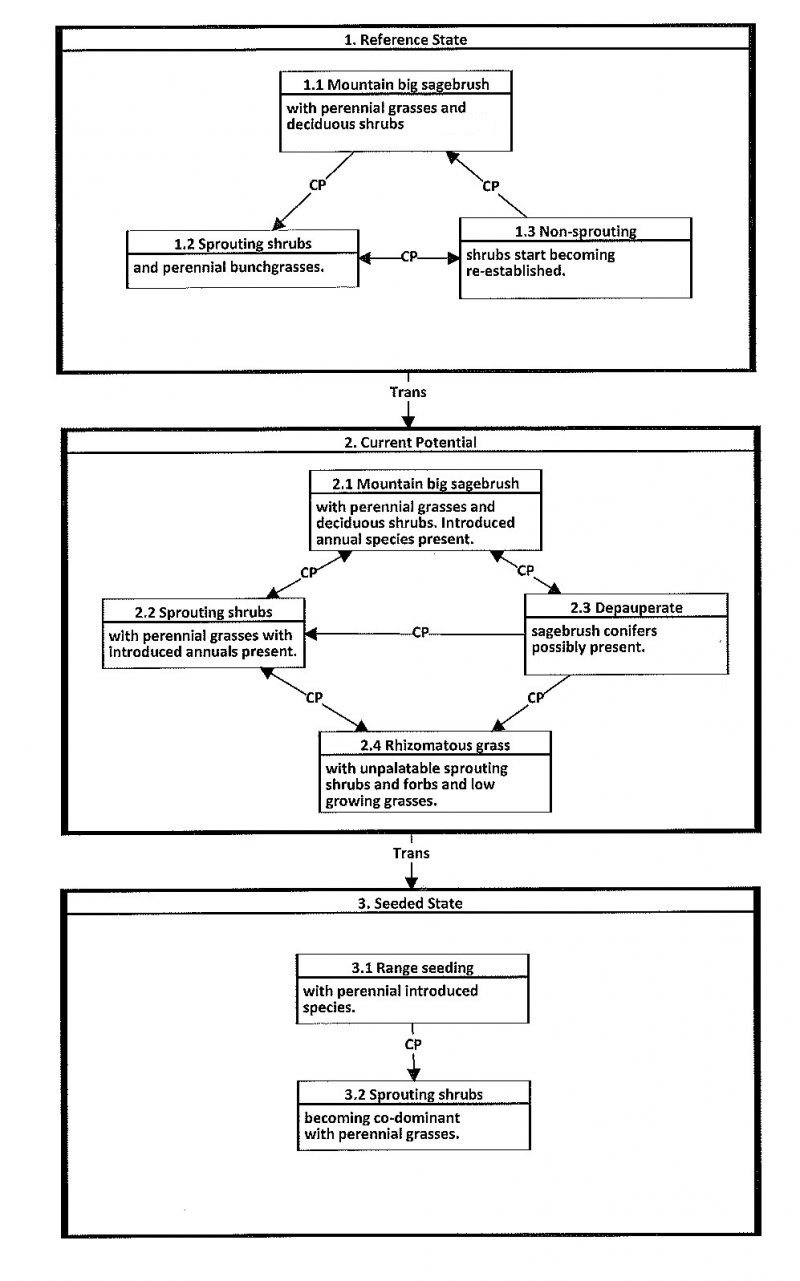
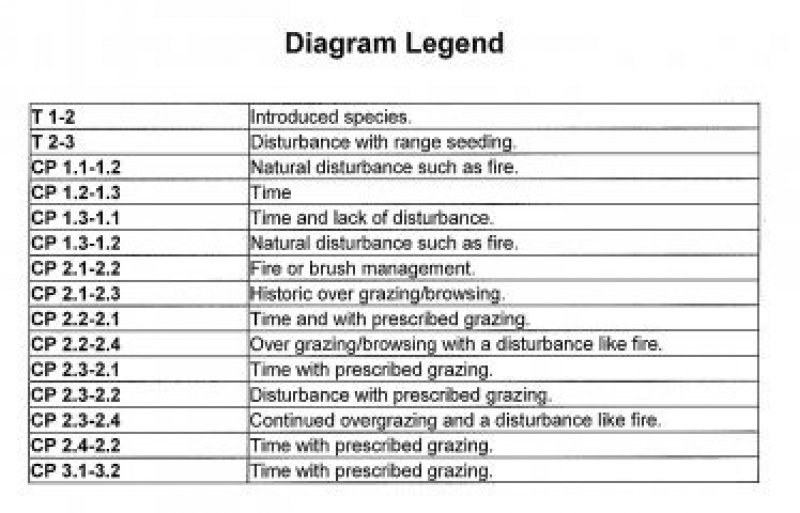
Below is a State and Transition Model diagram to illustrate the “phases” (common plant communities), and “states” (aggregations of those plant communities) that can occur on the site. Differences between phases and states depend primarily upon observations of a range of disturbance histories in areas where this ESD is represented. These situations include grazing gradients to water sources, fence-line contrasts, patches with differing dates of fire, herbicide treatment, tillage, etc. Reference State 1 illustrates the common plant communities that probably existed just prior to European settlement.
The major successional pathways within states, (“community pathways”) are indicated by arrows between phases. “Transitions” are indicated by arrows between states. The drivers of these changes are indicated in codes decipherable by referring to the legend at the bottom of the page and by reading the detailed narratives that follow the diagram. The transition between Reference State 1 and State 2 is considered irreversible because of the naturalization of exotic species of both flora and fauna, possible extinction of native species, and climate change. There may have also been accelerated soil erosion.
Plant Community Narratives:
The plant communities shown in this State and Transition Model may not represent every possibility, but are probably the most prevalent and recurring plant communities. As more monitoring data are collected, some phases or states may be revised, removed, and/or new ones may be added. None of these plant communities should necessarily be thought of as “Desired Plant Communities.” According to the USDA NRCS National Range & Pasture Handbook (USDA-NRCS 2003), Desired Plant Communities (DPC’s) will be determined by the decision-makers and will meet minimum quality criteria established by the NRCS. The main purpose for including descriptions of a plant community is to capture the current knowledge at the time of this revision.
State 1: Reference State:
The Reference State is a description of this ecological site just prior to Euro-American settlement but long after the arrival of Native Americans. The description of the Reference State was determined by NRCS Soil Survey Type Site Location information and familiarity with rangeland relict areas where they exist. The least modified plant community (1.1) within the Reference State would have been a sagebrush-dominated stand with mountain big sagebrush (Artemisia tridentata spp. vaseyana), mountain snowberry (Symphoricarpos oreophilus) and associated bunch grasses such as Salina wildrye (Leymus salinus), bluebunch wheatgrass (Pseudoroegeneria spicata), Nevada bluegrass (Poa secunda) and slender wheatgrass (Elymus trachycaulus). Forbs such as Arrowleaf balsamroot (Balsamorhiza sagittata), sticky purple geranium (Geranium viscosissimum) and fleabane (Erigeron sp.) would be present. Fire is believed to be the dominant disturbance force in natural big sagebrush communities. The reference plant community (1.1) would have been relatively stable with occasional use by wildlife. Following a natural fire (1.1a) and depending on the severity, would have killed most if not all of the sagebrush favoring the sprouting shrubs and bunchgrasses (1.2). Over time and without any further disturbances (1.2a) sagebrush and other non-sprouting shrubs would slowly come back into the site (1.3), however the sprouting shrubs and bunch grasses would still dominate the site. If there were another fire to occur on the site (1.3a) the site would return to community phase 1.2. If community phase 1.3 continued to experience no disturbances over a longer period of time (1.3b) it would eventually show a co-dominace between mountain big sagebrush and the other shrubs on the site. A more complete list of species by lifeform for the Reference State is available in the accompanying tables in the “Plant Community Composition by Weight and Percentage” section of this document.
Community Phase 1.1 Mountain big sagebrush with perennial grasses and deciduous shrubs.
The least modified plant community within the Reference State would have been a mountain big sagebrush-dominated with associated deciduous shrubs such as mountain snowberry, antelope bitterbrush, serviceberry and associated perennial grasses such as Salina wildrye and bluebunch wheatgrass. Arrowleaf balsamroot, sticky purple geramium and erigeron sp. would have been the commonly associated forbs.
Community Pathway 1.1a
A naturally occurring fire would have killed all the non-sprouting shrubs like mountain big sagebrush. As the site recovered, it would be converted to the sprouting shrubs with perennial bunchgrasses community.
Community Phase 1.2 Sprouting shrubs with perennial bunch grasses.
Fire is a naturally occurring disturbance on this site and would have kept shrubs like mountain big sagebrush and antelope bitterbrush less dominant. Sprouting shrubs like mountain snowberry and serviceberry and perennial grasses would have become the dominant aspect of this site.
Community Pathway 1.2a
Over time and without the occurrence of a natural disturbance, such as fire, non-sprouting shrubs like mountain big sagebrush, antelope bitterbrush and alderleaf mountain mahogany would become re-established on the site.
Community Phase 1.3 Non-sprouting shrubs start becoming re-established.
Non-sprouting shrubs start becoming re-established from seed over time. Sprouting shrubs and perennial grasses are still the dominant aspect of this site.
Community Pathway 1.3a
In the event that there is another natural disturbance, like a fire, the site would return to
the sprouting shrubs with perennial bunch grasses community.
Community Pathway 1.3b
Over time and with the absence of a natural disturbance, like fire, the non-sprouting
shrubs will continue becoming more abundant to a point where they are co-dominant
with the sprouting shrubs.
T1a: Transition from State 1 to State 2 (Reference State to Current Potential/ Introduced Non-natives State)
The simultaneous introduction of exotic species, both plants and animals, and possible extinctions of native flora and fauna, along with climate change, will cause State 1 to transition to State 2. A return pathway back to State 1 would be impracticable because of these issues.
State 2: Current Potential/Introduced Non-Natives State.
State 2 is identical to State 1 in form and function, with the exception of the presence of non-native plants and animals, possible extinctions of native species, and a different climate. State 2 is a description of the ecological site shortly following Euro-American settlement, which can be regarded as the current potential. The least modified plant community (2.1) within State 2 is a sagebrush (Artemisia tridentate spp. vaseyana) dominated state with mountain snowberry (Symphoricarpos oreophilus) and associated bunch grasses such as Salina wildrye (Leymus salinus), bluebunch wheatgrass (Pseudoroegeneria spicata), Nevada bluegrass (Poa secunda) and slender wheatgrass (Elymus trachycaulus). Forbs such as Arrowleaf balsamroot (Balsamorhiza sagittata), sticky purple geranium (Geranium viscosissimum) and fleabane (Erigeron sp.) would be present. A common non-native species in this state is cheatgrass. Fire is believed to be the dominant disturbance force in natural big sagebrush communities. Following brush management or fire (2.1a) and depending on the severity, would have killed most if not all of the sagebrush, and other non-sprouting shrubs, favoring the sprouting shrubs and bunchgrasses (2.2). This plant community is relatively stable under mixed use by wildlife and livestock. However, heavy utilization by bison, elk, horses, and domestic cattle on these sites during the growing season (2.1b) would deplete the grasses and deciduous shrubs creating site that is dominated by mountain big sagebrush (2.3). In community 2.2, when management, such as prescribed grazing, can be combined with time (2.2a) to allow the site to recover returning to community 2.1. However if the community continues to be over utilized by both wildlife and domestic livestock, and possibly in combination with a natural or man caused disturbance (2.2b) this community (2.2) can be degraded to community 2.4 which is dominated by rhizomatous grasses with unpalatable sprouting shrubs and forbs. In community 2.3 when management, such as prescribed grazing coupled with time, (2.3a) the sprouting shrubs and perennial grasses can have an opportunity to recover and recolonize the site and return to community 2.1. In community 2.3, when it experiences a disturbance such as brush management or fire, coupled with management like prescribed grazing (2.3b) it can drive the site to a more stable and diverse community 2.2. However, when community 2.3 continues to be over utilized and this is coupled with a disturbance such as brush management or fire (2.3c) it can drive the site to an undesirable community 2.4.
Community Phase 2.1: Mountain big sagebrush with perennial grasses and deciduous shrubs. Introduced annual species present.
The least modified community within the mountain big sagebrush/deciduous shrub/introduced state. This is a mountain big sagebrush dominated community with an abundance of deciduous shrubs such as mountain snowberry, antelope bitterbrush and serviceberry. Community is also characterized by an abundance of native perennial grasses such as, Salina wildrye, bluebunch wheatgrass, slender wheatgrass and Nevada bluegrass. Associated forbs on this site may consist of arrowleaf balsamroot, sticky purple geranium and erigeron sp. Introduced species likely to occur on this site are cheatgrass, annual forbs, milkweed and stickseed.
Community Pathway 2.1a
This pathway is characterized by the implementation of brush management, prescribed or natural fire. This will reduce the abundance of non-sprouting shrubs giving the competitive advantage to sprouting shrubs and native perennial grasses (2.2).
Community Pathway 2.1b
Heavy continuous grazing and browsing by wildlife and domestic animals would deplete resources of the deciduous shrubs and native perennial grasses (2.3).
Community Phase 2.2: Sprouting shrubs with perennial grasses with introduced annuals present.
This community represents what the site would look like following brush management or a natural or prescribed fire. Depending on the severity of the fire/management practice, some or all of the non-sprouting shrubs would be killed. This would open up resources for the sprouting shrubs and native perennial grasses subsequently they would be the dominant aspect of the site.
Community Pathway 2.2a
This pathway represents that over time and under normal climatic conditions, along with prescribed grazing, this community would return to the previous community (2.1).
Community Pathway 2.2b
This pathway represents when the community experiences heavy continuous grazing and browsing by wildlife and domestic animals. Natural disturbances such as fire could also occur simultaneously in this pathway (2.4).
Community Phase 2.3: Depauperate sagebrush with conifers possibly present.
This community represents what the site would look like following a long period of over grazing and browsing. The more palatable species would be heavily utilized giving a competitive advantage to species such as mountain big sagebrush. Over time sagebrush would be the dominant aspect of the site with a low diversity of the other native species that normally occur on the site.
Community Pathway 2.3a
This pathway represents that over time and under normal climatic conditions, along with prescribe grazing, this community would return to the previous community (2.1).
Community Pathway 2.3b
This pathway represents that over time and under normal climatic conditions, along with prescribe grazing along with a natural or prescribed fire or brush management mountain big sagebrush/conifers would be killed. This would stimulate the sprouting shrubs and perennial native grasses moving the site to community 2.2.
Community Pathway 2.3c
This pathway represents the occurrence when the site continues to be overgrazed and there is a disturbance like a fire. Non-sprouting shrubs and conifers, if present, would be killed. Deciduous shrubs and native perennial grasses are already at low diversity and stressed, giving the competitive advantage to rhizomatous grasses and unpalatable sprouting shrubs like rabbitbrush (2.4).
Community Phase 2.4: Rhizomatous grasses with unpalatable sprouting shrubs and forbs with low growing grasses.
This community represents the site when there has been continued overgrazing/browsing for an extended period of time, followed by a disturbance such as a brush management treatment or natural/prescribed fire. Species diversity was already low (2.3). The overutilization of the desirable native vegetation coupled with the fire has reduced the site to unpalatable sprouting shrubs and forbs along with low growing grasses.
Community Pathway 2.4a
This pathway represents that over time, along with prescribed grazing that the sprouting shrubs and native perennial grasses would eventually re-establish and return the site back to community 2.2.
T2a: Transition from State 2 to State 3 (Current Potential to Seeded State)
When land managers or landowners have made the decision that the herbaceous understory species are so depleted and/or undesirable, and the biological, hydrological and soil resources are at risk, introduced and native perennial grasses are utilized in a range seeding. This often occurs in combination with a natural/prescribed fire or other brush management treatment.
State 4: Seeded State:
This State occurs where historic excessive livestock grazing reduced canopy cover, and in an attempt to prevent any additional excessive erosion it was intentionally seeded with species such as smooth brome and/or crested wheatgrass. Do to the decreased canopy cover and increased erosion, and rangeland seeding is utilized, either rangeland drilled or aerial application with predominately introduced species.
Community Phase 3.1: Range seeding with perennial introduced species.
This community represents a time shortly following a brush management treatment/fire in addition to the range seeding. Non-sprouting shrubs have been greatly reduced and sprouting shrubs have not had adequate time to become re-established. Introduced and native grass species with a few sprouting shrubs dominate the site.
Community Pathway 3.1a
Over an extended period of time and in combination with prescribed grazing, the native desirable sprouting shrubs begin to become well established.
Community Phase 3.2: Sprouting shrubs becoming co-dominant with perennial grasses.
This community phase represents the site over a 5-10 year period of time under normal climatic conditions. The desirable sprouting shrubs have had adequate time to re-establish and become co-dominant with the perennial grasses. Non-sprouting shrubs have also started to re-establish on the site as well. It is imperative that prescribed grazing must be implemented in order for this community to be persist.
The general view of this site is Salina wildrye and mountain big sagebrush. The natural plant community is composed of approximately 60 percent perennial grasses, 10 percent forbs, and 30 percent shrubs by air-dry weight. No trees are found in the potential natural plant community, other that a few scattered Douglas-fir and Gambel oak.
Figure 2. Annual production by plant type (representative values) or group (midpoint values)
Table 5. Annual production by plant type
Plant type
Low (lb/acre)
Representative value (lb/acre)
High (lb/acre)
Grass/Grasslike
570
870
1170
Shrub/Vine
285
435
585
Forb
95
145
195
Total
950
1450
1950
Table 6. Ground cover
Tree foliar cover
0%
Shrub/vine/liana foliar cover
19-21%
Grass/grasslike foliar cover
39-41%
Forb foliar cover
4-6%
Non-vascular plants
0%
Biological crusts
0%
Litter
0%
Surface fragments >0.25" and <=3"
0%
Surface fragments >3"
0%
Bedrock
0%
Water
0%
Bare ground
0%
Table 7. Canopy structure (% cover)
Height Above Ground (ft)
Tree
Shrub/Vine
Grass/ Grasslike
Forb
<0.5
–
–
–
–
>0.5 <= 1
–
–
–
4-6%
>1 <= 2
–
19-21%
39-41%
–
>2 <= 4.5
–
–
–
–
>4.5 <= 13
–
–
–
–
>13 <= 40
–
–
–
–
>40 <= 80
–
–
–
–
>80 <= 120
–
–
–
–
>120
–
–
–
–
Additional community tables
Table 8. Community 1.1 plant community composition
Salina wildrye provides a moderate amount of fair quality forage during the growing season but is unpalatable when mature and dried. (Valentine 1961; from Welsh et al: A Utah Flora 1987 pg. 726).
This site produces food and cover for wildlife. Wildlife species that use this site include sage grouse, rabbit, coyote, mule deer, and elk.
Hydrological functions
The soil series in this site are in hydrologic group B and C. The runoff curve numbers are 61 through 86 depending on the condition of the watershed.
Recreational uses
This site offers color and aesthetic appeal during the growing season. Recreation values include hiking and hunting.
Wood products
None
Supporting information
Inventory data references
Type Location: See Carbon Soil Survey for location.
Contributors
George Cook, David Somerville
Approval
Kirt Walstad, 3/01/2024
Rangeland health reference sheet
Interpreting Indicators of Rangeland Health is a qualitative assessment protocol used to
determine ecosystem condition based on benchmark characteristics described in the Reference Sheet. A suite of 17 (or
more) indicators are typically considered in an assessment. The ecological site(s) representative of an assessment
location must be known prior to applying the protocol and must be verified based on soils and climate. Current plant
community cannot be used to identify the ecological site.
Author(s)/participant(s)
Jack Alexander, Range Specialist, Synergy Resource Solutions, Inc.
Julia Kluck, Soil Scientist, Synergy Resource Solutions, Inc. , Shane Green, NRCS
Contact for lead author
shane.green@ut.usda.gov
Date
02/07/2014
Approved by
Kirt Walstad
Approval date
Composition (Indicators 10 and 12) based on
Annual Production
Indicators
Number and extent of rills:
Some rills present. Rill development may increase following large storm events, but should begin to heal during the following growing season. Frost heaving will accelerate recovery. Rill development may increase when run inflow enters site from other sites that produce large amounts of runoff (i.e. steeper sites, slickrock, rock outcrop).
Presence of water flow patterns:
Water flow patterns will be short (2-5’) and meandering; interrupted by plants and exposed rocks. Some evidence of erosion or deposition associated with flow patterns. Where slopes exceed 5%, water flow patterns may be longer (5–10’).
Number and height of erosional pedestals or terracettes:
Plants may have small pedestals (1-3”) where they are adjacent to water flow patterns, but without exposed roots. Terracettes should be few and stable. Terracettes should be small (1-3”) and show little sign of active erosion. Some plants may appear to have a pedestal but rather than be formed by erosion, they are the result of litter and soil accumulating at plant bases, forming the appearance of a pedestal.
Bare ground from Ecological Site Description or other studies (rock, litter, lichen, moss, plant canopy are
not bare ground):
15-25% bare ground (soil with no protection from raindrop impact). Very few if any bare spaces of greater than 1 square foot. In general, bare ground increases as production decreases. As species composition of shrubs relative to grasses increases, bare ground is likely to increase. Poorly developed biological soil crust that is susceptible to erosion from raindrop impact should be recorded as bare ground.
Number of gullies and erosion associated with gullies:
No gullies present.
Extent of wind scoured, blowouts and/or depositional areas:
Very minor evidence of active wind-generated soil movement. Wind scoured (blowouts) and depositional areas are rarely present. If present they have muted features and are mostly stabilized with vegetation and/or biological crust.
Amount of litter movement (describe size and distance expected to travel):
Most litter resides in place with some redistribution caused by water and wind movement. Very minor litter removal may occur in water flow paths with deposition occurring at points of obstruction. Where litter movement does occur, litter accumulates at plant bases. Some leaves, stems, and small twigs may accumulate in soil depressions adjacent to plants. Woody stems are not likely to move.
Soil surface (top few mm) resistance to erosion (stability values are averages - most sites will show a range
of values):
This site should have an erosion rating of 5 to 6 under plant canopies and a rating of 4 to 5 in the interspaces with an average rating of 5 using the soil stability kit test.
Soil surface structure and SOM content (include type of structure and A-horizon color and thickness):
A--0 to 9 inches; dark grayish brown (10YR 4/2) sandy loam, very dark brown (10YR 2/2) moist; weak medium subangular blocks parting to moderate fine granular structure; soft, very friable; slightly acid; clear wavy boundary. (4 to 15 inches thick)
Effect of community phase composition (relative proportion of different functional groups) and spatial
distribution on infiltration and runoff:
Bunchgrasses and shrubs are equally important for increasing infiltration and reducing runoff. Plant litter and canopy cover from all functional groups intercept rainfall and prevent splash erosion. Bunchgrasses contribute organic matter directly to soil through root decay, and organic matter helps stabilize soil aggregates and maintain soil porosity. Shrubs hold snow and slow wind evaporation. Bunchgrass bases intercept litter and soil in water flow paths, reducing runoff. Biological soil crusts (where present) are resistant to raindrop impact and splash erosion. Spatial distribution of vascular plants and well-developed biological soil crusts (where present) provides detention storage and surface roughness that slows runoff allowing time for infiltration. Interspaces between plants and any well-developed biological soil crusts (where present) may serve as water flow patterns during episodic runoff events, with natural erosion expected in severe storms.
Presence and thickness of compaction layer (usually none; describe soil profile features which may be
mistaken for compaction on this site):
A compaction layer is not expected.
Functional/Structural Groups (list in order of descending dominance by above-ground annual-production or live foliar
cover using symbols: >>, >, = to indicate much greater than, greater than, and equal to):
Other: Other perennial grasses > forbs = other shrubs
Additional:
Amount of plant mortality and decadence (include which functional groups are expected to show mortality or
decadence):
During years with average to above average precipitation, there should be very little recent mortality or decadence apparent in either the shrubs or grasses. Some mortality of bunchgrass and other shrubs may occur during very severe (long-term) droughts. There may be partial mortality of individual bunchgrasses and shrubs during less severe drought and toward the end of the fire cycle. Long-lived species dominate the site. Open spaces from disturbance are quickly filled by new plants through seedlings and asexual reproduction (tillering).
Average percent litter cover (%) and depth ( in):
Litter cover includes litter under plants. Most litter will be fine (herbaceous) litter. Litter will be concentrated under plant canopies and sparser between plant canopies, with an average cover of AA-BB% and an average depth of XX-YY inches. Litter cover may increase following years with favorable growing conditions. Excess litter may accumulate in absence of disturbance. Vegetative production may be reduced if litter cover exceeds 40%.
Expected annual annual-production (this is TOTAL above-ground annual-production, not just forage annual-production):
1400-1500/acre.
Even the most stable communities exhibit a range of production values. Production will vary between communities and across the MRLA. Refer to the community descriptions in the ESD. Production will differ across the MLRA due to the naturally occurring variability in weather, soils, and aspect. The biological processes on this site are complex; therefore, representative values are presented in a land management context.
Potential invasive (including noxious) species (native and non-native). List species which BOTH characterize
degraded states and have the potential to become a dominant or co-dominant species on the ecological site if
their future establishment and growth is not actively controlled by management interventions. Species that become
dominant for only one to several years (e.g., short-term response to drought or wildfire) are not invasive
plants. Note that unlike other indicators, we are describing what is NOT expected in the reference state for the
ecological site:
Cheatgrass, kochia, Russian thistle, Utah juniper
Perennial plant reproductive capability:
All perennial plants should have the ability to reproduce sexually or asexually, except in drought years. Density of plants indicates that plants reproduce at level sufficient to fill available resource. Within capability of site there are no restrictions on seed or vegetative reproductive capacity.
The Ecosystem Dynamics Interpretive Tool is an information system framework developed by the USDA-ARS Jornada Experimental Range, USDA Natural Resources Conservation Service, and New Mexico State University.
Click on box and path labels to scroll to the respective text.