
Natural Resources
Conservation Service
Ecological site EX049X01X202
Loamy Foothill Palmer Divide
Last updated: 5/02/2025
Accessed: 03/24/2026
General information
Provisional. A provisional ecological site description has undergone quality control and quality assurance review. It contains a working state and transition model and enough information to identify the ecological site.
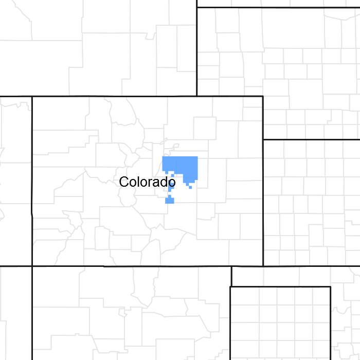
Figure 1. Mapped extent
Areas shown in blue indicate the maximum mapped extent of this ecological site. Other ecological sites likely occur within the highlighted areas. It is also possible for this ecological site to occur outside of highlighted areas if detailed soil survey has not been completed or recently updated.
MLRA notes
Major Land Resource Area (MLRA): 049X–Southern Rocky Mountain Foothills
Major Land Resource Area (MLRA) 49, Southern Rocky Mountain Foothills, is approximately 11,130 square miles running north to south, from south-central Wyoming (27 percent), the length of the Front Range of Colorado (58 percent), and into north-central New Mexico (15 percent).
Almost half of this area is located in the Southern Rocky Mountains and Wyoming Basin provinces of the Rocky Mountain system.
The remainder is in the Colorado Pediment, Raton, and High Plains Section of the Great Plains Province of the Interior Plains. The northern part consists of the Laramie Mountains. The central and southern parts are bounded on the east by the Great Plains and on the west by the Southern Rocky Mountains (USDA Ag. Handbook 296). Average elevation is from 5,000 to 8,000 feet. Annual precipitation is 10 to 35 inches.
LRU notes
The Palmer Divide Land Resource Unit (LRU) is a transition zone between the mountains and plains and describes the central Colorado foothills of the Front Range, including the Palmer Divide. It includes the cities of Highlands Ranch, Castle Rock, and Kiowa in Douglas and Elbert counties. The Black Forest-Palmer Divide area is central, while Cheyenne Mountain State Park at Colorado Springs is the southernmost extent in El Paso County. It is characterized by Gambel oak (Quercus gambelii) and ponderosa pine (Pinus ponderosa), with ponderosa pine increasing at higher elevations. The ponderosa pine transitions into grasslands on the drier eastern fringes as it transitions into the plains. This area was historically used for ranching, limited farming, logging, mining, and quarry activities. The area experienced an influx of people during the Colorado Gold Rush of 1859. Because of its proximity to Denver and Colorado Springs, many of the original ranches and small towns have been converted to subdivisions, small acreages, and suburbs. Some cities, such as Castle Rock, have zoned "open space" for recreation.
Classification relationships
NRCS:
Major Land Resource Area 49, Southern Rocky Mountain Foothills (United States Department of Agriculture, Natural Resources Conservation Service, 2006).
Ecological site concept
The Loamy Foothills site is a run-off site that receives no extra water beyond normal precipitation. It is not influenced by rock fragments in the surface horizon and has loamy surface textures. Positioned on fans, fan remnants, hills, hillslopes, and valley sides, the site ranges from 5,300 feet to 7,400 feet in elevation, and has slopes that are nearly level to 15 percent. The soils are generally moderately deep to very deep, well drained, and have moderately slow to moderately permeability. The surface layers generally have loam, silt loam, and very fine sandy loam textures.
Associated sites
| EX049X01X214 |
Gravelly Foothill Palmer Divide This site is intermixed with and often positioned higher on the landscape than the loamy site. |
|---|
Similar sites
| EX049X01X208 |
Clayey Foothill Palmer Divide This site has a fine family particle size and has surface textures of clay loam, clay, silty clay, or silty clay loam |
|---|---|
| EX049X01X210 |
Sandy Foothill Palmer Divide This site has a coarse-loamy or sandy family particle size and has surface textures of fine sandy loam, loamy sand, or sand. |
Table 1. Dominant plant species
| Tree |
Not specified |
|---|---|
| Shrub |
(1) Krascheninnikovia lanata |
| Herbaceous |
(1) Pascopyrum smithii |
Legacy ID
R049XC202CO
Physiographic features
The Loamy Foothill ecological site exists on fans, fan remnants, hills, hillslopes, and valley sides. Slopes are nearly level to 20 percent.
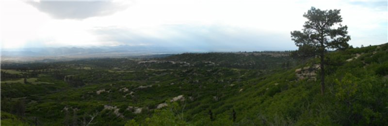
Figure 2. MLRA 49X_01 Front Range Foothills of Central Colorado
Table 2. Representative physiographic features
| Landforms |
(1)
Fan
(2) Hill (3) Valley side (4) Hillslope |
|---|---|
| Flooding duration | Extremely brief (0.1 to 4 hours) |
| Flooding frequency | None to rare |
| Ponding frequency | None |
| Elevation | 5,300 – 7,400 ft |
| Slope | 1 – 15% |
| Ponding depth |
Not specified |
| Water table depth | 60 in |
| Aspect | W, NW, N, NE, E, SE, S, SW |
Table 3. Representative physiographic features (actual ranges)
| Flooding duration | Not specified |
|---|---|
| Flooding frequency | Not specified |
| Ponding frequency | Not specified |
| Elevation | 5,300 – 7,400 ft |
| Slope | 20% |
| Ponding depth | Not specified |
| Water table depth | 60 in |
Climatic features
The average annual precipitation is 14 to 19 inches per year but can vary from 11 to 20 inches depending upon the year and location within the LRU. Approximately 60 to 75 percent of the annual precipitation occurs during the growing season from late April to late September. The Rocky Mountains to the west intercept much of the precipitation from Pacific storms during the winter. Snowfall can vary from 39 inches to 75 inches, depending upon elevation and location. Snowfall averages 63 inches annually across the LRU. Wind speeds average 10 miles per hour annually. Daytime winds are generally stronger than nighttime, and occasional strong storms may bring brief periods of high winds with gusts to more than 60 miles per hour.
The average length of the freeze-free period is 142 days but varies from 111 to 172 days in 5 out of 10 years. The average date of first freeze (28 degrees or below) in the fall is September 22, and the average last freeze in the spring is May 17. July is the hottest month and January is the coldest. Summer temperatures are moderate, with average highs in the low 80s and occasionally reaching the mid-90s.
Summer nights are comfortably cool, with lows averaging in the 50s. Higher elevations can receive a dusting of snow in early September. Severe cold is normally of short duration. Summer humidity is low and evaporation is high.
Cool-season plants generally begin growth from April 1 to April 15. Native warm-season plants typically begin growth about May 1 to May 15. Cool-season plants generally continue to grow through the summer and fall, in comparison to the warmer and drier eastern plains where cool-season plants exhibit summer dormancy.
Table 4. Representative climatic features
| Frost-free period (characteristic range) | 104-119 days |
|---|---|
| Freeze-free period (characteristic range) | 133-139 days |
| Precipitation total (characteristic range) | 14-19 in |
| Frost-free period (actual range) | 101-125 days |
| Freeze-free period (actual range) | 131-143 days |
| Precipitation total (actual range) | 11-20 in |
| Frost-free period (average) | 112 days |
| Freeze-free period (average) | 136 days |
| Precipitation total (average) | 17 in |
Figure 3. Monthly precipitation range
Figure 4. Monthly minimum temperature range
Figure 5. Monthly maximum temperature range
Figure 6. Monthly average minimum and maximum temperature
Figure 7. Annual precipitation pattern
Figure 8. Annual average temperature pattern
Climate stations used
-
(1) COLORADO SPRINGS MUNI AP [USW00093037], Colorado Springs, CO
-
(2) PARKER 6 E [USC00056326], Parker, CO
-
(3) CASTLE ROCK [USC00051401], Castle Rock, CO
-
(4) ELIZABETH 2NW [USC00052631], Elizabeth, CO
-
(5) RUSH 1N [USC00057287], Rush, CO
Influencing water features
This site is not associated with any water features.
Wetland description
This site is not associated with wetland characteristics.
Soil features
The soils at this site are moderately deep to very deep. They are well-drained and have moderately slow or moderately permeable. These soils are formed from loamy alluvium and residuum that has been modified by local wind deposits from sandstone, siltstone and shale. This ecological site occurs on fans, fan remnants, and valley sides. The available water capacity is typically high for the very deep soils and low to moderate for the moderately deep soils. The soil surface layer is three to 16 inches thick with loam, silt loam, and very fine sandy loam textures. The pH of these soils ranges from neutral to moderately alkaline. The soil moisture regime is aridic ustic or ustic with some ustic aridic in the drier areas in the eastern part of the LRU. The soil temperature regime is mesic.
The Reference state should show slight to no evidence of rills, wind-scoured areas or pedestaled plants. Water flow patterns are broken, irregular in appearance or discontinuous with numerous debris dams or vegetative barriers. The soil surface is stable and intact. Subsurface soil layers are non-restrictive to water movement and root penetration. Major soil series correlated to this ecological site include Buick, Cushman, Fondis, Rednun, and Sampson.
Other soil series that are correlated to this site, but may be re-correlated in the future include Ascalon, Baca, Colby, Connerton, Lavate, Nunn, Renohill, Satanta, Weld, and Wiley.
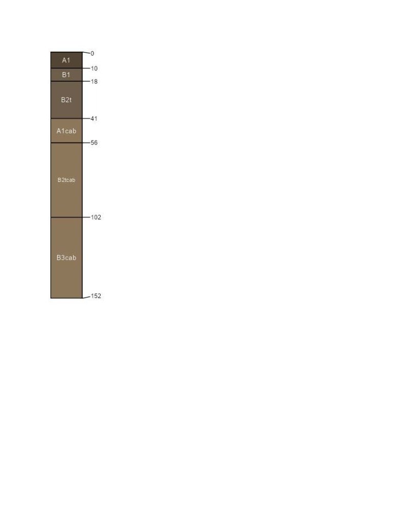
Figure 9. Buick series profile.
Table 5. Representative soil features
| Parent material |
(1)
Alluvium
–
shale
(2) Residuum – siltstone (3) Eolian deposits – sandstone |
|---|---|
| Surface texture |
(1) Loam (2) Silt loam (3) Very fine sandy loam |
| Family particle size |
(1) Loamy |
| Drainage class | Well drained |
| Permeability class | Slow to moderate |
| Soil depth | 20 – 80 in |
| Surface fragment cover <=3" | 10% |
| Surface fragment cover >3" | Not specified |
| Available water capacity (0-40in) |
3 – 9 in |
| Calcium carbonate equivalent (0-40in) |
15% |
| Electrical conductivity (0-40in) |
2 mmhos/cm |
| Sodium adsorption ratio (0-40in) |
4 |
| Soil reaction (1:1 water) (0-40in) |
6.6 – 8.4 |
| Subsurface fragment volume <=3" (Depth not specified) |
15% |
| Subsurface fragment volume >3" (Depth not specified) |
Not specified |
Table 6. Representative soil features (actual values)
| Drainage class | Not specified |
|---|---|
| Permeability class | Not specified |
| Soil depth | 20 – 80 in |
| Surface fragment cover <=3" | 10% |
| Surface fragment cover >3" | Not specified |
| Available water capacity (0-40in) |
3 – 9 in |
| Calcium carbonate equivalent (0-40in) |
15% |
| Electrical conductivity (0-40in) |
2 mmhos/cm |
| Sodium adsorption ratio (0-40in) |
4 |
| Soil reaction (1:1 water) (0-40in) |
6.6 – 8.4 |
| Subsurface fragment volume <=3" (Depth not specified) |
15% |
| Subsurface fragment volume >3" (Depth not specified) |
Not specified |
Ecological dynamics
The Loamy Foothills ecological site consists of the Reference, Altered, and Eroded states. Transitions between states and their respective communities are primarily driven by natural disturbance regimes, the most significant being periodic drought, grazing that results in chronic defoliation (both natural and agricultural), and fire. The timing and magnitude of these disturbances affect the various stages of the vegetative communities as described in the state and transition model.
The historical fire frequency of the Palmer Divide LRU ranges from six to 10 years (Guyette, et al). The impact of fire over the past 50 years has been relatively insignificant due to wildfire suppression and the lack of acceptance of prescribed fire as a management tool. Prolonged drought, coupled with fire suppression, has increased the frequency and intensity of periodic wildfires in the area.
Most of this ecological site has been fragmented due to tillage, and urban development.
A state and transition model (STM) diagram for this ecological site is depicted in this section. Thorough descriptions of each state, transition, plant community, and pathway are found after the state and transition model. This STM is based on available experimental research, field observations, professional consensus, and interpretations. While based on the best available information, the STM may change over time as knowledge of ecological processes increases.
State and transition model
More interactive model formats are also available.
View Interactive Models
Click on state and transition labels to scroll to the respective text
Ecosystem states
| R2A | - | Prescribed Grazing. Prescribed Burning. Range Planting. |
|---|---|---|
| R3A | - | Prescribed Grazing. Prescribed Burning. Range Planting. Invasive Plant Species Control. |
State 1 submodel, plant communities
| 1.2A | - | Prescribed Grazing. Prescribed Burning. |
|---|---|---|
| 1.3A | - | Prescribed Grazing. Prescribed Burning. |
State 2 submodel, plant communities
State 3 submodel, plant communities
State 1
Reference
The Reference state of the Loamy Foothill Palmer Divide ecological site is a dynamic state that contains three vegetative communities. These communities fluctuate within the parameters that define the state. Precipitation patterns and management strategies regarding herbivory and the presence or absence of fire are the primary drivers that determine the distribution of these communities throughout this state (Anderson, et al, 1982).
Characteristics and indicators. This state has not been sodbusted or overly eroded and has only slight to moderate vegetative deviation from the historical mixed-grass prairie community.
Resilience management. The Reference state can be maintained by managing herbivory with appropriate stocking rates, and timing and duration of grazing periods. Maintaining a natural fire regime with appropriately timed prescribed burning also contributes to the overall resilience of this state.
Dominant plant species
-
winterfat (Krascheninnikovia lanata), shrub
-
fourwing saltbush (Atriplex canescens), shrub
-
western wheatgrass (Pascopyrum smithii), grass
-
blue grama (Bouteloua gracilis), grass
-
scarlet globemallow (Sphaeralcea coccinea), other herbaceous
-
American vetch (Vicia americana), other herbaceous
Community 1.1
Western Wheatgrass, Blue Grama, Winterfat, and Fourwing Saltbush
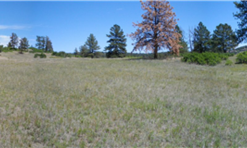
Figure 10. Plant Community 1.1
This plant community evolved with grazing by large herbivores and is well suited for grazing by domestic livestock as well as many wildlife species. It can be found on areas that are properly managed with prescribed grazing that allows for adequate recovery periods following each grazing event. The potential vegetation is about 70 to 85 percent grasses and grass-like plants, 10 to 15 percent forbs and five to 15 percent woody plants. The major grasses include western wheatgrass (Pascopyrum smithii) and blue grama (Bouteloua gracilis). Subdominant grasses include green needlegrass (Nassella viridula) and big bluestem (Andropogon gerardii). Minor grasses and grasslikes include mountain muhly (Muhlenbergia montana), little bluestem (Schizachryium scoparium), sideoats grama (Bouteloua curtipendula), needle and thread (Hesperostipa comata), prairie Junegrass (Koeleria macrantha), buffalograss (Bouteloua dactyloides), and long-stolon sedge (Carex inops) (locally known as sun sedge) . Major forbs include American vetch (Vicia americana, upright prairie coneflower (Ratibida columnifera), scarlet globemallow (Sphaeralcea coccinea), purple prairieclover (Dalea purpurea), and dotted blazing star (Liatris punctata. Shrubs include winterfat (Krascheninnikovia lanata), and fourwing saltbush (Atriplex canescens). This plant community is diverse, stable, and productive. Litter is uniformly distributed with very little movement off site and natural plant mortality is very low. It is well suited to carbon sequestration, water infiltration, wildlife use by many species, livestock use, and is aesthetically pleasing. Community dynamics, nutrient cycle, water cycle and energy flow are functioning properly. This community is resistant to many disturbances with the exceptions of excessive herbivory, tillage, and development into urban or other uses. Total annual production is 1,700 pounds per acre (air-dry) during an average precipitation year and ranges from 1,100 to 2,200.
Resilience management. This community can be maintained by managing herbivory with appropriate stocking rates, and timing and duration of grazing periods. Maintaining a natural fire regime with appropriately timed prescribed burning also contributes to resilience.
Dominant plant species
-
fourwing saltbush (Atriplex canescens), shrub
-
winterfat (Krascheninnikovia lanata), shrub
-
western wheatgrass (Pascopyrum smithii), grass
-
blue grama (Bouteloua gracilis), grass
-
American vetch (Vicia americana), other herbaceous
-
scarlet globemallow (Sphaeralcea coccinea), other herbaceous
Figure 11. Annual production by plant type (representative values) or group (midpoint values)
Table 7. Annual production by plant type
| Plant type | Low (lb/acre) |
Representative value (lb/acre) |
High (lb/acre) |
|---|---|---|---|
| Grass/Grasslike | 850 | 1315 | 1705 |
| Forb | 140 | 215 | 275 |
| Shrub/Vine | 110 | 170 | 220 |
| Total | 1100 | 1700 | 2200 |
Table 8. Ground cover
| Tree foliar cover | 0-1% |
|---|---|
| Shrub/vine/liana foliar cover | 3-10% |
| Grass/grasslike foliar cover | 50-80% |
| Forb foliar cover | 1-15% |
| Non-vascular plants | 0-1% |
| Biological crusts | 0-1% |
| Litter | 0-15% |
| Surface fragments >0.25" and <=3" | 0-1% |
| Surface fragments >3" | 0-1% |
| Bedrock | 0% |
| Water | 0% |
| Bare ground | 0-10% |
Table 9. Soil surface cover
| Tree basal cover | 0-1% |
|---|---|
| Shrub/vine/liana basal cover | 0-5% |
| Grass/grasslike basal cover | 7-15% |
| Forb basal cover | 0-5% |
| Non-vascular plants | 0-1% |
| Biological crusts | 0-1% |
| Litter | 0% |
| Surface fragments >0.25" and <=3" | 0-5% |
| Surface fragments >3" | 0-1% |
| Bedrock | 0% |
| Water | 0% |
| Bare ground | 50-90% |
Figure 12. Plant community growth curve (percent production by month). CO4925, Cool season dominant, warm season sub-dominant; MLRA 49C; upland loamy soils. Loamy Foothill in MLRA 49C, Reference Community; Western wheatgrass, blue grama, fourwing saltbush; warm/cool season, mixed, short, and midgrass.
| Jan | Feb | Mar | Apr | May | Jun | Jul | Aug | Sep | Oct | Nov | Dec |
|---|---|---|---|---|---|---|---|---|---|---|---|
| J | F | M | A | M | J | J | A | S | O | N | D |
| 2 | 5 | 15 | 20 | 25 | 20 | 10 | 3 |
Community 1.2
Decadent Western Wheatgrass, Blue Grama, Winterfat, and Fourwing Saltbush
This plant community occurs when grazing is removed for long periods in the absence of fire. Plant composition is similar to community 1.1; however, individual species production and frequency are lower. White sagebrush (Artemisia ludoviciana) and prairie sagebrush (Artemisia frigida) often increase. Introduced species such as spotted knapweed (Centaurea) cheatgrass (Bromus tectorum), and similar plants may also invade. Much of the nutrients are tied up in excessive litter. The semiarid environment and the absence of animal impact to break down litter slow nutrient recycling. Aboveground litter also limits sunlight from reaching plant crowns. Many plants die off. Thick litter and the absence of grazing and fire reduce seed germination and establishment. In advanced stages, plant mortality can increase and erosion may eventually occur if bare ground increases. Once this happens it will require increased input to bring back. Total annual production is 900 pounds per acre (air-dry) during an average precipitation year and ranges from 500 to 1,300 pounds per acre.
Resilience management. To sustain this community, occasional light disturbance from herbivory or prescribed fire is recommended.
Dominant plant species
-
fourwing saltbush (Atriplex canescens), shrub
-
winterfat (Krascheninnikovia lanata), shrub
-
western wheatgrass (Pascopyrum smithii), grass
-
blue grama (Bouteloua gracilis), grass
Community 1.3
At Risk Blue Grama Dominated
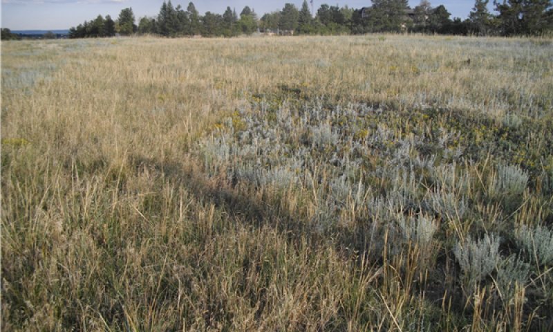
Figure 13. At Risk Blue Grama Dominated
Species such as western wheatgrass, big bluestem, green needlegrass, American vetch, fourwing saltbush, and winterfat have been reduced to remnant amounts. Blue grama has increased, dominates the plant community, and is beginning to take on a sod appearance. Sand dropseed (Sporobolus cryptandrus), purple threeawn ( Aristida purpurea), sixweeks fescue (Vulpia octoflora), plains pricklypear (Opuntia polyacantha), have also increased. This plant community is at risk of losing western wheatgrass, big bluestem, and green needlegrass. Total aboveground carbon has been reduced due to decreases in forage and litter production. Reduction of rhizomatous wheatgrass, nitrogen-fixing forbs, and the shrub component with an increase of warm-season short grasses has begun to alter the biotic integrity of this community. Water and nutrient cycles may be impaired. Total annual production is 1,000 pounds per acre (air-dry) during an average precipitation year and ranges from 600 to 1,400.
Resilience management. Resilience management for this community is to adjust the herbivory impacts through stocking rate, timing, and frequency of the grazing period prior to conversion to a sod-bound state.
Dominant plant species
-
prairie sagewort (Artemisia frigida), shrub
-
rubber rabbitbrush (Ericameria nauseosa), shrub
-
blue grama (Bouteloua gracilis), grass
-
western wheatgrass (Pascopyrum smithii), grass
-
hairy false goldenaster (Heterotheca villosa), other herbaceous
Pathway 1.1A
Community 1.1 to 1.2
Lack of disturbances such as herbivory, mowing, and and fire allows this plant community to degrade to the Decadent Western Wheatgrass, Blue Grama, Winterfat, and Fourwing Saltbush community.
Context dependence. The amount of growing season precipitation affects the rate and degree of this community shift.
Pathway 1.1B
Community 1.1 to 1.3
Excessive herbivory without adequate recovery periods between grazing events shifts this plant community to the At Risk Blue Grama Dominated community.
Context dependence. Drought accelerates this process.
Pathway 1.2A
Community 1.2 to 1.1
Prescribed grazing with adequate recovery periods between each grazing event and a proper stocking rate restores this plant community to the Western Wheatgrass, Blue Grama, Winterfat, and Fourwing Saltbush community. Prescribed burning accelerates this process.
Context dependence. Abundant growing season precipitation accelerates this process, while drought hampers recovery.
Conservation practices
| Prescribed Burning | |
|---|---|
| Prescribed Grazing |
Pathway 1.3A
Community 1.3 to 1.1
Prescribed grazing with adequate recovery periods after each grazing occurrence coupled with a proper stocking rate restores this plant community to the Western Wheatgrass, Blue Grama, Winterfat, and Fourwing Saltbush community. Appropriately timed prescribed burning assists this process.
Context dependence. Abundant growing season precipitation accelerate this process, while drought hampers recovery.
Conservation practices
| Prescribed Burning | |
|---|---|
| Prescribed Grazing |
State 2
Altered
The Altered state consists of one community.
Characteristics and indicators. The dominant plant community in this state has been significantly altered when compared to the dominant plant communities in the Reference state. Blue grama is the primary species, and the majority of the other native grasses and desirable forbs and shrubs are absent or greatly diminished. Erosion is not a major issue in this state.
Resilience management. The Altered state is extremely resilient, and moderate herbivory maintains the status quo.
Dominant plant species
-
plains pricklypear (Opuntia polyacantha), shrub
-
rubber rabbitbrush (Ericameria nauseosa), shrub
-
blue grama (Bouteloua gracilis), grass
-
prairie sagewort (Artemisia frigida), other herbaceous
-
hairy false goldenaster (Heterotheca villosa), other herbaceous
Community 2.1
Blue Grama
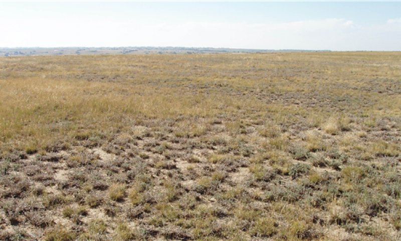
Figure 14. Blue Grama Community
Fourwing saltbush, winterfat, American vetch, big bluestem, and green needlegrass have been removed. Western wheatgrass may persist in depressions in trace amounts, greatly reduced in vigor, and not readily seen. Blue grama dominates the community with a tight "sod-bound" structure. Sand dropseed (Sporobolus cryptandrus), purple threeawn (Aristida purpurea), sixweeks fescue (Vulpia octoflora), plains pricklypear (Opuntia polyacantha), and other less palatable species have also increased. A significant amount of production and diversity have been lost when compared to the Western Wheatgrass, Blue Grama, Winterfat, and Fourwing Saltbush community. Loss of cool-season grasses, the shrub component, and nitrogen-fixing forbs have negatively impacted energy flow and nutrient cycling. Water infiltration is reduced significantly due to the massive shallow root system "root pan", which is characteristic of sod-bound blue grama and buffalograss (Bouteloua dactyloides). Soil loss may be obvious where flow paths are connected. During periods of extended drought, the mortality of blue grama increases bare ground. Total annual production is 700 pounds per acre (air-dry) during an average precipitation year and ranges from 300 to 1,100.
Resilience management. This plant community is resistant to change due to grazing tolerance of blue grama and buffalograss. Continued moderate herbivory maintains this community.
Dominant plant species
-
plains pricklypear (Opuntia polyacantha), shrub
-
rubber rabbitbrush (Ericameria nauseosa), shrub
-
blue grama (Bouteloua gracilis), grass
-
buffalograss (Bouteloua dactyloides), grass
-
hairy false goldenaster (Heterotheca villosa), other herbaceous
Figure 15. Plant community growth curve (percent production by month). CO4922, Blue Grama Sod, MLRA 49. Warm season dominant, shortgrass, MLRA 49.
| Jan | Feb | Mar | Apr | May | Jun | Jul | Aug | Sep | Oct | Nov | Dec |
|---|---|---|---|---|---|---|---|---|---|---|---|
| J | F | M | A | M | J | J | A | S | O | N | D |
| 2 | 12 | 30 | 35 | 18 | 3 |
State 3
Eroded
Non-native and invasive species have replaced the structural/functional vegetative communities found in the Reference and Altered states.
Characteristics and indicators. This state has crossed an ecological threshold. Desertification is obvious. Bare ground has increased significantly. The biological integrity of soils, hydrology, and the biotic community have been greatly reduced.
Resilience management. Reduced herbivory maintains this state.
Dominant plant species
-
plains pricklypear (Opuntia polyacantha), shrub
-
rubber rabbitbrush (Ericameria nauseosa), shrub
-
purple threeawn (Aristida purpurea), grass
-
cheatgrass (Bromus tectorum), grass
-
Russian thistle (Salsola), other herbaceous
-
knapweed (Centaurea), other herbaceous
Community 3.1
Purple Threeawn, Cheatgrass, Invasive Species, and Bare Ground
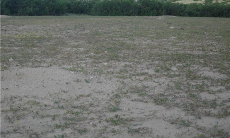
Figure 16. Purple Threeawn, Cheatgrass, Invasive species, and Bare Ground
This plant community develops through excessive, season-long herbivory. This is especially prevalent on small acreage properties and areas occupied by prairie dog towns. Blue grama may persist in small amounts. Introduced species such as spotted knapweed (Centaurea stoebe ssp. micranthos), cheatgrass (Bromus tectorum), and Russian thistle (Salsola sp.) are present. Litter levels are extremely low. Erosion is evident where flow paths are continuous. Rills may occur on steeper slopes. Wind-scoured areas may be apparent on knolls or unprotected areas. The nutrient cycle, water cycle, and overall energy flow are greatly impaired. Organic matter and carbon reserves are greatly reduced. This community is not stable and desertification is obvious. This community may also be created where severe erosion has occurred from disturbances such as tillage, over-lot grading, and road cuts. Total annual production is 400 pounds per acre (air-dry) during an average precipitation year and ranges from 100 to 700.
Resilience management. Light herbivory maintains this community.
Dominant plant species
-
plains pricklypear (Opuntia polyacantha), shrub
-
rubber rabbitbrush (Ericameria nauseosa ssp. nauseosa var. nauseosa), shrub
-
cheatgrass (Bromus tectorum), grass
-
purple threeawn (Aristida purpurea), grass
-
Russian thistle (Salsola), other herbaceous
-
spotted knapweed (Centaurea stoebe ssp. micranthos), other herbaceous
Figure 17. Plant community growth curve (percent production by month). CO4923, Snakeweed, Pioneer Annual/Perennials, Bare Ground; MLRA 49. Warm/cool season, annual/perennial forbs.
| Jan | Feb | Mar | Apr | May | Jun | Jul | Aug | Sep | Oct | Nov | Dec |
|---|---|---|---|---|---|---|---|---|---|---|---|
| J | F | M | A | M | J | J | A | S | O | N | D |
| 5 | 10 | 20 | 25 | 30 | 10 |
Transition T1A
State 1 to 2
Continuous defoliation without adequate recovery periods. Interruption of the natural fire regime.
Constraints to recovery. Lack of adequate growing season precipitation exacerbates this transition.
Context dependence. Fluctuations in local growing season precipitation patterns can significantly affect the response of the local vegetative community.
Restoration pathway R2A
State 2 to 1
Long term prescribed grazing with adequate recovery periods coupled with appropriate stocking enables restoration to the Reference state. Appropriately timed prescribed fire accelerates this.
Context dependence. The local growing season precipitation patterns greatly influence the success of the recovery effort. If restoration from remnant native vegetation isn't feasible, re-introduction of the desired species may be required.
Conservation practices
| Prescribed Burning | |
|---|---|
| Prescribed Grazing | |
| Range Planting |
Transition T2A
State 2 to 3
Continuous defoliation without adequate recovery periods. Interruption of the natural fire regime.
Constraints to recovery. Lack of adequate growing season precipitation.
Context dependence. Fluctuations in local growing season precipitation patterns significantly affect the response of the local vegetative community.
Restoration pathway R3A
State 3 to 1
Long term prescribed grazing with adequate recovery periods coupled with appropriate stocking enables restoration to the Reference state. Appropriately timed prescribed fire accelerates this restoration.
Context dependence. An adequate re-vegetation source must be available, otherwise re-seeding the desirable native species may be required. This process may take more than 40 years. The local growing season precipitation patterns greatly influence the success of the recovery effort. Weed management practices and re-introduction of some of the native vegetation may also be required.
Conservation practices
| Prescribed Burning | |
|---|---|
| Prescribed Grazing | |
| Range Planting | |
| Invasive Plant Species Control |
Additional community tables
Table 10. Community 1.1 plant community composition
| Group | Common name | Symbol | Scientific name | Annual production (lb/acre) | Foliar cover (%) | |
|---|---|---|---|---|---|---|
|
Grass/Grasslike
|
||||||
| 1 | Grass/Grasslike | 850–1705 | ||||
| western wheatgrass | PASM | Pascopyrum smithii | 210–510 | 20–35 | ||
| blue grama | BOGR2 | Bouteloua gracilis | 105–195 | 10–15 | ||
| green needlegrass | NAVI4 | Nassella viridula | 50–125 | 5–15 | ||
| big bluestem | ANGE | Andropogon gerardii | 85–120 | 5–15 | ||
| sideoats grama | BOCU | Bouteloua curtipendula | 35–65 | 3–10 | ||
| sun sedge | CAINH2 | Carex inops ssp. heliophila | 10–65 | 1–10 | ||
| needle and thread | HECOC8 | Hesperostipa comata ssp. comata | 10–65 | 1–10 | ||
| prairie Junegrass | KOMA | Koeleria macrantha | 10–65 | 1–10 | ||
| mountain muhly | MUMO | Muhlenbergia montana | 35–65 | 3–10 | ||
| little bluestem | SCSC | Schizachyrium scoparium | 35–65 | 3–10 | ||
| switchgrass | PAVI2 | Panicum virgatum | 10–40 | 1–5 | ||
| Grass, perennial | 2GP | Grass, perennial | 0–40 | 0–5 | ||
| muttongrass | POFE | Poa fendleriana | 10–40 | 1–5 | ||
| Sandberg bluegrass | POSE | Poa secunda | 10–40 | 1–5 | ||
| Canada wildrye | ELCA4 | Elymus canadensis | 10–25 | 1–5 | ||
| Geyer's sedge | CAGE2 | Carex geyeri | 10–25 | 1–5 | ||
| squirreltail | ELEL5 | Elymus elymoides | 0–15 | 0–5 | ||
| purple threeawn | ARPU9 | Aristida purpurea | 0–15 | 0–5 | ||
| sand dropseed | SPCR | Sporobolus cryptandrus | 0–15 | 0–5 | ||
| sixweeks fescue | VUOC | Vulpia octoflora | 0–15 | 0–5 | ||
| Indian ricegrass | ACHY | Achnatherum hymenoides | 0–15 | 0–5 | ||
|
Forb
|
||||||
| 2 | Forbs | 140–275 | ||||
| scarlet globemallow | SPCO | Sphaeralcea coccinea | 15–30 | 1–5 | ||
| hairy false goldenaster | HEVI4 | Heterotheca villosa | 15–30 | 1–5 | ||
| dotted blazing star | LIPU | Liatris punctata | 15–30 | 1–5 | ||
| lacy tansyaster | MAPIP | Machaeranthera pinnatifida ssp. pinnatifida | 15–30 | 1–5 | ||
| slimflower scurfpea | PSTE5 | Psoralidium tenuiflorum | 15–30 | 1–5 | ||
| upright prairie coneflower | RACO3 | Ratibida columnifera | 15–30 | 1–5 | ||
| Forb, perennial | 2FP | Forb, perennial | 15–30 | 1–5 | ||
| Cuman ragweed | AMPS | Ambrosia psilostachya | 15–30 | 1–5 | ||
| white sagebrush | ARLU | Artemisia ludoviciana | 15–30 | 1–5 | ||
| Drummond's milkvetch | ASDR3 | Astragalus drummondii | 15–30 | 1–5 | ||
| purple prairie clover | DAPUP | Dalea purpurea var. purpurea | 15–30 | 1–5 | ||
| American vetch | VIAM | Vicia americana | 15–30 | 1–5 | ||
| red dome blanketflower | GAPI | Gaillardia pinnatifida | 0–15 | 0–5 | ||
| rosy pussytoes | ANRO2 | Antennaria rosea | 0–15 | 0–5 | ||
| tarragon | ARDR4 | Artemisia dracunculus | 0–15 | 0–5 | ||
| textile onion | ALTE | Allium textile | 0–15 | 0–5 | ||
| threadleaf ragwort | SEFLF | Senecio flaccidus var. flaccidus | 0–15 | 0–5 | ||
| prairie spiderwort | TROC | Tradescantia occidentalis | 0–15 | 0–5 | ||
|
Shrub/Vine
|
||||||
| 3 | Shrubs | 110–220 | ||||
| fourwing saltbush | ATCA2 | Atriplex canescens | 15–75 | 1–10 | ||
| winterfat | KRLA2 | Krascheninnikovia lanata | 15–75 | 1–10 | ||
| rubber rabbitbrush | ERNA10 | Ericameria nauseosa | 15–30 | 1–5 | ||
| Shrub (>.5m) | 2SHRUB | Shrub (>.5m) | 15–30 | 1–5 | ||
| prairie sagewort | ARFR4 | Artemisia frigida | 15–30 | 1–5 | ||
| broom snakeweed | GUSA2 | Gutierrezia sarothrae | 0–15 | 0–1 | ||
| plains pricklypear | OPPO | Opuntia polyacantha | 0–15 | 0–1 | ||
| prairie rose | ROAR3 | Rosa arkansana | 0–15 | 0–1 | ||
| soapweed yucca | YUGL | Yucca glauca | 0–15 | 0–1 | ||
Interpretations
Animal community
Wildlife Interpretations:
The diversity of grasses, forbs, and shrubs found in the various plant communities on this ecological site provide habitat for a large number of wildlife species. These species are reflective of the transitional nature of the site, situated between the forested habitats in MLRA 48A and the grassland habitats of MLRA 67B. Historically, large grazers that influenced these plant communities were elk, mule deer, and possibly bison. Changes in the composition of the plant community when moving from Community 1.1 to other communities on this ecological site may result in dramatic species shifts in the bird population. The friable soils make this community attractive to reptiles and burrowing mammals. The occasional wetland, riparian area, spring, or stock pond found on this ecological site provides essential seasonal water needed for reproductive habitat by amphibians. Because of a lack of permanent water, fish are not commonly expected on this site.
Reference state, Western Wheatgrass, Blue Grama, Winterfat, and Fourwing Saltbush plant community:
The balance of grasses, forbs, and shrubs in this community provide habitat for a variety of vertebrate species. Pollinators are attracted to the forbs, while birds such as black-billed magpies, vesper and lark sparrows, and red-tailed hawks can be found.
Reptile species expected in this plant community include western rattlesnake, western bullsnake, many-lined skink, and six-lined racerunner. The presence of desirable grasses and the topographical variations attract mule deer and elk. White-tailed jackrabbits, coyotes, northern pocket gophers, badgers, long-tailed weasels, and several species of mouse are small mammals that commonly use this site for food and cover.
At Risk Blue Grama Dominated plant community:
The reduction of forbs in this plant community reduces pollinator insect use. Sparrows and magpies are less common because of the uniformity of grass height and the reduction of shrubs. Reptiles and small mammal populations in this community resemble those found in the Western Wheatgrass, Blue Grama, Winterfat, and Fourwing Saltbush Community. Lark buntings and horned larks are more common.
Decadent Western Wheatgrass, Blue Grama, Winterfat, and Fourwing Saltbush community:
The reduction of desirable shrubs and forbs, combined with the increase in litter, results in a slight change in wildlife species when compared with the Western Wheatgrass, Blue Grama, Winterfat, and Fourwing Saltbush Community. Western rattlesnake and other reptiles using the Western Wheatgrass, Blue Grama, Winterfat, and Fourwing Saltbush Community are still present. Lark bunting and horned lark also use this plant community. Deer and elk no longer find abundant browse plants or lush forage and therefore are not likely to use this community. There is an increase in small mammals, especially mice. Raptors continue to use this community as the reduced vegetative cover facilitates aerial predation.
Altered state, Blue Grama community:
The loss of desirable shrubs and forbs results in a change in wildlife species when compared with the 1.1 community. Grasshoppers are the most common insect. Western rattlesnake and other reptiles using the 1.1 community can still be found here. Lark bunting and horned lark are more abundant and replace the vesper and lark sparrows. Raptors continue to use this community as the reduced vegetative cover facilitates aerial predation. Black-tailed prairie dogs are found here. Deer and elk are not able to meet nutritional requirements on this site.
Eroded State, Purple Threeawn, Cheatgrass, Invasive species, and Bare Ground community:
The loss of shrubs and desirable grasses and increased bare ground results in a change in wildlife species when compared with the Western Wheatgrass, Blue Grama, Winterfat, and Fourwing Saltbush community. Pollinators are attracted to the annuals in this community. Western rattlesnake and other reptiles using the Western Wheatgrass, Blue Grama, Winterfat, and Fourwing Saltbush communities are still present. Reduced populations of lark bunting and horned lark continue to use this plant community. Small mammals, especially mice, are found in this community. Raptors continue to use this community as the reduced vegetative cover facilitates aerial predation. Deer and elk are not able to meet nutritional requirements on this site.
Hydrological functions
Water is the principal factor limiting forage production on this site. Infiltration and runoff potential for this site varies from moderate to high depending on ground cover. In many cases, areas with greater than 75 percent ground cover have the greatest potential for high infiltration and lower runoff. An example of an exception would be where short grasses form a strong sod and dominate the site. Areas where ground cover is less than 50 percent have the greatest potential to have reduced infiltration and higher runoff.
Rills and gullies should not typically be present. Water flow patterns should be barely distinguishable if at all present. Pedestals are only slightly present in association with bunchgrasses. Litter typically falls in place, and signs of movement are not common. Chemical and physical crusts are rare to non-existent. Cryptogamic crusts are present but only cover one to two percent of the soil surface.
Recreational uses
The Reference state of this ecological site will provide quality recreational uses such as camping, hiking, horseback riding, and viewing of wildlife. Limited small-game and large-game hunting may also be available in more rural areas and on public land.
Wood products
Wood products are limited on this site.
Supporting information
Inventory data references
A minimum of 20 low or medium-intensity observations are required to meet verification level status. This ESD is citing NRI and 417 data to meet these minimums. Individual observations are listed in EDIT and are viewable behind the login. A corresponding tracking sheet is available in the MLRA office that links the list to the actual observations used in the analysis.
30 Confidential NRI-GL on-site data collected in Arapahoe, Douglas, Elbert, El Paso, Fremont, Huerfano, and Pueblo counties in Colorado in this ESD from 2003 to 2020 were reviewed in 2024 and accepted by Doug Whisenhunt.
Three 417 field data observations from 1968 to 1970 collected in Arapahoe and Elbert counties were analyzed in 2024 by Doug Whisenhunt.
References
-
Anderson, R.C. 1982. An evolutionary model summarizing the roles of fire, climate, and grazing animals in the origin and maintenance of grasslands. Pages 297–308 in , , and , editors. Grasses and grasslands: systematics and ecology.
-
Guyette, R.P., M.C. Stambaugh, D.C. Dey, and R. Muzika. 2012. Predicting Fire Frequency with Chemistry and Climate. Ecosystems 15:322–335.
-
US. Department of Agriculture, . 2006. Land resource regions and major land resource areas of the United States, the Caribbean, and the Pacific Basin..
Contributors
D.A. Nosal; H.A. Sprock; B.P. Berlinger, K.A. Diller
Lee A. Neve
Revised by Doug Whisenhunt
Approval
Kirt Walstad, 5/02/2025
Rangeland health reference sheet
Interpreting Indicators of Rangeland Health is a qualitative assessment protocol used to determine ecosystem condition based on benchmark characteristics described in the Reference Sheet. A suite of 17 (or more) indicators are typically considered in an assessment. The ecological site(s) representative of an assessment location must be known prior to applying the protocol and must be verified based on soils and climate. Current plant community cannot be used to identify the ecological site.
| Author(s)/participant(s) | H. A. Sprock, D. A. Nosal, B. P. Berlinger, K. A. Diller |
|---|---|
| Contact for lead author |
Kimberly Diller, Ecological Site Specialist NRCS Pueblo MLRA Soil Survey 200 S. Santa Fe Ave Pueblo, CO 81003 (719) 543-8386, Ext 125 kimberly.diller@co.usda.gov |
| Date | 09/09/2013 |
| Approved by | Kirt Walstad |
| Approval date | |
| Composition (Indicators 10 and 12) based on | Annual Production |
Indicators
-
Number and extent of rills:
None -
Presence of water flow patterns:
Typically none, if present short and disconnected -
Number and height of erosional pedestals or terracettes:
None -
Bare ground from Ecological Site Description or other studies (rock, litter, lichen, moss, plant canopy are not bare ground):
Three (3) percent or less bare ground, with bare patches generally less than two (2) to three (3) inches in diameter. Extended drought can cause bare ground to increase upwards to five (5) to 15 percent with bare patches reaching six (6) to 12 inches in diameter. -
Number of gullies and erosion associated with gullies:
None -
Extent of wind scoured, blowouts and/or depositional areas:
None -
Amount of litter movement (describe size and distance expected to travel):
Minimal and short -
Soil surface (top few mm) resistance to erosion (stability values are averages - most sites will show a range of values):
Stability class rating anticipated to be five (5) to six (6) in interspace at soil surface. Soil surface is stabilized by decomposing organic matter. -
Soil surface structure and SOM content (include type of structure and A-horizon color and thickness):
Average SOM is two (2) to four (4) percent. Soils are deep and well drained. Surface texture ranges from loam to fine sandy loam. A-horizon ranges from four (4) to 10 inches in depth with brown to dark grayish brown color and a weak to medium sub-angular blocky parting to a moderate fine granular structure. -
Effect of community phase composition (relative proportion of different functional groups) and spatial distribution on infiltration and runoff:
Cover from sod forming grasses, bunchgrasses, forbs, and shrubs reduce bare ground. Raindrop impact is reduced as well as overland flow, providing increased time for infiltration to occur. Dense stands of blue grama can limit infiltration due to high root densities. Extended drought may reduce short and mid-statured bunchgrass basal cover resulting in decreased infiltration and increased runoff following intense storms. -
Presence and thickness of compaction layer (usually none; describe soil profile features which may be mistaken for compaction on this site):
None -
Functional/Structural Groups (list in order of descending dominance by above-ground annual-production or live foliar cover using symbols: >>, >, = to indicate much greater than, greater than, and equal to):
Dominant:
cool season mid rhizomatous >Sub-dominant:
cool season mid bunchgrass/grasslikes > warm season tallgrass > shrubs = warm season shortgrass > warm season mid bunchgrass = other forbs >= leguminous forbsOther:
Additional:
-
Amount of plant mortality and decadence (include which functional groups are expected to show mortality or decadence):
Typically minimal. Expect slightly more bunchgrass mortality during and following drought. Lack of disturbance will increase occurrence of decadence. -
Average percent litter cover (%) and depth ( in):
The average litter cover is 35 to 50 percent at the 0.25 inch depth. Litter cover during and following extended drought ranges from 15 to 25 percent. -
Expected annual annual-production (this is TOTAL above-ground annual-production, not just forage annual-production):
1,100 lbs/ac low precipitation years; 1,700 lbs/ac average precipitation years; 2,200 lbs/ac above average precipitation years. After extended drought or the first growing season following wildfire, production may be significantly reduced by 300-500 lbs/ac or more. -
Potential invasive (including noxious) species (native and non-native). List species which BOTH characterize degraded states and have the potential to become a dominant or co-dominant species on the ecological site if their future establishment and growth is not actively controlled by management interventions. Species that become dominant for only one to several years (e.g., short-term response to drought or wildfire) are not invasive plants. Note that unlike other indicators, we are describing what is NOT expected in the reference state for the ecological site:
Invasive plants should not occur in reference plant community. Annuals may temporarily occupy the site following extended fire or drought if a seed source is available. -
Perennial plant reproductive capability:
The only limitations are weather-related, wildfire, natural disease, and insects that may temporarily reduce reproductive capability.
Print Options
Sections
Font
Other
The Ecosystem Dynamics Interpretive Tool is an information system framework developed by the USDA-ARS Jornada Experimental Range, USDA Natural Resources Conservation Service, and New Mexico State University.
Click on box and path labels to scroll to the respective text.
Ecosystem states
| R2A | - | Prescribed Grazing. Prescribed Burning. Range Planting. |
|---|---|---|
| R3A | - | Prescribed Grazing. Prescribed Burning. Range Planting. Invasive Plant Species Control. |
State 1 submodel, plant communities
| 1.2A | - | Prescribed Grazing. Prescribed Burning. |
|---|---|---|
| 1.3A | - | Prescribed Grazing. Prescribed Burning. |