
Natural Resources
Conservation Service
Ecological site R049XD202CO
Loamy Foothill 11-14 PZ
Last updated: 3/10/2025
Accessed: 02/10/2026
General information
Provisional. A provisional ecological site description has undergone quality control and quality assurance review. It contains a working state and transition model and enough information to identify the ecological site.
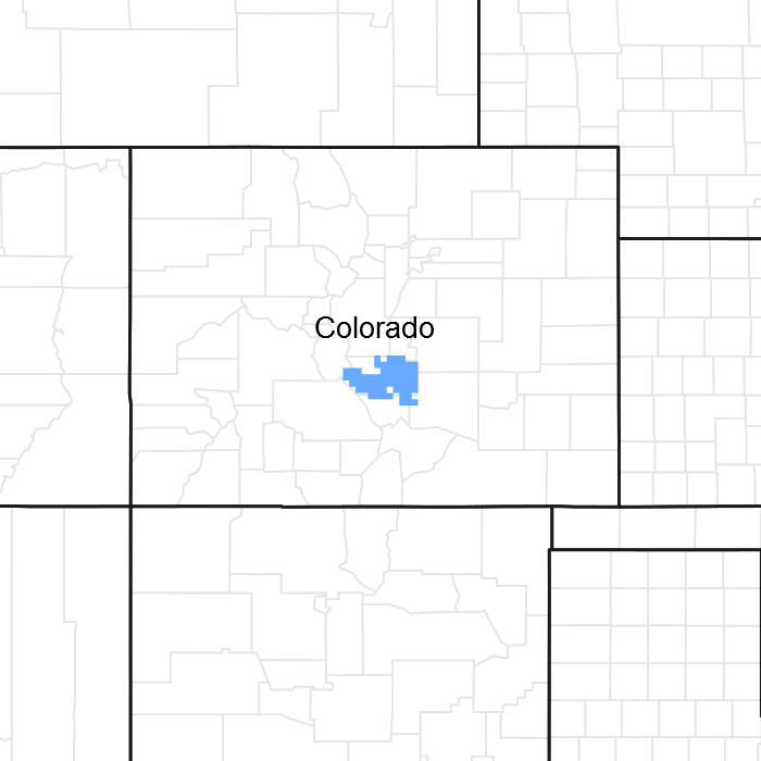
Figure 1. Mapped extent
Areas shown in blue indicate the maximum mapped extent of this ecological site. Other ecological sites likely occur within the highlighted areas. It is also possible for this ecological site to occur outside of highlighted areas if detailed soil survey has not been completed or recently updated.
MLRA notes
Major Land Resource Area (MLRA): 049X–Southern Rocky Mountain Foothills
MLRA 49 comprises approximately 11,130 square miles running north to south, from south-central Wyoming (27 percent), the length of the Front Range of Colorado (58%), and into north-central New Mexico (15 percent). Almost half of this area occurs in the Southern Rocky Mountains and Wyoming Basin Provinces in the Rocky Mountain system. The remainder is in the Colorado Pediment, Raton, and High Plains Section of the Great Plains Province of the Interior Plains. The northern part consists of the Laramie Mountains. The central and southern parts generally are bounded on the east by the Great Plains and on the west by the Southern Rocky Mountains (excerpts from USDA Ag. H.B. 296). Average elevation ranges from 5,000 to 8,000 feet. Mean Annual Precipitation ranges from 10 to 22 inches across the entire MLRA 49.
Due to the extent of MLRA 49, approximately 530 miles north to south, it was logical to describe it at the Land Resource Unit (LRU) level. LRU 49D (shaded portion of location map) describes the drier portion of MLRA 49 (11-14 inches P.Z.) of the Arkansas River, including the Royal Gorge. LRU 49D begins at Fort Carson (south of Colorado Springs) and extends through Canon City, west along the Upper Arkansas River Canyon to Salida. The southern extent ends at the Fremont/Custer County line near Wetmore. There is an isolated patch of 49D in Huerfano County near Gardner. The majority of the LRU occurs in Fremont County.
Ecological site concept
The 49D Loamy Foothill was drafted from the existing Loamy Foothill Range Site (49BY202CO, November 1989). The concept was expanded based on soil temperature and moisture regimes, climate, and geology. This site occurs on fans, fan remnants and swales on loamy to fine loamy soils derived from alluvium. It is a Western Wheatgrass - Blue grama - Winterfat community in the Pinyon-Juniper Zone.
Similar sites
| EX049X04X208 |
Clayey Foothill MLRA 49 LRU D Clayey Foothill ecological site is very similar to Loamy Foothill with lower total annual production, and a higher cool season grass component. Soil texture on Clayey Foothill is higher clay content on the surface and subsurface horizons. |
|---|
Table 1. Dominant plant species
| Tree |
(1) Juniperus monosperma |
|---|---|
| Shrub |
(1) Krascheninnikovia lanata |
| Herbaceous |
(1) Pascopyrum smithii |
Physiographic features
The dominant landforms applicable to this ecological site are fans, fan remnants and hills. The aspect has no influence on this site. The site occurs within an elevation range of 5,200 to 7,000 feet with slopes ranging from 0 to 10 percent. The site occurs in an upland position and is unaffected by a water table, flooding or water ponding.
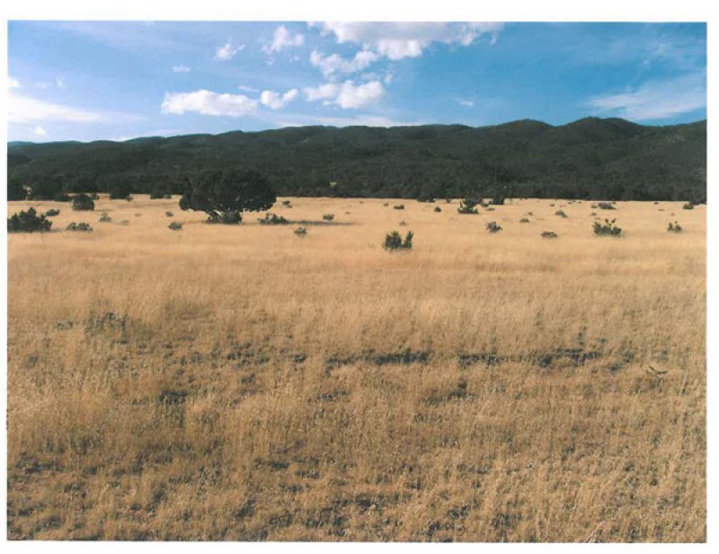
Figure 2. Loamy Foothill
Table 2. Representative physiographic features
| Landforms |
(1)
Fan
(2) Fan remnant (3) Hill |
|---|---|
| Flooding frequency | None |
| Ponding frequency | None |
| Elevation | 5,200 – 7,000 ft |
| Slope | 10% |
| Ponding depth |
Not specified |
| Water table depth | 60 in |
| Aspect | Aspect is not a significant factor |
Climatic features
The mean average annual precipitation varies from 11 to 14 inches per year depending on location and ranges from 5 inches to over 21 inches per year. Approximately 50 to 75 percent of the annual precipitation occurs during the growing season from mid-May to late-September. The Rocky Mountains to the west intercept much of the precipitation from Pacific storms during the winter. Snowfall averages 36 inches annually. Wind speeds average 9.4 miles per hour annually. Daytime winds are generally stronger than nighttime and occasional strong storms may bring brief periods of high winds with gusts to more than 70 miles per hour typically from the southwest.
The average length of the growing season is 160 days, but varies from 131 to 182 days. The average date of first freeze in the fall is September 26, and the last freeze in the spring is about May 9. July is the hottest month and January is the coldest. Summer temperatures are moderate, with average highs in the low 80s and occasionally reaching the high 80s. Summer nights are comfortably cool, with lows averaging in the low 50s. Higher elevations can receive a dusting of snow as early as September. Summer humidity is low with moderate evaporation rates.
Cool season plants generally begin growth from April 15 to May 1. Southern exposures can exhibit cool season growth as early as March 15. Native warm season plants typically begin growth about May 15 to June 1 and continue to about August 1. Regrowth of cool season plants occurs in September of most years, depending on soil moisture availability.
Table 3. Representative climatic features
| Frost-free period (average) | 131 days |
|---|---|
| Freeze-free period (average) | 156 days |
| Precipitation total (average) | 13 in |
Figure 3. Monthly precipitation range
Figure 4. Monthly average minimum and maximum temperature
Figure 5. Annual precipitation pattern
Figure 6. Annual average temperature pattern
Influencing water features
None
Soil features
The soils of this site are very deep to moderately deep. Typically they are well drained with moderate to slow permeability. They formed in alluvium from mixed sources on fans, terraces and in drainageways. Available water capacity is high in deep and very deep soils. The surface layer ranges from 0 to 25 inches and is typically loam or fine sandy loam but may include clay loam and silty clay loam. The pH is slightly acid to moderately alkaline in the surface and subsoil. It is neutral to moderately alkaline in the substratum. The soil moisture regime is ustic aridic but ranges to aridic ustic in areas with higher moisture. The soil temperature regime is mesic but ranges to frigid at higher elevations.
The Reference Plant Community should show slight to no evidence of rills; wind scoured areas or pedestalled plants. There are typically no water flow patterns but if present they are short and disconnected. The soil surface is stable and intact. Sub-surface soil layers are non-restrictive to water movement and root penetration. Stability class rating anticipated to be 5-6 in interspace at soil surface. Soil surface is stabilized by decomposing organic matter. Biological crusts (lichens, algae, cyanobacteria, mosses) may be present on or just below soil surface.
Major soil series correlated to this ecological site include: Neville, Nunn and Potts.
Table 4. Representative soil features
| Parent material |
(1)
Alluvium
–
sandstone
|
|---|---|
| Surface texture |
(1) Loam (2) Clay loam (3) Fine sandy loam |
| Family particle size |
(1) Loamy |
| Drainage class | Well drained |
| Permeability class | Slow to moderate |
| Soil depth | 20 – 72 in |
| Surface fragment cover <=3" | 25% |
| Surface fragment cover >3" | 15% |
| Available water capacity (0-40in) |
4 – 9 in |
| Calcium carbonate equivalent (0-40in) |
15% |
| Electrical conductivity (0-40in) |
4 mmhos/cm |
| Sodium adsorption ratio (0-40in) |
5 |
| Soil reaction (1:1 water) (0-40in) |
6.6 – 8.4 |
| Subsurface fragment volume <=3" (Depth not specified) |
35% |
| Subsurface fragment volume >3" (Depth not specified) |
15% |
Ecological dynamics
This site developed with occasional fires being part of the ecological processes. It is believed that the fires were historically infrequent, randomly distributed, and started by lightning at various times throughout the growing season. Early human inhabitants were also likely to start fires for various reasons (deliberately or accidentally). Both of these types of fire events likely impacted the site by leaving mosaic vegetation patterns. The impact of fire over the past 50 years has been relatively insignificant due to wildfire suppression and the lack of acceptance of prescribed fire as a management tool.
Drought and insects/disease cycles historically have had a major impact upon the vegetation. The species composition changes according to the duration and severity of the drought cycle.
Deterioration of this site, due to continuous grazing (without adequate recovery periods), will cause blue grama, galleta, and broom snakeweed to increase. Blue grama will eventually form a sodbound community if continuous grazing is not reversed. Cool season grasses such as western wheatgrass, New Mexico feathergrass, and green needlegrass will decrease in frequency and production as well as key shrubs such as fourwing saltbush and winterfat. American vetch and other highly palatable forbs will decrease. Threeawn, snakeweed, annuals and bare ground increase under heavy continuous grazing or long-term non-use. Long term continuous grazing by livestock or wildlife, long term non-use and absence of fire promote the increase/encroachment of one-seed juniper and/or pinyon. Much of this ecological site has been converted to small acreage home sites.
The Reference Community has been determined by study of rangeland relic areas, areas protected from excessive disturbance, seasonal use pastures, prescribed grazing and historical accounts.
The following is a State and Transition Diagram that illustrates the states and the common plant communities that can occur on this ecological site. The pathways among communities are represented by fine-line arrows. Bold lines surrounding each state represent ecological thresholds. The bold-line arrows indicate transitions away from and restoration pathways back toward states across thresholds. The ecological processes will be discussed in more detail in the Community narrative descriptions following the diagram.
These plant communities may not represent every possibility, but they are the most prevalent and repeatable plant communities. The plant composition table shown below has been developed from the best available knowledge at the time of this revision. As more data are collected, some of these plant communities may be revised or removed, and new ones may be added to the model. None of these plant communities should necessarily be thought of as "Desired Plant Communities". Desired Plant Communities will be determined by the decision-makers and will meet the needs of the resources. The main purpose for including any description of a plant community here is to capture the current knowledge and experience at the time of this version of the Ecological Site Description.
State and transition model
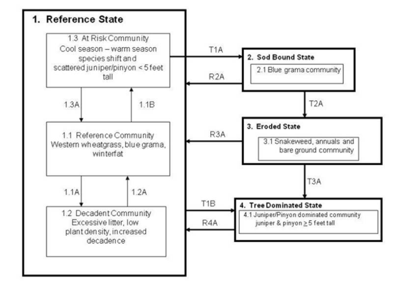
Figure 7. S&T Diagram Loamy Foothill 49D
More interactive model formats are also available.
View Interactive Models
More interactive model formats are also available.
View Interactive Models
Click on state and transition labels to scroll to the respective text
Ecosystem states
State 1 submodel, plant communities
State 2 submodel, plant communities
State 3 submodel, plant communities
State 4 submodel, plant communities
State 1
Reference
This is the Reference state for the Loamy Foothill Ecological Site in MLRA 49D.
Community 1.1
Reference Community

Figure 8. Loamy Foothill MLRA 49D Reference Plant Community
This is the interpretive plant community and is considered to be the reference community. This plant community evolved with grazing by native herbivores, fire, drought and insects/disease. It is well suited for grazing by domestic livestock and can be found on areas that are properly managed with prescribed grazing that allows for adequate recovery periods following each grazing event. The potential vegetation is about 70-85% grasses and grass-like plants, 10-15% forbs, 5-15% shrubs, and 0-2% trees. A community pathway within the historic range of variability leading to the Decadent community occurs with the lack of herbivory for long periods of time (over-rest) in the absence of fire. Another community pathway within the historic range of variability is driven by seasonal grazing disturbance with adequate recovery periods. This pathway is also driven by short periods of reduced fire frequency coupled with short term encroachment from an adjacent site. This pathway leads to an At Risk community. With the reduction of seasonal grazing disturbance and with more frequent fire and/or drought with insects and disease, the successional stage will more closely resemble the reference community. The dominant grasses include western wheatgrass and blue grama. Sub-dominant warm season grasses include little bluestem and sideoats grama. Green needlegrass, New Mexico feathergrass and sun sedge are minor cool season components. Minor grasses include Griffith wheatgrass, muttongrass, needleandthread, switchgrass, big bluestem, prairie junegrass and Sandberg bluegrass. Major forbs and shrubs include scarlet globemallow, prairie coneflower, American vetch, purple prairie clover, dotted gayfeather, winterfat, and fourwing saltbush. The Reference Community is diverse, stable, and productive. Litter is properly distributed with very little movement off-site and natural plant mortality is low. It is well suited to carbon sequestration, water yield, wildlife use by many species,and livestock use. The biotic community, nutrient cycle, water cycle and energy flow are functioning properly. This community is resistant to many disturbances except continuous grazing, long term non-use, tillage and/or development into urban or other uses. Total annual production ranges from 500 to 1,600 pounds of air-dry vegetation per acre and will average 1,050 pounds.
Figure 9. Annual production by plant type (representative values) or group (midpoint values)
Table 5. Annual production by plant type
| Plant type | Low (lb/acre) |
Representative value (lb/acre) |
High (lb/acre) |
|---|---|---|---|
| Grass/Grasslike | 300 | 805 | 1260 |
| Shrub/Vine | 50 | 105 | 160 |
| Forb | 100 | 130 | 160 |
| Tree | 0 | 10 | 20 |
| Total | 450 | 1050 | 1600 |
Figure 10. Plant community growth curve (percent production by month). CO4921, Cool season dominant, warm season subdominant; MLRA 49D; upland loamy soils. Loamy Foothill in MLRA 49D, Reference Community; Western Wheatgrass, Blue grama, fourwing saltbush; Warm/cool season, mixed short and mid grass.
| Jan | Feb | Mar | Apr | May | Jun | Jul | Aug | Sep | Oct | Nov | Dec |
|---|---|---|---|---|---|---|---|---|---|---|---|
| J | F | M | A | M | J | J | A | S | O | N | D |
| 2 | 5 | 15 | 20 | 25 | 20 | 10 | 3 |
Community 1.2
Decadent Community
This community is within the natural variability of the reference state. It is the result of reduced frequency of fire and/or long-term non-use. Plant composition resembles the reference plant community but plant density has decreased due to excessive plant litter accumulation and increased decadence of plants. Species production, plant vigor and density will decrease as non-use and fire supression persists. Excessive above ground litter limits sunlight from reaching plant crowns resulting in increased decadence of bunchgrasses. Total annual production can be extremely variable depending on length of non-use.
Community 1.3
At Risk
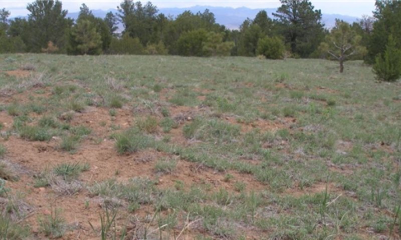
Figure 11. At Risk Community
This community is an associated successional phase within the historic variability of the Reference State. It is represented by a cool season/warm season shift in species composition. This is driven by seasonal grazing disturbance and/or drought without adequate recovery periods. The recovery period can be within the growing season after the disturbance, or for a one to two year period of time following the disturbance. For example, repeated herbivory and/or drought in the cool season without adequate recovery opportunity would cause a shift to a warm season successional stage. Conversely, repeated warm season disturbances such as herbivory and drought without adequate recovery, will cause a shift to a cool season successional stage. A scattered distribution of young pinyon and/or one-seed juniper, less than 5 feet in height, may occur with periods of reduced fire frequency coupled with short-term encroachment from an adjacent site. With more frequent fire and/or drought with insects and disease, the successional stage will more closely resemble the Reference plant community. This community is at risk of crossing an ecological threshold. The biotic integrity has been impaired due to a decreased western wheatgrass and winterfat with an increase in the amount of blue grama. Big bluestem and green needlegrass have also decreased in abundance. As a result of the shift in species composition infiltration has been negatively affected along with some impairment of energy flow. The site stability remains relatively stable. Total annual production ranges from 400 to 1,200 pounds of air-dry vegetation per acre and will average 800 pounds.
Pathway 1.1A
Community 1.1 to 1.2
A community pathway leading to the excessive litter, low plant density, increased decadence plant community occurs with the lack of native herbivory for long periods of time (over-rest) in the absence of fire. Species production, plant vigor, and density will decrease as non-use and fire suppression persists. Excessive aboveground litter limits sunlight from reaching plant crowns, and bunchgrass decadence increases.
Pathway 1.1B
Community 1.1 to 1.3


This pathway is the result of continued seasonal disturbance, and reduced fire frequency. For example, repeated herbivory and/or drought in the cool season without adequate recovery opportunity would cause a shift to a warm season successional stage. Conversely, repeated warm season disturbances such as herbivory and drought without adequate recovery, will cause a shift to a cool season successional stage. A scattered distribution of young one-seed juniper and/or pinyon (<5 feet height) may occur with periods of reduced fire frequency coupled with short term encroachment from an adjacent site.
Pathway 1.2A
Community 1.2 to 1.1
This community pathway is associated with more frequent fire and/or native herbivory. The pathway moves the decadent community successional stage toward a plant community that will more closely resemble the reference plant community.
Pathway 1.3A
Community 1.3 to 1.1


This pathway is a return to the reference community. It occurs in the absence of seasonal grazing disturbances along with normal fire and drought frequency. The pathway moves the successional stage toward a plant community that will more closely resemble the Reference Community.
State 2
Sod Bound
Green needlegrass, New Mexico feathergrass, American vetch, purple prairie clover, fourwing saltbush and winterfat have been removed. Western wheatgrass may persist in trace amounts. Blue grama dominates the community and has become "sodbound". Galleta, threeawn, sand dropseed, bottlebrush squirreltail, sixweeks fescue, plains pricklypear, walking stick cholla, broom snakeweed, and hairy goldaster have all increased. This State is resistant to change due to grazing tolerance of blue grama. A significant amount of production and diversity has been lost when compared to the Reference Community.
Community 2.1
Blue Grama Community
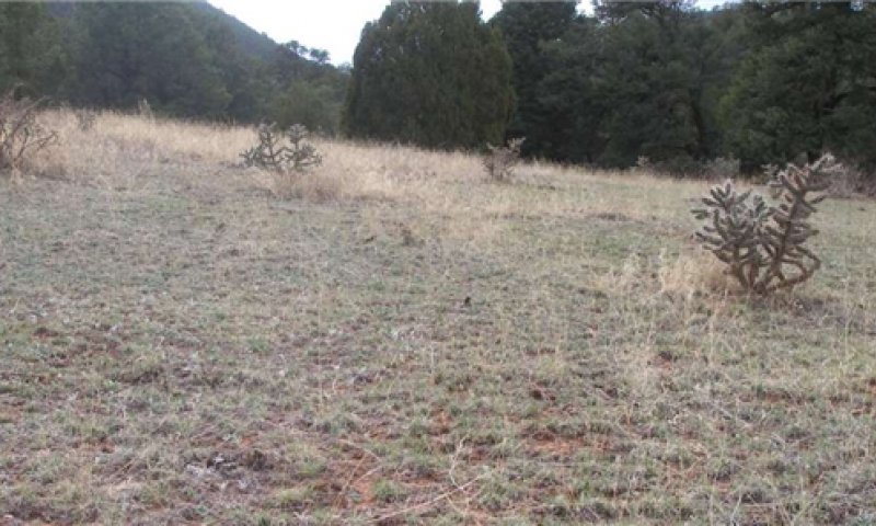
Figure 12. Sod Bound State Blue Grama Community
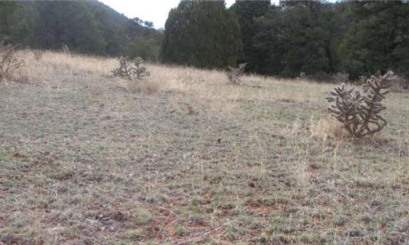
Figure 13. Loamy Fthill MLRA 49D Blue Grama Sod Community 4-17-2012
This plant community developed with continuous grazing without adequate recovery periods between grazing events. Green needlegrass, New Mexico feathergrass, American vetch, purple prairie clover, fourwing saltbush and winterfat have been removed. Western wheatgrass may persist in trace amounts. Blue grama dominates the community and has become "sodbound". Galleta, threeawn, sand dropseed, bottlebrush squirreltail, sixweeks fescue, plains pricklypear, walking stick cholla, broom snakeweed, and hairy goldaster have all increased. This plant community is resistant to change due to grazing tolerance of blue grama. A significant amount of production and diversity has been lost when compared to the HCPC. Loss of cool season grasses, winterfat, fourwing saltbush and nitrogen fixing forbs have negatively impacted energy flow and nutrient cycling. Water infiltration is reduced significantly due to the extensive shallow root system (root pan), characteristic of sodbound blue grama. Soil loss may be obvious where flow paths are connected. It will take a very long time to return this community back to the reference community with improved management. Drought expedites the transition toward the Reference Community by reduction of blue grama sod, providing new niches within the sodbound stand for recruitment. Desertification is advanced. Renovation would be very costly. Production ranges from 250 to 850 pounds of air-dry vegetation per acre per year and averages 550 pounds.
Figure 14. Plant community growth curve (percent production by month). CO4922, Blue Grama Sod, MLRA 49. Warm season dominant, shortgrass, MLRA 49.
| Jan | Feb | Mar | Apr | May | Jun | Jul | Aug | Sep | Oct | Nov | Dec |
|---|---|---|---|---|---|---|---|---|---|---|---|
| J | F | M | A | M | J | J | A | S | O | N | D |
| 2 | 12 | 30 | 35 | 18 | 3 |
State 3
Eroded
Three awn is the prominent plant on this site with blue grama persisting in localized areas. Sleepygrass, tumblegrass, and hairy tridens are common. Noxious weeds may have invaded the site.
Community 3.1
Snakeweed, Annuals and Bare Ground Community
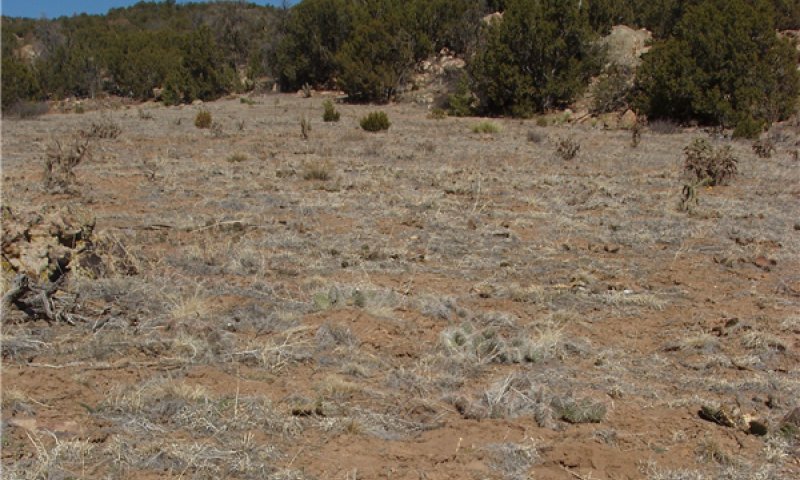
Figure 15. Snakeweed, Annuals and Bare Ground Community
This plant community develops with heavy continuous grazing or long term non-use, and/or occupation by prairie dogs. Threeawn is the dominant species but blue grama and galleta may persist in localized areas. Native invaders to this community include sleepygrass, tumblegrass, and hairy tridens. Sleepygrass commonly dominates disturbed sites while annuals such as little barley, sixweeks fescue, cheatgrass, kochia and Russian thistle have increased or invaded. Field bindweed can also be present, especially on prairie dog towns. Noxious weeds may also invade. Litter levels are extremely low, erosion is evident where flow paths are continuous, and rills may occur on steeper slopes. Pedestals and terracettes may be obvious especially in flow paths. Wind scouring may be apparent on unprotected areas. The nutrient cycle, water cycle and overall energy flow are greatly impaired. Organic matter/carbon reserves are significantly reduced and desertification is obvious. Total annual production can vary from 50 to 250 pounds of air-dry vegetation per acre and average 100 pounds per acre.
Figure 16. Plant community growth curve (percent production by month). CO4923, Snakeweed, Pioneer Annual/Perennials, Bare Ground; MLRA 49. Warm/cool season, annual/perennial forbs.
| Jan | Feb | Mar | Apr | May | Jun | Jul | Aug | Sep | Oct | Nov | Dec |
|---|---|---|---|---|---|---|---|---|---|---|---|
| J | F | M | A | M | J | J | A | S | O | N | D |
| 5 | 10 | 20 | 25 | 30 | 10 |
State 4
Tree Dominated
This state typically occurs adjacent to a juniper or pinyon seed source. Long term encroachment of one-seed juniper and pinyon has occurred. Heavy continuous grazing, lack of fire and long-term non-use and/or mechanical soil disturbance can initiate or accelerate the encroachment. A combination of prescribed grazing, brush management, insects/disease and fire are methods, or events, which can control the encroachment. The hydrologic functioning and biotic integrity of the site has been significantly impaired.
Community 4.1
Juniper and/or Pinyon Dominated Community
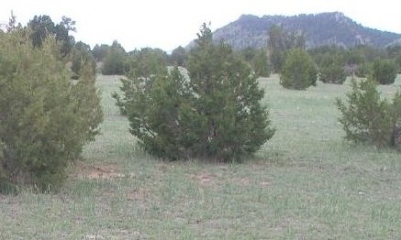
Figure 17. Pinyon and Juniper Dominated Community
This plant community is typically found adjacent to a juniper or pinyon seed source. Long term encroachment of one-seed juniper and pinyon has occurred. Heavy continuous grazing, lack of fire and long-term non-use and/or mechanical soil disturbance can initiate or accelerate the encroachment. A combination of prescribed grazing, brush management, insects/disease and fire are methods, or events, which can control the encroachment. Increased tree canopy intercept significantly impairs the water cycle. Loss of herbaceous ground cover due to increased competition from the trees will increase runoff causing soil erosion. Herbaceous production and diversity has decreased significantly. Total annual production can be extremely variable depending on tree canopy cover, but may range from 50 to 400 pounds of air-dry vegetation per acre.
Figure 18. Plant community growth curve (percent production by month). CO4924, Juniper/pinyon dominated; MLRA 49D. Juniper/pinyon MLRA 49D.
| Jan | Feb | Mar | Apr | May | Jun | Jul | Aug | Sep | Oct | Nov | Dec |
|---|---|---|---|---|---|---|---|---|---|---|---|
| J | F | M | A | M | J | J | A | S | O | N | D |
| 10 | 20 | 30 | 25 | 15 |
Transition T1A
State 1 to 2
Continuous grazing, without adequate recovery opportunity between grazing events, with or without proper stocking, will move this site across an ecological threshold to the Sod Bound State and Blue Grama Plant Community. Reduced competition from perennial grasses, forbs and shrubs allows blue grama to increase due to a higher competitive advantage. The plant community structure has been severely reduced. A biotic integrity/energy flow threshold has been crossed, causing the plant community structure to be severely reduced.
Transition T1B
State 1 to 4
Heavy continuous grazing and fire suppression, or long-term nonuse with encroachment/increase of pinyon/juniper will transition across an ecological threshold leading to the Tree Dominated State and Pinyon/Juniper Dominated Community, Pinyon & Juniper > 5 feet tall. Fire suppression due to suburban development plays a large role in having affected the ecology of the site. A hydrologic function/nutrient cycle/soil & site stability/biotic integrity threshold has been crossed.
Restoration pathway R2A
State 2 to 1
Restoration Process: Long-term prescribed grazing with adequate recovery periods following each grazing event and proper stocking over long periods of time move this plant community toward the Reference State and will eventually return to the Reference Community or associated successional plant community stages, assuming an adequate seed/vegetative source is available. This transition is a slow process, which may take greater than 40 years to accomplish. Drought will expedite the restoration process.
Transition T2A
State 2 to 3
Heavy continuous grazing or long-term continuous grazing without adequate recovery periods following each grazing event, or long-term non-use will shift this plant community (or any herbaceous dominated plant community) toward the Eroded State and the Snakeweed, Annuals, Bare Ground Plant Community. This transition may take greater than 40 years. Erosion and loss of organic matter/carbon reserves are concerns because a hydrologic function/soil stability threshold is crossed.
Restoration pathway R3A
State 3 to 1
Very Long-term prescribed grazing with adequate recovery periods between each grazing event and proper stocking can eventually restore this community back to the Reference State, assuming an adequate seed/vegetative source is available. This restoration will take a long time (80 years or more) to achieve.
Transition T3A
State 3 to 4
Fire suppression with encroachment will transition across an ecological threshold leading to the Juniper/Pinyon Dominated State and the Juniper/Pinyon Dominated Community, (J/P > 5 Feet tall). Fire suppression due to suburban development plays a large role in the ecology of the site.
Restoration pathway R4A
State 4 to 1
Restoration Process: Brush management, insects/disease, fire and/or long term prescribed grazing with adequate recovery opportunity between each grazing events and proper stocking will restore this State and Plant Community back to the reference community or associated successional stages assuming an adequate seed/vegetative source is available. This restoration is a very slow process, which may take greater than 80 years to accomplish.
Additional community tables
Table 6. Community 1.1 plant community composition
| Group | Common name | Symbol | Scientific name | Annual production (lb/acre) | Foliar cover (%) | |
|---|---|---|---|---|---|---|
|
Grass/Grasslike
|
||||||
| 1 | Grass/Grasslike | 475–1200 | ||||
| blue grama | BOGR2 | Bouteloua gracilis | 158–263 | – | ||
| western wheatgrass | PASM | Pascopyrum smithii | 158–263 | – | ||
| James' galleta | PLJA | Pleuraphis jamesii | 11–53 | – | ||
| little bluestem | SCSC | Schizachyrium scoparium | 32–53 | – | ||
| New Mexico feathergrass | HENE5 | Hesperostipa neomexicana | 11–53 | – | ||
| Grass, perennial | 2GP | Grass, perennial | 11–53 | – | ||
| big bluestem | ANGE | Andropogon gerardii | 32–53 | – | ||
| sun sedge | CAINH2 | Carex inops ssp. heliophila | 11–32 | – | ||
| sideoats grama | BOCU | Bouteloua curtipendula | 0–32 | – | ||
| muttongrass | POFE | Poa fendleriana | 11–32 | – | ||
| Sandberg bluegrass | POSE | Poa secunda | 11–32 | – | ||
| switchgrass | PAVI2 | Panicum virgatum | 0–21 | – | ||
| sand dropseed | SPCR | Sporobolus cryptandrus | 11–21 | – | ||
| needle and thread | HECOC8 | Hesperostipa comata ssp. comata | 11–21 | – | ||
| prairie Junegrass | KOMA | Koeleria macrantha | 11–21 | – | ||
| mountain muhly | MUMO | Muhlenbergia montana | 0–21 | – | ||
| Canada wildrye | ELCA4 | Elymus canadensis | 11–21 | – | ||
| squirreltail | ELEL5 | Elymus elymoides | 11–21 | – | ||
| threeawn | ARIST | Aristida | 11–21 | – | ||
| Indian ricegrass | ACHY | Achnatherum hymenoides | 0–11 | – | ||
| hairy woollygrass | ERPI5 | Erioneuron pilosum | 0–11 | – | ||
| green needlegrass | NAVI4 | Nassella viridula | 0–11 | – | ||
| sixweeks fescue | VUOC | Vulpia octoflora | 0–11 | – | ||
|
Forb
|
||||||
| 2 | Forbs | 145–250 | ||||
| tarragon | ARDR4 | Artemisia dracunculus | 11–21 | – | ||
| white sagebrush | ARLU | Artemisia ludoviciana | 11–21 | – | ||
| purple prairie clover | DAPUP | Dalea purpurea var. purpurea | 11–21 | – | ||
| hairy false goldenaster | HEVI4 | Heterotheca villosa | 11–21 | – | ||
| Forb, perennial | 2FP | Forb, perennial | 11–21 | – | ||
| dotted blazing star | LIPU | Liatris punctata | 11–21 | – | ||
| slimflower scurfpea | PSTE5 | Psoralidium tenuiflorum | 11–21 | – | ||
| upright prairie coneflower | RACO3 | Ratibida columnifera | 11–21 | – | ||
| scarlet globemallow | SPCO | Sphaeralcea coccinea | 11–21 | – | ||
| American vetch | VIAM | Vicia americana | 11–21 | – | ||
| threadleaf ragwort | SEFLF | Senecio flaccidus var. flaccidus | 0–11 | – | ||
| lacy tansyaster | MAPIP | Machaeranthera pinnatifida ssp. pinnatifida | 0–11 | – | ||
| beardtongue | PENST | Penstemon | 0–11 | – | ||
| Cuman ragweed | AMPS | Ambrosia psilostachya | 0–11 | – | ||
| rosy pussytoes | ANRO2 | Antennaria rosea | 0–11 | – | ||
| stickseed | LAPPU | Lappula | 0–11 | – | ||
| Lewis flax | LILE3 | Linum lewisii | 0–11 | – | ||
| Drummond's milkvetch | ASDR3 | Astragalus drummondii | 0–11 | – | ||
| plains milkweed | ASPU | Asclepias pumila | 0–11 | – | ||
| bastard toadflax | COUM | Comandra umbellata | 0–11 | – | ||
| James' cryptantha | CRCIJ | Cryptantha cinerea var. jamesii | 0–11 | – | ||
|
Shrub/Vine
|
||||||
| 3 | Shrubs | 90–250 | ||||
| winterfat | KRLA2 | Krascheninnikovia lanata | 11–53 | – | ||
| fourwing saltbush | ATCA2 | Atriplex canescens | 11–32 | – | ||
| rabbitbrush | CHRYS9 | Chrysothamnus | 11–21 | – | ||
| plains pricklypear | OPPO | Opuntia polyacantha | 11–21 | – | ||
| prairie rose | ROAR3 | Rosa arkansana | 11–21 | – | ||
| Shrub (>.5m) | 2SHRUB | Shrub (>.5m) | 11–21 | – | ||
| prairie sagewort | ARFR4 | Artemisia frigida | 11–21 | – | ||
| soapweed yucca | YUGL | Yucca glauca | 0–11 | – | ||
| spinystar | ESVIV | Escobaria vivipara var. vivipara | 0–11 | – | ||
| broom snakeweed | GUSA2 | Gutierrezia sarothrae | 0–11 | – | ||
|
Tree
|
||||||
| 4 | Trees | 0–21 | ||||
| oneseed juniper | JUMO | Juniperus monosperma | 0–11 | – | ||
| twoneedle pinyon | PIED | Pinus edulis | 0–11 | – | ||
Interpretations
Animal community
Wildlife Interpretations:
The diversity of grasses, forbs, and shrubs found in the various plant communities on this ecological site provide habitat for a large number of wildlife species. The wildlife species found on this site are reflective of the transitional nature of the site, situated between the forested habitats in MLRA 48A with grassland habitats in MLRA 69. Historic large grazers that influenced these plant communities were elk, mule deer, and possibly bison. Changes in the composition of the plant community when moving from the Reference Community to other communities on this ecological site may result in dramatic species shifts in the bird community. The friable soils make this community attractive to reptiles and burrowing mammals. The occasional wetland, riparian area, spring, or stock pond found on this ecological site provides essential seasonal water needed for reproductive habitat by amphibians. Because of a lack of permanent water, fish are not commonly expected on this ecological site.
Refernce Plant Community; Western Wheatgrass, Blue Grama, winterfat Plant Community:
The balance of grasses, forbs, and shrubs in this community provide habitat for a variety of vertebrate species. Pollinators are attracted to the forbs expected in this community. The fine textured soils are not attractive to many reptile species, however, western rattlesnake, bullsnake, coachwhip, and six-lined racerunner may use the site to meet all or parts of their life requisites. Birds such as black-billed magpie, vesper and lark sparrow, and red-tailed hawks will use this community. The presence of desirable grasses and the topographical variations attract mule deer and elk to this community to some degree. White-tailed jackrabbit, coyote, Northern pocket gopher, badger, long-tailed weasel, and several species of mice are small mammals that commonly use this plant community for food and cover.
Blue Grama Sod Plant Community:
The loss of forbs in this plant community will reduce pollinator insect use. Reptiles in this community will be similar to the Reference Plant Community species. The sparrows will be less likely here because of the loss of shrubs and the uniformity of grass height in this community. Deer will no longer find browse plants. Small mammals will still use the site.
Broom Snakeweed, Annuals and Bare Ground Plant Community:
The loss of desirable shrubs and forbs, combined with the increase in bare ground will result in a change in wildlife species when compared with the Reference Plant Community. Grasshoppers will be the common insect. Western rattlesnake and other reptiles using the Reference Plant Community will still be found here. Lack of food and cover will result in less use by black-billed magpie and the sparrows expected in the Reference Plant Community, however use by hawks will probably continue because it will be easy to spot prey in this community. Gunnison''''''''s prairie dog will use the site. Deer and elk will not be able to meet their life requisites on this site.
Juniper and/or Pinyon (>5 feet high) Plant Community:
The vegetative differences between the grass dominated HCPC plant community and this woody plant community will result in major differences in wildlife use between the two communities. The increased woody cover will attract Foothills bird species such as pinyon jay, green-tailed towhee, black-headed grosbeak, dark-eyed junco, and Virginia''''''''s warbler, and, if adequate water is available, wild turkey would be found in this community. The woody cover improves escape and hiding cover for species such as mule deer, elk, and black bear. Mountain lion may be attracted to the site as a source of prey species such as mule deer. Bobcat will find the site attractive because of the dense brushy cover. Bighorn sheep may be found in canyons and rock outcrop areas in this plant community. Six-lined racerunner and badger will stop using this site because of the dense woody vegetation.
Recreational uses
The Reference State of this ecological site will provide quality recreational uses such as small game hunting, camping, and hiking.
Wood products
The Tree Dominated state of this ecological site will provide fence posts and fire wood.
Supporting information
Inventory data references
Inventory data is based on vegetation and soil sampling of locations representing the ecological site concept. Other information incorporated into the Ecological Site is from long-term observations,range inventory data from experienced range-trained personnel, literature review, and historical accounts of vegetation present at the time of settlement. Data collection for this Ecological Site was done in conjunction with the progressive soil surveys within the Southern Rocky Mountain Foothills (MLRA 49) of Colorado. It has been mapped and correlated with soils in the following soil surveys: Fremont and Huerfano counties.
Other references
Data collection for this ecological site was done in conjunction with the progress soil surveys within the Southern Rocky Mountain Foothills (MLRA 49) of Colorado. It has been mapped and correlated with soils in the following soil surveys: Fremont and Huerfano Counties.
Abella, Scott R. 2008. Managing Gambel Oak in southwestern ponderosa pine forests: The status of our knowledge. Faculty Publications (SEPA). Paper 349.University of Nevada, Las Vegas
Allen, Robert B., Robert K. Peet and William L. Baker. 1991. Gradient analysis of latitudinl variation in southern Rocky Mountain forests. Journal of Biogeography 18, 123-139
Banzhaf, William H., et al. 1986. Gambel Oak in Colorado''s Front Range. Potentials of noncommercial forest biomass for energy. Excerpt from Univ. of Ariz. School of Renewable Natural Resources. Technical Bulletin No. 256
Crofutt, Geo A. 1981. Crofutt’s Grip-Sack Guide of Colorado. Johnson Publishing Company. Edited by francis B. Rizzari, Richard A. Ronzio and Elsie V. Ryland
Goodman, George J. and Cheryl A. Lawson. 1995. Retracing Major Stephen H. Long’s 1820 Expedition: The Itinerary and Botany. University of OK Press
Jackson, Donald. 1966 The journals of Zebulon Montgomery Pike with letters & related documents. Univ. of Oklahoma Press, First Edition.
NOAA Western Regional Climate Center. 2215 Raggio Parkway Reno, NV 89512 (http://www.wrcc.dri.edu)
Peet, Robert K. 1978. Forest vegetation of the Colorado Front Range; Patterns of species diversity. Vegetatio Vol. 37, 2: 65-78
Soil Survey Staff, USDA-NRCS Official Soil Series Descriptions. Available online at http://soils.usda.gov/technical/classification/osd/index.html. Accessed [April 3, 2013].
Soil Survey Staff. USDA-NRCS U.S. General Soil Map (STATSGO2). Available online at http://soildatamart.nrcs.usda.gov. Accessed [April 3, 2013].
USDA, NRCS. Grazing Lands Technology Institute, Revision 1, December 2003, issued September 1997. National Range and Pasture Handbook at http://www.co.nrcs.usda.gov/ Home / Land Use / Range & Pasture / National Range and Pasture Handbook.
USDA, NRCS. National Soil Information System, Information Technology Center, 2150 Centre Avenue, Building A, Fort Collins, CO 80526. http://nasis.nrcs.usda.gov
USDA, NRCS. 2013. The PLANTS Database (http://plants.usda.gov, 6 September 2013). National Plant Data Team, Greensboro, NC 27401-4901 USA.
USDA-NRCS Soil Survey of Fremont County Area, Colorado, Issued December, 1995 in cooperation with Colorado Agricultural Experiment Station and USDI –BLM
USDA-Soil Conservation Service (SCS). Soil Survey of Huerfano County Area, Colorado, Issued July, 1983 in cooperation with Colorado Agricultural Experiment Station
USDA-NRCS Agriculture Handbook 296, issued 2006. Land Resource Regions and Major Land Resource Areas of the United States, the Caribbean, and the Pacific Basin
Whiteley, Lee. 1999. The Cherokee Trail: Bent’s Old Fort to Fort Bridger. Denver Posse of Westerners, Inc.
Contributors
Ben P. Berlinger, Kimberly A. Diller
K. Diller
Lee A. Neve
Mike Cassell
Approval
Kirt Walstad, 3/10/2025
Rangeland health reference sheet
Interpreting Indicators of Rangeland Health is a qualitative assessment protocol used to determine ecosystem condition based on benchmark characteristics described in the Reference Sheet. A suite of 17 (or more) indicators are typically considered in an assessment. The ecological site(s) representative of an assessment location must be known prior to applying the protocol and must be verified based on soils and climate. Current plant community cannot be used to identify the ecological site.
| Author(s)/participant(s) | M. Cassell, B. Berlinger, K. Diller |
|---|---|
| Contact for lead author |
Kimberly Diller, Ecological Site Specialist USDA-NRCS, Pueblo MLRA Soil Survey 200 S. Santa Fe Ave Pueblo, CO 81003 (719) 543-8386, Ext 125 kimberly.diller@co.usda.gov |
| Date | 04/30/2008 |
| Approved by | Kirt Walstad |
| Approval date | |
| Composition (Indicators 10 and 12) based on | Annual Production |
Indicators
-
Number and extent of rills:
None. -
Presence of water flow patterns:
Typically none, if present short and disconnected. -
Number and height of erosional pedestals or terracettes:
None. -
Bare ground from Ecological Site Description or other studies (rock, litter, lichen, moss, plant canopy are not bare ground):
5% or less bare ground, with bare patches generally less than 3-6 inches in diameter. Extended drought can cause bare ground to increase upwards to 10-20% with bare patches reaching upwards to 7-15 inches in diameter. -
Number of gullies and erosion associated with gullies:
None. -
Extent of wind scoured, blowouts and/or depositional areas:
None. -
Amount of litter movement (describe size and distance expected to travel):
Minimal and short. -
Soil surface (top few mm) resistance to erosion (stability values are averages - most sites will show a range of values):
Stability class rating anticipated to be 5-6 in interspace at soil surface. Soil surface is stabilized by decomposing organic matter. Biological crusts (lichens, algae, cyanobacteria, mosses) may be present on or just below soil surface. -
Soil surface structure and SOM content (include type of structure and A-horizon color and thickness):
Average SOM is 1-3%. Soils are deep and well drained. Surface texture ranges from clay loam, loam to stony loam. A-horizon ranges from 4 to 8 inches in depth with light brownish-gray to very dark grayish-brown, or light brown to dark brown color, and a fine to medium granular to a weak to medium subangular blocky structure. -
Effect of community phase composition (relative proportion of different functional groups) and spatial distribution on infiltration and runoff:
Grass canopy from sod forming grasses and bunchgrass basal cover reduce bare ground. Raindrop impact is reduced as well as overland flow, providing increased time for infiltration to occur. Dense stands of blue grama can limit infiltration due to high root densities. Extended drought may reduce short/mid bunchgrass basal cover resulting in decreased infiltration and increased runoff following intense storms. -
Presence and thickness of compaction layer (usually none; describe soil profile features which may be mistaken for compaction on this site):
None. -
Functional/Structural Groups (list in order of descending dominance by above-ground annual-production or live foliar cover using symbols: >>, >, = to indicate much greater than, greater than, and equal to):
Dominant:
None.Sub-dominant:
cool season rhizomatous > warm season short bunchgrass > cool season mid bunchgrass/grasslikes > shrubs >Other:
Minor: warm season mid bunchgrass> forbs > warm season tall bunchgrass >leguminous forbs = warm season mid weakly rhizomatous grass
Trace: Trees > biological crustsAdditional:
-
Amount of plant mortality and decadence (include which functional groups are expected to show mortality or decadence):
Typically minimal. Expect slightly more bunchgrass mortality during and following drought. Lack of disturbance will increase occurrence of decadence. -
Average percent litter cover (%) and depth ( in):
20-30% litter cover at 0.25 inch depth. Litter cover during and following extended drought ranges from 10-15%. -
Expected annual annual-production (this is TOTAL above-ground annual-production, not just forage annual-production):
450 pounds/acre low precipitation years; 1050 pounds/acre average precipitation years; 1600 pounds/acre above average precipitation years. After extended drought or the first growing season following wildfire, production may be significantly reduced by 150 – 250 pounds/acre or more. -
Potential invasive (including noxious) species (native and non-native). List species which BOTH characterize degraded states and have the potential to become a dominant or co-dominant species on the ecological site if their future establishment and growth is not actively controlled by management interventions. Species that become dominant for only one to several years (e.g., short-term response to drought or wildfire) are not invasive plants. Note that unlike other indicators, we are describing what is NOT expected in the reference state for the ecological site:
Invasive plants should not occur in reference plant community. Cheatgrass, Russian thistle, kochia, other non-native annuals may invade following extended drought or after fire assuming a seed source is available. Sleepygrass is a native perennial grass that can invade. Oneseed juniper and Pinyon pine may encroach from other sites. -
Perennial plant reproductive capability:
The only limitations are weather-related, wildfire, natural disease, and insects that may temporarily reduce reproductive capability.
Print Options
Sections
Font
Other
The Ecosystem Dynamics Interpretive Tool is an information system framework developed by the USDA-ARS Jornada Experimental Range, USDA Natural Resources Conservation Service, and New Mexico State University.
Click on box and path labels to scroll to the respective text.