Natural Resources
Conservation Service
Ecological site R051XA006NM
Breaks
Last updated: 12/11/2024
Accessed: 02/21/2026
General information
Provisional. A provisional ecological site description has undergone quality control and quality assurance review. It contains a working state and transition model and enough information to identify the ecological site.

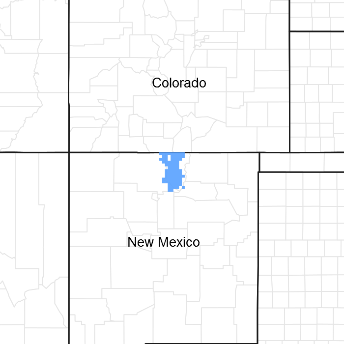
Figure 1. Mapped extent
Areas shown in blue indicate the maximum mapped extent of this ecological site. Other ecological sites likely occur within the highlighted areas. It is also possible for this ecological site to occur outside of highlighted areas if detailed soil survey has not been completed or recently updated.
MLRA notes
Major Land Resource Area (MLRA): 051X–High Intermountain Valleys
This MLRA encompasses the San Luis Valley in south central Colorado and the Taos Plateau and Taos alluvial piedmonts of north central New Mexico. As part of the northern portion of the Rio Grande Rift, the MLRA consists of large, alluvium filled basins washed down from adjacent mountain ranges. The Rio Grande River flows through this MLRA, continuing its long function of carrying mountain sediment down to the basin. Cenozoic volcanism is an extensive characteristic of the MLRA where large basalt flows with volcanic hills and domes are abundant. Ancient Lake Alamosa is a large feature within the MLRA.
Classification relationships
NRCS:
Major Land Resource Area 51, High Intermountain Valleys (United States Department of Agriculture, Natural Resources Conservation Service, 2006).
USFS:
331J – Northern Rio Grande Basin M331Ic > 331Ja - San Luis Valley, 331Jb - San Luis Hills and 331C - Mogotes
EPA:
22 - Arizona/New Mexico Plateau > 22a - San Luis Shrublands and Hills ; 22b -San Luis Alluvial Flats and Wetlands ; 22c - Salt Flats; 22e - Sand Dunes and Sand Sheets and 22f -Taos Plateau (Griffith, 2006).
USGS:
Southern Rocky Mountain Province
Ecological site concept
Soils are skeletal (>35% rock fragments). They are classified as orthents, meaning they are entisols, soils which lack horizon development. In this case it is due to steep slopes. Soil depth varies from very shallow to very deep over a lithic and paralithic contact. Surface textures range from loam to clay loam. Associated rock outcrop is common. Slope ranges from 40 percent to 80 percent.
Associated sites
| F048AY925CO |
Ponderosa Pine Forest This site occurs on hillsides, mountain-slopes, mesas, structural benches and cuestas. Slopes are 3 to 30%. Soils are moderately deep to very deep (20 to 60+ inches). Soils are derived from slope alluvium from sandstone and/or shale, colluvium from sandstone and/or shale, or residuum from sandstone and shale. Soil surface texture is a loam, clay loam, sandy loam, fine sandy loam, very stony loam, cobbly sandy loam, or very boulder sandy loam with fine textured subsurface. It has a typic ustic moisture regime. The effective precipitation ranges from 16 to 20 inches. |
|---|---|
| R048AY005NM |
Mountain Malpais This site is characterized by flat to moderately steep topography. It is frequently found where the basalt caps are present. The site’s terrain may be interrupted by extrusions of the basalt, leaving a rough or choppy appearance to the topography. Boulders on the surface are common. The dominant slope range is from 3 to 30 percent, but it some site range up to 55 percent. These soils are very shallow to shallow, and formed in debris from basalt and other volcanic rock or metamorphic rock. |
| R036XB018NM |
Stony Loam This site occurs on nearly level alluvial fans, stream terraces, plateaus, mesas and volcanic cones. The typical surface soil textures are loam or cobbly loam. It has an aridic ustic/ustic arid moisture regime and mesic temperature regime. The effective precipitation ranges from 10 to 16 inches. |
| R051XA001NM |
Loamy The Loamy site occurs on the alluvial fans, valley sides or mountain valleys on slopes less than 5 percent. The site is fine-loamy or fine-loamy over sandy or sandy-skeletal family particle size. Parent material is slope alluvium derived from igneous (i.e. granite) and metamorphic rock (i.e gneiss). Soil surface textures range from loam to clay loam. |
| F036XA001NM |
Pinyon Upland This site occurs on escarpments, fan plateaus. mesas and cuestas. The soil surface is sandy in textures. Common soil surface textures are fine sandy loam, loam or sandy loam. The effective precipitation ranges from 10 to 16 inches. It is a Pinyon-Juniper site. |
Similar sites
| R051XY277CO |
Basalt Hill 7-12 PZ The Basalt Hills site occurs on extrusive igneous features such as basalt flows and andesitic and rhyolitic vents and plugs. It differs from the Breaks site as does not have warm season species such as black grama or sideoats grama. The Breaks site is also associated with the Rio Grande Canyon. |
|---|
Table 1. Dominant plant species
| Tree |
(1) Juniperus monosperma |
|---|---|
| Shrub |
(1) Artemisia tridentata |
| Herbaceous |
(1) Bouteloua eriopoda |
Click on box and path labels to scroll to the respective text.