
Natural Resources
Conservation Service
Ecological site R051XY278CO
Valley Bench 8-12 PZ
Last updated: 5/12/2025
Accessed: 02/21/2026
General information
Provisional. A provisional ecological site description has undergone quality control and quality assurance review. It contains a working state and transition model and enough information to identify the ecological site.
MLRA notes
Major Land Resource Area (MLRA): 051X–High Intermountain Valleys
This MLRA encompasses the San Luis Valley in south central Colorado and the Taos Plateau and Taos alluvial fans of north central New Mexico. As part of the northern portion of the Rio Grande Rift, the MLRA consists of large, alluvium filled basins washed down from adjacent mountain ranges. The Rio Grande River flows through this MLRA, continuing its long function of carrying mountain sediment down to the basin. Cenozoic volcanism is an extensive characteristic of the MLRA where large basalt flows with volcanic hills and domes are abundant. Ancient Lake Alamosa is a large feature within the MLRA.
Classification relationships
NRCS:
Major Land Resource Area 51, High Intermountain Valleys (United States Department of Agriculture, Natural Resources Conservation Service, 2006).
USFS:
331J – Northern Rio Grande Basin M331Ic > 331Ja - San Luis Valley, 331Jb - San Luis Hills and 331C - Mogotes
EPA:
22 - Arizona/New Mexico Plateau > 22a - San Luis Shrublands and Hills ; 22b -San Luis Alluvial Flats and Wetlands ; 22c - Salt Flats; 22e - Sand Dunes and Sand Sheets and 22f -Taos Plateau (Griffith, 2006).
USGS:
Southern Rocky Mountain Province
Ecological site concept
The Valley Bench site occurs primarily on the southeastern portion of the San Luis Valley. The major component landform is the erosional fan remnant where alluvial fans have been dissected by minor drainages leaving relict surfaces on wide, rolling summit positions. Soils are formed in alluvium derived from granite, gneiss, and mica schist. The taxonomic particle size class can rage from fine-loamy to loamy skeletal. Surface textures range from loam to sandy loam.
The old range guides say that this is mainly a grassland site, with big sagebrush and other shrubs making up about 20% of the annual yield. Major grasses are western wheatgrass, needleandthread, and blue grama. Much of this site has been highly disturbed and presents itself with an extensive canopy of Wyoming big sagebrush.
Associated sites
| R051XY312CO |
Sand Hummocks Sand Hummocks |
|---|---|
| R051XY317CO |
Foothill Loam The Foothill Loam Site is primarily a grassland community located a little higher up on the mountain front alluvial fans. It is located in the 12-16 inch precipitation zone. |
| R051XY283CO |
Foothills 12-16 PZ The Foothills Site is associated with basalt plateau formations. Soils are deep to very deep. In the southeastern portion of the San Luis Valley; the Foothills site comes into contact with the Valley Bench Site where the fans grades into the alluvium of the basalt plateau. |
Similar sites
| R051XA001NM |
Loamy The New Mexico Loamy site is very similar. Surface textures and particle size class is not quite as wide as Valley Bench. The Loamy site has a few more warm-season plants. Further analysis should be given in possibly combining the two sites. |
|---|
Table 1. Dominant plant species
| Tree |
Not specified |
|---|---|
| Shrub |
(1) Artemisia tridentata ssp. wyomingensis |
| Herbaceous |
(1) Pascopyrum smithii |
Physiographic features
Topography varies from nearly level to moderately rolling. The site is on broad outwash fans and alluvial fans. The site occurs primarily in the southeast edge of the San Luis Valley and drier portions of adjoining stream valleys. It lies just below the pinyon-juniper foothills.
Table 2. Representative physiographic features
| Landforms |
(1)
Outwash fan
(2) Outwash plain (3) Stream terrace |
|---|---|
| Runoff class | Low to medium |
| Flooding frequency | None |
| Ponding frequency | None |
| Elevation | 7,500 – 8,500 ft |
| Slope | 9% |
| Aspect | Aspect is not a significant factor |
Climatic features
The climate that typifies the High Intermountain Valley, ranges from arid to semi-arid, and is characterized by cold winters, moderate summers, and much sunshine. The San Juan mountain range to the west and the Sangre de Cristo Mountains to the east intercept much of the precipitation causing a two-way rain shadow effect. Cold air from the encompassing mountain ranges drain into the valley and settle. This phenomena results in long cold winters and moderate summer temperatures. Average annual precipitation is 8 to 12 inches. Of this, 55-60% falls between May 1 and September 1, mostly as hard, spotty thundershowers in July and August. May and June are normally dry. Winter snow is light but makes up a slightly higher percent of the total than in the San Luis Valley proper. Snow is usually present during the coldest weather. However, snow cover is light or patchy during much of some winters. Wide seasonal and yearly variations are common. Major native plants make most of their growth between early May and late July, sometimes extending through most of August. Some plants normally complete growth by mid-June and may make late growth.
Mean annual temperature is 41 degrees to 43 degrees F. Average frost-free period is 85 to 100 days, from late May to early June to September. Summer daytime temperatures are frequently in the low 80's, but rarely exceed 90 degrees F, and nights are cool. Temperatures of -20 degrees to -30 degrees F can be expected each year and are common some winters. Winds that often reach high velocities are common, especially in spring. Relative humidity is often low. Even so, evaporation rates average lower than those of many dry regions because of the cooler climate.
.
Table 3. Representative climatic features
| Frost-free period (characteristic range) | 74-77 days |
|---|---|
| Freeze-free period (characteristic range) | 97-102 days |
| Precipitation total (characteristic range) | 8-12 in |
| Frost-free period (actual range) | 73-78 days |
| Freeze-free period (actual range) | 96-103 days |
| Precipitation total (actual range) | 8-12 in |
| Frost-free period (average) | 76 days |
| Freeze-free period (average) | 100 days |
| Precipitation total (average) | 10 in |
Figure 1. Monthly precipitation range
Figure 2. Monthly minimum temperature range
Figure 3. Monthly maximum temperature range
Figure 4. Monthly average minimum and maximum temperature
Figure 5. Annual precipitation pattern
Figure 6. Annual average temperature pattern
Climate stations used
-
(1) SAN LUIS 1 S [USC00057430], San Luis, CO
-
(2) BLANCA 4 NW [USC00050776], Blanca, CO
Influencing water features
This site does not have a water table.
Soil features
Soils deep, and usually loamy. They are formed in outwash derived from granite, gneiss, and mica schist. Surface textures range from loam, fine sandy loam to sandy loam. Some soils correlated to this site has a strongly contrasting textural stratification as 20 to 60 inches in depth and have a family particle size controls section of fine-loamy over sandy or sandy-skeletal. Soils with the stratification tend to have 30 to 50% rock fragments (2 mm-3 in in diameter) in the subsurface. The soils without stratification usually has 0-10% rock fragments (2 mm-3 in in diameter) and have a family particle size controls section of fine-loamy. Diagnostic features may include a ochric epipedon, mollic epipedon, an argillic horizon, calcic horizon, or secondary carbonates.
Table 4. Representative soil features
| Parent material |
(1)
Outwash
–
igneous and metamorphic rock
|
|---|---|
| Surface texture |
(1) Sandy loam (2) Loam (3) Fine sandy loam |
| Family particle size |
(1) Fine-loamy over sandy or sandy-skeletal (2) Fine-loamy |
| Drainage class | Well drained |
| Permeability class | Moderately slow to moderate |
| Soil depth | 60 in |
| Surface fragment cover <=3" | 10% |
| Surface fragment cover >3" | Not specified |
| Available water capacity (Depth not specified) |
5 – 7 in |
| Calcium carbonate equivalent (Depth not specified) |
15% |
| Electrical conductivity (Depth not specified) |
4 mmhos/cm |
| Sodium adsorption ratio (Depth not specified) |
1 |
| Soil reaction (1:1 water) (Depth not specified) |
6.1 – 8.4 |
| Subsurface fragment volume <=3" (Depth not specified) |
5 – 50% |
| Subsurface fragment volume >3" (Depth not specified) |
5% |
Ecological dynamics
This site is mainly a grassland site, The stand is uniform, the grasses filling in between brushy plants. There are no tree species natural to this site. Species most likely to invade this site or increase are introduced annual forbs, pingue rubberweed, snakeweed, rubber rabbitbrush, and ring muhly. As the condition deteriorates the most striking feature is usually a strong dominance by sagebrush. With the sagebrush, there may be a great deal of Greene's rabbitbrush and prickly pear. Much of this site has been highly disturbed and presents itself with an extensive canopy of Wyoming big sagebrush. In places where grass species are allowed to grow with limited defoliation, they may begin to out-compete the shrubs, especially if they increase fuel loads and aid in greater frequency of fire.
State and transition model
More interactive model formats are also available.
View Interactive Models
Click on state and transition labels to scroll to the respective text
Ecosystem states
State 1 submodel, plant communities
State 2 submodel, plant communities
State 3 submodel, plant communities
State 1
Reference
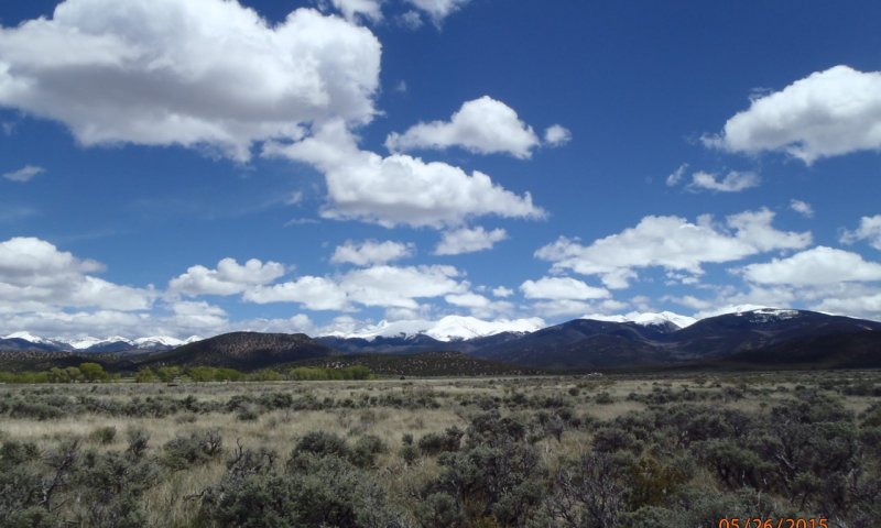
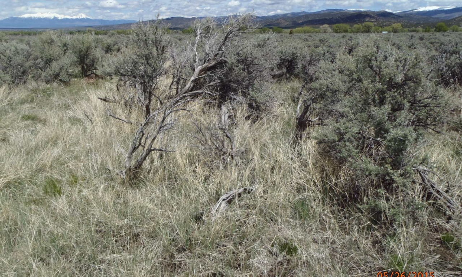
Figure 7. The reference state is grass dominant with shrubs sub-dominant.
The reference state has a mix of grasses, forbs, and shrubs. Grasses provide the most annual production with shrubs secondary. The state has a diversity of cool and warm season species such as western wheatgrass, blue grama, and needleandthread, with Wyoming big sagebrush scattered throughout.
Resilience management. The reference state is the most resilient to disturbance. A mix of grass and shrubs provide a diversity of root systems which maximized ecological processes such as decomposition, mineralization, and soil aggregation. This in turn maximizes water infiltration and protection from erosion.
Community 1.1
Grass and Shrub Mix

Figure 8. Reference: Grass-Shrub Mix
The potential vegetation is about 70% grasses and grass-like plants, 5% forbs, and 25% shrubs. The plant community is dominated by both cool and warm-season grasses, shrubs, and a scattering of forbs. The dominant grasses are western wheatgrass and blue grama. Sub-dominant grasses include galleta (NM), Indian ricegrass, needleandthread, bottlebrush squirreltail, sand dropseed, and threeawn. Significant forbs include scarlet globemallow, buckwheat species, primrose, penstemon, aster, lupine, and groundsel species. Big sagebrush is the dominant shrub, making up 15-25% of the total vegetative production. Other shrubs include Greene’s rabbitbrush, winterfat, fourwing saltbush, plains pricklypear, and small soapweed.
Resilience management. This plant community is well adapted to the San Luis Valley climatic conditions and is resilient to many disturbances. The diversity in plant species allows for high drought tolerance. Plant litter is properly distributed with very little movement off-site and natural plant mortality is low. This is a sustainable plant community in terms of soil stability, watershed function and biologic integrity.
Dominant plant species
-
Wyoming big sagebrush (Artemisia tridentata ssp. wyomingensis), shrub
-
western wheatgrass (Pascopyrum smithii), grass
-
blue grama (Bouteloua gracilis), grass
Figure 9. Annual production by plant type (representative values) or group (midpoint values)
Table 5. Annual production by plant type
| Plant type | Low (lb/acre) |
Representative value (lb/acre) |
High (lb/acre) |
|---|---|---|---|
| Grass/Grasslike | 420 | 630 | 840 |
| Shrub/Vine | 150 | 225 | 300 |
| Forb | 30 | 45 | 60 |
| Total | 600 | 900 | 1200 |
Figure 10. Plant community growth curve (percent production by month). CO5105, Warm/cool season co-dominant; MLRA-51; fine textured soils.
| Jan | Feb | Mar | Apr | May | Jun | Jul | Aug | Sep | Oct | Nov | Dec |
|---|---|---|---|---|---|---|---|---|---|---|---|
| J | F | M | A | M | J | J | A | S | O | N | D |
| 0 | 0 | 0 | 2 | 40 | 30 | 18 | 5 | 3 | 2 | 0 | 0 |
Community 1.2
Grass Dominant

Figure 11. Grass dominant following sagebrush treatment and three years of careful, managed grazing.
This community is dominated be grasses. Common plants include: western wheatgrass, blue grama, needleandtread, squirreltail, Indian ricegrass, and sand dropseed. The site is a result from the aftermath of shrub disturbance plus careful grazing management. Over time shrub species will increase.
Resilience management. This community is fairly resilient to some disturbance, especially fire, but less resistant to other disturbance such as drought or repetitive grazing of palatable species through critical growing periods with high utilization. .
Community 1.3
Sagebrush Dominant

Figure 12. This site has become dominant with sagebrush.
Big sagebrush and Greene’s rabbitbrush have significantly increased. Western wheatgrass, blue grama, fourwing saltbush, and winterfat have decreased in abundance, production, and vigor. Indian ricegrass and needleandthread have been reduced to remnant amounts. Sand dropseed, threeawn, and ring muhly have increased as well as snakeweed, rubber rabbitbrush, and annual forbs. Galleta has increased in the southern reaches of the MLRA (primarily in New Mexico).
Resilience management. Herbaceous plant frequency, vigor, and litter have decreased. Increased bare ground between shrubs is beginning to occur. Water cycle, nutrient cycle, and biotic integrity of the community are becoming impaired.
Pathway 1.1A
Community 1.1 to 1.2


A trigger event to decrease shrubs such as fire, mechanical, or chemical control. This coupled with grazing management that allows grasses to grow, flower, and seed most years.
Pathway 1.1B
Community 1.1 to 1.3


Over time, without fire to keep shrubs in check, coupled with grazing that continuously pressures palatable species such as western wheatgrass and needleandthread with repetitive, high utilization, the site becomes shrub dominant. Shrubs have a competitive advantage with natural grazing defenses and deep tap roots that can secure water and nutrients.
Pathway 1.2A
Community 1.2 to 1.1


Shrubs will increase over time due to a competitive advantage of deep tap roots and unpalatable forage.It will probably take longer than 10 years to get back to the reference community.
Pathway 1.2B
Community 1.2 to 1.3


Over time, without fire to set the shrubs back coupled with grazing that continuously pressures palatable species such as western wheat and needleandthread, the site becomes shrub dominant. Shrubs have a competitive advantage with natural grazing defenses and deep tap roots that can secure water and nutrients.
Pathway 1.3A
Community 1.3 to 1.1


Grazing management where grass cover improves over time may build enough fine fuel to carry fire and move the site back to a natural fire regime. The natural fire regime will help keep the shrubs in check and allow for a grass dominant mix. Plus grass growth eventually out-competes sagebrush germination.
Pathway 1.3B
Community 1.3 to 1.2


A trigger event to decrease shrubs such as fire, mechanical, or chemical control. This coupled with grazing management that allows grasses to grow, flower, and seed every year.
State 2
Degraded
Resilience management. This state has limited resilience to disturbance. Erosion is active with new gullies evident. Long-duration drought may affect and kill the sagebrush as well.
Community 2.1
Decadent Sagebrush
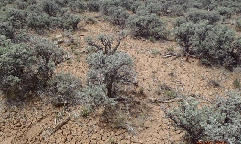
Figure 13. This site has crossed a threshold to a decadent state

Figure 14. Increased soil erosion on the decadent sagebrush state.
Big sagebrush dominates the plant community. Western wheatgrass and blue grama remain scattered and in low vigor. If blue grama is present, it frequently appears low in stature in shallow rooted patches. As the site continues to lose herbaceous species due to multiple feedbacks, bare ground increases and a surface soil crust develops. This soil surface condition retards water infiltration and grass establishment/recruitment and allows the site to persist in a big sagebrush state. Production, species composition, and diversity are drastically reduced. Water cycle, nutrient cycle, and biotic integrity have been severely affected. As litter amounts decrease, bare areas increase. The semiarid environment coupled with loss of cover, magnifies soil surface crusting which impairs water infiltration subsequently increasing overland flow. In advanced stages of non-activity, big sagebrush will show signs of decadence and mortality.
State 3
Degraded Bare Ground
Resilience management. Water and wind erosion is a very large concern in this state.
Community 3.1
Bare Ground, Snakeweed, Rabbitbrush, and Annuals
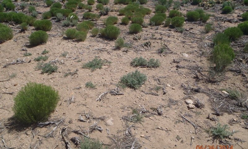
Figure 15. Sagebrush treatment, re-seeding followed by grazing
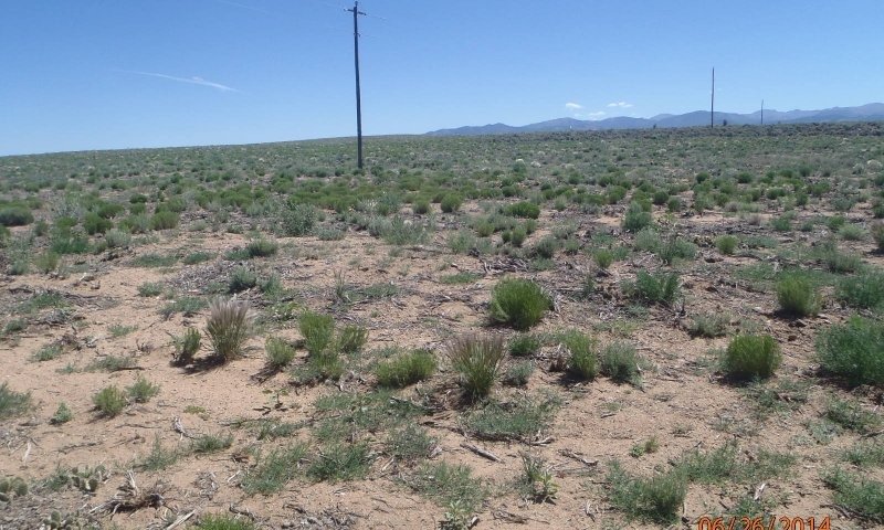
Figure 16. Sagebrush treatment, re-seeding followed by grazing
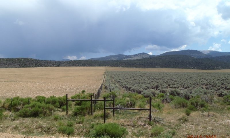
Figure 17. Wholesale mowing of sagebrush canopy
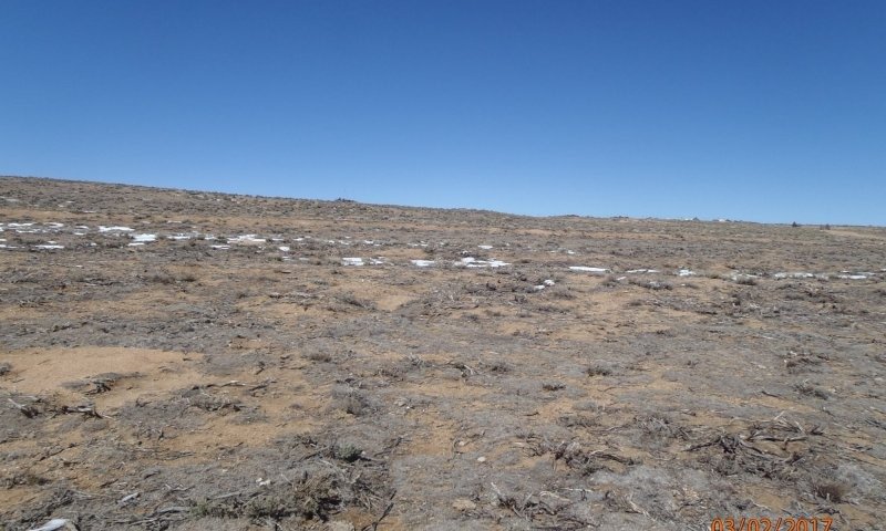
Figure 18. Four years following wholesale mowing of sagebrush
This community consists of mostly bare ground with some rabbitbrush, snakeweed, and annuals. Some blue grama may exist in patches along with Colorado rubberweed, and ring muhly.
Transition T1A
State 1 to 2
The major long-term driver is repetitive, high utilization grazing of grass species while not allowing for regrowth and recovery for multiple years. This type of management eventually decreases health and vigor of grasses, fine fuel and the site's ability to carry fire. Big sagebrush gains a competitive advantage due to deep root systems and natural grazing defenses. Eventually the bare soil forms a crust due to low aggregate stability and a high percentage of bare ground. This makes it difficult for recruits to germinate.
Transition T1B
State 1 to 3
The major long-term driver is repetitive defoliation with high utilization during the growing season allowing for no rest and recovery of palatable species, causing death of grass and forb species. This in turn causes greater soil loss and erosion on the site. This coupled with a wholesale mechanical treatment of shrubs will denude the site and create feedback loops where ecological processes are poorly functioning. .
Restoration pathway R2A
State 2 to 1
Short-term sagebrush treatment, coupled with range seeding, and a period of grazing rest for stand establishment. Shrub removal should not be wholesale but in a mosaic of patchiness as sagebrush is an important species for the health of the site. It is also best to implement long-term grazing management strategies where indicator plant species are seldom defoliated during the critical growth period and have an opportunity to colonize and restore ecosystem health.
Transition T2A
State 2 to 3
A brush control event followed by repetitive defoliation at high utilization rates without rest or recovery, thereby inhibiting the germination of new plant species. New seedlings will not be allowed to germinate, produce roots and shoots and colonize the area. Drought following treatment will exacerbate the feedbacks which lead toward degredation.
Restoration pathway R3A
State 3 to 1
The plants, soil, and microbial community needs to be re-established. This will be a long-term, expensive endeavor.
Transition T3A
State 3 to 2
Over a long period of time big sagebrush will begin to recolonize the site.
Additional community tables
Table 6. Community 1.1 plant community composition
| Group | Common name | Symbol | Scientific name | Annual production (lb/acre) | Foliar cover (%) | |
|---|---|---|---|---|---|---|
|
Grass/Grasslike
|
||||||
| 1 | 480–680 | |||||
| western wheatgrass | PASM | Pascopyrum smithii | 180–300 | – | ||
| blue grama | BOGR2 | Bouteloua gracilis | 120–250 | – | ||
| needle and thread | HECOC8 | Hesperostipa comata ssp. comata | 45–150 | – | ||
| Indian ricegrass | ACHY | Achnatherum hymenoides | 15–65 | – | ||
| squirreltail | ELELE | Elymus elymoides ssp. elymoides | 15–65 | – | ||
| sand dropseed | SPCR | Sporobolus cryptandrus | 0–65 | – | ||
| threeawn | ARIST | Aristida | 0–24 | – | ||
| Grass, perennial | 2GP | Grass, perennial | 0–24 | – | ||
| sedge | CAREX | Carex | 0–8 | – | ||
| James' galleta | PLJA | Pleuraphis jamesii | 0–8 | – | ||
|
Forb
|
||||||
| 2 | 40–80 | |||||
| Forb, perennial | 2FP | Forb, perennial | 8–50 | – | ||
| scarlet globemallow | SPCO | Sphaeralcea coccinea | 16–48 | – | ||
| sulphur-flower buckwheat | ERUM | Eriogonum umbellatum | 8–24 | – | ||
| crownleaf evening primrose | OECO2 | Oenothera coronopifolia | 0–16 | – | ||
| white locoweed | OXSE | Oxytropis sericea | 0–16 | – | ||
| beardtongue | PENST | Penstemon | 0–16 | – | ||
| woolly plantain | PLPA2 | Plantago patagonica | 0–16 | – | ||
| ragwort | SENEC | Senecio | 0–16 | – | ||
| locoweed | OXYTR | Oxytropis | 0–8 | – | ||
| lupine | LUPIN | Lupinus | 0–8 | – | ||
| aster | ASTER | Aster | 0–8 | – | ||
| milkvetch | ASTRA | Astragalus | 0–8 | – | ||
|
Shrub/Vine
|
||||||
| 3 | 160–300 | |||||
| Wyoming big sagebrush | ARTRW8 | Artemisia tridentata ssp. wyomingensis | 120–250 | – | ||
| Shrub (>.5m) | 2SHRUB | Shrub (>.5m) | 0–75 | – | ||
| fourwing saltbush | ATCA2 | Atriplex canescens | 5–40 | – | ||
| Greene's rabbitbrush | CHGR6 | Chrysothamnus greenei | 5–40 | – | ||
| prairie sagewort | ARFR4 | Artemisia frigida | 5–40 | – | ||
| rubber rabbitbrush | ERNAN5 | Ericameria nauseosa ssp. nauseosa var. nauseosa | 0–24 | – | ||
| winterfat | KRLA2 | Krascheninnikovia lanata | 0–24 | – | ||
| plains pricklypear | OPPO | Opuntia polyacantha | 0–16 | – | ||
| soapweed yucca | YUGL | Yucca glauca | 0–16 | – | ||
| broom snakeweed | GUSA2 | Gutierrezia sarothrae | 0–16 | – | ||
Interpretations
Animal community
The following table lists suggested initial stocking rates for cattle under continuous grazing (year long grazing or growing season long grazing) under normal growing conditions however, continuous grazing is not recommended. These are conservative estimates that should be used only as guidelines in the initial stages of the conservation planning process. Often, the current plant composition does not entirely match any particular plant community (described in this ecological site description). Because of this, a field visit is recommended, in all cases, to document plant composition and production. More precise carrying capacity estimates should eventually be calculated using on-site information along with animal preference data, particularly when grazers other than cattle are involved. Under more intensive grazing management, improved harvest efficiencies can result in an increased carrying capacity.
Plant Community/ Production (lbs./acre)/ Stocking Rate (AUM/acre)
Reference: Grass-Shrub Mix / 800/ 0.26
Grass Dominant/ 900/ 0.29
Sagebrush Dominant / 500/ 0.16
Degraded: Decadent Big Sagebrush / 250/ 0.08
Degraded: Bare Ground, Snakeweed, Rabbitbrush, Annuals/ 200/ 0.06
Grazing by domestic livestock is one of the major income-producing industries in the area. Rangelands in this area provide yearlong forage under prescribed grazing for cattle, sheep, horses and other herbivores. During the dormant period, livestock may need supplementation based on reliable forage analysis.
Hydrological functions
Water is the principal factor limiting herbage production on this site. The site is dominated by soils in hydrologic group D. Infiltration varies from moderate to slow and runoff potential varies from medium to high depending on soil hydrologic group and ground cover. In many cases, areas with greater than 75% ground cover have the greatest potential for high infiltration and lower runoff. An exception would be where short grasses form a dense sod and dominate the site. Areas where ground cover is less than 50% have the greatest potential to have reduced infiltration and higher runoff (refer to Section 4, NRCS National Engineering Handbook for runoff quantities and hydrologic curves).
Supporting information
Inventory data references
Information presented here has been derived from NRCS clipping data, numerous ocular estimates and other inventory data. Field observations from experienced range trained personnel were used extensively to develop this ecological site description. Specific data information is contained in individual landowner/user case files and other files located in county NRCS field offices.
Location of Typical Example of Site:
Along Highway 159 between Fort Garland and San Luis in Costilla County.
Field Offices in Colorado where the site occurs:
Alamosa, Center, and San Luis
References
-
. 2021 (Date accessed). USDA PLANTS Database. http://plants.usda.gov.
Other references
Chapman, S.S., G.E. Griffith, J.M. Omernik, A.B. Price, J. Freeouf, and D.L. Schrupp. 2006. Ecoregions of Colorado. (2-sided color posterwith map, descriptive text, summary tables, and photographs). U.S. Geological Survey, Reston, VA. Scale 1:1,200,000.
Cleland, D.T.; Freeouf, J.A.; Keys, J.E.; Nowacki, G.J.; Carpenter, C.A.; and McNab, W.H. 2007. Ecological Subregions: Sections andSubsections for the conterminous United States. Gen. Tech. Report WO-76D [Map on CD-ROM] (A.M. Sloan, cartographer). Washington,DC: U.S. Department of Agriculture, Forest Service, presentation scale 1:3,500,000; colored.
Soil Conservation Service (SCS). August 1975. Range Site Description for Valley Bench #278. : USDA, Denver Colorado.
United States Department of Agriculture, Natural Resources Conservation Service. 2006. Land Resource Regions and Major Land Resource Areas of the United States, the Caribbean, and the Pacific Basin. U.S. Department of Agriculture Handbook 296.
USDA, NRCS. National Range and Pasture Handbook, September 1997
USDA, NRCS. National Soil Information System, Information Technology Center, 2150 Centre Avenue, Building A, Fort Collins, CO 80526. (http://nasis.nrcs.usda.gov)
Western Regional Climate Center, 2215 Raggio Parkway, Reno, Nevada 89512 (http://www.wrcc.dri.edu/index.html)
Contributors
Herman Garcia, Dick Sparks, Cynthia Villa, Scott Woodall, Alan Steube,
Terri Skadeland, Ted Lucero, Charles Hibner
Suzanne Mayne-Kinney
Approval
Kirt Walstad, 5/12/2025
Acknowledgments
Project Staff:
Suzanne Mayne-Kinney, Ecological Site Specialist, NRCS MLRA, Grand Junction SSO
Alan Stuebe, MLRA Soil Survey Leader, NRCS MLRA Alamosa SSO
Program Support:
Rachel Murph, NRCS CO State Rangeland Management Specialist, Denver
Eva Muller, Regional Director, Rocky Mountain Regional Soil Survey Office, Bozeman, MT
B.J. Shoup, CO State Soil Scientist, Denver
Eugene Backhaus, CO State Resource Conservationist, Denver
--Site Development and Testing Plan--:
Future work to validate and further refine the information in this Provisional Ecological Site Description is necessary. This will include field activities to collect low-, medium-, and high-intensity sampling, soil correlations, and analysis of that data.
Additional information and data are required to refine the Plant Production and Annual Production tables for this ecological site. The extent of MLRA 51 must be further investigated.
Field testing of the information contained in this Provisional ESD is required. As this ESD is moved to the Approved ESD level, reviews from the technical team, quality control, quality assurance, and peers will be conducted.
Rangeland health reference sheet
Interpreting Indicators of Rangeland Health is a qualitative assessment protocol used to determine ecosystem condition based on benchmark characteristics described in the Reference Sheet. A suite of 17 (or more) indicators are typically considered in an assessment. The ecological site(s) representative of an assessment location must be known prior to applying the protocol and must be verified based on soils and climate. Current plant community cannot be used to identify the ecological site.
| Author(s)/participant(s) | C. Villa, H. Garcia, T. Lucero |
|---|---|
| Contact for lead author | |
| Date | 12/14/2004 |
| Approved by | Kirt Walstad |
| Approval date | |
| Composition (Indicators 10 and 12) based on | Annual Production |
Indicators
-
Number and extent of rills:
None to slight. If present, very short and apparent following intense rainfall events, on steeper slopes. -
Presence of water flow patterns:
None, except following high intensity storms. Flow paths if present will be short (1-3 feet), with minimal evidence of past or current soil deposition. Evidence of debris dams possible. -
Number and height of erosional pedestals or terracettes:
None to slight. Terracettes/pedestals may occur in or near edges of flow paths. More obvious following intense storms, especially on steeper slopes. -
Bare ground from Ecological Site Description or other studies (rock, litter, lichen, moss, plant canopy are not bare ground):
10-15% bare ground, with bare patches averaging 3-6 inches in diameter. Extended drought can cause bare ground to increase up to 20% with bare patches averaging 6-12 inches in diameter and may become interconnected. -
Number of gullies and erosion associated with gullies:
None -
Extent of wind scoured, blowouts and/or depositional areas:
None -
Amount of litter movement (describe size and distance expected to travel):
Litter movement is minimal and short. -
Soil surface (top few mm) resistance to erosion (stability values are averages - most sites will show a range of values):
Stability class rating anticipated to be 4-5 in interspaces at soil surface. -
Soil surface structure and SOM content (include type of structure and A-horizon color and thickness):
Soils are deep and well drained. Surface soils range from fine sandy loam, sandy loam to loam. The A-horizon is yellowish brown to dark yellowish brown that can extend to up 9 inches in depth. The structure is typically weak fine granular. -
Effect of community phase composition (relative proportion of different functional groups) and spatial distribution on infiltration and runoff:
The composition and distribution of rhizomatous grass, bunchgrasses and shrubs tends to slow overland flow and moderate runoff. Diverse canopy structure reduces raindrop impact allowing for increased time for infiltration. Extended drought reduces grass and forb production causing decreased infiltration and increased runoff following intense storms. -
Presence and thickness of compaction layer (usually none; describe soil profile features which may be mistaken for compaction on this site):
None -
Functional/Structural Groups (list in order of descending dominance by above-ground annual-production or live foliar cover using symbols: >>, >, = to indicate much greater than, greater than, and equal to):
Dominant:
cool season rhizomatous grass = shrubs >Sub-dominant:
cool season bunchgrass > warm season bunchgrass >Other:
forbsAdditional:
-
Amount of plant mortality and decadence (include which functional groups are expected to show mortality or decadence):
Minimum. Expect some natural mortality and decadence on bunchgrasses and shrubs. Extended drought will cause mortality and decadence to increase. -
Average percent litter cover (%) and depth ( in):
15-25% litter cover at 0.25 inch depth. Litter cover during and following extended drought ranges from 10-15%. -
Expected annual annual-production (this is TOTAL above-ground annual-production, not just forage annual-production):
600 lbs./ac. low precip years; 900 lbs./ac. average precip years; 1200 lbs./ac. above average precip years. After extended drought, production can be reduced by 300 – 600 lbs./ac. or more. -
Potential invasive (including noxious) species (native and non-native). List species which BOTH characterize degraded states and have the potential to become a dominant or co-dominant species on the ecological site if their future establishment and growth is not actively controlled by management interventions. Species that become dominant for only one to several years (e.g., short-term response to drought or wildfire) are not invasive plants. Note that unlike other indicators, we are describing what is NOT expected in the reference state for the ecological site:
Greene’s rabbitbrush, pricklypear cactus, broom snakeweed, big sagebrush -
Perennial plant reproductive capability:
The only limitations are weather-related, natural disease, inter-species competition, wildlife, and insects that may temporarily reduce reproductive capability.
Print Options
Sections
Font
Other
The Ecosystem Dynamics Interpretive Tool is an information system framework developed by the USDA-ARS Jornada Experimental Range, USDA Natural Resources Conservation Service, and New Mexico State University.
Click on box and path labels to scroll to the respective text.