Major Land Resource Area 064X
Mixed Sandy and Silty Tableland and Badlands
Accessed: 04/10/2026
Next steps
-
1
Select an ecological site
Select an ecological site using the list, keys, photos, briefcase, or quick search option located on this page. -
2
Explore the ecological site description
Next, learn more about the selected ecological site and its characteristic dynamics by browsing the ecological site description and exploring alternative state and transition model formats.
Ecological site list
-
i
Key Characteristics
- NORMAL LANDSCAPE POSITIONS in Both Precipitation zones (Upland, slopes normally linear, 1-6 percent except Sandy, Sands, and Gravelly sites which can have complex slopes, Back slope, Summit, Foot slope).
- Dig hole to 20 inches. Is there a claypan within 16 inches of the surface?
- No. Determine surface and subsoil texture?
- Loam, Silt loam, Silty, Clay loam, Sandy clay loam, Very fine sandy loam? (0.5 – 1.75” ribbon)?
- Yes. Is the site an old stream terrace?
- No. Determine Precipitation Zone:
- Loamy 14-17" PZ
-
i
Key Characteristics
- NORMAL LANDSCAPE POSITIONS in Both Precipitation zones (Upland, slopes normally linear, 1-6 percent except Sandy, Sands, and Gravelly sites which can have complex slopes, Back slope, Summit, Foot slope).
- Dig hole to 20 inches. Is there a claypan within 16 inches of the surface?
- No. Determine surface and subsoil texture?
- Loam, Silt loam, Silty, Clay loam, Sandy clay loam, Very fine sandy loam? (0.5 – 1.75” ribbon)?
- Yes. Is the site an old stream terrace?
- Yes. Is the site in the Badlands?
- No. Loamy Terrace (R064XY028NE).
-
i
Key Characteristics
- NORMAL LANDSCAPE POSITIONS in Both Precipitation zones (Upland, slopes normally linear, 1-6 percent except Sandy, Sands, and Gravelly sites which can have complex slopes, Back slope, Summit, Foot slope).
- Dig hole to 20 inches. Is there a claypan within 16 inches of the surface?
- No. Determine surface and subsoil texture?
- Loam, Silt loam, Silty, Clay loam, Sandy clay loam, Very fine sandy loam? (0.5 – 1.75” ribbon)?
- Yes. Is the site an old stream terrace?
- No. Determine Precipitation Zone:
- Loamy 17-20" PZ
-
i
Key Characteristics
- RUN-IN LANDSCAPE POSITIONS (Bottomlands, Drainageways, Interdunes, etc., not depressions, Toe slope).
- Observe the soil to a depth of 60 inches. Is there evidence of a permanent water table within 1-2 feet of the surface and the site is dominated by hydrophytes?
- Yes. Is the site very sandy?
- Yes. Wet Subirrigated (R064XY002NE).
-
i
Key Characteristics
- NORMAL LANDSCAPE POSITIONS in Both Precipitation zones (Upland, slopes normally linear, 1-6 percent except Sandy, Sands, and Gravelly sites which can have complex slopes, Back slope, Summit, Foot slope).
- Dig hole to 20 inches. Is there a claypan within 16 inches of the surface?
- No. Determine surface and subsoil texture?
- Sandy loam, Fine sandy loam, Loamy very fine sand (0.25-0.5” ribbon)?
- Yes. Is the site a low stream terrace?
- No. Is the site in an interdune landscape?
- No. Determine Precipitation Zone:
- Sandy 14-17" PZ (R064XY011NE)
-
i
Key Characteristics
- NORMAL LANDSCAPE POSITIONS in Both Precipitation zones (Upland, slopes normally linear, 1-6 percent except Sandy, Sands, and Gravelly sites which can have complex slopes, Back slope, Summit, Foot slope).
- Dig hole to 20 inches. Is there a claypan within 16 inches of the surface?
- No. Determine surface and subsoil texture?
- Sand, Loamy sand, Loamy fine sand (no ribbon)?
- Yes. Sands (R064XY012NE).
-
i
Key Characteristics
- NORMAL LANDSCAPE POSITIONS in Both Precipitation zones (Upland, slopes normally linear, 1-6 percent except Sandy, Sands, and Gravelly sites which can have complex slopes, Back slope, Summit, Foot slope).
- Dig hole to 20 inches. Is there a claypan within 16 inches of the surface?
- No. Determine surface and subsoil texture?
- Clay or Silty Clay (40 to 55% clay) Surface (1.75 – 3.0” ribbon) with Clayey Subsoil?
- Yes. Determine Precipitation Zone:
- Clayey 14-17" PZ
-
i
Key Characteristics
- RUN-IN LANDSCAPE POSITIONS (Bottomlands, Drainageways, Interdunes, etc., not depressions, Toe slope).
- Observe the soil to a depth of 60 inches. Is there evidence of a permanent water table within 1-2 feet of the surface and the site is dominated by hydrophytes?
- Yes. Is the site very sandy?
- No. Wet Land (R064XY022NE).
-
i
Key Characteristics
- RUN-IN LANDSCAPE POSITIONS (Bottomlands, Drainageways, Interdunes, etc., not depressions, Toe slope).
- Observe the soil to a depth of 60 inches. Is there evidence of a permanent water table within 1-2 feet of the surface and the site is dominated by hydrophytes?
- Is there evidence of a permanent water table within 2 to 5 feet of the surface?
- Yes. Does the soil have visible salt crystals within 6 inches?
- No. Subirrigated (R064XY024NE).
-
i
Key Characteristics
- RUN-IN LANDSCAPE POSITIONS (Bottomlands, Drainageways, Interdunes, etc., not depressions, Toe slope).
- Observe the soil to a depth of 60 inches. Is there evidence of a permanent water table within 1-2 feet of the surface and the site is dominated by hydrophytes?
- Is there evidence of a permanent water table within 2 to 5 feet of the surface?
- Yes. Does the soil have visible salt crystals within 6 inches?
- Yes. Saline Subirrigated (R064XY025NE).
-
i
Key Characteristics
- RUN-IN LANDSCAPE POSITIONS (Bottomlands, Drainageways, Interdunes, etc., not depressions, Toe slope).
- Observe the soil to a depth of 60 inches. Is there evidence of a permanent water table within 1-2 feet of the surface and the site is dominated by hydrophytes?
- Is there evidence of a permanent water table within 2 to 5 feet of the surface?
- No. Does water flow into and over/through the site?
- Yes. Are there visible salts within 16 inches of the surface and permanently moist soil at 4 to 5 feet?
- No. Is the area in “Badlands”?
- No. Does the site occasionally flood and have a clayey or silty clay surface texture?
- No. Does the site occasionally flood and have a Loam, Silt loam, Silty, Clay loam, Sandy clay loam, or Very fine sandy loam surface texture?
- Yes. Loamy Overflow (R064XY026NE).
-
i
Key Characteristics
- RUN-IN LANDSCAPE POSITIONS (Bottomlands, Drainageways, Interdunes, etc., not depressions, Toe slope).
- Observe the soil to a depth of 60 inches. Is there evidence of a permanent water table within 1-2 feet of the surface and the site is dominated by hydrophytes?
- Is there evidence of a permanent water table within 2 to 5 feet of the surface?
- No. Does water flow into and over/through the site?
- Yes. Are there visible salts within 16 inches of the surface and permanently moist soil at 4 to 5 feet?
- No. Is the area in “Badlands”?
- No. Does the site occasionally flood and have a clayey or silty clay surface texture?
- Yes. Clayey Overflow (R064XY027NE).
-
i
Key Characteristics
- NORMAL LANDSCAPE POSITIONS in Both Precipitation zones (Upland, slopes normally linear, 1-6 percent except Sandy, Sands, and Gravelly sites which can have complex slopes, Back slope, Summit, Foot slope).
- Dig hole to 20 inches. Is there a claypan within 16 inches of the surface?
- No. Determine surface and subsoil texture?
- Sandy loam, Fine sandy loam, Loamy very fine sand (0.25-0.5” ribbon)?
- Yes. Is the site a low stream terrace?
- Yes. Sandy Lowland (R064XY029NE).
-
i
Key Characteristics
- RUN-IN LANDSCAPE POSITIONS (Bottomlands, Drainageways, Interdunes, etc., not depressions, Toe slope).
- Observe the soil to a depth of 60 inches. Is there evidence of a permanent water table within 1-2 feet of the surface and the site is dominated by hydrophytes?
- Is there evidence of a permanent water table within 2 to 5 feet of the surface?
- No. Does water flow into and over/through the site?
- Yes. Are there visible salts within 16 inches of the surface and permanently moist soil at 4 to 5 feet?
- Yes. Saline Lowland (R064XY030NE).
-
i
Key Characteristics
- NORMAL LANDSCAPE POSITIONS in Both Precipitation zones (Upland, slopes normally linear, 1-6 percent except Sandy, Sands, and Gravelly sites which can have complex slopes, Back slope, Summit, Foot slope).
- Dig hole to 20 inches. Is there a claypan within 16 inches of the surface?
- No. Determine surface and subsoil texture?
- Sandy loam, Fine sandy loam, Loamy very fine sand (0.25-0.5” ribbon)?
- Yes. Is the site a low stream terrace?
- No. Is the site in an interdune landscape?
- No. Determine Precipitation Zone:
- Sandy 17-20" PZ (R064XY032NE).
-
i
Key Characteristics
- NORMAL LANDSCAPE POSITIONS in Both Precipitation zones (Upland, slopes normally linear, 1-6 percent except Sandy, Sands, and Gravelly sites which can have complex slopes, Back slope, Summit, Foot slope).
- Dig hole to 20 inches. Is there a claypan within 16 inches of the surface?
- No. Determine surface and subsoil texture?
- Clay or Silty Clay (40 to 55% clay) Surface (1.75 – 3.0” ribbon) with Clayey Subsoil?
- Yes. Determine Precipitation Zone:
- Clayey 17-20" PZ
-
i
Key Characteristics
- RUN-OFF LANDSCAPE POSITIONS (Upland, normally convex short slopes > 6 percent, Shoulder).
- Is the site on a steep slope, escarpment, river break or slump area (25-60% slope), with exposed bedrock at or near the surface, and soils generally calcareous and of various depths? Deciduous trees and shrub are almost always present on this site.
- No. Dig hole to a depth of 20 inches minimum. Is there root restrictive layer within 10 inches of the soil surface?
- No. Is there a root restricting layer within 10-20 inches of the surface?
- No. Is the soil > 20 inches in depth with a thin surface layer (< 3” ) and effervesce at or near the surface (within 6” )?
- Yes. Thin Upland (R064XY037NE).
-
i
Key Characteristics
- RUN-OFF LANDSCAPE POSITIONS (Upland, normally convex short slopes > 6 percent, Shoulder).
- Is the site on a steep slope, escarpment, river break or slump area (25-60% slope), with exposed bedrock at or near the surface, and soils generally calcareous and of various depths? Deciduous trees and shrub are almost always present on this site.
- No. Dig hole to a depth of 20 inches minimum. Is there root restrictive layer within 10 inches of the soil surface?
- No. Is there a root restricting layer within 10-20 inches of the surface?
- Yes. Is the soil derived from shale, mudstone, or siltstone, with weathered parachannery fragments between the A and Cr horizon, and the soil is calcareous? The surface texture is Clayey (2-3” ribbon)?
- Yes. Shallow Clayey (R064XY039NE).
-
i
Key Characteristics
- RUN-OFF LANDSCAPE POSITIONS (Upland, normally convex short slopes > 6 percent, Shoulder).
- Is the site on a steep slope, escarpment, river break or slump area (25-60% slope), with exposed bedrock at or near the surface, and soils generally calcareous and of various depths? Deciduous trees and shrub are almost always present on this site.
- No. Dig hole to a depth of 20 inches minimum. Is there root restrictive layer within 10 inches of the soil surface?
- No. Is there a root restricting layer within 10-20 inches of the surface?
- Yes. Is the soil derived from shale, mudstone, or siltstone, with weathered parachannery fragments between the A and Cr horizon, and the soil is calcareous? The surface texture is Clayey (2-3” ribbon)?
- No. Is the soil 10 to 20 inches thick with a Clay loam, Silty clay loam, Sandy clay loam, or Silty surface texture (1-1.5” ribbon)? or a Sandy loam or Loamy sand surface texture (0.25-0.5” ribbon)?
- Yes.
- Shallow (R064XY040NE)
-
i
Key Characteristics
- OTHER LANDSCAPE POSITIONS (Basin, Depression, Normal, Run-off and/or Run-in, All Hillslope Positions except Shoulder).
- Dig a hole to 20 inches. Does the soil have a claypan within 16 inches?
- Yes. Is it in a closed depression?
- No. Is the claypan within 4 inches of the surface?
- No. Claypan is deeper than 4 inches - Claypan (R064XY044NE).
-
i
Key Characteristics
- NORMAL LANDSCAPE POSITIONS in Both Precipitation zones (Upland, slopes normally linear, 1-6 percent except Sandy, Sands, and Gravelly sites which can have complex slopes, Back slope, Summit, Foot slope).
- Dig hole to 20 inches. Is there a claypan within 16 inches of the surface?
- No. Determine surface and subsoil texture?
- Clay or Silty Clay (> 55% clay). ( > 3.0” ribbon)? Bare ground will be common.
- Yes. Dense Clay (R064XY045NE).
-
i
Key Characteristics
- OTHER LANDSCAPE POSITIONS (Basin, Depression, Normal, Run-off and/or Run-in, All Hillslope Positions except Shoulder).
- Dig a hole to 20 inches. Does the soil have a claypan within 16 inches?
- Yes. Is it in a closed depression?
- No. Is the claypan within 4 inches of the surface?
- Yes. Thin Claypan (R064XY046NE).
-
i
Key Characteristics
- RUN-OFF LANDSCAPE POSITIONS (Upland, normally convex short slopes > 6 percent, Shoulder).
- Is the site on a steep slope, escarpment, river break or slump area (25-60% slope), with exposed bedrock at or near the surface, and soils generally calcareous and of various depths? Deciduous trees and shrub are almost always present on this site.
- No. Dig hole to a depth of 20 inches minimum. Is there root restrictive layer within 10 inches of the soil surface?
- Yes.
- Very Shallow (R064XY047NE)
-
i
Key Characteristics
- NORMAL LANDSCAPE POSITIONS in Both Precipitation zones (Upland, slopes normally linear, 1-6 percent except Sandy, Sands, and Gravelly sites which can have complex slopes, Back slope, Summit, Foot slope).
- Dig hole to 20 inches. Is there a claypan within 16 inches of the surface?
- No. Determine surface and subsoil texture?
- Loam, Silt loam, Silty, Clay loam, Sandy clay loam, Very fine sandy loam? (0.5 – 1.75” ribbon)?
- Yes. Is the site an old stream terrace?
- Yes. Is the site in the Badlands?
- Yes. Badlands Terrace (R064XY048NE).
-
i
Key Characteristics
- RUN-IN LANDSCAPE POSITIONS (Bottomlands, Drainageways, Interdunes, etc., not depressions, Toe slope).
- Observe the soil to a depth of 60 inches. Is there evidence of a permanent water table within 1-2 feet of the surface and the site is dominated by hydrophytes?
- Is there evidence of a permanent water table within 2 to 5 feet of the surface?
- No. Does water flow into and over/through the site?
- Yes. Are there visible salts within 16 inches of the surface and permanently moist soil at 4 to 5 feet?
- No. Is the area in “Badlands”?
- Yes. Badlands Overflow (R064XY049NE).
-
i
Key Characteristics
- RUN-OFF LANDSCAPE POSITIONS (Upland, normally convex short slopes > 6 percent, Shoulder).
- Is the site on a steep slope, escarpment, river break or slump area (25-60% slope), with exposed bedrock at or near the surface, and soils generally calcareous and of various depths? Deciduous trees and shrub are almost always present on this site.
- Yes. Thin Breaks (R064XY050NE) This site is a landscape feature not necessarily correlated to individual soil components.
-
i
Key Characteristics
- OTHER LANDSCAPE POSITIONS (Basin, Depression, Normal, Run-off and/or Run-in, All Hillslope Positions except Shoulder).
- Dig a hole to 20 inches. Does the soil have a claypan within 16 inches?
- Yes. Is it in a closed depression?
- Yes. Closed Depression (R064XY065NE).
- OTHER LANDSCAPE POSITIONS (Basin, Depression, Normal, Run-off and/or Run-in, All Hillslope Positions except Shoulder).
- Dig a hole to 20 inches. Does the soil have a claypan within 16 inches?
- No. Is the area in a basin or closed depression with no outlet?
- Yes. Does the site pond water briefly after snowmelt or heavy rain or during abnormally wet years?
- Yes. Closed Depression (R064XY065NE).
-
i
Key Characteristics
- NORMAL LANDSCAPE POSITIONS in Both Precipitation zones (Upland, slopes normally linear, 1-6 percent except Sandy, Sands, and Gravelly sites which can have complex slopes, Back slope, Summit, Foot slope).
- Dig hole to 20 inches. Is there a claypan within 16 inches of the surface?
- No. Skeletal soil with up to 60% coarse gravel, pebbles, cobbles, stone?
- Yes. Gravelly HU (R064XY112WY). Only found in Hartville Uplift (HU) Area of Wyo.
-
i
Key Characteristics
- RUN-OFF LANDSCAPE POSITIONS (Upland, normally convex short slopes > 6 percent, Shoulder).
- Is the site on a steep slope, escarpment, river break or slump area (25-60% slope), with exposed bedrock at or near the surface, and soils generally calcareous and of various depths? Deciduous trees and shrub are almost always present on this site.
- No. Dig hole to a depth of 20 inches minimum. Is there root restrictive layer within 10 inches of the soil surface?
- No. Is there a root restricting layer within 10-20 inches of the surface?
- Yes. Is the soil derived from shale, mudstone, or siltstone, with weathered parachannery fragments between the A and Cr horizon, and the soil is calcareous? The surface texture is Clayey (2-3” ribbon)?
- No. Is the soil 10 to 20 inches thick with a Clay loam, Silty clay loam, Sandy clay loam, or Silty surface texture (1-1.5” ribbon)? or a Sandy loam or Loamy sand surface texture (0.25-0.5” ribbon)?
- Yes.
- GX064X01X161 – Shallow Hartville Uplift, Wyo.
-
i
Key Characteristics
- RUN-OFF LANDSCAPE POSITIONS (Upland, normally convex short slopes > 6 percent, Shoulder).
- Is the site on a steep slope, escarpment, river break or slump area (25-60% slope), with exposed bedrock at or near the surface, and soils generally calcareous and of various depths? Deciduous trees and shrub are almost always present on this site.
- No. Dig hole to a depth of 20 inches minimum. Is there root restrictive layer within 10 inches of the soil surface?
- Yes.
- Very Shallow HU (R064XY176WY) Hartville Uplift, Wyo.
-
Ecological site map
Basemap
Find me
Find point
Full screen
Zoom in to display soil survey map units for an area of interest, and zoom out to display MLRAs. Select a map unit polygon to view ecological sites correlated to that map unit. View a brief description of an ecological site by clicking on its name in the map popup. Soil survey correlations may not be accurate, and ecological site classification of a location should always be verified in the field. Each selection may require the transfer of several hundred KB of data.
Ecological site keys
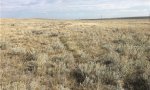
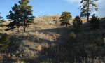
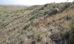
Ecological site photos
Print Options
Sections
Font
Other
Briefcase
Add ecological sites and Major Land Resource Areas to your briefcase by clicking on the briefcase (![]() ) icon wherever it occurs. Drag and drop items to reorder. Cookies are used to store briefcase items between browsing sessions. Because of this, the number of items that can be added to your briefcase is limited, and briefcase items added on one device and browser cannot be accessed from another device or browser. Users who do not wish to place cookies on their devices should not use the briefcase tool. Briefcase cookies serve no other purpose than described here and are deleted whenever browsing history is cleared.
) icon wherever it occurs. Drag and drop items to reorder. Cookies are used to store briefcase items between browsing sessions. Because of this, the number of items that can be added to your briefcase is limited, and briefcase items added on one device and browser cannot be accessed from another device or browser. Users who do not wish to place cookies on their devices should not use the briefcase tool. Briefcase cookies serve no other purpose than described here and are deleted whenever browsing history is cleared.
Ecological sites
Major Land Resource Areas
The Ecosystem Dynamics Interpretive Tool is an information system framework developed by the USDA-ARS Jornada Experimental Range, USDA Natural Resources Conservation Service, and New Mexico State University.