Natural Resources
Conservation Service
Ecological site R065XY012NE
Sands 14-17" PZ
Last updated: 2/04/2025
Accessed: 04/10/2026
General information
Provisional. A provisional ecological site description has undergone quality control and quality assurance review. It contains a working state and transition model and enough information to identify the ecological site.
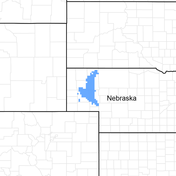
Figure 1. Mapped extent
Areas shown in blue indicate the maximum mapped extent of this ecological site. Other ecological sites likely occur within the highlighted areas. It is also possible for this ecological site to occur outside of highlighted areas if detailed soil survey has not been completed or recently updated.
MLRA notes
Major Land Resource Area (MLRA): 065X–Nebraska Sand Hills
The Nebraska Sand Hills (MLRA 65) is located in Nebraska (98 percent) and South Dakota (2 percent) and encompasses approximately 13.2 million acres (534,201 hectares) or 20,625 square miles (53,420 square kilometers). The largest town in the MLRA is North Platte, Nebraska and numerous small towns and villages are located within the MLRA, including the county seats of Arthur, Bartlett, Bassett, Brewster, Greeley, Hyannis, Mullen, Thedford, and Tryon, Nebraska. The Niobrara River is near the northern boundary while the North Platte River flows along the southwest boundary of the area. The North Loup, Middle Loup, Calamus, Snake, and Dismal Rivers and Long Pine Creek occur in the central and eastern portion of the area.
Fort Niobrara, Crescent Lake, and Valentine National Wildlife Refuges and portions of the Nebraska National Forest, including the Bessey Ranger District and Samuel R. McKelvie National Forest, are located within this MLRA. The Bessey Ranger District includes the largest human-planted forest in the United States and is home to the Bessey Tree Nursery which is listed on the National Register of Historic Places.
This MLRA is defined by an 8,000 year-old landscape of sand hills dominated by rolling to steep sand dunes with narrow, elongated, nearly level to steeply sloping valleys between the dunes. Dune heights range from 10 to 400 feet (3 to 130 meters) and slopes may exceed twenty-five percent. Dune complexes often extend for several miles in a northwest to southeast direction. These Quaternary sand dunes are derived from the underlying Tertiary Ogallala and Arikaree Groups, which formed when rivers deposited sediments from erosional detritus after the uplift of the Rocky Mountains to the west. The Nebraska Sand Hills are the largest sand dune area in the Western Hemisphere and one of the largest grass-stabilized dune regions in the world. The soils of the MLRA are principally derived from deep eolian sand.
The Ogallala aquifer underlies the MLRA and is the most extensive and heavily used aquifer of the high plains between the Rocky Mountains and Mississippi River. The aquifer is at its thickest in the Sand Hills which are a primary recharge are for the aquifer. Numerous small permanent and intermittent lakes and wetlands occur in the MLRA. While the dominant source of water for these lakes is precipitation, groundwater discharge is important to maintaining these lakes especially in drier years. A number of these lakes, especially in the western portion of the MLRA are alkaline.
Considered to be a western extension of the tallgrass prairie, the matrix vegetation is a unique mix of species that is sometimes identified as sandhills prairie. Sand bluestem, prairie sandreed, Indiangrass, switchgrass, sand lovegrass, little bluestem, and needle and thread are the primary grasses. Porcupinegrass is a significant cool-season grass in the eastern portion of the MLRA while blue grama and hairy grama are important warm-season grasses in the western portion due to differences in precipitation. Soils which have a high water table support a tallgrass prairie dominated by big bluestem, switchgrass, Indiangrass, prairie cordgrass, and a variety of grass-likes. The endangered plant blowout penstemon (Penstemon haydenii) is found in this MLRA.
More than ninety percent of the land in MLRA 65 is native grassland utilized by grazing livestock. Areas along streams and in subirrigated valleys are utilized for prairie hay. Wetlands, legume hay, and irrigated cropland make up the balance of the land area with corn being the principal irrigated crop.
Wildlife flourishes in this native grassland environment. Historically large bison herds occupied the landscape. White-tailed deer, mule deer, pronghorn, black tailed jackrabbit, and coyote are now the major mammalian species. Upland sandpiper, lark bunting, grasshopper sparrow, western meadowlark, long-billed curlew, sharp-tailed grouse, and greater prairie chicken are common avian species. The mosaic of grassland and wetlands provide excellent habitat for wading and shorebird species as well.
This landscape serves as a backdrop for a disturbance-driven ecosystem, which developed under the influences of herbivory, fire, and periodic long-term drought. Historically, these processes created a heterogeneous mosaic of plant communities and vegetative structure across the region. Any given site in this landscape experienced fire every six to ten years. Fires were caused by lightning strikes and also were set by Native Americans, who used fire for warfare, signaling, and to refresh the native grasses. Indigenous peoples understood the value of fire as a tool and that the highly palatable growth following a fire provided excellent forage for their horses and attracted grazing animals such as bison, elk, and pronghorn.
The natural fire regime has been disrupted by aggressive fire suppression policies which have facilitated woody species encroachment by both native and introduced shrubs and trees into the native prairie. The most common encroacher is eastern redcedar. While eastern redcedar is native to the landscape, it was present only in trace amounts due to the periodic fires. Widespread plantings of windbreaks with eastern redcedar as a primary component have provided a seed source for this aggressive woody plant causing encroachment into native grasslands, especially in the eastern and central Sand Hills. This encroachment causes significant forage loss for domestic livestock and degrades the native wildlife habit. Since it is not a root-sprouter, eastern redcedar is very susceptible to fire when under six feet tall making management with prescribed fire very effective when applied before trees reach this stage.
Classification relationships
►USDA-NRCS (2022)◄
Land Resource Region – G, Central Feed Grains and Livestock Region
Major Land Resource Area (MLRA) –65, Nebraska Sand Hills
►Fenneman (1916) Physiographic Regions ◄
Division – Interior Plains
Province – Great Plains
Section – High Plains
►USDA-USFS (2007) Ecoregions◄
Domain – Dry
Division – Temperate Steppe
Province – Great Plains Steppe (332)
Section – Mixed Grass Steppe
►EPA Ecoregions (Omernik 1997)◄
I – Great Plains (9)
II – West-Central Semi-Arid Prairies (9.3)
III – Nebraska Sandhills (44)
IV – Sandhills (44a), Alkaline Lakes Area (44b), Wet Meadow and Marsh Plain (44c), Lakes Area (44d)
Ecological site concept
There is a significant decline in precipitation from east to west across MLRA 65 which impacts plant community composition and annual production. For the purpose of ecological site development, the Sandy ecological site is divided into three ecological sites to address this precipitation gradient and its impacts to the site. The Sandy 14-17" precipitation zone (PZ) typically occurs west of a line that extends from central Garden County, Nebraska to Ellsworth, Nebraska, to central Sheridan County.
The Sands 14-17" PZ ecological site is a run-off site that typically occurs on dunes or hills but may also occur on interdunes. These very deep soils are excessively drained and formed in eolian sand. Slopes range from 3 to 24 percent on dunes and 0 to 3 percent on interdunes. Surface and subsoil textures are typically loamy fine sand or fine sand. Soils have a dark surface layer that is less than 7 inches thick. Catsteps do not occur on this site.
The historic native vegetation of the Sands 14-17" PZ ecological site is Sandhills Prairie. Vegetation in the Reference Plant Community (1.1) consists of a mixture dominated by warm- season tallgrasses and cool-season grasses. Dominant grasses sand bluestem, prairie sandreed, and needle and thread. The plant community includes a diverse population of forbs and shrubs typically found include sand sagebrush, prairie sagewort, rose and soapweed yucca.
Associated sites
| R065XY011NE |
Sandy 14-17" PZ Sandy 14-17" PZ and Sands 14-17" PZ ecological sites are found intermixed in the sandhills landscape. |
|---|---|
| R065XY013NE |
Choppy Sands 14-17" PZ Choppy Sands 14-17" PZ and Sands 14-17" PZ ecological sites are both found on duneland forms with Choppy Sands 14-17" sites occupying the highest, steepest hills. |
| R065XY024NE |
Subirrigated Subirrigated ecological sites are often found intermixed with Sands 14-17" PZ ecological sites, but Subirrigated sites occur on a lower landscape position. |
Similar sites
| R065XY013NE |
Choppy Sands 14-17" PZ Choppy Sands 14-17" PZ and Sands 14-17" PZ ecological sites occur in the sandhills landscape, and the soils of both sites have similar soil surface textures. The Choppy Sands 14-17" PZ sites occur on steeper slopes (greater than 24 percent). |
|---|---|
| R065XY011NE |
Sandy 14-17" PZ Sandy 14-17" PZ and Sands 14-17" PZ ecological sites occur in the sandhills landscape, and the soils of both sites are similar. The soils of the Sandy 14-17" site have loamy fine sand surface textures and have a dark surface layer that is more than seven inches thick while the soils of the Sands 14-17" PZ sites have fine sand and loamy fine sand surface textures with a dark surface layer that is less than seven inches thick. |
Table 1. Dominant plant species
| Tree |
Not specified |
|---|---|
| Shrub |
Not specified |
| Herbaceous |
(1) Andropogon hallii |
Physiographic features
The Sands 14-17" PZ ecological site is found in the sand hills landscape typically on dunes but occasionally on interdunes. This area consists of Quaternary sand dunes. The sands are derived from the underlying Tertiary Ogallala and Arikaree Groups. These units formed when rivers deposited sediments that originated as erosional detritus following the uplift of the Rocky Mountains to the west.
Table 2. Representative physiographic features
| Landforms |
(1)
Sandhills
> Dune
(2) Sandhills > Interdune |
|---|---|
| Runoff class | Negligible to low |
| Flooding frequency | None |
| Ponding frequency | None |
| Elevation | 1,970 – 3,940 ft |
| Slope | 3 – 24% |
| Water table depth | 80 in |
| Aspect | Aspect is not a significant factor |
Climatic features
The mean average annual precipitation in the western portion of this MLRA is typically 14 to 17 inches but has varied from 12 to 20 inches in the driest to wettest season. Approximately 70 percent of the annual precipitation occurs during the growing season of mid-April to late September. The average annual snowfall varies from about 34 inches to about 42 inches. The wind velocity is high throughout the year, averaging 10 to 12 miles per hour. Maximum wind velocities generally occur in the spring.
The average length of the growing season is 138 days, but the growing season has varied from 114 to 168 days. The average date of first frost in the fall is September 25, and the last frost in the spring is about May 8. July is the hottest month and January is the coldest. It is not uncommon for the temperature to reach 100 degrees Fahrenheit during the summer. Summer humidity is low, and evaporation is high. The winters are characterized with frequent northerly winds, producing severe cold with temperatures dropping to as low as negative 30 degrees Fahrenheit.
Growth of native cool-season plants begins mid to late March and continues to late June. Native warm-season plants begin growth in early May and continue to late August. Green up of cool-season plants may occur in September and October when adequate soil moisture is present.
Table 3. Representative climatic features
| Frost-free period (characteristic range) | 97-111 days |
|---|---|
| Freeze-free period (characteristic range) | 126-133 days |
| Precipitation total (characteristic range) | 17-18 in |
| Frost-free period (actual range) | 94-116 days |
| Freeze-free period (actual range) | 124-135 days |
| Precipitation total (actual range) | 16-18 in |
| Frost-free period (average) | 104 days |
| Freeze-free period (average) | 130 days |
| Precipitation total (average) | 17 in |
Figure 2. Monthly precipitation range
Figure 3. Monthly minimum temperature range
Figure 4. Monthly maximum temperature range
Figure 5. Monthly average minimum and maximum temperature
Figure 6. Annual precipitation pattern
Figure 7. Annual average temperature pattern
Climate stations used
-
(1) ALLIANCE MUNI AP [USW00024044], Alliance, NE
-
(2) CRESCENT LAKE NWR [USC00252000], Oshkosh, NE
-
(3) ELLSWORTH 15 NNE [USC00252647], Ellsworth, NE
Influencing water features
None.
Soil features
The soils associated with the Sands 14-17" PZ ecological site are very deep, excessively drained and formed in eolian sand. When found on dunes or hills slopes range from 3 to 24 percent. When located on interdunes, slopes range from 0 to 3 percent. Soil surface and subsoil textures are loamy fine sand to fine sand. Soils typically have a dark surface layer that is less than 7 inches thick. Catsteps do not occur on this site. Soil structure ranges from single grained to weak very fine granular.
Runoff as evidenced by patterns of rill, gully, or other water flow is low to very low due to the very high intake rate of these soils. Cryptobiotic crusts are present, but their function is not well understood. Some pedestalling of plants occurs, but it is not very evident on casual observation and occurs on less than five percent% of the plants.
Valentine is the major soil series correlated to this ecological site. Additional information can be found in the various soil survey reports. Contact the local USDA Service Center for soil survey reports that include more details specific to your location or visit Web Soil Survey (https://websoilsurvey.sc.egov.usda.gov).
Table 4. Representative soil features
| Surface texture |
(1) Loamy fine sand (2) Fine sand |
|---|---|
| Family particle size |
(1) Sandy |
| Drainage class | Excessively drained |
| Permeability class | Rapid |
| Soil depth | 80 in |
| Surface fragment cover <=3" | Not specified |
| Surface fragment cover >3" | Not specified |
| Available water capacity (0-40in) |
2.1 – 4.2 in |
| Calcium carbonate equivalent (0-40in) |
Not specified |
| Electrical conductivity (0-40in) |
Not specified |
| Sodium adsorption ratio (0-40in) |
Not specified |
| Soil reaction (1:1 water) (0-40in) |
5.6 – 7.8 |
| Subsurface fragment volume <=3" (Depth not specified) |
Not specified |
| Subsurface fragment volume >3" (Depth not specified) |
Not specified |
Ecological dynamics
Sands 14-17" PZ ecological sites developed under Northern Great Plains climatic conditions, light to severe grazing by bison and other large herbivores, sporadic natural or man-caused fire, and other biotic and abiotic factors that typically influence soil and site development. This continues to be a disturbance-driven site with herbivory, fire, and variable climate being the primary disturbances. Changes occur in the plant communities due to short-term weather variations, impacts of native and exotic plant and animal species, and management actions.
Historically, large areas of blowing sand resulted in the active movement of the sand dunes. Evaporation from the soil surface was extremely high due to the large areas of bare ground, lack of litter, and sparse plant populations. The transpiration rate of these sparse plant populations was also high due to the harsh soil environment. Occasional wildfires, severe grazing by transient bison herds, and drought contributed to instability of the sand dunes causing the dunes to fluctuate through multiple stages of plant succession over time. Early perennial plants such as sandhill muhly, blowout grass, and blowout penstemon were common due to their ability to tolerate the movement of the sand and droughty conditions. As these plants began to colonize and stabilize the sand movement, other perennials such as prairie sandreed, sand bluestem, hairy grama, lemon scurfpea, and rose slowly became evident on the site. Annual plants such as sandbur, woolly Indianwheat, annual buckwheat, and prairie sunflower eventually colonized the areas between the perennials. The site is extremely resilient, and well adapted to Northern Great Plains climatic conditions. The plant diversity allows for high resistance to drought.
The introduction of domestic livestock by European settlers along with season-long, continuous grazing had a profound impact on the vegetation of the Sands 14-17" PZ ecological site. Season-long, continuous grazing causes a repeated removal of the growing point and excessive defoliation of the leaf area of the more palatable warm-season tallgrasses, reducing the ability of the plants to harvest sunlight thereby depleting root reserves and subsequently decreasing root mass. The ability of the plants to compete for nutrients is impaired, resulting in decreased vigor and eventual mortality. Species that evade negative grazing impacts through mechanisms such as a growing season adaptation (i.e., cool-season), growing points located near the soil surface, a shorter structure, or reduced palatability will increase. As this site deteriorates, sand bluestem and prairie sandreed will decrease in frequency and production while needle and thread and blue grama will increase. As this management continues, needle and thread and other palatable cool-season grasses will decrease.
The State and Transition Model (STM) is depicted below and includes a Reference State (1), an Eroded State (2), a Shortgrass State (3), an Invaded Woody State (4), and a Sodbusted State (5). Each state represents the crossing of a major ecological threshold due to the alteration of the functional dynamic properties of the ecosystem. The primary properties observed to determine this change are soil stability, vegetative communities, and the hydrologic cycle. Each state may have one or more plant communities that fluctuate in species composition and abundance within the normal parameters of the state. Within each state, communities may degrade or recover in response to natural and man caused disturbances such as variation in the degree and timing of herbivory, presence or absence of fire, and climatic and local fluctuations in the precipitation regime. The processes that cause the movement between the states and communities are discussed in more detail in the state and community description following the diagram.
Interpretations are primarily based on the Reference Community (1.1), which has been determined by study of rangeland relic areas, areas protected from excessive disturbance, and areas under long-term rotational grazing regimes. Trends in plant community dynamics ranging from heavily grazed to lightly grazed areas, seasonal use pastures, and historical accounts have been used as well. Plant communities, states, transitional pathways, and thresholds have been determined through similar studies and experience.
State and transition model
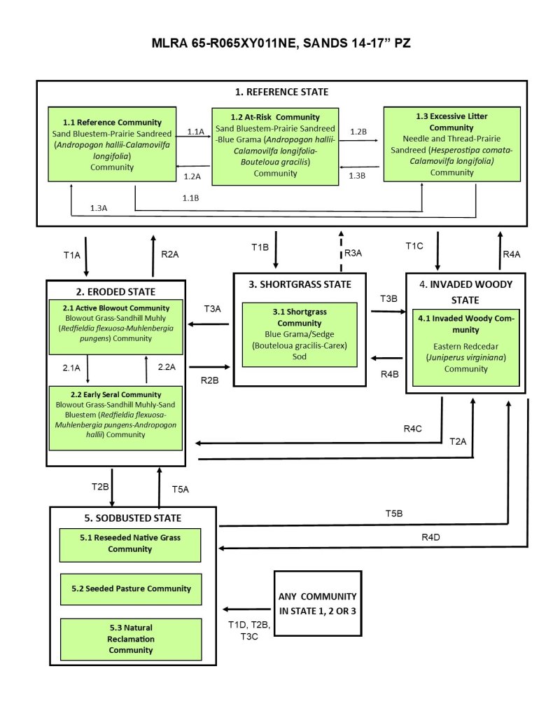
Figure 8. State and Transition Model Diagram, Sands 14-17" PZ Ecological Site, MLRA 65.
Figure 9. State and Transition Model Legend, Sands 14-17" PZ Ecological Site, MLRA 65.
More interactive model formats are also available.
View Interactive Models
More interactive model formats are also available.
View Interactive Models
Click on state and transition labels to scroll to the respective text
Ecosystem states
States 1, 5 and 2 (additional transitions)
| T1A | - | Frequent and severe defoliation, land disturbance, wind erosion. |
|---|---|---|
| T1B | - | Long-term (> 10 years), continuous season-long grazing or rotational grazing with inadequate recovery periods. |
| T1C | - | Woody encroachment with no fire or brush management. |
| T1D | - | Tillage to facilitate production agriculture. |
| R2A | - | Removal of disturbance with long-term (> 10 years) prescribed grazing. |
| R2B | - | Removal of disturbance with long-term (> 10 years) prescribed grazing. |
| T2A | - | Woody encroachment with no fire or brush management. |
| T2B | - | Tillage to facilitate production agriculture. |
| R3A | - | Long-term (>15 years) prescribed grazing with adequate growing season recovery time. This restoration may not be feasible. |
| T3A | - | Frequent and severe defoliation, land disturbance, wind erosion. |
| T3B | - | Woody encroachment with no fire or brush management. |
| T3C | - | Tillage to facilitate production agriculture. |
| R4A | - | Prescribed burning, timber harvest, brush management. |
| R4B | - | Prescribed burning, timber harvest, brush management. |
| R4C | - | Prescribed burning, timber harvest, brush management. |
| R4D | - | Prescribed burning, timber harvest, brush management. |
| T5A | - | Frequent and severe defoliation, land disturbance, wind erosion. |
| T5B | - | Woody encroachment with o fire or brush management. |
State 1 submodel, plant communities
| 1.1A | - | Heavy grazing. Moderate grazing with inadequate growing season recovery periods. |
|---|---|---|
| 1.1B | - | Prolonged (> 5 years) absence of herbivory and fire. |
| 1.2A | - | Prescribed grazing with adequate, growing season recovery time. |
| 1.2B | - | Prolonged (> 5 years) absence of herbivory and fire. |
| 1.3A | - | Prescribed grazing, prescribed burning. |
| 1.3B | - | Prescribed grazing, prescribed burning. |
State 2 submodel, plant communities
| 2.1A | - | Prescribed grazing that includes concentrated, short-term animal impact. |
|---|---|---|
| 2.2A | - | Heavy disturbance including heavy grazing or wildfire. |
State 3 submodel, plant communities
State 4 submodel, plant communities
State 5 submodel, plant communities
State 1
Reference State
The Reference State (1) describes the range of vegetative communities that occur on the Sands 14-17" PZ ecological site where the range of natural variability under historic conditions and disturbance regimes is mostly intact. The Reference State developed under the combined influences of climatic conditions, periodic fire activity, grazing by large herbivores, and impacts from small mammals and insects. High perennial grass cover and production allows for increased soil moisture retention, vegetative production and overall soil quality. The Reference State includes three community phases which are the Reference Community (1.1), the At-Risk Community (1.2) and the Excessive Litter Community (1.3), The Reference Community serves as a description of the native plant community that occurs on the site when the natural disturbance regimes are intact or closely mimicked by management practices. The At-Risk Community results from management actions that are unfavorable for a healthy Reference Community. The Excessive Litter Community occurs when herbivory and fire are eliminated from the landscape.
Dominant plant species
-
sand bluestem (Andropogon hallii), grass
-
prairie sandreed (Calamovilfa longifolia), grass
-
needle and thread (Hesperostipa comata ssp. comata), grass
-
blue grama (Bouteloua gracilis), grass
Community 1.1
Reference Community
Interpretations are primarily based on the Reference or Sand Bluestem-Prairie Sandreed (Andropogon hallii-Calamovilfa longifolia) Community (1.1). This plant community serves as a description of the native plant community that occurs on the site when the historic disturbance regimes are intact or are closely mimicked by management practices. This phase is dynamic, with fluid relative abundance and spatial boundaries between the dominant structural vegetative groups. These fluctuations are primarily driven by different responses of the species to changes in precipitation timing and abundance, and to fire and grazing events. This site developed with grazing by large herbivores and is well suited for grazing by domestic livestock. This plant community consists chiefly of warm-season, tall- and midgrasses. Sand bluestem and prairie sandreed are the dominant grasses. Grasses of secondary importance include needle and thread, little bluestem, switchgrass, and blue grama. Sedges occur in the understory. The forb population is diverse. Sand sagebrush, prairie sagewort, and rose are common shrubs. The potential vegetative composition is 85 to 90 percent grasses, 5 to 10 percent forbs, and 1 to 5 percent shrubs by weight. Natural fire played a significant role in the succession of this site by limiting the extent of shrubs. Wildfires have been actively controlled in recent times, facilitating tree and shrub encroachment. This plant community can be found on areas that are managed with prescribed grazing, prescribed burning, and may be found on areas receiving occasional periods of short-term rest. This resilient community is well adapted to the Northern Great Plains climatic conditions. Plant diversity promotes strong tolerance to drought, site and soil stability, a functional hydrologic cycle, and a high degree of biotic integrity. These factors create a suitable environment for a healthy and sustainable plant community.
Dominant plant species
-
sand bluestem (Andropogon hallii), grass
-
prairie sandreed (Calamovilfa longifolia), grass
Figure 10. Annual production by plant type (representative values) or group (midpoint values)
Table 5. Annual production by plant type
| Plant type | Low (lb/acre) |
Representative value (lb/acre) |
High (lb/acre) |
|---|---|---|---|
| Grass/Grasslike | 1495 | 1700 | 2205 |
| Forb | 90 | 145 | 195 |
| Shrub/Vine | 15 | 55 | 100 |
| Total | 1600 | 1900 | 2500 |
Figure 11. Plant community growth curve (percent production by month). NE6534, NE/SD Sandhills, Native Grasslands. Warm-season dominant, cool-season subdominant, mid- and tallgrasses.
| Jan | Feb | Mar | Apr | May | Jun | Jul | Aug | Sep | Oct | Nov | Dec |
|---|---|---|---|---|---|---|---|---|---|---|---|
| J | F | M | A | M | J | J | A | S | O | N | D |
| 5 | 5 | 15 | 25 | 30 | 10 | 7 | 3 |
Community 1.2
At-Risk Community
The At-Risk or Sand Bluestem-Prairie Sandreed-Blue Grama (Andropogon hallii-Calamovilfa longifolia-Bouteloua gracilis) Community (1.2) develops with continuous seasonal grazing, continuous season-long grazing, or rotational grazing with inadequate growing season recovery time. Species diversity is reduced compared to the Reference Community (1.1) due to continued defoliation of warm-season tall- and midgrasses during their critical growth periods. Prairie sandreed and sand bluestem have been reduced but remain dominant species while blue grama has increased due to its ability to withstand heavy grazing. Prairie sandreed, sand bluestem, and blue grama are the dominant grasses. Grasses of secondary importance include sand dropseed and needle and thread. Cuman ragweed, annual buckwheat, prairie spiderwort, and scurfpeas are frequent forbs. Sand sagebrush, brittle pricklypear, and soapweed are common shrubs. The potential vegetative composition is 85 to 95 percent grasses or grass-like plants, 1 to 10 percent forbs, and 1 to 5 percent shrubs. This plant community is not resistant to change. Changes in climate, fire patterns, or grazing management can result in the transition to another state. Soil erosion remains low. Runoff is low and infiltration is high due to soils and the presence of surface litter. With continuation of the management that caused this community to develop the warm- season tall- and midgrasses and cool-season bunch grasses will be further reduced while warm-season shortgrasses increase causing the community to be at risk of crossing an ecological threshold and transitioning to the Shortgrass State (3).
Dominant plant species
-
sand bluestem (Andropogon hallii), grass
-
prairie sandreed (Calamovilfa longifolia), grass
-
blue grama (Bouteloua gracilis), grass
Figure 12. Annual production by plant type (representative values) or group (midpoint values)
Table 6. Annual production by plant type
| Plant type | Low (lb/acre) |
Representative value (lb/acre) |
High (lb/acre) |
|---|---|---|---|
| Grass/Grasslike | 1385 | 1565 | 2035 |
| Forb | 15 | 85 | 175 |
| Shrub/Vine | 15 | 50 | 90 |
| Total | 1415 | 1700 | 2300 |
Figure 13. Plant community growth curve (percent production by month). NE6534, NE/SD Sandhills, Native Grasslands. Warm-season dominant, cool-season subdominant, mid- and tallgrasses.
| Jan | Feb | Mar | Apr | May | Jun | Jul | Aug | Sep | Oct | Nov | Dec |
|---|---|---|---|---|---|---|---|---|---|---|---|
| J | F | M | A | M | J | J | A | S | O | N | D |
| 5 | 5 | 15 | 25 | 30 | 10 | 7 | 3 |
Community 1.3
Excessive Litter Community
The Excessive Litter or Needle and Thread-Prairie Sandreed (Hesperostipa comata-Calamovilfa longifolia) Community (1.3) develops when the natural disturbances of livestock grazing and fire have been removed from the land for a prolonged period of time (more than five years). Plant litter accumulates rapidly as this community first develops. As the undisturbed duff layer deepens, infiltration of the precipitation is interrupted and evaporation increases significantly, simulating drought-like conditions. Typically, bunchgrasses have developed dead centers and rhizomatous grasses have formed small colonies due to a lack of tiller stimulation. Plant frequency and production have decreased. Pedestalling is usually evident. As grazing and fire continue to be excluded from the land, litter levels will increase to the point that few plants remain. As the accumulated litter decays, large areas of bare ground will develop, and non-native grasses will begin to invade the plant community. Prairie sandreed, and needle and thread are the dominant grasses. Other grasses that may be present include sand bluestem, sand dropseed, and little bluestem. The dominant forbs typically include annual sunflower and bractless mentzelia. The dominant shrubs present include rose and sand sagebrush. The potential vegetative composition is 80 to 90 percent grasses or grass-like plants, 5 to 15 percent forbs, and 2 to 5 percent shrubs. As compared to the Reference Community (1.1), plant diversity has decreased, and native plants tend to occur in individual colonies. This plant community has a high amount of litter covering the soil between widely dispersed mature plants. As the litter layer thickens, the health and vigor of native, warm-season, tall- and midgrasses declines. Soil erosion is low. Infiltration and runoff are not significantly different than the Reference Community. This plant community will change rapidly when grazing by domestic livestock or fire are reintroduced. If the intensity and duration of the disturbance is inadequate, the plant community will easily return to the Excessive Litter Community.
Figure 14. Annual production by plant type (representative values) or group (midpoint values)
Table 7. Annual production by plant type
| Plant type | Low (lb/acre) |
Representative value (lb/acre) |
High (lb/acre) |
|---|---|---|---|
| Grass/Grasslike | 1025 | 1220 | 1310 |
| Forb | 65 | 140 | 215 |
| Shrub/Vine | 10 | 40 | 75 |
| Total | 1100 | 1400 | 1600 |
Figure 15. Plant community growth curve (percent production by month). NE6536, NE/SD Sandhills, Native Grass, Non-Use. Warm-season dominant, cool-season subdominant, excessive litter.
| Jan | Feb | Mar | Apr | May | Jun | Jul | Aug | Sep | Oct | Nov | Dec |
|---|---|---|---|---|---|---|---|---|---|---|---|
| J | F | M | A | M | J | J | A | S | O | N | D |
| 0 | 0 | 5 | 15 | 20 | 20 | 20 | 10 | 7 | 3 | 0 | 0 |
Pathway 1.1A
Community 1.1 to 1.2
Grazing management that includes heavy grazing or moderate grazing with inadequate growing season recovery time between grazing periods will move the Reference Community (1.1) to the At-Risk Community (1.2). Heavy, continuous grazing accelerates this process.
Pathway 1.1B
Community 1.1 to 1.3
Prolonged (greater than five years) absence of the natural disturbances of herbivory and fire will move the Reference Community (1.1) to the Excessive Litter Community (1.3).
Pathway 1.2A
Community 1.2 to 1.1
At-Risk Community (1.2) can return to the Reference Community (1.1) with implementation of prescribed grazing with adequate growing season recovery periods. Prescribed burning may accelerate this process.
Pathway 1.2B
Community 1.2 to 1.3
Prolonged (more than five years) absence of the natural disturbances of herbivory and fire will move the At-Risk Community (1.2) to the Excessive Litter Community (1.3).
Pathway 1.3A
Community 1.3 to 1.1
Reintroduction of the natural processes of herbivory and fire will return the Excessive Litter Community (1.3) to the Reference Community (1.1). If grazing and fire were absent for extensive periods of time, their reintroduction will move the plant community to the At-Risk Community (1.2) and several additional years of prescribed grazing will be needed for the community to return to the Reference Community.
Pathway 1.3B
Community 1.3 to 1.2
Reintroduction of the natural processes of herbivory and fire will return the Excessive Litter Community (1.3) to the At-Risk Community (1.1).
State 2
Eroded State
The Eroded State (2) can be reached from any other plant community in the Reference State (1), the Shortgrass Sod State (3), or the Sodbusted State (4). This state is the result of heavy disturbance, usually frequent and severe defoliation. The Eroded State can also occur with vehicle traffic, livestock trailing or other heavy disturbances. Long-term drought or dormant season wildfire coupled with the heavy disturbance will accelerate the move to the Eroded State. The Eroded State (2) includes two plant communities which are the Blowout Community (2.1) and the Early Seral Community (2.2).
Dominant plant species
-
blowout grass (Redfieldia flexuosa), grass
-
sandhill muhly (Muhlenbergia pungens), grass
-
sand bluestem (Andropogon hallii), grass
-
lemon scurfpea (Psoralidium lanceolatum), other herbaceous
Community 2.1
Active Blowout Community
The Active Blowout or Blowout Grass-Sandhill Muhly (Redfieldia flexuosa-Muhlenbergia pungens) Community (2.1) can be reached from any plant community in Reference State (1) or Eroded State (2). The Active Blowout Community is characterized by large areas of blowing sand which results in movement, and possibly enlargement, of the blowout. Under these conditions, evaporation is extremely high and transpiration by the few existing plants is also high. The bare ground, lack of litter and low plant density all contribute to high evaporation and transpiration. This community is kept in a very low successional stage by the steep side slopes of the blowout, blowing sand, and lack of soil development. Sandhill muhly and blowout grass are present due to their drought tolerance and ability to withstand burial by blowing sand. The Active Blowout Community can be moved to the Early Seral Community (2.2) by removing the long term, concentrated animal impact or other existing disturbance and replacing it with prescribed grazing that incorporates concentrated short-term animal impact. This short-term animal impact can be achieved through activities such as feeding hay on the blowout. Establishment of vegetation may be accelerated by broadcast seeding a temporary cover crop prior to the removal of animal impact to provide cover to reduce wind erosion.
Dominant plant species
-
blowout grass (Redfieldia flexuosa), grass
-
sandhill muhly (Muhlenbergia pungens), grass
Community 2.2
Early Seral Community
As succession progresses, the Blowout Community (2.1) moves toward the Early Seral or Blowout grass-Sandhill Muhly-Sand Bluestem (Redfieldia flexuosa-Muhlenbergia pungens-Andropogon hallii) Community (2.2). Sandhill muhly, blowout grass, and sand bluestem are the earliest colonizers. Annual grasses such as sandbur are common. Lemon scurfpea, Texas croton, and common sunflower are common forbs. Prairie sandreed, hairy grama, and rose slowly become present the plant community and eventually other warm- season tall- and midgrasses will enter the plant community. Disturbances such as heavy grazing or dormant season wildfire will return the community to the Active Blowout Community. Long-term (greater than 10 years) prescribed grazing with incorporation of adequate, growing season recovery periods will move the plant community toward the previous State. The slope, aspect, and size of the area, as well as the relative abundance of perennial plants, will influence the amount of time required for this restoration.
Dominant plant species
-
blowout grass (Redfieldia flexuosa), grass
-
sandhill muhly (Muhlenbergia pungens), grass
-
sand bluestem (Andropogon hallii), grass
-
lemon scurfpea (Psoralidium lanceolatum), other herbaceous
-
common sunflower (Helianthus annuus), other herbaceous
Pathway 2.1A
Community 2.1 to 2.2
Prescribed grazing that includes concentrated short-term animal impact will move the Active Blowout Community (2.1) to the Early Seral Community (2.2). Concentrated animal impact is often accomplished by activities such as feeding hay on the blowout for short periods of time followed by growing season recovery periods.
Pathway 2.2A
Community 2.2 to 2.1
Any heavy disturbance, including heavy grazing or wildfire, which prevents adequate growing season recovery time between disturbance events will return the Early Seral Community (2.2) to the Active Blowout Community (2.1).
State 3
Shortgrass State
The Shortgrass State (3) transitioned from the Reference State (1) and much of the native warm-season tall- and midgrass components have been replaced by warm-season shortgrasses and upland sedges. Non-native cool-season grasses may have invaded the site. This State is the result of long-term grazing management that did not provide adequate recovery time for warm-season tall- and midgrasses and mid-statured cool-season grasses. The management that results in the Shortgrass State is typically heavy, continuous, season long grazing but heavy rotational grazing with inadequate growing season recovery periods can also cause this transition. The loss of warm-season tall- and midgrasses negatively impacts energy flow and nutrient cycling and alters hydrologic function. Runoff is higher and infiltration is lower than the Reference State. This state is very resistant to change. The Shortgrass State includes the Shortgrass Community (3.1).
Dominant plant species
-
sand sagebrush (Artemisia filifolia), shrub
-
soapweed yucca (Yucca glauca), shrub
-
blue grama (Bouteloua gracilis), grass
-
hairy grama (Bouteloua hirsuta), grass
-
needle and thread (Hesperostipa comata ssp. comata), grass
Community 3.1
Shortgrass Community
The Shortgrass or Blue Grama/Sedge (Bouteloua gracilis/Carex) Community (2.1) represents a transition from the Reference State (1) across an ecologic threshold. This community develops with long-term heavy grazing with inadequate growing season recovery periods. Typically, the type of grazing is continuous season long, but this community may also develop with heavy rotational grazing when plants have not recovered before pastures are re-entered. This community also develops in large pastures that are moderately stocked when individual plants are grazed repeatedly. With continued grazing pressure, native shortgrasses become dominant with only remnants of the more palatable grasses. Continuous and heavy grazing pressure will maintain this community in a sod-bound condition. Blue grama is the dominant grass. Needle and thread, prairie sandreed, and sedges are the secondary species. The forb diversity is limited. Sand sagebrush and soapweed yucca are common shrubs. Cheatgrass may have a significant presence. The potential vegetative composition is 85 to 95 percent grasses and grass-likes, 0 to 10 percent forbs, and 0 to 5 percent shrubs. Species diversity is low contributing to the lack of resilience with disturbance. Compared to the Reference Community (1.1) warm-season tall- and midgrasses are substantially reduced and may be absent while warm-season shortgrasses have significantly increased. Plant diversity is low both in terms of individual species and functional or structural groups. Biotic integrity is reduced as compared to the Reference Community (1.1). The potential for soil erosion is moderate and has increased as compared to the Reference State. This plant community is not resistant to change due to the high percentage of bare ground present. The loss of warm-season tall- and midgrasses has negatively impacted energy flow and nutrient cycling. The hydrologic cycle is impaired by the increased runoff, decreased infiltration, and the lack of surface litter which contributes to increased evaporation.
Dominant plant species
-
soapweed yucca (Yucca glauca), shrub
-
sand sagebrush (Artemisia filifolia), shrub
-
blue grama (Bouteloua gracilis), grass
-
needle and thread (Hesperostipa comata ssp. comata), grass
-
hairy grama (Bouteloua hirsuta), grass
-
sedge (Carex), other herbaceous
Figure 16. Annual production by plant type (representative values) or group (midpoint values)
Table 8. Annual production by plant type
| Plant type | Low (lb/acre) |
Representative value (lb/acre) |
High (lb/acre) |
|---|---|---|---|
| Grass/Grasslike | 975 | 1200 | 1400 |
| Forb | 25 | 65 | 135 |
| Shrub/Vine | 0 | 35 | 65 |
| Total | 1000 | 1300 | 1600 |
Figure 17. Plant community growth curve (percent production by month). NE6535, NE/SD Sandhills Blue Grama dominant. Warm-season dominant, short grass.
| Jan | Feb | Mar | Apr | May | Jun | Jul | Aug | Sep | Oct | Nov | Dec |
|---|---|---|---|---|---|---|---|---|---|---|---|
| J | F | M | A | M | J | J | A | S | O | N | D |
| 0 | 0 | 0 | 5 | 15 | 30 | 25 | 15 | 10 | 0 | 0 | 0 |
State 4
Invaded Woody State
The Invaded Woody State (4) is the result of woody encroachment. Once the tree canopy cover reaches 15 percent with an average tree height exceeding five feet, the threshold to the Invaded Woody State has been crossed. Woody species are increasing due to the lack of prescribed fire, brush management, or other woody tree removal. Typical ecological impacts are a loss of native grasses, reduce diversity of functional and structural groups, reduced forage production, and reduced soil quality. Prescribed burning, wildfire, timber harvest and brush management will move the Invaded Woody State toward a grass dominated state. If the Invaded Woody State transitioned from Eroded State (2), the Shortgrass State (3) or the Sodbusted State (5), the land cannot return to the Reference State (1) as the native plant community, soils, and hydrologic function had been too severely impacted prior to the woody encroachment to allow the return to the Reference State through woody species removal alone. The Invaded Woody State includes one community, the Invaded Woody Community (4.1).
Dominant plant species
-
eastern redcedar (Juniperus virginiana), tree
-
sand sagebrush (Artemisia filifolia), shrub
-
soapweed yucca (Yucca glauca), shrub
-
needle and thread (Hesperostipa comata ssp. comata), grass
-
blue grama (Bouteloua gracilis), grass
-
Kentucky bluegrass (Poa pratensis), grass
Community 4.1
Invaded Woody Community
The Invaded Woody Community or Eastern Redcedar (Juniperus virginiana) Community (4.1) has at least 15 percent canopy cover consisting of trees generally 5 feet or taller or shrubs. The dominant woody species may be shrubs, typically sand sagebrush or soapweed yucca or trees, typically eastern redcedar. In the absence of fire and brush management, this ecological site is very susceptible to eastern redcedar seedling invasion, especially when adjacent to a seed source. Eastern redcedar, sand sagebrush, or other shrubs can eventually dominate the site which drastically reduces forage production, and which has limited value for either livestock grazing or wildlife habitat. With properly managed intensive grazing, encroachment of deciduous trees will typically be minimal; however, this type of management will not impact encroachment of coniferous species or unpalatable shrubs such as sand sagebrush. The herbaceous component decreases proportionately in relation to the percent canopy cover, with the reduction being greater under a coniferous overstory. Eastern redcedar control can usually be accomplished with prescribed burning while the trees are six feet tall or less and fine fuel production is greater than 1,500 pounds per acres. Larger redcedars can also be controlled with prescribed burning, but successful application requires the use of specifically designed ignition and holding techniques (https://www.loesscanyonsburning group.com). Resprouting brush must be chemically treated immediately after mechanical removal to achieve effective treatment. Often the forb component will initially increase following woody species removal. To prevent return to a woody dominated community, ongoing brush management such as hand cutting, chemical spot treatments, or periodic prescribed burning is required. This plant community is resistant to change and resilient given normal disturbances. In higher canopy cover situations, the soil erosion will increase in relation the plant community from which this plant community originated. The hydrologic function is also significantly altered under higher canopy cover. Infiltration is reduced and runoff is typically increased because of a lack of herbaceous cover and the rooting structure provided by the herbaceous species. Total annual production during an average year varies significantly, depending on the production level prior to encroachment and the percentage of canopy cover.
Dominant plant species
-
eastern redcedar (Juniperus virginiana), tree
-
sand sagebrush (Artemisia filifolia), shrub
-
soapweed yucca (Yucca glauca), shrub
-
needle and thread (Hesperostipa comata ssp. comata), grass
-
blue grama (Bouteloua gracilis), grass
-
sedge (Carex), grass
-
Kentucky bluegrass (Poa pratensis), grass
State 5
Sodbusted State
The threshold to the Sodbusted State (5) is crossed as a result of mechanical disturbance to facilitate production agriculture. If farming operations are suspended, the site can be seeded to native grasses resulting in the Reseeded Native Grass Community (5.1), be seeded to a tame pasture forage mixture resulting in the Seeded Pasture Community (5.2) or be abandoned with no seeding which will result in the Natural Reclamation Community (5.3). Permanent alterations of the soil, plant community, and hydrologic cycle make restoration to the Reference State (1) extremely difficult, if not impossible.
Community 5.1
Reseeded Native Grass Community
The Reseeded Native Grass Community (5.1) does not contain native remnants, and varies considerably depending upon the seed mixture, the degree of soil erosion, the age of the stand, fertility management, and past grazing management. Native rangeland and grasslands seeded to native species are ecologically different and should be managed separately. Factors such as functional group, species, stand density, and improved varieties all impact the production level and palatability of the seedings. Species diversity is often limited, and when grazed in conjunction with native rangelands, uneven forage utilization may occur. Total annual production during an average year varies significantly depending upon precipitation, management, and grass species seeded. Prescribed grazing including appropriate utilization levels, adequate growing-season recovery periods, and timing of grazing that favor the productivity, health, and vigor of the seeded species is required to maintain this community. Periodic prescribed burning and brush management may also be needed.
Community 5.2
Seeded Pasture Community
The Seeded Pasture Community (5.2) does not contain native remnants and varies considerably depending upon the extent of soil erosion, the species seeded, the quality of the stand that was established, the age of the stand, and management of the stand since establishment. There are several factors that make seeded tame pasture a different grazing resource than native rangeland and land seeded to a native grass mixture. Factors such as species selected, stand density, improved varieties, and harvest efficiency all impact production levels and palatability. Species diversity on seeded tame pasture is often limited to a few species. When seeded pasture and native rangelands or seeded pasture and seeded rangeland are in the same grazing unit, uneven forage utilization will occur. Improve forage utilization and stand longevity by managing this community separately from native rangelands or land seeded to native grass species. Total annual production during an average year varies significantly depending on the level of management and species seeded. Improved varieties of warm-season or cool-season grasses are recommended for optimum forage production. Fertilization, weed management, and prescribed grazing including appropriate utilization levels, adequate growing-season recovery periods, and timing of grazing that favor the productivity, health, and vigor of the seeded species are required to maintain this community. Periodic prescribed burning and brush management may also be needed.
Community 5.3
Natural Reclamation Community
The Natural Reclamation Community (5.3) consists of annual and perennial early successional species. Perennial threeawns, sand dropseed, and annual grasses are common species. These sites have been farmed and abandoned without being reseeded. Soil organic matter and carbon reserves are reduced, soil structure is changed, and a plowpan or compacted layer can form, which decreases water infiltration. Residual synthetic chemicals may remain from farming operations. In early successional stages, this community is not stable. The hazard of erosion is a resource concern. Total annual production during an average year varies significantly depending on the succession stage of the plant community and any management applied to the system.
Transition T1A
State 1 to 2
The Eroded State (2) can be reached from any plant community of the Reference State (1). The Eroded State occurs with frequent and severe defoliation. Heavy, continuous grazing most often causes this transition, but it can also occur with rotational grazing when plants are not given adequate growing season recovery time before the paddocks or pastures are re-grazed. This process is accelerated when accompanied by additional disturbances, such as dormant season wildfire or extended drought. Heavy disturbance, such as vehicle traffic or livestock trailing can also cause this transition. The reduction in plant canopy and litter cover allows wind erosion to develop, creating large areas of blowing sand.
Transition T1B
State 1 to 3
The Reference State (1) transitions to the Shortgrass State (3) in response to long-term (greater than ten years), heavy, repeated defoliation of the key forage species (sand bluestem and prairie sandreed) by grazing or haying. This change typically occurs with long-term heavy, continuous season long grazing but heavy rotational grazing without adequate recovery periods may also cause this transition. The Reference State loses a significant proportion of warm-season, tall- and midgrasses and crosses a threshold to the Shortgrass Sod State. Deep rooted plants are replaced by shallow rooted, sod- forming grasses which tend to form root mats and water infiltration is reduced. Forage production and plant species diversity has declined. Initially, the plant community will be a mosaic, with shortgrass and mixed grass communities intermingled but as the management continues the plant community becomes dominated by shortgrasses.
Transition T1C
State 1 to 4
Long-term (more than ten years) disruption of the natural fire regime and the encroachment of invasive exotic and native woody species with no woody species management can cause the Reference State (1) to transition to the Invaded Woody State (4).
Transition T1D
State 1 to 5
The Reference State (1) has been significantly altered by tillage to facilitate production agriculture. When the land is no longer cropped, the resulting state is the Sodbusted State (5).
Restoration pathway R2A
State 2 to 1
The Eroded State (2) can be restored to the Reference State (1) with long term (10 or more years) grazing management that incorporates adequate growing season recovery periods (deferment). When either human-caused disturbance or livestock concentration caused the transition from the Reference State, removal of the disturbance along with appropriate grazing management is needed. With long term prescribed grazing, succession progresses, and the land will eventually return to the Reference State.
Transition R2B
State 2 to 3
The Eroded State (2) can be returned to the Shortgrass State (3) with long term (10 or more years) grazing management that incorporates adequate growing season recovery periods (deferment). When either human-caused disturbance or livestock concentration caused the transition from the Shortgrass Sod State, removal of the disturbance along with appropriate grazing management is needed. With long term prescribed grazing, succession progresses, and the land will eventually return to the Reference State.
Transition T2A
State 2 to 4
Long-term (more than ten years) disruption of the natural fire regime and the encroachment of invasive exotic and native woody species with no woody species management can cause the Eroded State (2) to transition to the Invaded Woody State (4).
Transition T2B
State 2 to 5
The Eroded State (2) can be returned to the Sodbusted State (5) with long term (10 or more years) prescribed grazing. Initially, grazing management that incorporates concentrated short- term animal impact (such as feeding hay on the blowout) will encourage growth of early successional grasses and forbs. When either human-caused disturbance or livestock concentration caused the transition to the Eroded State, removal of the disturbance along with appropriate grazing management is needed. With long term prescribed grazing, succession progresses, and the land will eventually return to the Sodbusted State. Re-seeding may be needed to return to any community other than the Natural Reclamation Community (5.3).
Restoration pathway R3A
State 3 to 1
Long-term (more than 15 years) prescribed grazing with adequate growing season recovery periods will move the Shortgrass State (3) toward the Reference State (1). The amount of time required for, and feasibility of this restoration depends upon the abundance of warm-season tall- and midgrasses and cool-season bunch grasses remaining in the plant community. This restoration may not be feasible.
Transition T3A
State 3 to 2
The Shortgrass State (3) transitions to the Eroded State (2) with frequent and severe defoliation. Heavy, continuous grazing often causes this transition, but it can also occur with rotational grazing when plants are not given adequate growing season recovery time before the paddocks or pastures are re-grazed. This process is accelerated when accompanied by additional disturbances, such as dormant season wildfire or extended drought. Heavy disturbance, such as vehicle traffic or livestock trailing can also cause this transition. The reduction in plant canopy and litter cover allows wind erosion to develop, creating large areas of blowing sand.
Transition T3B
State 3 to 4
Long-term (more than ten years) disruption of the natural fire regime and the encroachment of invasive exotic and native woody species with no woody species management can cause the Shortgrass State (3) to transition to the Invaded Woody State (4).
Transition T3C
State 3 to 5
The Shortgrass State (3) has been significantly altered by tillage to facilitate production agriculture. When the land is no longer cropped, the resulting state is the Sodbusted State (5).
Restoration pathway R4A
State 4 to 1
The Invaded Woody State (4) can be restored to the Reference State (1) through prescribed burning, wildfire, timber harvest, or brush management. The forb component may initially increase following tree removal. Ongoing brush management such as hand cutting, chemical spot treatments, or periodic prescribed burning is required to prevent a return to the Invaded Woody State. The heavier the existing canopy cover, the greater the energy input required to return to the Native/Invaded Grass State by management practices. The amount of time required for this restoration to occur depends on the severity and duration of the encroachment. Land that transitioned to the Invaded Woody State from the Eroded State (2), the Shortgrass State (3), or the Sodbusted State (5) cannot be restored to the Reference State through the removal of woody species as the native plant community, soils, and hydrologic function have been too severely impacted for that restoration to occur with removal of woody species alone.
Restoration pathway R4B
State 4 to 2
The Invaded Woody State (4) can be restored to the Eroded State (2) through prescribed burning, wildfire, timber harvest, or brush management. The forb component may initially increase following tree removal. Ongoing brush management such as hand cutting, chemical spot treatments, or periodic prescribed burning is required to prevent a return to the Invaded Woody State. The heavier the existing canopy cover, the greater the energy input required to return to the Native/Invaded Grass State by management practices. The amount of time required for this restoration to occur depends on the severity and duration of the encroachment. Land that transitioned to the Invaded Woody State from the Eroded State (2) cannot be restored to the Reference State through the removal of woody species as the native plant community, soils, and hydrologic function have been too severely impacted for that restoration to occur with removal of woody species alone.
Restoration pathway R4C
State 4 to 3
The Invaded Woody State (4) can be restored to the Shortgrass State (3) through prescribed burning, wildfire, timber harvest, or brush management. The forb component may initially increase following tree removal. Ongoing brush management such as hand cutting, chemical spot treatments, or periodic prescribed burning is required to prevent a return to the Invaded Woody State. The heavier the existing canopy cover, the greater the energy input required to return to the Native/Invaded Grass State by management practices. The amount of time required for this restoration to occur depends on the severity and duration of the encroachment. Land that transitioned to the Invaded Woody State from the Shortgrass State (3) cannot be restored to the Reference State through the removal of woody species as the native plant community, soils, and hydrologic function have been too severely impacted for that restoration to occur with removal of woody species alone.
Restoration pathway R4D
State 4 to 5
The Invaded Woody State (4) can be restored to the Sodbusted State (5) through prescribed burning, wildfire, timber harvest, or brush management. The forb component may initially increase following tree removal. Ongoing brush management such as hand cutting, chemical spot treatments, or periodic prescribed burning is required to prevent a return to the Invaded Woody State. The heavier the existing canopy cover, the greater the energy input required to return to the Sodbusted State by management practices. The amount of time required for this restoration to occur depends on the severity and duration of the encroachment. Land that transitioned to the Invaded Woody State from Sodbusted State cannot be restored to the Reference State (1) through the removal of woody species as the native plant community, soils, and hydrologic function have been too severely impacted for that restoration to occur with removal of brush alone.
Transition T5A
State 5 to 2
The Sodbusted State (5) will transition to the Eroded State (2) with frequent and severe defoliation. Heavy, continuous grazing often causes this transition, but it can also occur with rotational grazing when plants are not given adequate growing season recovery time before the paddocks or pastures are re-grazed. This process is accelerated when accompanied by additional disturbances, such as dormant season wildfire or extended drought. Heavy disturbance, such as vehicle traffic or livestock trailing can also cause this transition. The reduction in plant canopy and litter cover allows wind erosion to develop, creating large areas of blowing sand.
Transition T5B
State 5 to 4
Long-term (more than ten years) disruption of the natural fire regime and the encroachment of invasive exotic and native woody species with no woody species management can cause the Sodbusted State (5) to transition to the Invaded Woody State (4).
Additional community tables
Table 9. Community 1.1 plant community composition
| Group | Common name | Symbol | Scientific name | Annual production (lb/acre) | Foliar cover (%) | |
|---|---|---|---|---|---|---|
|
Grass/Grasslike
|
||||||
| 1 | Warm-Season Tallgrass | 760–1140 | ||||
| sand bluestem | ANHA | Andropogon hallii | 380–760 | – | ||
| prairie sandreed | CALO | Calamovilfa longifolia | 380–760 | – | ||
| switchgrass | PAVI2 | Panicum virgatum | 0–95 | – | ||
| Grass, perennial | 2GP | Grass, perennial | 0–57 | – | ||
| 2 | Warm-Season Midgrass | 95–285 | ||||
| sand lovegrass | ERTR3 | Eragrostis trichodes | 95–190 | – | ||
| little bluestem | SCSC | Schizachyrium scoparium | 0–190 | – | ||
| sand dropseed | SPCR | Sporobolus cryptandrus | 0–95 | – | ||
| blowout grass | REFL | Redfieldia flexuosa | 0–95 | – | ||
| Grass, perennial | 2GP | Grass, perennial | 0–38 | – | ||
| 3 | Warm-Season Shortgrass | 95–190 | ||||
| blue grama | BOGR2 | Bouteloua gracilis | 19–190 | – | ||
| hairy grama | BOHI2 | Bouteloua hirsuta | 19–95 | – | ||
| sandhill muhly | MUPU2 | Muhlenbergia pungens | 0–95 | – | ||
| thin paspalum | PASE5 | Paspalum setaceum | 0–38 | – | ||
| Grass, perennial | 2GP | Grass, perennial | 0–38 | – | ||
| 4 | Cool-Season Bunchgrass | 95–285 | ||||
| needle and thread | HECOC8 | Hesperostipa comata ssp. comata | 95–190 | – | ||
| prairie Junegrass | KOMA | Koeleria macrantha | 19–95 | – | ||
| Grass, perennial | 2GP | Grass, perennial | 0–38 | – | ||
| Indian ricegrass | ACHY | Achnatherum hymenoides | 0–38 | – | ||
| 5 | Grass-likes | 19–95 | ||||
| sedge | CAREX | Carex | 19–95 | – | ||
|
Forb
|
||||||
| 6 | Forbs | 95–190 | ||||
| Forb, annual | 2FA | Forb, annual | 0–38 | – | ||
| Forb, perennial | 2FP | Forb, perennial | 0–38 | – | ||
| Cuman ragweed | AMPS | Ambrosia psilostachya | 0–19 | – | ||
| tarragon | ARDR4 | Artemisia dracunculus | 0–19 | – | ||
| sand milkweed | ASAR | Asclepias arenaria | 0–19 | – | ||
| tarragon | ARDR4 | Artemisia dracunculus | 0–19 | – | ||
| common sunflower | HEAN3 | Helianthus annuus | 0–19 | – | ||
| dotted blazing star | LIPU | Liatris punctata | 0–19 | – | ||
| scaly blazing star | LISQ | Liatris squarrosa | 0–19 | – | ||
| rush skeletonplant | LYJU | Lygodesmia juncea | 0–19 | – | ||
| bractless blazingstar | MENU | Mentzelia nuda | 0–19 | – | ||
| broadbeard beardtongue | PEAN4 | Penstemon angustifolius | 0–19 | – | ||
| slimflower scurfpea | PSTE5 | Psoralidium tenuiflorum | 0–19 | – | ||
| palmleaf Indian breadroot | PEDI9 | Pediomelum digitatum | 0–19 | – | ||
| Riddell's ragwort | SERI2 | Senecio riddellii | 0–19 | – | ||
| white heath aster | SYER | Symphyotrichum ericoides | 0–19 | – | ||
| prairie spiderwort | TROC | Tradescantia occidentalis | 0–19 | – | ||
|
Shrub/Vine
|
||||||
| 7 | Shrubs | 19–95 | ||||
| sand sagebrush | ARFI2 | Artemisia filifolia | 19–57 | – | ||
| prairie sagewort | ARFR4 | Artemisia frigida | 19–57 | – | ||
| rose | ROSA5 | Rosa | 19–57 | – | ||
| soapweed yucca | YUGL | Yucca glauca | 19–57 | – | ||
| Subshrub (<.5m) | 2SUBS | Subshrub (<.5m) | 19–57 | – | ||
| western sandcherry | PRPUB | Prunus pumila var. besseyi | 19–38 | – | ||
| brittle pricklypear | OPFR | Opuntia fragilis | 0–19 | – | ||
Table 10. Community 1.2 plant community composition
| Group | Common name | Symbol | Scientific name | Annual production (lb/acre) | Foliar cover (%) | |
|---|---|---|---|---|---|---|
|
Grass/Grasslike
|
||||||
| 1 | Warm-Season Tallgrass | 765–1020 | ||||
| sand bluestem | ANHA | Andropogon hallii | 425–595 | – | ||
| prairie sandreed | CALO | Calamovilfa longifolia | 340–510 | – | ||
| Grass, perennial | 2GP | Grass, perennial | 0–85 | – | ||
| 2 | Warm-Season Midgrass | 0–170 | ||||
| little bluestem | SCSC | Schizachyrium scoparium | 0–85 | – | ||
| sand dropseed | SPCR | Sporobolus cryptandrus | 0–85 | – | ||
| Grass, perennial | 2GP | Grass, perennial | 0–85 | – | ||
| sand lovegrass | ERTR3 | Eragrostis trichodes | 0–18 | – | ||
| 3 | Warm-Season Shortgrass | 85–255 | ||||
| blue grama | BOGR2 | Bouteloua gracilis | 85–170 | – | ||
| hairy grama | BOHI2 | Bouteloua hirsuta | 0–85 | – | ||
| sandhill muhly | MUPU2 | Muhlenbergia pungens | 0–85 | – | ||
| thin paspalum | PASE5 | Paspalum setaceum | 0–34 | – | ||
| Grass, perennial | 2GP | Grass, perennial | 0–34 | – | ||
| 4 | Cool-Season Bunchgrass | 17–170 | ||||
| needle and thread | HECOC8 | Hesperostipa comata ssp. comata | 0–85 | – | ||
| prairie Junegrass | KOMA | Koeleria macrantha | 0–85 | – | ||
| Grass, perennial | 2GP | Grass, perennial | 0–34 | – | ||
| Indian ricegrass | ACHY | Achnatherum hymenoides | 0–34 | – | ||
| 5 | Grass-like | 17–85 | ||||
| sedge | CAREX | Carex | 17–85 | – | ||
| 8 | Non-Native Grass | 0–34 | ||||
| cheatgrass | BRTE | Bromus tectorum | 0–34 | – | ||
|
Forb
|
||||||
| 6 | Forb | 85–170 | ||||
| Forb, annual | 2FA | Forb, annual | 0–34 | – | ||
| Forb, perennial | 2FP | Forb, perennial | 0–34 | – | ||
| Cuman ragweed | AMPS | Ambrosia psilostachya | 0–17 | – | ||
| thistle | CIRSI | Cirsium | 0–17 | – | ||
| thistle | CIRSI | Cirsium | 0–17 | – | ||
| common sunflower | HEAN3 | Helianthus annuus | 0–17 | – | ||
| dotted blazing star | LIPU | Liatris punctata | 0–17 | – | ||
| scaly blazing star | LISQ | Liatris squarrosa | 0–17 | – | ||
| rush skeletonplant | LYJU | Lygodesmia juncea | 0–17 | – | ||
| bractless blazingstar | MENU | Mentzelia nuda | 0–17 | – | ||
| broadbeard beardtongue | PEAN4 | Penstemon angustifolius | 0–17 | – | ||
| slimflower scurfpea | PSTE5 | Psoralidium tenuiflorum | 0–17 | – | ||
| silverleaf Indian breadroot | PEAR6 | Pediomelum argophyllum | 0–17 | – | ||
| palmleaf Indian breadroot | PEDI9 | Pediomelum digitatum | 0–17 | – | ||
| prairie spiderwort | TROC | Tradescantia occidentalis | 0–17 | – | ||
| annual buckwheat | ERAN4 | Eriogonum annuum | 0–17 | – | ||
|
Shrub/Vine
|
||||||
| 7 | Shrub | 17–85 | ||||
| sand sagebrush | ARFI2 | Artemisia filifolia | 17–51 | – | ||
| prairie sagewort | ARFR4 | Artemisia frigida | 0–51 | – | ||
| rose | ROSA5 | Rosa | 0–51 | – | ||
| soapweed yucca | YUGL | Yucca glauca | 17–51 | – | ||
| Shrub (>.5m) | 2SHRUB | Shrub (>.5m) | 0–34 | – | ||
| brittle pricklypear | OPFR | Opuntia fragilis | 0–18 | – | ||
Table 11. Community 1.3 plant community composition
| Group | Common name | Symbol | Scientific name | Annual production (lb/acre) | Foliar cover (%) | |
|---|---|---|---|---|---|---|
|
Grass/Grasslike
|
||||||
| 1 | Warm-Season Tallgrass | 210–350 | ||||
| prairie sandreed | CALO | Calamovilfa longifolia | 140–210 | – | ||
| sand bluestem | ANHA | Andropogon hallii | 70–140 | – | ||
| switchgrass | PAVI2 | Panicum virgatum | 0–70 | – | ||
| Grass, perennial | 2GP | Grass, perennial | 0–28 | – | ||
| 2 | Warm-Season Midgrass | 28–140 | ||||
| little bluestem | SCSC | Schizachyrium scoparium | 0–140 | – | ||
| sand dropseed | SPCR | Sporobolus cryptandrus | 0–70 | – | ||
| sand lovegrass | ERTR3 | Eragrostis trichodes | 0–70 | – | ||
| blowout grass | REFL | Redfieldia flexuosa | 0–70 | – | ||
| Grass, perennial | 2GP | Grass, perennial | 0–28 | – | ||
| 3 | Warm-Season Shortgrass | 28–70 | ||||
| blue grama | BOGR2 | Bouteloua gracilis | 14–70 | – | ||
| hairy grama | BOHI2 | Bouteloua hirsuta | 14–70 | – | ||
| sandhill muhly | MUPU2 | Muhlenbergia pungens | 0–70 | – | ||
| thin paspalum | PASE5 | Paspalum setaceum | 0–28 | – | ||
| Grass, perennial | 2GP | Grass, perennial | 0–14 | – | ||
| 4 | Cool-Season Bunchgrass | 280–490 | ||||
| needle and thread | HECOC8 | Hesperostipa comata ssp. comata | 280–420 | – | ||
| prairie Junegrass | KOMA | Koeleria macrantha | 14–70 | – | ||
| Grass, perennial | 2GP | Grass, perennial | 0–70 | – | ||
| Indian ricegrass | ACHY | Achnatherum hymenoides | 0–28 | – | ||
| Scribner's rosette grass | DIOLS | Dichanthelium oligosanthes var. scribnerianum | 0–28 | – | ||
| 5 | Grass-like | 0–28 | ||||
| sedge | CAREX | Carex | 0–28 | – | ||
| 8 | Non-Native Grass | 0–28 | ||||
| cheatgrass | BRTE | Bromus tectorum | 0–28 | – | ||
|
Forb
|
||||||
| 6 | Forb | 70–210 | ||||
| common sunflower | HEAN3 | Helianthus annuus | 0–140 | – | ||
| Forb, annual | 2FA | Forb, annual | 0–28 | – | ||
| Forb, perennial | 2FP | Forb, perennial | 0–28 | – | ||
| dotted blazing star | LIPU | Liatris punctata | 0–14 | – | ||
| scaly blazing star | LISQ | Liatris squarrosa | 0–14 | – | ||
| rush skeletonplant | LYJU | Lygodesmia juncea | 0–14 | – | ||
| bractless blazingstar | MENU | Mentzelia nuda | 0–14 | – | ||
| broadbeard beardtongue | PEAN4 | Penstemon angustifolius | 0–14 | – | ||
| slimflower scurfpea | PSTE5 | Psoralidium tenuiflorum | 0–14 | – | ||
| silverleaf Indian breadroot | PEAR6 | Pediomelum argophyllum | 0–14 | – | ||
| Missouri goldenrod | SOMI2 | Solidago missouriensis | 0–14 | – | ||
| white heath aster | SYER | Symphyotrichum ericoides | 0–14 | – | ||
| prairie spiderwort | TROC | Tradescantia occidentalis | 0–14 | – | ||
| Cuman ragweed | AMPS | Ambrosia psilostachya | 0–14 | – | ||
| tarragon | ARDR4 | Artemisia dracunculus | 0–14 | – | ||
| thistle | CIRSI | Cirsium | 0–14 | – | ||
|
Shrub/Vine
|
||||||
| 7 | Shrub | 14–70 | ||||
| sand sagebrush | ARFI2 | Artemisia filifolia | 14–70 | – | ||
| prairie sagewort | ARFR4 | Artemisia frigida | 14–42 | – | ||
| rose | ROSA5 | Rosa | 14–42 | – | ||
| soapweed yucca | YUGL | Yucca glauca | 14–42 | – | ||
| Shrub (>.5m) | 2SHRUB | Shrub (>.5m) | 7–35 | – | ||
| brittle pricklypear | OPFR | Opuntia fragilis | 0–14 | – | ||
| western sandcherry | PRPUB | Prunus pumila var. besseyi | 0–14 | – | ||
Table 12. Community 3.1 plant community composition
| Group | Common name | Symbol | Scientific name | Annual production (lb/acre) | Foliar cover (%) | |
|---|---|---|---|---|---|---|
|
Grass/Grasslike
|
||||||
| 1 | Warm-Season Tallgrass | 0–130 | ||||
| prairie sandreed | CALO | Calamovilfa longifolia | 0–130 | – | ||
| Grass, perennial | 2GP | Grass, perennial | 0–26 | – | ||
| 2 | Warm-Season Midgrass | 0–65 | ||||
| sand dropseed | SPCR | Sporobolus cryptandrus | 0–65 | – | ||
| Grass, perennial | 2GP | Grass, perennial | 0–26 | – | ||
| 3 | Warm-Season Shortgrass | 325–455 | ||||
| blue grama | BOGR2 | Bouteloua gracilis | 325–455 | – | ||
| Grass, perennial | 2GP | Grass, perennial | 0–26 | – | ||
| 4 | Cool-Season Bunchgrass | 130–260 | ||||
| needle and thread | HECOC8 | Hesperostipa comata ssp. comata | 130–260 | – | ||
| prairie Junegrass | KOMA | Koeleria macrantha | 0–65 | – | ||
| Grass, perennial | 2GP | Grass, perennial | 0–26 | – | ||
| 5 | Grass-like | 65–130 | ||||
| sedge | CAREX | Carex | 65–130 | – | ||
| 9 | Non-Native Grass | 0–26 | ||||
| cheatgrass | BRTE | Bromus tectorum | 0–26 | – | ||
|
Forb
|
||||||
| 6 | Forb | 0–130 | ||||
| Forb, annual | 2FA | Forb, annual | 0–26 | – | ||
| Forb, perennial | 2FP | Forb, perennial | 0–26 | – | ||
| Cuman ragweed | AMPS | Ambrosia psilostachya | 0–13 | – | ||
| tarragon | ARDR4 | Artemisia dracunculus | 0–13 | – | ||
| thistle | CIRSI | Cirsium | 0–13 | – | ||
| common sunflower | HEAN3 | Helianthus annuus | 0–13 | – | ||
| rush skeletonplant | LYJU | Lygodesmia juncea | 0–13 | – | ||
| bractless blazingstar | MENU | Mentzelia nuda | 0–13 | – | ||
| prairie spiderwort | TROC | Tradescantia occidentalis | 0–13 | – | ||
|
Shrub/Vine
|
||||||
| 7 | Shrub | 0–65 | ||||
| prairie sagewort | ARFR4 | Artemisia frigida | 0–65 | – | ||
| brittle pricklypear | OPFR | Opuntia fragilis | 0–13 | – | ||
| soapweed yucca | YUGL | Yucca glauca | 0–13 | – | ||
| Shrub (>.5m) | 2SHRUB | Shrub (>.5m) | 0–13 | – | ||
| sand sagebrush | ARFI2 | Artemisia filifolia | 0–13 | – | ||
Interpretations
Animal community
LIVESTOCK - GRAZING INTERPRETATIONS:
Grazing by domestic livestock is one of the major income-producing industries in the area. Rangeland in this area may provide year-long forage for cattle, sheep, or horses. During the dormant period, the protein levels of the forage may be lower than the minimum needed to meet livestock (primarily cattle and sheep) requirements. The following table lists suggested stocking rates for cattle under
continuous season-long grazing under normal growing conditions. These are conservative estimates that should be used only as guidelines in the initial stages of the conservation planning process. Often, the current plant composition does not entirely match any particular plant community (as described in this ecological site description). Because of this, a field visit is recommended, in all cases, to document plant composition and production. More precise carrying capacity estimates should eventually be calculated using this information along with animal preference data, particularly when grazers other than cattle are involved. With consultation of the land manager, more intensive grazing management may result in improved harvest efficiencies and increased carrying capacity.
Production and Carrying Capacity*
►Reference Community (1.1)
Average Production (lb./acre, air-dry): 1,900
Stocking Rate (AUM/acre): 0.52
►At-Risk Community (1.2)
Average Production (lb./acre, air-dry): 1,700
Stocking Rate (AUM/acre): 0.46
►Excessive Litter Community (1.3)
Average Production (lb./acre, air-dry): 1,400
Stocking Rate (AUM/acre): 0.38
►Shortgrass Community (2.1)
Average Production (lb./acre, air-dry): 1,300
Stocking Rate (AUM/acre): 0.36
*Based upon the following conditions: continuous season-long grazing by cattle under average growing conditions, 25 percent harvest efficiency. Air dry forage requirements based on 3 percent of animal body weight, or 912 lbs/AU/month.
WILDLIFE INTERPRETATIONS:
The Sandhills Prairie ecosystem consists of diverse grassland habitats interspersed with varying densities of Sandhills lakes and limited woody riparian corridors. The majority of this ecosystem is intact. These habitats historically provided critical life cycle components for the grassland birds, prairie dogs, and herds of roaming bison, elk, and pronghorn. Bobcats, wolves, and mountain lions occupied the apex predator niche. Diverse populations of small mammals and insects still provide a bountiful prey base for raptors and omnivores such as coyotes, foxes, raccoons, and opossums. In addition, a wide variety of reptiles and amphibians thrive in this landscape.
The Sandhills Prairie was a disturbance-driven ecosystem with fire, herbivory, and climate functioning as the primary disturbances. Following European settlement, elimination of fire and overgrazing altered the appearance and functionality of the ecosystem. Bison and prairie dogs were historically keystone species, but free-roaming bison herds have been extirpated in this region. The loss of bison and fire as ecological drivers influenced the character of the remaining native grasslands and the habitats that they provide. Fragmentation in MLRA 65 is limited and area sensitive grassland birds such as greater prairie chicken and sharp-tailed grouse continue to thrive here. The mosaic of sites continues to provide habitat for species requiring unfragmented grasslands, providing upland nesting habitat for grassland birds and game birds, nesting and escape cover for waterfowl, forbs and insects for brood-rearing habitat, and a forage source for small and large herbivores.
In the absence of fire and grazing, heavy litter buildup can occur on this site hindering the movement of young birds, especially quail and prairie chickens. Increased litter buildup results in decreased forb abundance and diversity and an accompanying decrease in insects, a critical food source for young birds. Introduced species such as cheatgrass, Kentucky bluegrass, and introduced forbs may be present but degradation of the biotic integrity from non-native species in this precipitation zone on ecological site is limited.
Disruption of the natural fire regime and accompanying woody encroachment is the greatest threat to ecosystem dynamics in this MLRA. Lack of fire facilitates tree and shrub encroachment, degrades grassland habitats, and creates habitats that favor generalist species such as American robin and mourning dove. Woody species provide perches for raptors, increasing the predation mortality on native bird populations. Woody encroachment is most severe in the eastern half of the MLRA but is a threat throughout the MLRA.
Hydrological functions
Water is the principal factor limiting forage production on the Sands 14-17" PZ ecological site. Normal rainfall is limited to 14 to 17 inches per year. Soils on this site are in Hydrologic Soil Group A (low runoff and high infiltration even when thoroughly wetted). Water transmission through Group A soils is normally greater than 0.30 inches per hour. Runoff is expected to occur only during the most intense storms (refer to Section 4, NRCS National Engineering Handbook for runoff quantities and hydrologic curves).
For the interpretive plant community, rills and gullies should not be present. Water flow patterns, if present, should be barely distinguishable and only on the steepest slopes. Pedestals are only slightly present and in association with bunchgrasses such as little bluestem. Litter typically falls in place, and signs of movement are not common. Chemical and physical crusts are rare to non-existent. Cryptogamic crusts are present but only cover 1 to 2 percent of the soil surface. Overall, this site has the appearance of being stable and productive.
Recreational uses
This site provides hunting opportunities for upland game species. The wide variety of plants which bloom from spring until fall have an aesthetic value that appeals to visitors.
Wood products
No appreciable wood products are present on the site.
Other products
Seed harvest of native plant species can provide additional income on this site.
Other information
Revision Notes: “This PROVISIONAL ecological site concept has been through the Quality Control and Quality Assurance processes to ensure that the site meets the NESH standards for a provisional ecological site that provides basic compiled information in one location. This site should not be considered an Approved ESD until further data entry and editing is completed.
Site Development and Testing Plan:
Future work is needed to validate the information in this Provisional Ecological Site Description. Additional data collection and evaluation may also be needed to develop this ESD to the Approved, then Correlated level. This could include field activities to collect low, medium and high intensity sampling, soil correlations, and analysis of that data. Field reviews of the project plan should be done by soil scientists and vegetation specialists. A final field review, peer review, quality control, and quality assurance reviews of the ESD will be needed to produce the final document. Annual reviews of the Project Plan are to be conducted by the Ecological Site Technical Team. The project plan is ES-R065XY013NE - MLRA 65.
Supporting information
Inventory data references
Information presented here has been derived from NRCS clipping data and other inventory data. Field observations from range trained personnel was also used. Those involved in developing this site include Dave Cook, Rangeland Management Specialist, NRCS; Dwight Hale, Engineer, NRCS; Sheila Luoma, Resource Conservationist, NRCS; Marla Shelbourn, Rangeland Management Specialist, NRCS; Dave Steffen, Rangeland Management Specialist, NRCS.
There are 3 SCS-RANGE-417 records available from Morrill and Sheridan counties. The sample period is from 1983 to 1998.
Other references
Bleed, A. S., Flowerday, C. A., 1998. An Atlas of the Sand Hills. Conservation and Survey Division, Institute of Agriculture and Natural Resources, University of Nebraska-Lincoln.
U.S. Department of Agriculture, Natural Resources Conservation Service. 2003. National Range and Pasture Handbook. (https://www.nrcs.usda.gov/national-range-and-pasture-handbook)
U.S. Department of Agriculture, Natural Resources Conservation Service. National Water and Climate Center. (http://www.wcc.nrcs.usda.gov/climate).
U.S. Department of Agriculture, Natural Resources Conservation Service. 2021b. National Soil Information System. (https://www.nrcs.usda.gov/resources/education-and-teaching
-materials/national-soil-information-system-nasis).
U.S. Department of Agriculture, Natural Resources Conservation Service. 2021c. National soil survey handbook, title 430-VI. (http://soils.usda.gov/technical/handbook/). Soil Survey Staff. 2021.
Web soil survey. U.S. Department of Agriculture, Natural Resources Conservation Service. (https://websoilsurvey.sc.egov.usda.gov/) USDA, NRCS. 2023.
The PLANTS Database (http://plants.usda.gov, 12/27/2023). National Plant Data Team, Greensboro, NC USA.
USDA, NRCS, various published Soil Surveys
Contributors
Kim Stine
Doug Whisenhunt
Nadine Bishop
Approval
Suzanne Mayne-Kinney, 2/04/2025
Rangeland health reference sheet
Interpreting Indicators of Rangeland Health is a qualitative assessment protocol used to determine ecosystem condition based on benchmark characteristics described in the Reference Sheet. A suite of 17 (or more) indicators are typically considered in an assessment. The ecological site(s) representative of an assessment location must be known prior to applying the protocol and must be verified based on soils and climate. Current plant community cannot be used to identify the ecological site.
| Author(s)/participant(s) | Original Author: Stan Boltz. Version V participants: Dave Cook, Emily Helms, Jeff Nichols, Myra Richardson, Nadine Bishop |
|---|---|
| Contact for lead author | Jeff Nichols: jeffrey.nichols@usda.gov. |
| Date | 11/30/2024 |
| Approved by | Suzanne Mayne-Kinney |
| Approval date | |
| Composition (Indicators 10 and 12) based on | Annual Production |
Indicators
-
Number and extent of rills:
None. Rills are not expected on this site. -
Presence of water flow patterns:
None. Water flow patterns are not expected on this site. -
Number and height of erosional pedestals or terracettes:
Typically, none. Bunch grasses may be slightly pedestalled (0.5 inch/1.25 cm) with no exposed roots; occurrence of pedestalled plants will be rare. Pedestals will typically occur on north and west aspects of slopes exceeding 10 percent and where bunchgrasses are more common. Drought or wildfire can contribute to increased incidences of pedestalled plants. -
Bare ground from Ecological Site Description or other studies (rock, litter, lichen, moss, plant canopy are not bare ground):
Bare ground is typically 15 percent or less. Bare ground patches are not connected and are less than 6 inches (15 cm) across, unless associated with disturbance such as burrowing animals. Multi-year drought can increase bare ground to 25 percent for up to two years following the disturbance.
Bare ground is exposed mineral soil that is not covered by vegetation (basal and/or foliar canopy), standing dead vegetation, gravel/rock, and visible biological crust (e.g., lichen, mosses, algae). -
Number of gullies and erosion associated with gullies:
None. Gullies are not expected on this site. -
Extent of wind scoured, blowouts and/or depositional areas:
Typically, none. Occasional areas associated with concentrated animal activity (livestock trailing and burrowing animals) may exhibit wind scoured areas with accompanying deposition. These areas are typically less than 10 feet (3 meters) across and comprise less than 1 percent of the site. -
Amount of litter movement (describe size and distance expected to travel):
Litter should fall in place. Fine litter movement should be less than 6 inches (15 cm). Coarse litter is not expected to move. -
Soil surface (top few mm) resistance to erosion (stability values are averages - most sites will show a range of values):
This site has low organic matter in the surface horizon and the structure is single grain sand. Soil stability will be difficult to measure on these soils. Soil stability ratings of less than 2 are expected.
Surface erosion by water rarely occurs due to rapid infiltration, but the surface is susceptible to wind erosion when vegetative cover is reduced due to multi-year drought, wildfire, or multi-year heavy grazing Biological crusts may be present and may serve to provide resistance to erosion. -
Soil surface structure and SOM content (include type of structure and A-horizon color and thickness):
The A-horizon is less than seven inches thick and is typically 2 to 4 inches (5-10 cm) thick.. Soils have little organic matter in the A-horizon and soil color is grayish brown (values of 4 to 6) when dry and dark grayish brown colors (values of 3 to 5) when moist. Structure ranges from weak very fine granular to single grained in the A-horizon.
Valentine is the major soil series correlated to this ecological site. -
Effect of community phase composition (relative proportion of different functional groups) and spatial distribution on infiltration and runoff:
The functional/structural groups provide a combination of rooting depths and structure which positively influences infiltration. Combination of shallow and deep rooted species (mid & tall rhizomatous and tufted perennial cool season grasses) with fine and coarse roots positively influences infiltration. Woody encroachment may adversely impact infiltration on this site.
The expected composition of the plant community is 85 to 90 percent grasses and grass-likes, 5 to 10 percent forbs, and 1 to 5 percent shrubs. The perennial grass component consists of warm-season tallgrass (40-60%), warm-season midgrass (5-15%), warm-season shortgrass (5-10%), and cool-season grass (5-15%). -
Presence and thickness of compaction layer (usually none; describe soil profile features which may be mistaken for compaction on this site):
None. Compaction layers should not be present. -
Functional/Structural Groups (list in order of descending dominance by above-ground annual-production or live foliar cover using symbols: >>, >, = to indicate much greater than, greater than, and equal to):
Dominant:
Phase 1.1
1. Native, perennial, warm-season tallgrass, 760-1140 #/ac, 40-60%, 3 species minimum: sand bluestem, prairie sandreed, switchgrass, Indiangrass.
Phase 1.2
1. Native, perennial, warm-season tallgrass, 765-1020 #/ac, 45-60%, 2 species minimum: sand bluestem, prairie sandreed.
Phase 1.3
1. Native, perennial, cool-season grass, 280-490 #/ac, 20-35%, 2 species minimum: needle and thread, Indian ricegrass, Scribner’s rosette grass, prairie Junegrass.
2. Native, perennial, warm-season tallgrass, 210-350 #/ac, 15-25%, 2 species minimum: sand bluestem, prairie sandreed, switchgrassSub-dominant:
Phase 1.1
1. Native, perennial, cool-season grass, 95-285 #/ac, 5-15%, 2 species minimum: needle and thread, porcupinegrass, Scribner’s rosette grass, prairie Junegrass, Indian ricegrass.
2. Native, perennial, warm-season midgrass, 95-285 #/ac, 5-15%, 1 species minimum: little bluestem, sand lovegrass, sand dropseed, blowout grass.
Phase 1.2
1. Native, perennial, warm-season shortgrass, 85-255 #/ac, 5-15%, 1 species minimum: blue grama, hairy grama, thin paspalum, sandhill muhly.Other:
Minor - Phase 1.1
1. Native, perennial, warm-season shortgrass, 95-190 #/ac, 5-10%: blue grama, hairy grama, thin paspalum, sandhill muhly.
2. Native forb, 95-190 #/ac, 5-10%: forbs present vary from location to location.
3. Grass-like, 19-95 #/ac, 1-5%: sedge
4. Native shrub, 19-95 #/ac, 1-5%: sand sagebrush, prairie sagewort, brittle pricklypear, western sandcherry, rose, soapweed yucca.
Minor - Phase 1.2
1. Native forb, 85-170 #/ac, 5-10%: forbs present vary from location to location.
2. Native, perennial, cool-season grass, 17-170 #/ac, 1-10%: Indian ricegrass, needle and thread, prairie Junegrass.
3. Native, perennial, warm-season midgrass, 0-170 #/ac, 0-10%: sand lovegrass, little bluestem, sand dropseed.
4. Grass-like, 17-85 #/ac, 1-5%: sedges.
5. Shrub, 17-85 #/ac, 1-5%: sand sagebrush, prairie sagewort, brittle prickly-ear, rose, soapweed yucca.
Minor - Phase 1.3
1. Native forb, 70-210 #/ac, 5-15%: forbs present vary from location to location.
2. Native, perennial, warm-season midgrass, 28-140 #/ac, 2-10%: little bluestem, sand dropseed.
3. Native, perennial, warm-season shortgrass, 28-70#/ac, 2-5%: blue grama, hairy grama, thin paspalum, sandhill muhly.
4. Native shrub, 14-70 #/ac, 1-5%: sand sagebrush, prairie sagewort, rose, western sandcherry, soapweed yucca, brittle pricklypear.
Trace - Phase 1.2
1. Non-native Grass, 0-35 #/ac, 0-2%: cheatgrass.
Trace - Phase 1.3
1, Grass-like, 0-28 #/ac, 0-2%: sedge.
2. Non-Native Grass, 0-28 #/ac, 0-2%: cheatgrass.Additional:
The Reference Community (1.1) includes seven F/S groups. These groups are, in order of relative abundance, native, perennial, C4 tallgrass; native, perennial, C4 midgrass=native, perennial, C3 grass; native, perennial, C4 shortgrass=native forb; grass-like=shrub.
The At-Risk Community (1.2) includes eight F/S groups which are in order of relative abundance native, perennial, C4 tallgrass; native, perennial, C4 shortgrass; native, perennial, C3 grass; native forb; native, perennial C4 midgrass; grass-like=shrub; non-native grass.
The Excessive Litter Community (1.3) includes eight F/S groups which are native, perennial, C3 grass; native, perennial, C4 tallgrass; forb; native, perennial, C4 midgrass; native, perennial, C4 shortgrass; shrub; grass-like=non-native C3 grass. -
Amount of plant mortality and decadence (include which functional groups are expected to show mortality or decadence):
Bunch grasses have strong, healthy centers with few (less than 3 percent) dead centers. . The exception is the potential of up to 25 percent mortality of mid and short, warm-season bunch grasses during multi-year drought cycles. Shrubs may show some dead branches (less than 5 percent) as plants age. -
Average percent litter cover (%) and depth ( in):
Plant litter cover is evenly distributed throughout the site and is expected to be 45 to 60 percent and at a depth of 0.25 to 0.50 inch (0.65-1.3 cm). Litter cover during and following drought can range from 30 to 50 percent. -
Expected annual annual-production (this is TOTAL above-ground annual-production, not just forage annual-production):
The representative value (RV) for annual production is 1,900 pounds per acre on an air dry weight basis. Low and high production years should yield 1,600 and 2,500 pounds per acre respectively. -
Potential invasive (including noxious) species (native and non-native). List species which BOTH characterize degraded states and have the potential to become a dominant or co-dominant species on the ecological site if their future establishment and growth is not actively controlled by management interventions. Species that become dominant for only one to several years (e.g., short-term response to drought or wildfire) are not invasive plants. Note that unlike other indicators, we are describing what is NOT expected in the reference state for the ecological site:
No non-native invasive species are present. Annual bromes (cheatgrass and Japanese/field brome are known invasives that have the potential to be dominant or co-dominant on the site. While native, sand sagebrush also has the potential to become invasive and dominate the site. Consult the state noxious weed and state watch lists for potential invasive species. -
Perennial plant reproductive capability:
All perennial species exhibit high vigor relative to recent weather conditions. Perennial grasses should have vigorous rhizomes or tillers; vegetative and reproductive structures are not stunted. All perennial species should be capable of reproducing annually.
Print Options
Sections
Font
Other
The Ecosystem Dynamics Interpretive Tool is an information system framework developed by the USDA-ARS Jornada Experimental Range, USDA Natural Resources Conservation Service, and New Mexico State University.
Click on box and path labels to scroll to the respective text.
Ecosystem states
States 1, 5 and 2 (additional transitions)
| T1A | - | Frequent and severe defoliation, land disturbance, wind erosion. |
|---|---|---|
| T1B | - | Long-term (> 10 years), continuous season-long grazing or rotational grazing with inadequate recovery periods. |
| T1C | - | Woody encroachment with no fire or brush management. |
| T1D | - | Tillage to facilitate production agriculture. |
| R2A | - | Removal of disturbance with long-term (> 10 years) prescribed grazing. |
| R2B | - | Removal of disturbance with long-term (> 10 years) prescribed grazing. |
| T2A | - | Woody encroachment with no fire or brush management. |
| T2B | - | Tillage to facilitate production agriculture. |
| R3A | - | Long-term (>15 years) prescribed grazing with adequate growing season recovery time. This restoration may not be feasible. |
| T3A | - | Frequent and severe defoliation, land disturbance, wind erosion. |
| T3B | - | Woody encroachment with no fire or brush management. |
| T3C | - | Tillage to facilitate production agriculture. |
| R4A | - | Prescribed burning, timber harvest, brush management. |
| R4B | - | Prescribed burning, timber harvest, brush management. |
| R4C | - | Prescribed burning, timber harvest, brush management. |
| R4D | - | Prescribed burning, timber harvest, brush management. |
| T5A | - | Frequent and severe defoliation, land disturbance, wind erosion. |
| T5B | - | Woody encroachment with o fire or brush management. |
State 1 submodel, plant communities
| 1.1A | - | Heavy grazing. Moderate grazing with inadequate growing season recovery periods. |
|---|---|---|
| 1.1B | - | Prolonged (> 5 years) absence of herbivory and fire. |
| 1.2A | - | Prescribed grazing with adequate, growing season recovery time. |
| 1.2B | - | Prolonged (> 5 years) absence of herbivory and fire. |
| 1.3A | - | Prescribed grazing, prescribed burning. |
| 1.3B | - | Prescribed grazing, prescribed burning. |
State 2 submodel, plant communities
| 2.1A | - | Prescribed grazing that includes concentrated, short-term animal impact. |
|---|---|---|
| 2.2A | - | Heavy disturbance including heavy grazing or wildfire. |