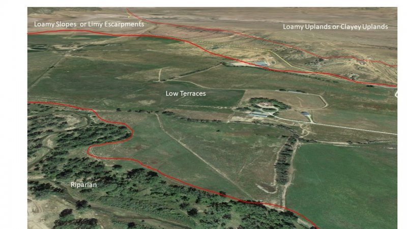
Ecological dynamics
Ecological Dynamics of the Site:
Plant tables have not been developed for this site. Until such time as they can be updated, use the plant tables in the referenced literature that correlates to this concept (refer to Other Information within the Interpretations section, and to Legacy Site Information below in this narrative). With respect to the imperfect alignment of such correlations, be aware of these shortcomings in their applicability to conservation planning.
Early work by Kuchler (1964) identified the potential natural vegetation type for the Canadian Plateaus LRU as that of the grama/buffalograss short grass prairie. The Low Terraces ecological site is dominated by short grasses, but also contains a mix of shrubs, forbs, and succulents. As is typical of plant communities, pronounced annual variations in precipitation translate to considerable short-term fluctuations in annual production within a given plant community phase.
There are numerous variables which affect the range of characteristics for this ecological site. Variables such as elevation, latitude, and orographic effects create a climatic gradient which influence the distribution of C3 and C4 plants. Soil properties such as surface texture, depth to clay layer, parent material, and accumulated salts affect species diversity and composition. Natural disturbances such as drought and wildfire affect species density and cover.
The climate gradient across the CP LRU shows a greater distribution of C3 plants such as western wheatgrass and bottlebrush squirreltail where temperatures are cooler, and moisture is more abundant. Where surface texture trends toward clay loam, western wheatgrass, galleta, and vine mesquite grass increase. Where the plateau bedrock is Cretaceous shale and the site trends toward a surface texture of clay loam with an increase in salt in the profile, alkali sacaton and four-wing saltbush increase. Refer to Appendix C to see scientific names and plant codes alongside common names.
Fire is a disturbance regime that reduces succulents and shrubs while stimulating grasses and forbs. Not all fires are equal. According to Gebow (2001), fire effects in the same location will vary, especially with fire timing, both seasonally and within the scheme of year-to-year moisture variation. Precipitation during seasons before and after fire has a major effect on recovery of plants. Fire promotes rhizomatous plant species, such as western wheatgrass, that can take advantage of below-ground rhizomes from which tillering is rapidly initiated.
Correlation to Current Ecological Sites:
Bottomland- R070AY004NM: This site was written for drainageways, alluvial fans, and floodplains, none of which are affected by stream hydrology. The soil systems that are impacted by stream hydrology are significantly different, and yet ecologically important enough from these other types of bottomland soils to differentiate into a separate site.
Loamy Upland- R070AY001NM: This site is not specific to stream terraces and thus does not take into account the soil morphology or hydrology of these specific types of ecology. Thus, while the Loamy Upland ecological site has been applied to areas that currently correlate to Low Terraces, the former is a poor fit for these areas.
Most components of the Low Terraces ecological site are currently tied to the Bottomland ecological site (R070AY004NM). The bottomland site was established for all broad drainageways, floodplains, and alluvial fans. In addition, the Bottomland ecological sites are described as “not influenced by water from a stream”.
Historic Climax Plant Community:
Grasses dominate this site. Mid-grasses such as western wheatgrass, alkali sacaton, and sideoats grama are dominant with a variety of short grasses. Forbs and shrubs are only a minor portion of the plant community. This site occurs in elongated drainages that transport surface runoff from adjoining upland sites and swales. Because of the extra water received by this site, the grass is denser, stands higher and is one of the most productive sites in the resource area.
Grazing:
This site can be grazed any season of the year by all classes and kinds of livestock. Because of the forage produced by alkali sacaton, cattle and horses may best be suited. Continuous grazing during the growing season will cause the more desirable forage plants such as western wheatgrass, vine-mesquite, sideoats grama, Canada wildrye, and fourwing saltbush to decrease. Species most likely to invade this site are buffalograss, ring muhly, cholla cactus, plains pricklypear, and rubber rabbitbrush. Species most likely to increase are blue grama, galleta, alkali sacaton, and desert saltgrass. As the ecological condition deteriorates, it is accompanied by a loss of vegetative cover causing channeling of the water, and the productivity is greatly reduced. The plant community may be dominated either by blue grama/galleta or alkali sacaton/galleta as deterioration advances. Where alkali sacaton dominates the site, livestock should be concentrated into small pastures to fully utilize the forage. Livestock should be rotated in the summer or pasture should be rested in alternate years. A system of deferred grazing, which varies the time of grazing and rest in a pasture during successive years, is needed to maintain or improve the plant community. Spring deferment is beneficial to western wheatgrass and allows alkali sacaton sufficient time to green up.
Tables from Bottomland ecological site (R070AY004NM)
Annual production by plant type
Plant Type----------Low(Lb/Acre) ----------Representative Value(Lb/Acre) ----------High(Lb/Acre)
Grass/Grasslike----------880----------------------------------2200----------------------------------3520
Forb-------------------------80------------------------------------200------------------------------------320
Shrub/Vine----------------30-------------------------------------75------------------------------------120
Total------------------------990----------------------------------2475---------------------------------3960
Community 1.1 plant community composition
Common Name----------------Symbol----------Scientific Name----------Annual Production (Lb/Acre)
GRASS/GRASSLIKE
1 alkali sacaton-------------------SPAI----------Sporobolus airoides----------625–750
2 western wheatgrass----------PASM--------Pascopyrum smithii-----------500–625
3 vine mesquite------------------PAOB--------Panicum obtusum-------------500–625
4 blue grama---------------------BOGR2-------Bouteloua gracilis--------------375–500
5 James' galleta-----------------PLJA-----------Pleuraphis jamesii-------------250–375
6 sideoats grama---------------BOCU---------Bouteloua curtipendula-------250–375
7 silver bluestem---------------BOSA----------Bothriochloa saccharoide----25–125
8 cane bluestem---------------BOBA3---------Bothriochloa barbinodis------25–125
9 saltgrass-----------------------DISP------------Distichlis spicata----------------25–125
10 Canada wildrye------------ELCA4----------Elymus canadensis--------------25–125
11 Graminoid (grass or grass-like)-2GRAM-Graminoid (grass or grass-like)-25–125
FORB
12 globemallow----------------SPHAE----------Sphaeralcea---------------------25–125
13 Cuman ragweed------------AMPS----------Ambrosia psilostachya--------25–125
14 upright prairie coneflower-RACO3-------Ratibida columnifera----------25–125
15 Forb, perennial--------------2FP-------------Forb, perennial-----------------25–125
16 Forb, annual-----------------2FA-------------Forb, annual--------------------25–125
SHRUB/VINE
17 fourwing saltbush---------ATCA2----------Atriplex canescens-------------0–125
18 Apache plume-------------FAPA----------Fallugia paradoxa---------------0–125
19 Shrub, deciduous---------2SD------------Shrub, deciduous---------------25–125
--------------------------------------------------------------------------------------------------------------------
Components tied to the Loamy Upland ecological site (R070AY001NM).
Historic Climax Plant Community:
This site is a grassland characterized by mid and short-grasses. Blue grama is the dominant warm-season species. Western wheatgrass is the dominant cool-season species.
Grazing:
This site can be used by all classes of livestock during any season of the year. Because of the occasional severe winter storms, emergency feed may be necessary. Yearling calves grazing from May to October may be favored because of these winter storms. Approximately 90 percent of the total yield is from species that furnish forage for grazing. Continuous grazing during the growing season will cause the more desirable forage plants such as western wheatgrass, bottlebrush squirreltail, galleta, sideoats grama, and winterfat to decrease. Species most likely to increase are blue grama, ring muhly and buffalograss. As the ecological condition deteriorates, it is accompanied by a sharp increase of blue grama. Continuous heavy grazing will cause blue grama to form a low, dense turf, which is low in productivity. A system of deferred grazing, which varies the time of grazing and rest in the pastures during successive years in needed to maintain or improve the plant community. Grazing western wheatgrass during the months of May and June will cause a sharp decrease; therefore, rest during this period will allow western wheatgrass to grow and reproduce.
Tables from Loamy Upland ecological site (R070AY001NM):
Annual production by plant type
Plant Type-------Low(Lb/Acre) -------RV(Lb/Acre)-------High(Lb/Acre)
Grass/Grasslike -------610--------------860---------------------1100
Forb---------------------130--------------130---------------------140
Shrub/Vine------------130--------------130---------------------130
Total---------------------870--------------1120-------------------1370
Community 1.1 plant community composition
Common Name--------------Symbol-------Scientific Name-------Annual Production (Lb/Acre)
GRASS/GRASSLIKE
1-------blue grama--------------BOGR2-------Bouteloua gracilis---------312–357
2-------western wheatgrass-PASM--------Pascopyrum smithii-------178–223
3-------squirreltail----------------ELEL5--------Elymus elymoides---------89–133
4-------James' galleta-----------PLJA---------Pleuraphis jamesii----------43–89
5-------sideoats grama-----------BOCU-------Bouteloua curtipendula---43–89
6-------threeawn------------------ARIST---------Aristida-----------------------25–44
7-------ring muhly-----------------MUTO2------Muhlenbergia torreyi-----25–44
8-------buffalograss---------------BODA2------Bouteloua dactyloides-----25–44
9-------common wolfstail--------LYPH---------Lycurus phleoides-----------25–44
10-------sand dropseed-----------SPCR---------Sporobolus cryptandrus----25–44
FORB
12-------Forb, annual---------------2FA-------------Forb, annual------------------10–48
13-------Forb, perennial------------2FP-------------Forb, perennial---------------10–48
14-------Cuman ragweed----------AMPS---------Ambrosia psilostachya------10–25
15-------scurfpea--------------------CULLE---------Cullen-------------------------5–25
16-------prairie clover---------------DALEA---------Dalea---------------------------5–25
17-------dotted blazing star---------LIPU----------Liatris punctata--------------5–25
18-------locoweed--------------------OXYTR---------Oxytropis---------------------5–25
19-------upright prairie coneflower-RACO3------Ratibida columnifera-------5–25
20-------scarlet globemallow--------SPCO--------Sphaeralcea coccinea-------5–25
SHRUB/VINE
21-------winterfat---------------------KRLA2----------Krascheninnikovia lanata--29–48
22-------prairie sagewort-------------ARFR4-------Artemisia frigida-------------29–48
23-------Shrub, deciduous-------------2SD---------Shrub, deciduous-------------29–48
------------------------------------------------------------------------------------------------------------
From the San Miguel Soil Survey Manuscript (NM630), map unit Md-Manzano clay loam, 1 to 3 percent slopes
This unit is used for irrigated crops, mainly alfalfa, small grain, vegetables, and orchards. Among the other crops grown are corn, grain sorghum, and legumes. This unit is also used for livestock grazing and for wildlife habitat.
If this unit is used for irrigated crops, the main limitations are moderately slow permeability and moderate hazards of soil blowing and water erosion.
Furrow, border, corrugation, and sprinkler irrigation systems are suited to this unit. The method used generally is governed by the crop. Water should be applied in amounts sufficient to wet the root zone but in amounts small enough to minimize the leaching of plant nutrients. Soil blowing can be reduced by using all crop residue and practicing minimum tillage. Yield can be maintained or increased by applying fertilizer. Most crops, except for legumes, respond to nitrogen. Legumes respond to phosphate. Rotation grazing helps to maintain the quality and quantity of forage. Timely harvesting of crops improves their quality.
The potential plant community on the Manzano soil is mainly western wheatgrass, blue grama, alkali sacaton, and vine-mesquite. As the range deteriorates, the proportion of these forage plants decreases and the proportion of galleta, ring muhly, and broom snakeweed increases. Grazing management should be designed to increase the productivity and reproduction of western wheatgrass, blue grama, and buffalograss. Forage production is reduced in areas where gullies have formed. This unit is suited to such range improvement practices as mechanical treatment, earthen ponds, and seeding.
Adapted from the Rangeland Productivity table in the NM630 Manuscript
Manzano component of map unit Md (correlated here to the “Loamy” range site – not to be confused with R070AA001NM) -- The approximate species composition of the potential plant community is as follows:
Blue Grama-----------------------------------------------45
Western Wheatgrass-------------------------------------25
Galleta-----------------------------------------------------10
Buffalograss--------------------------------------------5
Mat muhly-------------------------------------------------5
Total production in pounds per acre for unfavorable, normal, and favorable years: 350, 800, and 1,450.
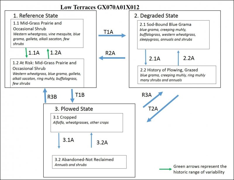
State 1
Reference State
This diagnostic reference state is characterized by a variety of mid- and short-prairie grasses such as western wheatgrass, blue grama, alkali sacaton, and vine mesquite with some lesser amounts of shrubs such as fringed sagebrush, fourwing saltbush, and forbs. When the site is stressed due to grazing or animal pressure, the proportion of these grasses decreases and the proportion of galleta, ring muhly, fringed sagebrush, and broom snakeweed increases along with annuals and weedy species such as field bindweed, Russian thistle, kochia, and scarlet globemallow.
Diversity of plant species and density of foliar and basal cover encourages the cycling of organic matter and therefore nutrients in what is functionally a positive feedback loop of fertility. In these conditions, infiltration is high, allowing more moisture to be absorbed and thus retained in the landscape, and which further encourages resilience to drought periods.
High amounts of vegetative canopy cover shades the ground, keeping it cooler, armored from rain-splash erosion, water erosion during overland flow events, and wind erosion. Long-term rates of erosion and organic matter cycling are in equilibrium and only fluctuate slightly year-to-year due to normal climatic variability. Fire is a natural cycle that also encourages recycling of nutrients and maintains a grass and forb advantage over shrub encroachment.
Community 1.1
Mid-Grass Prairie and Occasional Shrub
This reference plant phase has a presence of most of the grass species listed above. Though it likely had some history of crop agriculture, there has been sufficient time and consideration to recovery of a self-sustaining plant community dynamic. The recovery to reference conditions requires that the soil has a deep surface layer of high organic matter content which provides resilience to stressors such as plowing, overgrazing, or hydrologic impairment. In addition, the site retains its native seed bank, or is or in proximity to a seed source to resupply the plant community diversity.
This plant community phase has the highest species diversity which optimizes energy flow, hydrologic function, and nutrient cycling. The diverse root systems take advantage of moisture from both close to the surface as well as deep in the profile, thus maintaining organic matter within the soil in a larger range of depths. Decomposition is active, cycling the labile soil organic matter pools which enhances nutrient availability, and creating humus which adds to the retention of plant available nutrients and water needed for plant vigor.
A mix of grasses, forbs shrubs and possibly a few succulents are present. Total foliar cover is greater than 90 percent with less than 15 percent bare ground. Annual production ranges from 1000 pounds per acre in unfavorable years following a period of drought, or after a fire, to 3500 pounds per acre in favorable years when rainfall has been timely and plentiful.
Community 1.2
At Risk: Mid-Grass Prairie and Occasional Shrub
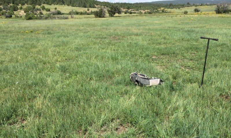
Figure 4. Community phase 1.2
This community phase is characterized by a mix of grasses, forbs, shrubs and possibly a few succulents. Total foliar cover is greater than 80 percent. Decreasers are reduced, possibly an absence of vine mesquite and fewer fourwing saltbush. However, it is still within the reference state, meaning it has not crossed a threshold, and that intensive management (i.e., accelerating practices) is not yet required to push the system back into the historic range of variability (Bestelmeyer, et al., 2010).
Pathway 1.1A
Community 1.1 to 1.2
This pathway represents a period of time following fires or drought, perhaps coupled with some minor grazing activity, either by wildlife and/or livestock.
Pathway 1.2A
Community 1.2 to 1.1
This pathway represents a longer period since drought, with maybe a favorable year or two in the recent past. It could also represent a rest period or significant decrease in grazing pressure in both frequency and intensity.
State 2
Degraded State
This plant community state exists after some period of plowing or extended periods of continuous grazing and favors increasers such as blue grama, which is commonly growing in its low productivity sod form. A noticeable increase in shrubs such as fringed sage and broom snakeweed and annuals such as scarlet globemallow, curlycup gumweed, and field bindweed has also occurred. The resulting increase in bare ground has allowed undesirable species to establish, with a higher amount of annuals. This causes a decrease in rooting density, especially the permanent rooting which leaves the topsoil more susceptible to erosion, both wind and water. It also decreases the amount of organic matter storage and cycling, which in turn limits annual nutrient cycling. The annuals and shrubs do, however, help to remediate any dense plow pans that have formed, helping to increase permeability and storage of moisture.
Community 2.1
Sod-Bound Blue Grama
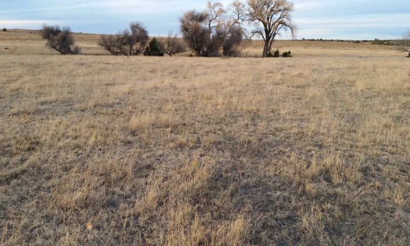
Figure 5. Community Phase 2.1 in San Miguel County, November 2017. Blue grama is in sod-bound habit. Cottonwood trees occupy a Riparian site in the background.
The plant community phase is typically recovering from a period of crop agriculture, with or without irrigation, and likely had been plowed for some period. Alternatively, it has experienced prolonged continuous grazing. The dominant grasses here are blue grama and western wheatgrass as low species diversity becomes characteristic. Vine mesquite becomes extirpated from the site while annuals and shrubs increase in coverage.
Total foliar cover is between 60 and 85 percent with low grass diversity and greater than 20 percent shrubs and annuals.
Community 2.2
History of Plowing, Grazed

Figure 6. Site on formerly cropped stream terrace along the Rio Mora. It is basically a sod-bound blue grama grassland with some mat muhly and about 20 percent bare ground. Note the fleabane daisy flowers.
This phase has been historically plowed, or is in close proximity to cropped fields as to have a compacted layer similar to a plow pan. This alters the permeability of the soil, encouraging more runoff during heavy rain events, whicht can lead to loss of topsoil.
Total foliar cover is between 50 and 80 percent, with low species diversity, and greater than 20 percent shrubs and annuals.
Pathway 2.1A
Community 2.1 to 2.2
History of Plowing, Grazed
This pathway represents an increase in the intensity and/or duration of grazing, coupled with periods of drought.
Pathway 2.2A
Community 2.2 to 2.1
History of Plowing, Grazed
This pathway represents an implementation of deferred grazing or rested periods so that species diversity and/or density can recover.
State 3
Cropland State
This state exists in areas with histories of plowing and cropping. A plowpan (compacted zone) is usually present within the upper 10 inches (25 centimeters) of the soil profile. Thickness of topsoil and the concentration of organic matter therein is often diminished.
Characteristics and indicators. A plowpan (compacted zone) is usually present within the upper 10 inches (25 centimeters) of the soil profile. Thickness of topsoil and the concentration of organic matter therein is often diminished. Plant species are quite variable--consisting of either crops or early-seral species, depending on whether the site is actively cultivated.
Community 3.1
Cropped
This plant phase exists where the terraces are currently cropped. With the exception of orchards, these areas are gennerally plowed at least once annually, and planted in a monoculture crop. The common crops grown in this area include mainly alfalfa, small grain, vegetables, and tree orchards. At a given time, the field may be 100 percent bare ground or 100 percent covered by crop foliage.
Community 3.2
Post-Cropped
When a field that has been plowed for decades is abandoned and not reclaimed, it has lost all of its seed bank and will recover in weedy species with few native grasses. Foliar cover may vary from 20 to 80 percent.
Pathway 3.1A
Community 3.1 to 3.2
Abandonment of the field without having attempted to restore it to some semblance of a historic plant community through seeding practices or an irrigation plan.
Pathway 3.2A
Community 3.2 to 3.1
Return of irrigation and regular cropping cycle. Perhaps limited till or no till.
Transition T1A
State 1 to 2
Season-long grazing providing little rest and recovery for preferred grazed plants during critical growing periods, coupled with high utilization, and followed by a single drought event, can cause a state shift to the degraded condition. Selective grazing pressure on palatable species such as western wheatgrass, alkali sacaton, and vine mesquite leads to a decrease in the vigor and abundance of these species, and advantages less-palatable species such as galleta, fringed sage, and broom snakeweed. Accelerated erosion depletes soil organic matter and reduces the seedbank.
Constraints to recovery. The persistence of a continuous grazing regime and/or unfavorable weather patterns (i.e. drought).
Transition T1B
State 1 to 3
Plowing and cropping of the terraces, typically with a monoculture of alfalfa, hay, wheat, or perhaps corn or beans.
Constraints to recovery. Loss of soil organic matter and seedbank, as well as the establishment of infrastructure such as roads and ditches.
Restoration pathway R2A
State 2 to 1
Changing management strategies to favor native plant diversity and production, via deferred grazing with periods of rest, especially during droughts. Restoration through seeding practices may be necessary to reestablish the desired plant community diversity. If reseeding is to be successful, an irrigation plan for a period of several seasons may be required to ensure plants germinate and establish to prevent recidivism back to its degraded state. The site may require gully restoration activities such as installation of small rock grade control structures, or other engineered methods designed for the specific site and issues. In addition, some consideration for the condition of adjacent sites with respect to concentrating runoff waters or proximity to weed sources may be prudent for long term success.
Context dependence. Specific practices required will depend on which desired species remain in the seedbank, on weather conditions, and on the presence/abundance of gullies.
| Range Planting |
|
| Improved Water Application |
|
| Prescribed Grazing |
|
| Grazing Management Plan - Applied |
|
| Intensive rotational grazing |
|
Transition T2A
State 2 to 3
Conversion of the terraces from a naturally vegetated rangeland condition to a planted crop of alfalfa, hay, wheat, or perhaps corn or beans. The process requires plowing, which has the effect of disturbing natural soil structure, thereby exposing the topsoil to enhanced decomposition which burns off the native soil organic matter content and releases carbon dioxide to the atmosphere. These practices are shown to reduce the total amounts of soil organic carbon and soil organic nitrogen (Wilfred and Mann, 2005; Miller et al., 2004). It also exposes bare soil to water and wind erosion and an intense period of moisture loss from the soil. This process can be minimized by adopting no till or low till (conservation tillage) practices that limit the amount of damage to soil health by conventional tilling practices.
Restoration pathway R3B
State 3 to 1
Intensive restoration beginning with a seeding practice utilizing a historic native plant mix that aims to break up the plow pan with a mix of deep rooting annuals and shrubs. If reseeding is to be successful, an irrigation plan for a period of several seasons will be required to ensure plants germinate and establish to prevent a return to a degraded state. Several years to decades of close management following conversion of cropped fields to a native grassland state may be required to restore the topsoil organic matter content to a level that sustains natural organic matter cycling processes. In addition, some remediation of roads and other farming infrastructure will help prevent other sources of erosion or weed establishment.
Context dependence. Whether or not this restoration pathway is practical remains to be seen. Practices required will depend on dynamic soil properties, and on the presence of infrastructure.
Restoration pathway R3A
State 3 to 2
Restoration through seeding practices may be necessary to reestablish the desired plant community diversity. If reseeding is to be successful, an irrigation plan for a period of several seasons may be required to ensure plants germinate and establish to prevent a return back to a degraded state. Several years to decades of close management following conversion of cropped fields to a native grassland state may be required to restore the topsoil organic matter content to a level that sustains natural organic matter cycling processes. In addition, some remediation of roads and other farming infrastructure will help prevent other sources of erosion or weed establishment.
Context dependence. Required practices will depend on dynamic soil properties prior to restoration, and on the presence of infrastructure.


