Ecological dynamics
Plant tables have not yet been developed for this site. Until such time as they can be updated, use the plant tables in the referenced in legacy literature that correlates to this concept. With respect to the imperfect alignment of such correlations, be aware of these shortcomings in their applicability to conservation planning.
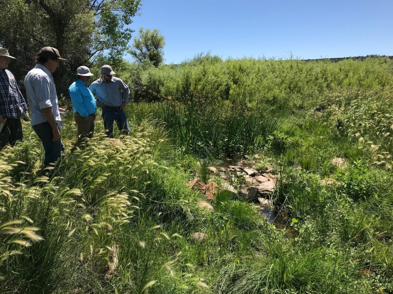
Riparian systems are the most ecologically dynamic in a given landscape, capable of dramatic changes in brief timescales to the soil properties, biological composition, as well as hydrology and water table. There are no developed legacy ecological site concepts to reference, however, we have included the plant tables from the Bottomland site that has been correlated in the past to riparian landform positions. Be extremely cautious before using any legacy information as an analog for riparian sites.
Correlation to Current Ecological Sites:
Bottomland- R070AY004NM: This site was written for drainageways, alluvial fans, and floodplains, none of which are affected by stream hydrology. We consider the soil systems that are impacted by stream hydrology to be significantly different, and yet ecologically important enough from these other types of bottomland soils to differentiate into a separate site.
Riverine Riparian- F070AY023NM: This site does not have a developed concept but would otherwise have most likely correlated closest to the Riparian ecological site.
Tables from Bottomland (R070AY004NM)
Annual production by plant type
Plant Type----------Low(Lb/Acre) ----------Representative Value(Lb/Acre) ----------High(Lb/Acre)
Grass/Grasslike----------880----------------------------------2200----------------------------------3520
Forb---------------------------80------------------------------------200------------------------------------320
Shrub/Vine----------------30-------------------------------------75------------------------------------120
Total-------------------------990-----------------------------------2475---------------------------------3960
Community 1.1 plant community composition
Common Name----------------Symbol----------Scientific Name----------Annual Production (Lb/Acre)
GRASS/GRASSLIKE
1 alkali sacaton-------------------SPAI----------Sporobolus airoides------------625–750
2 western wheatgrass----------PASM--------Pascopyrum smithii-----------500–625
3 vine mesquite------------------PAOB--------Panicum obtusum---------------500–625
4 blue grama---------------------BOGR2-------Bouteloua gracilis---------------375–500
5 James' galleta-----------------PLJA-----------Pleuraphis jamesii-------------250–375
6 sideoats grama---------------BOCU---------Bouteloua curtipendula-------250–375
7 silver bluestem---------------BOSA----------Bothriochloa saccharoide----25–125
8 cane bluestem---------------BOBA3---------Bothriochloa barbinodis------25–125
9 saltgrass-----------------------DISP------------Distichlis spicata-----------------25–125
10 Canada wildrye------------ELCA4----------Elymus canadensis--------------25–125
11 Graminoid (grass or grass-like)-2GRAM-Graminoid (grass or grass-like)-25–125
FORB
12 globemallow----------------SPHAE----------Sphaeralcea---------------------25–125
13 Cuman ragweed-----------AMPS----------Ambrosia psilostachya--------25–125
14 upright prairie coneflower-RACO3-------Ratibida columnifera----------25–125
15 Forb, perennial--------------2FP-------------Forb, perennial-------------------25–125
16 Forb, annual-----------------2FA-------------Forb, annual----------------------25–125
SHRUB/VINE
17 fourwing saltbush-------ATCA2----------Atriplex canescens-------------0–125
18 Apache plume-------------FAPA----------Fallugia paradoxa----------------0–125
19 Shrub, deciduous---------2SD------------Shrub, deciduous---------------25–125
State 1
Reference State
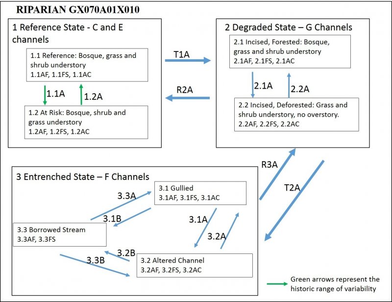
This represents the most late-seral state observed during ESD development, and does not necessarily reflect all Pre-Columbian plant communities. It assumes a dynamic system with regular periods of flooding associated with sediment transport and deposition that result in channel migration within its meandering active floodplain. The presence or absence of beaver plays a role in retention of sediment and thus retention or storage of water in the landscape that modulates peak flow and helps to maintain a more consistent baseflow.
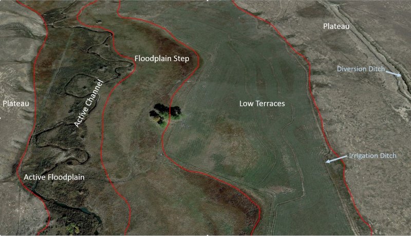
Active Floodplain (AF) - The active floodplain has the typical components of a meandering river channel; the point bar and cut-banks. These are dynamic landforms that may change position over time as the channel migrates naturally. The channel regularly accesses the active floodplain as water levels fluctuate with normal stream stage. These sediments are usually within a meter or less to the water table and seasonally are inundated.
The substrate associated with these features will consist of recent deposited stratified materials that form soils such as Ustifluvents or Haplustolls. Hydric soil components are present as wetlands in these landforms where old cutoff channels form swales in the cutbank floodplain, or where water stagnates along the point bar. The latter condition is more common along downstream portions of the point bar, backwater swales, or where materials are less sandy and gravelly. Hydric soils make up 15 to 45 percent of this component.
Stream channels are of the C and E types which are described as highly sinuous and meandering, low gradient, stable, lower width to depth ratios and with broader connected floodplains.
Floodplain Step (FS) - The higher position floodplain step will still receive overbank flooding on a regular basis, but may only occur during extreme events, perhaps 10-year or 20-year cycles. These positions are characterized by loamier materials that exist in lower energy overbank waters and rarely have fragments within a meter of the soil surface. In the Reference State, flooding will occur seasonally or every few years during high stream stages resulting in erosion or aggradation of their margins during these events. The channel water has regular access to the floodplain during flood events which acts to disperse the energy across a greater surface area.
Diversity of plant species and density of foliar and basal cover encourages the cycling of organic matter and therefore nutrients. Infiltration is high, allowing more moisture to be retained in the landscape, and which encourages resilience to drought periods. Good canopy cover shades the ground, keeping it cooler, and armored from rain-splash erosion and during periods of flooding. Rates of organic matter cycling and storage are in long-term equilibrium and only fluctuate slightly with annual variation in climate and major flooding events. Fire is a natural cycle that also encourages recycling of nutrients and maintains a grass and forb advantage over shrub encroachment.
Active Channel (AC) - The active channel course is not characterized by a soil profile, but is usually composed of interbedded gravels and sands with some areas of siltier deposits. During high flow stages, there may be some inundation of the point bar which results in a temporary subaqueous soil with emergent wetland vegetation. Channel stream shapes are best characterized by the Rosgen cross-section configurations C and E. Entrenchment ratios are relatively high, meaning the width of the floodplain accessed by an overbank event is at least twice the width of the channel at bank-full conditions. In addition, higher sinuosity and lower stream gradient are characteristic of these stream channel types.
Community 1.1
Diagnostic Plant Community
This site includes the active channel, active floodplain, and floodplain step. Bosque with grass and shrub understory. Total foliar cover is around 95 percent.
Active Floodplain – The plant communities found on the point bar and cut banks are characterized by willows and cottonwoods with some box elder and should have a variety of shrub species such as wild rose, fourwing saltbush, skunkbush sumac, and Apache plume, and grass or graminoid species such as sedges, rushes, Canada wildrye, redtop, threesquare, and horsetail in locations with shallow water tables. In drier spots, western wheatgrass, buffalograss, and alkali sacaton are common grasses, along with giant sacaton, inland saltgrass, and vine mesquite with sand dropseed in sandier locations. Plant canopies are near 100 percent with little to no bare ground, and leaf and small woody litter as well as larger snags making up at least 30 percent of the ground cover. Beaver may be part of this ecosystem and are a good sign of a functioning riparian corridor. Multiple plant structures are present, with tree canopies consisting of mostly cottonwoods, scattered patches of willow, a mid-canopy of fourwing saltbush, skunkbush sumac, wild rose and other shrubs, and an understory with a large diversity of grasses, forbs, and graminoids.
Floodplain Step - The plant community will be characterized by a typical bosque forest dominated by cottonwood species with possible stratified understory of shrubs such as Apache plume, fourwing saltbush, and wild rose; grasses such as western wheatgrass, buffalograss, alkali sacaton, brome, lovegrass, vine mesquite, inland saltgrass and sand dropseed; with a variety of annuals and forbs. Plant canopies are near 100 percent with little to no bare ground, and leaf and small woody litter as well as larger snags making up at least 30 percent of the ground cover.
Active Channel: – 60 to 90 percent of stream channel is shaded by overstory, variety of emergent species along banks, connected to active floodplain by small channel step somewhere between 8 to 20 inches, depending on stream stage.
Dominant plant species
-
cottonwood (Populus), tree
-
willow (Salix), tree
-
Woods' rose (Rosa woodsii), shrub
-
fourwing saltbush (Atriplex canescens), shrub
-
skunkbush sumac (Rhus trilobata), shrub
-
Apache plume (Fallugia paradoxa), shrub
-
sedge (Carex), grass
-
rush (Juncus), grass
-
Canada wildrye (Elymus canadensis), grass
-
western wheatgrass (Pascopyrum smithii), grass
-
alkali sacaton (Sporobolus airoides), grass
-
vine mesquite (Panicum obtusum), grass
Community 1.2
At Risk: Bosque shrub and grass
A reduction in grasses, especially species that decrease due to grazing.
Active Floodplain – In comparison to 1.1AF, this community will exhibit a lower diversity of grasses and some decreases in other plant types that provide desirable forage. A slight increase in presence of shrubs will occur, and should reflect the intensity and frequency of grazing. Areas of bare ground may be more prevalent as well as some loss of multi-stage canopy.
Floodplain Step – A decrease in grass species diversity with an associated increase in shrubs and forbs, which should reflect the intensity and frequency of grazing.
Active Channel - 40 to 75 percent of channel shaded by overstory, a few emergent species growing along the channel banks, connected to active floodplain by channel step ranging from 20 to 39 inches, depending on stream stage.
Pathway P1.1A
Community 1.1 to 1.2
Represents a decrease of understory plants, primarily grass species diversity such as western wheatgrass and vine mesquite, due to grazing pressure. Possibly some shrubs are decreased as well, such as fourwing saltbush. Also possible is a conversion of the adjacent watershed to a degraded condition that may increase bareground, thereby increasing runoff and erosion and decreasing infiltration. This may adversely affect seasonal groundwater supply in the bottomlands and floodplains.
Pathway P1.2A
Community 1.2 to 1.1
Deferred grazing program will help restore range health by increasing the diversity of plant species and decreasing bare ground. A strong emphasis on managed livestock with dormant season grazing, pasture rotation, and periods of rest.
State 2
Degraded State – G Channels
Channel has been confined, straightened or watershed hydrology altered in terms of flooding frequency so that channel becomes incised or entrenched. This is a result of diverted waters for irrigation purposes or installation of flood control and water storage structures upstream that negatively impact seasonal baseflow and flooding events. As a result, the water table drops and bank storage decreases.
Some other scattered encroachment or connection to road crossings, diversion ditches, or other structures along and into the riparian zone. It is likely that the stream terraces connected to these riparian zones have been utilized for crop production which involves plowing, irrigation, drainage systems, as well as some access roads. Grazing of livestock is common within and along the corridor, without seasonal deferral or grazing plan designed to benefit riparian ecology. This may result in decreased flow, lower sinuosity, increased slope or stream velocity, and typically a lower entrenchment ratio.
These hydrologic shifts result in a deterioration of environmental services such as: lowered baseflow of stream during dry periods, increased severity of drought periods, increased erosion of stream banks and associated formation of lateral gullies, and loss of wetland acreage.
Loss of wetlands reduces ecological services such as: storage of organic matter in the soils which provide increased water holding capacity and nutrient retention; scrubbing pollutants from upland waters before reaching the stream through denitrification of organic N (reduced to gaseous N compounds such as N2); providing habitat for rare hydrophytic plants that tend to be good forage for wildlife and livestock and habitat for rare and endangered species.
The change in water table height may cause a shift or reduction in riparian habitat along the banks, plants such as willows may struggle to exist. In these situations, the banks may become un-vegetated or under-vegetated in some areas and susceptible to erosion during flood events. This destabilization of channel banks will release sediments that will not only increase turbidity in the water, and silt up downstream water storage structures, but it will cause a change in the channel/floodplain dynamics such as width to depth ratios or entrenchment ratios.
Active Floodplain (AF) - Often a decrease of willow species occurs with an increase in blue grama, smooth brome, inland saltgrass and annuals such as bindweed, lambsquarters, and kochia. Encroachment of exotic species such as salt cedar and Russian olive occurs, watch for presence of cocklebur as a sign of further degradation. Associated resources are compromised relative to the reference state which include a decrease in functioning wetland acreage and a decrease in infiltration and storage of groundwater. The hydric soils are only a fraction of their historic size, ranging from 5 to 20 percent of the component. Hydric soils are constrained as smaller narrow wetlands along margins of point bars, depressions from old oxbow cutoffs, or very narrow micro floodplains along entrenched channel while stream stage is low.
Loss of tree cover due to removal of bosque for wood products, or to increase understory production. It is also possible that the tree community has disappeared over time due to lowering of water table from altered flow and diversions upstream. Recruiting and regeneration has been unsuccessful over time, resulting in total loss of bosque ecosystem.
Floodplain Step (FS) – Optimized for access to pasture grazing, often roads or other disturbances or cropland are along edge or within this area.
Active Channel (AC) – Associated with managed-altered riparian system, the channel will respond with a greater width to depth ratio due to erosion of the banks and deposition of sediment in the channel. This, in addition to loss of bosque structure and willows along the banks will increase the temperature of the stream water which adds stress to some native aquatic populations.
Community 2.1
Incised, Forested; Bosque, Grass and Shrub Understory
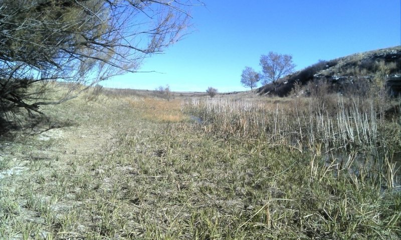
Figure 8. Active channel (2.1AC). Destabilization of the banks has widened the channel causing a high width to depth ratio, which is an unstable parameter for resisting further erosion during flood events.
2.1FS - Typically left high and dry, now functions more as a stream terrace. Can still flood under most extreme events, maybe 50 year floods. This landform has likely been plowed and planted in crops at some point historically. Adjacent stream terraces are likely still managed as irrigated cropland. There is a loss of bosque structure in this area. Tree species such as cottonwoods and willows are present but struggle to regenerate, most living trees are older than 30 years. Some increase in juniper species. Understory has a predominance of blue grama, western wheatgrass, and some lovegrass with an increase in sand dropseed, sleepygrass and even ring muhly with an increase in various annuals. Overbank flood events rarely access this floodplain.
2.1AC Entrenched channel, rarely interacts with floodplains, native wildlife struggles for habitat. Some parts of the channel may shift from E or C type channels to F type channels due to increasing width to depth ratios common of channel entrenchment in erodible parent materials. These channel types are characterized by higher, unstable bank erosion rates.
2.1AF - Channel incision causes lowering of channel with respect to floodplains and therefore detachment of local hydrology. Overbank events are less frequent, maybe once every few years. Sediments are less likely to be transported and redeposited, channel no longer migrates, cannot avulse. Loss of functioning hydric soil and therefore wetland acreage.
Dominant plant species
-
cottonwood (Populus), tree
-
willow (Salix), tree
Community 2.2
Incised, Deforested: Grass and Shrub Understory, No Overstory.
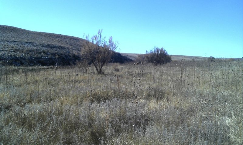
Figure 9. Typical Riparian ecological site on a floodplain (2.2AF) on what used to be the active floodplain, prior to entrenchment of the stream channel, but is now the floodplain step.
2.2FS –The resulting plant community tends to favor upland plants. In addition, typical understory plants that benefit from some shading will be outcompeted by upland plants that benefit from extra sun exposure and higher temperatures.
2.2AC The decreased canopy shading will increase the solar insolation on any streamflow waters and help to raise water temperatures. This has an impact on aquatic wildlife and on some emergent and aquatic vegetation.
2.2AF - The resulting plant community tends to increase upland plants. In addition, typical understory plants that benefit from some shading will be outcompeted by upland plants that benefit from extra sun exposure and higher temperatures. Shrubs may also increase.
Pathway P2.1A
Community 2.1 to 2.2
Incised, Forested; Bosque, Grass and Shrub Understory
Incised, Deforested: Grass and Shrub Understory, No Overstory.
After a considerable period in which water table is too low to allow establishment of trees, the overstory disappears as old trees die.
Pathway P2.2A
Community 2.2 to 2.1
Incised, Deforested: Grass and Shrub Understory, No Overstory.
Incised, Forested; Bosque, Grass and Shrub Understory
Reconnection of the water table to the floodplains sufficient to allow successful revegetation of cottonwoods and other tree species to occur through natural processes (long-term) or planting programs (short-term).
State 3
Heavily Impacted and Entrenched State – F Channels
Active Floodplains (AF) – Highly impacted by engineered channeling, near transportation corridors, highly diverted water from channel into irrigation structures characterize the geomorphic changes to this riparian zone. Bank-full flood stages rarely access this floodplain due to significant entrenchment of channel. Some widely scattered cottonwoods and willows but significant exotic woody species will have encroached in wetter areas, and mostly shrubs and upland grasses or forbs in drier areas.
Formerly incised channels have eroded the banks and increased the width to depth ratio in return. A new miniature floodplain system may have developed in this widened bottom, a small fraction of the former riparian corridor.
The water table may still be seasonally accessible due to discharge of upland landscape moisture during normal or wetter years, but can be absent on drier years. This will prevent willows from growing here, but not other upland shrubs such as fourwing saltbush and Apache plume.
Floodplain Step (FS) –Characterized by upland plant communities due to history of plowing for crops or for pasture grazing, with an increase in bare ground and annuals. Bank-full flood stages never access this floodplain, it’s essentially abandoned and acts as a stream terrace, absent a restoration plan to reconnect the hydrology. Arguably the historic active floodplain is now the floodplain step, but is limited in acreage in comparison.
Soils will likely be excessively drained since they commonly have subsurface horizons that are a minimum sandy but usually gravelly or cobbly textures. They act to further drain the upland hydrology more efficiently than historic catena functions. Storage of organic matter in the soils has declined due to erosion and/or the change from a high species diversity with canopy of 80 to 100 percent cover to a low diversity with a canopy ranging from 50 to 100 percent cover. Production has declined due to less consistent access to soil moisture from a seasonally fluctuating water table to a rarely accessible water table.
Active Channel (AC) – Entrenched or seasonally dry due to diverted stream waters. Stream channel type G with low entrenchment ratios and width to depth ratios, increased stream slope and bank erosion rates.
Community 3.1
Gullied
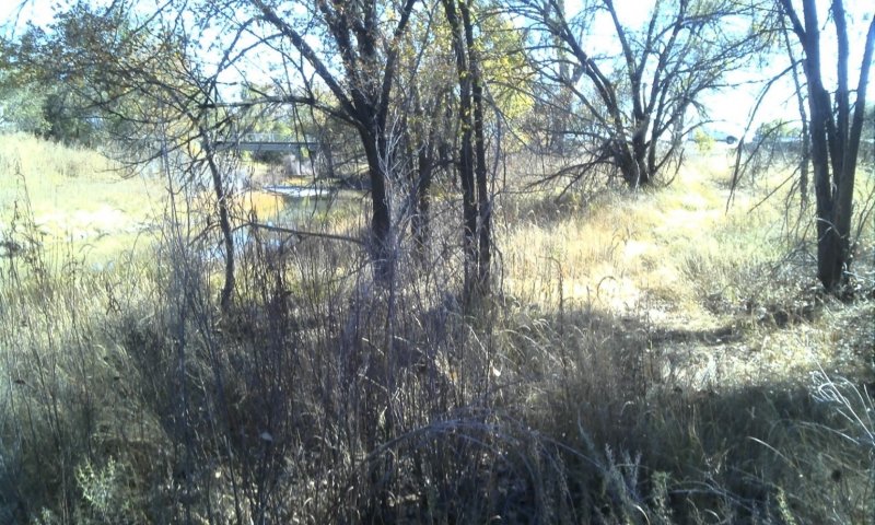
Figure 10. An abandoned floodplain of the Cimarron River (3.1AF) in an urban area of the town of Springer. The channel is now entrenched about 7 feet below this floodplain.
3.1AF – Gullied - Only small patches and narrow strips of floodplain along incised channel remain active and receive annual flooding events. Areas of former historic active floodplain are now elevated from current channel and act as the current functioning floodplain step. Willows replaced by Russian olive and salt cedar. Sedges, horsetail, and rushes are found here as well.
3.1FS – Gullied - Cottonwoods may still be present but failing to regenerate. In their place, exotics such as salt cedar, Russian olive, and Siberian elm trees may comprise the overstory canopy. Other understory plants that encroach or increase in this state include smooth brome, foxtail barley, cocklebur, Kentucky bluegrass, and prairie sagewort.
3.1AC – Gullied - Highly eroding channel, with unstable banks and multiple gullies cutting back into channel banks. Possibly 3 to 10 feet relief from channel to floodplain.
Community 3.2
Altered Channel
3.2AF – Altered Channel – the former active floodplain is now elevated well above any seasonal flooding zone. It will be dominated by upland plants and may possibly be invaded by exotic species. Where tree canopy still exists, a wider diversity of understory species will occur. However, the canopy may be dominated by exotic woody species such as Siberian elm or saltcedar. Where there is no remaining overstory canopy, only limited upland plan communities will occur.
3.2FS – Altered channel – Typically the forested canopy has been removed, and possibly replaced by exotic species such as mentioned in 3.1FS. The understory plant community is mostly upland plants dominated by annuals and shrubs.
3.2AC Altered Channel - Channel engineered via straightening or impoundment, or other structures. Highly managed channel will have low sinuosity and high gradient relative to its historic condition. It is confined and unlikely to have dynamic properties except for rare flooding events that are likely to cause damage to infrastructure.
Community 3.3
Borrowed Stream
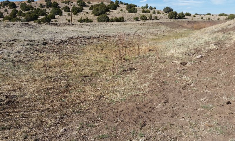
Figure 11. 7 An example of a dried out borrowed stream (3.3AF and 3.3FS) where decades of water diversion and groundwater withdrawal in the area have left this stream dry.
3.3AF -- Borrowed Stream - Where the historic waters of the stream have been either diverted into irrigation networks or pumped from groundwater tables for irrigation, municipal, or industrial uses, has rendered the stream ephemeral with irregular seasonal flow. The former channel is now the active floodplain. Wetter areas may have some hydrophytic species such as willows, rushes, and sedges. Drier locations, those on micro-highs or on small steps, have more upland plants such as western wheatgrass, blue grama and mat muhly. The woody overstory canopy is unlikely to occur but what remains may be dominated by exotic species.
3.3FS - Borrowed stream – The former floodplain now acts as a floodplain step or even a stream terrace with significant channel entrenchment ranging from 7 to 14 feet, and high relief due to major erosion of banks. Without restoration the flood stages may not access this landform every decade. It is common for this landform to have a dominance of annuals with greater than 50 percent bare ground.
Pathway P3.1A
Community 3.1 to 3.2
Alteration of a stream channel by straightening or restricting natural channel migration dynamics for the purpose of protecting infrastructure such as roads, buildings, or equipment.
Pathway P3.1B
Community 3.1 to 3.3
Alteration of natural and historic streamflow volumes due to diversion of waters away from the channel, or pumping from local water tables, for irrigation or municipal purposes, to the extent that surface flow is no longer perennial. In severe cases, diversion of streamflow causes the channel to be dry except for during flood events, similar to an ephemeral drainageway.
Pathway P3.2A
Community 3.2 to 3.1
To restore the natural sinuosity of a straightened or otherwise impaired channel, a comprehensive riparian restoration plan must be in place. The plan should include the removal of infrastructure or other assets along the floodplain such that the acreage can be re-designated as “land subject to natural dynamic processes”. This plan should have some temporal commitment and consider the long-term effects of this investment.
Pathway P3.2B
Community 3.2 to 3.3
Alteration of natural and historic streamflow volumes due to diversion of waters away from the channel, or pumping from local water tables, for irrigation or municipal purposes, to the extent that surface flow is no longer perennial. In severe cases, diversion of streamflow causes the channel to be dry except during flood events, similar to an ephemeral drainageway.
Pathway P
Community 3.3 to 3.1
Pathway P
Community 3.3 to 3.2
Transition T1A
State 1 to 2
Stream Corridor Degradation – Concentrated grazing for extended periods can lead to severe riparian degradation through loss of vegetative diversity, compaction, and trampling of streambanks. These processes can all lead to destabilization of the stream banks, accelerated erosion, and elevated instream sediment loads. This leads to a lowering of the stream channel through incision, effectively lowering the water table within the entire riparian zone, and detaching the vegetative communities from their historic sources of perennial moisture (Szaro 1989). In addition, diversion of upstream waters (acequias) can decrease the frequency and duration of flooding events, which in turn decreases the ability to maintain the water storage in the floodplains, and lowered water tables.
Restoration pathway R2A
State 2 to 1
Stream Restoration - Deferred grazing will help to restore plant community diversity and abundance, which should in turn help to stabilize some floodplain banks. Following changes in management, riparian restoration may be needed to increase sinuosity and reduce water velocity, which may induce deposition of sediment along point bars. Only then can there be a chance to reconnect the water table to the floodplain ecosystem and restore its historic ecological function. Reevaluation of stream water diversion systems may be necessary to achieve goals.
Context dependence. Annual and seasonal changes in stream flow tied to snowpack, other runoff variables such as storm intensities and frequencies can all be contributors or inhibitors to success in stream restoration activities. For instance, low spring runoff could cause upstream irrigation diversions to capture most if not all the surface flow in any given year. Water tables will also respond to such seasonal conditions, complicating vegetative response to riparian plantings. Restoration plans should include the possibility of delays due to these circumstances.
Transition T2A
State 2 to 3
Stream Corridor Gullying and Entrenchment – Severe diversion of stream water from channel for irrigation or municipal supplies will cause stream flow to decrease enough so that ecosystem no longer has access to historic moisture supply. Regeneration of cottonwoods and willows is no longer viable, possible exotic encroachment by tamarisk and Russian olive, and other upland species. Proximity of infrastructure such as roads, canals, railroad tracks, and other structures changes local hydrology to concentrate water in runoff events, and subsequently induce gullying on floodplains and stream banks.
Restoration pathway R3A
State 3 to 2
Riparian Restoration – Major changes to watershed management, diversion of irrigation water from channel, and relocation of infrastructure such as roads away from riparian corridors or rerouting bridges or low-water crossings to integrate better with stream function. Possible restoration activities may be needed to restore channel function such as inducing meanders via lateral controls: baffles, vanes, and other structures; as well as raising of channel depth via vertical controls: weirs, one-rock dams Zuni bowls etc.; (Zeedyke, 2009). Other more drastic measures may be needed to restore channel function.


