Natural Resources
Conservation Service
Ecological site R075XY083NE
Saline Depression
Last updated: 4/17/2025
Accessed: 12/07/2025
General information
Provisional. A provisional ecological site description has undergone quality control and quality assurance review. It contains a working state and transition model and enough information to identify the ecological site.

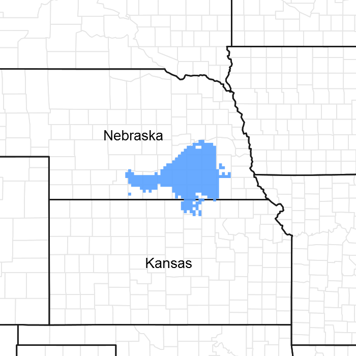
Figure 1. Mapped extent
Areas shown in blue indicate the maximum mapped extent of this ecological site. Other ecological sites likely occur within the highlighted areas. It is also possible for this ecological site to occur outside of highlighted areas if detailed soil survey has not been completed or recently updated.
MLRA notes
Major Land Resource Area (MLRA): 075X–Central Loess Plains
Named “The Central Loess Plains,” MLRA 75 is located primarily in south-central Nebraska, with about 10 percent lying in north-central Kansas. This approximately 5.3 million acre landscape covers all or parts of 21 counties: Gosper, Phelps, Kearney, Adams, Clay, Fillmore, York, Hall, Hamilton, Seward, Butler, Polk, Saline, Gage, Harlan, Franklin, Thayer, Nuckolls, and Webster in Nebraska, with a significant presence in Republic and Washington counties in Kansas. The northern border is defined by the Platte River. This MLRA is home to the unique ecological system called “The Rainwater Basin,” which is comprised of a 24,000 acre network of wetlands and uplands that occupy portions of 13 of the northern counties and is internationally known for its significance to millions of migratory birds.
The landscape primarily consists of gently rolling plains, with a number of narrow, shallow stream valleys. The river valleys are broader, and most feature a number of terraces. The elevation in MLRA 75 ranges from nearly 2,600 feet to less than 1,100 feet above sea level. The local relief averages from 10 to 25 feet but may stretch to a maximum of 165 feet in some areas. The average annual precipitation ranges from 23 to 36 inches, and the number of freeze-free days range from 150 to 200.
Loess overlays the surface of almost all of the uplands in this MLRA. Alluvial clay, silt, sand, and gravel are deposited in the stream and river valleys and can be extensive in the major drainages. Terraces are common in the valleys along the river systems. The predominant soil orders in this geographic area are mesic, ustic Mollisols, commonly represented by the Geary, Hastings, Holder, Holdrege, Kenesaw, and Uly soil series. The matrix vegetation type is mixed-grass prairie, with big and little bluestem, switchgrass, Indiangrass, and sideoats and blue grama to make up the bulk of the warm-season species, while western wheatgrass is the dominant cool-season grass.
Seventy two percent of the land in this MLRA has been broken out of native prairie and farmed; the land is primarily planted to corn, wheat, and grain sorghum, while only eighteen percent of the grasslands remain intact. Livestock grazing, primarily by cattle, is the main industry on these remnants. Irrigation of croplands uses over 90 percent of the total annual water withdrawal in this area.
Wildlife flourishes in this combination of crop and grassland environment, with both mule and white-tailed deer being the most abundant wild ungulates. A variety of smaller species, including coyote, raccoon, opossum, porcupines, muskrat, beaver, squirrel, and mink thrive in the region, as well as several upland bird species. Grassland bird populations are somewhat limited by the lack of contiguous native prairie and fragmented habitat created by the farmland. The rivers, streams, and lakes harbor excellent fisheries, and an estimated tens of millions of migrating and local waterfowl use the wetland complexes. These complexes provide ideal habitat for a number of wading and shore bird species as well.
This landscape serves as a backdrop for a disturbance-driven ecosystem, evolving under the influences of herbivory, fire, and variable climate. Historically, these processes created a heterogeneous mosaic of plant communities and structure heights across the region. Any given site in this landscape experienced fire every 6 to 8 years. The fires were caused by lightning strikes and also were set by native Americans, who used fire for warfare, signaling, and to refresh the native grasses. These people understood the value of fire as a tool, and that the highly palatable growth following a fire provided both excellent forage for their horses and attracted grazing game animals such as bison and elk.
Fragmentation of the native grasslands by conversion to cropland, transportation corridors, and other developments have effectively disrupted the natural fire regime of this ecosystem. This has allowed encroachment by native and introduced shrubs and trees into the remnants of the native prairie throughout the MLRA. Aggressive fire suppression policies have exacerbated this process to the point that shrub and tree encroachment is a major ecological issue in the majority of both native and reseeded grasslands.
Even as post-European settlement's alteration of the fire regime allows the expansion of the woody component of the native prairie, introduction of eastern redcedar (ERC) as a windbreak species further facilitates invasion by this species. While eastern red cedar is native to Nebraska, the historic population in MLRA 75 was limited to isolated pockets in rugged river drainages which were subsequently insulated from fire. Widespread plantings of windbreaks with eastern redcedar as a primary component have provided a seed source for the aggressive woody plant. The ensuing encroachment into the native grasslands degrades the native wildlife habit and causes significant forage loss for domestic livestock.
Since it is not a root sprouter, eastern red cedar is very susceptible to fire when under six feet tall. Management with prescribed fire is exceedingly effective if applied before this stage. Larger redcedars can also be controlled with fire, but successful application requires the use of specifically designed ignition and holding techniques.
Classification relationships
NRCS FOTG Section 1 - Nebraska Vegetation Zone 3.
Major Land Resource Area (MLRA): Major Land Resource Area (MLRA) 75 (USDA-Natural Resources Conservation Service, 2006)
Ecological site concept
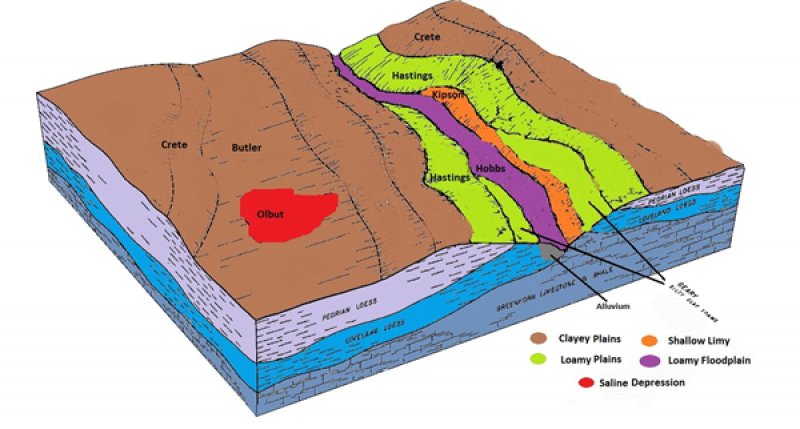
The Saline Depression is an upland run-on basin on the landscape, with no outlet. As the name implies, the soils associated with this site have high salinity. Surface salts are visible.
Associated sites
| R075XY057NE |
Clayey Plains This site is adjacent to the Saline Depression site but occupies a run-off position on the landscape. |
|---|---|
| R075XY058NE |
Loamy Plains This site may be adjacent to the Saline Depression site but occupies a run-off position on the landscape. |
Similar sites
| R075XY049NE |
Closed Upland Depression This site occurs on similar landscape position as the Saline Depression site but has no visible surface salts. |
|---|
Table 1. Dominant plant species
| Tree |
Not specified |
|---|---|
| Shrub |
Not specified |
| Herbaceous |
(1) Sporobolus airoides |
Click on box and path labels to scroll to the respective text.
