
Natural Resources
Conservation Service
Ecological site R081CY699TX
Clayey Bottomland 29-35" PZ
Last updated: 9/20/2019
Accessed: 11/21/2024
General information
Provisional. A provisional ecological site description has undergone quality control and quality assurance review. It contains a working state and transition model and enough information to identify the ecological site.
Associated sites
| R081CY355TX |
Adobe 29-35 PZ |
|---|---|
| R081CY360TX |
Low Stony Hill 29-35 PZ |
| R081CY574TX |
Shallow 29-35 PZ |
Similar sites
| R081CY561TX |
Loamy Bottomland 29-35 PZ |
|---|
Table 1. Dominant plant species
| Tree |
Not specified |
|---|---|
| Shrub |
Not specified |
| Herbaceous |
Not specified |
Physiographic features
This nearly level to gently sloping site occurs along major rivers and their tributaries. It consists primarily of flood plains with slopes of 0 to 3 percent. Elevation ranges from 250 to 650 feet. The site is lower than adjacent sites.
Table 2. Representative physiographic features
| Landforms |
(1)
Flood plain
(2) Draw |
|---|---|
| Flooding duration | Brief (2 to 7 days) |
| Flooding frequency | Occasional |
| Elevation | 76 – 198 m |
| Slope | 0 – 2% |
| Water table depth | 183 cm |
| Aspect | Aspect is not a significant factor |
Climatic features
The climate is humid subtropical and is characterized by hot summers and relatively mild winters. The average first frost should occur around November 15 and the last freeze of the season should occur around March 19.
The average relative humidity in mid-afternoon is about 50 percent. Humidity is higher at night, and the average at dawn is about 80 percent. The sun shines 70 percent of the time possible during the summer and 50 percent in winter. The prevailing wind direction is southeast.
Approximately two-thirds of annual rainfall occurs during the April to September period. Rainfall during this period generally falls during thunderstorms, and fairly large amount of rain may fall in a short time.
Table 3. Representative climatic features
| Frost-free period (average) | 295 days |
|---|---|
| Freeze-free period (average) | 264 days |
| Precipitation total (average) | 838 mm |
Figure 1. Monthly precipitation range
Figure 2. Monthly average minimum and maximum temperature
Figure 3. Annual precipitation pattern
Figure 4. Annual average temperature pattern
Influencing water features
Soil features
This site consists of very deep, moderately well drained, very slowly permeable soils that formed in calcareous clayey alluvium. The site is on flood plains of streams that drain the Edward’s Plateau. The soils of this site compose of deep clays. They receive extra water as overflows or as runoff from adjacent higher sites. Having high shrink/swell characteristics, the soils crack when dry, and in this condition they take in water rapidly. When the soils become wet and the cracks close, permeability is very slow. The soils are very fertile and hold large amounts of water for plant use. They have a high wilting point which reduces forage yield in extremely dry years. Slopes are predominately less than 1 percent but range from 0 to 2 percent.
Representative soils are:
Tn, Tinn clay, frequently flooded 0-1% slopes
Table 4. Representative soil features
| Surface texture |
(1) Clay (2) Silty clay |
|---|---|
| Family particle size |
(1) Clayey |
| Drainage class | Moderately well drained |
| Permeability class | Not specified |
| Soil depth | 183 cm |
| Surface fragment cover <=3" | 0% |
| Surface fragment cover >3" | 0% |
| Available water capacity (0-101.6cm) |
15.24 cm |
| Electrical conductivity (0-101.6cm) |
0 – 2 mmhos/cm |
| Sodium adsorption ratio (0-101.6cm) |
0 – 6 |
| Soil reaction (1:1 water) (0-101.6cm) |
7.4 – 8.4 |
| Subsurface fragment volume <=3" (Depth not specified) |
0 – 4% |
| Subsurface fragment volume >3" (Depth not specified) |
0 – 4% |
Ecological dynamics
The plant communities of this site are dynamic and vary primarily in relation to grazing and drought. This site is usually found on the eastern edge of the Edwards Plateau. Fire also had an influence in the woody composition of the site. Pre-settlement conditions were strikingly different than those found today. One major vegetative difference was the presence of vast prairies of tallgrasses, which were common throughout much of Texas. The historic plant community was greatly influenced by buffalo grazing and fires. Buffalo would come into an area (usually after a wildfire), graze it down and then leave not to come back for many months or even years. This long deferment period allowed the better quality grasses and forbs to recover from the heavy buffalo grazing. The fact that this is a bottomland site makes it a preferred grazing site for all animals.
Fire was a very important factor in maintaining the original prairie vegetation and also had a major impact on the plant community structure. Species such as Ashe juniper (Juniperus ashei) would invade the site, but not at the level we see today. Periodic fires set either by Native Americans or by lightning suppressed Ashe juniper and other woody species. Woody plant control would vary in accordance of the season on the type of fire encountered, which resulted in a mosaic of vegetation types within the same site.
While grazing was a natural component of this ecosystem, overstocking and thus overgrazing by domestic animals has had a tremendous impact on the site. The impact of overgrazing is more damaging than the reduction of grass production by Ashe juniper. Heavy grazing eliminated the possibility of fire and insured the rapid encroachment of Ashe juniper. Continued overgrazing will cause the better quality grasses and forbs to be removed from the ecosystem. Bottomland sites require a higher degree of management because of its place as a preferred site.
The historic plant community, which was a hardwood savannah, include little bluestem (Schizachyrium scoparium), big bluestem (Andropogon gerardii), Indiangrass (Sorghastrum nutans), switchgrass (Panicum virgatum) and Eastern gamagrass (Tripsacum dactyloides). Continued overuse has brought about the removal of these and many other species from a large portion of the site. Low successional, unpalatable grasses, forbs and shrubs have taken the place of the more desirable plant species. The reduction of fine fuel all but eliminated fire from the ecosystem. This loss of fire provided opportunity for the hardwood species to increase so that in some areas the site has progressed to a hardwood forest with a understory of shrub and vine species.
The loss of the little bluestem, big bluestem, switchgrass, Indiangrass and Eastern gamagrass from the plant community has lead to an increase in soil erosion and streambank erosion. Watershed functioning is greatly impaired with the removal of the tall grasses listed above. The loss of topsoil and soil organic matter makes it almost impossible for these abused areas to return to the historic climax plant community in a reasonable period of time. The overstory species will need to be reduced in many instances to have the site resemble the historic community. The diversity of native forbs and grasses has been dramatically reduced, while the presence of introduced and non-native species is presently on the increase. However, little bluestem and other native species will slowly return to the site with a sound range management program.
Ashe juniper in this community takes on the role of an understory species. Ashe juniper, because of its dense low growing foliage, has the ability to retard grass and forb growth. Other overstory woody species are elm (Ulmus spp.), hackberry (Celtis spp.), pecan (Carya illinoensis), mesquite (Prosopis glandulosa), black willow (Salix nigra) and box-elder maple (Acer negundo). Grass and forb’s growth can become nonexistent under dense juniper canopies. Many times there can be a resurgence of the tallgrass species when Ashe juniper is controlled and followed by proper grazing management. Seeds of many plant species are contained in the leaf mulch under the junipers.
The tallgrass savannah had a positive influence on the infiltration and deep percolation of rainfall. The loss of soil organic matter due to overgrazing has a negative effect on infiltration. More rainfall is directed to overland flow, which causes increased soil erosion and flooding. Soils are also more prone to drought stress since organic matter acts like a sponge and aids in moisture retention for plant growth.
State and transition model
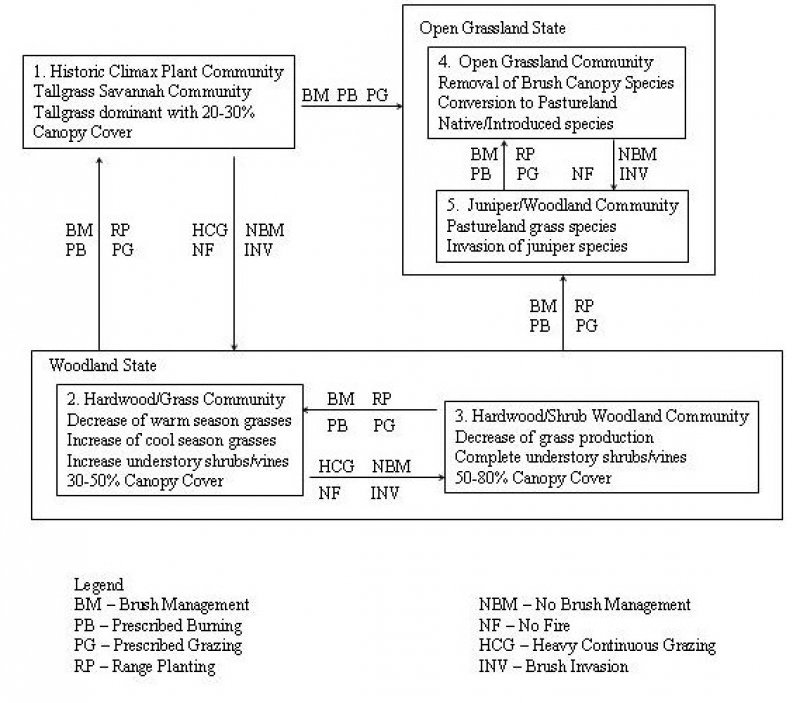
Figure 5. Clayey Bottomland - State & Transition Diagram
More interactive model formats are also available.
View Interactive Models
More interactive model formats are also available.
View Interactive Models
Click on state and transition labels to scroll to the respective text
State 1 submodel, plant communities
State 2 submodel, plant communities
State 3 submodel, plant communities
State 4 submodel, plant communities
State 5 submodel, plant communities
State 1
1. Tallgrass Savannah Community
Community 1.1
1. Tallgrass Savannah Community

Figure 6. 1. Tallgrass Savannah Community
The historic plant community for the clayey bottomland ecological site was a tallgrass savannah. The slope and location of the site on the landscape makes it a preferred site for all grazing animals. This preference makes the site very susceptible to overgrazing. Repeated overgrazing by livestock has led to the removal of little bluestem, big bluestem, Indiangrass, switchgrass and Eastern gamagrass from the community. The elimination of the tallgrasses allows the midgrasses and hardwood seedlings to establish. This moves the site away from the historic plant community to a grass/hardwood community. The increase in canopy cover can drastically reduce the grass and forb production on the site. There is a tendency for the warm-season grass and forb community to be replaced with cool-season and shade tolerant grasses and forbs as the woody canopy increases. Tree density and canopy cover increase in proximity nearest to the watercourse. The canopy cover adjacent to the defined channel may exceed 60% and grass production will be 50% of the upland portions of the site. A large variety of species occur due to the variations in the site.
Figure 7. Annual production by plant type (representative values) or group (midpoint values)
Table 5. Annual production by plant type
| Plant type | Low (kg/hectare) |
Representative value (kg/hectare) |
High (kg/hectare) |
|---|---|---|---|
| Grass/Grasslike | 2690 | 4035 | 4932 |
| Tree | 336 | 504 | 616 |
| Forb | 168 | 252 | 308 |
| Shrub/Vine | 168 | 252 | 308 |
| Total | 3362 | 5043 | 6164 |
Figure 8. Plant community growth curve (percent production by month). TX3773, Tallgrass Savannah -10-30% canopy cover. Tallgrasses with 10-30 percent canopy cover..
| Jan | Feb | Mar | Apr | May | Jun | Jul | Aug | Sep | Oct | Nov | Dec |
|---|---|---|---|---|---|---|---|---|---|---|---|
| J | F | M | A | M | J | J | A | S | O | N | D |
| 3 | 3 | 5 | 13 | 22 | 15 | 5 | 3 | 15 | 7 | 5 | 4 |
State 2
2. Hardwood/Grass Community
Community 2.1
2. Hardwood/Grass Community
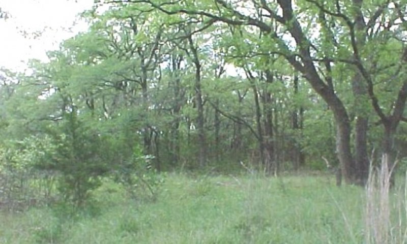
Figure 9. 2. Hardwood/Grass Community
This community is greatly influenced by the overstory canopy. The shading by the trees reduces warm season grass growth and helps to promote cool season plant growth. As the canopy thickens from 30% to 50%, the warm season grass component is replaced by the cool season and more shade tolerant warm season grass and forb species. There is also an increase of understory shrub and vine species. Woody species encroachment consists of juniper, mesquite, willow and the initial invasion of box-elder maple. Mechanical removal of trees and shrubs is necessary to move the site back toward the historic community. Reintroduction of the tall grass and high quality forb species by seeding will be necessary to allow the site to transition back to a tall grass savannah. Prescribed fire or some form of individual plant treatment will be needed to aid in control of hardwood seedlings. Not addressing the encroachment of hardwood seedlings will allow the overstory and understory shrub and vine canopy to increase to such an extent that grass and forbs will be eliminated from the site. At this point the site has transitioned to the Hardwood/Shrub Community (3) and crossed a threshold.
Figure 10. Annual production by plant type (representative values) or group (midpoint values)
Table 6. Annual production by plant type
| Plant type | Low (kg/hectare) |
Representative value (kg/hectare) |
High (kg/hectare) |
|---|---|---|---|
| Grass/Grasslike | 1625 | 2410 | 2970 |
| Tree | 673 | 1009 | 1233 |
| Shrub/Vine | 252 | 392 | 504 |
| Forb | 101 | 140 | 168 |
| Total | 2651 | 3951 | 4875 |
Figure 11. Plant community growth curve (percent production by month). TX3772, Hardwood/Grass Community. Hardwood trees with declining grass species..
| Jan | Feb | Mar | Apr | May | Jun | Jul | Aug | Sep | Oct | Nov | Dec |
|---|---|---|---|---|---|---|---|---|---|---|---|
| J | F | M | A | M | J | J | A | S | O | N | D |
| 4 | 5 | 7 | 12 | 20 | 13 | 5 | 4 | 13 | 7 | 5 | 5 |
State 3
3. Hardwood/Shrub Woodland Community
Community 3.1
3. Hardwood/Shrub Woodland Community
This community is a product of overgrazing, complete elimination of fire and mature hardwood encroachment. Overstory and understory canopies can increase to near 100%. At this level, box-elder, greenbrier (Smilax spp.) and associated shrubs can make the site almost impenetrable to man or large animals. In this condition, the site has lost its value for livestock production and deer habitat. Plant diversity may also be decreased. Only large inputs of capital for brush management and seeding, along with grazing management, will move the site back toward the tall grass savannah. Lowering canopy cover below what could have been expected as the historic climax plant community causes the site to move towards the open grassland community.
Figure 12. Annual production by plant type (representative values) or group (midpoint values)
Table 7. Annual production by plant type
| Plant type | Low (kg/hectare) |
Representative value (kg/hectare) |
High (kg/hectare) |
|---|---|---|---|
| Tree | 1345 | 2018 | 2466 |
| Shrub/Vine | 504 | 729 | 953 |
| Grass/Grasslike | 280 | 392 | 504 |
| Forb | 22 | 34 | 39 |
| Total | 2151 | 3173 | 3962 |
Figure 13. Plant community growth curve (percent production by month). TX3771, Hardwood/Shrub Woodland Community. Hardwood and shrub woodland community..
| Jan | Feb | Mar | Apr | May | Jun | Jul | Aug | Sep | Oct | Nov | Dec |
|---|---|---|---|---|---|---|---|---|---|---|---|
| J | F | M | A | M | J | J | A | S | O | N | D |
| 2 | 3 | 10 | 15 | 20 | 18 | 5 | 4 | 10 | 7 | 4 | 2 |
State 4
4. Open Grassland Community
Community 4.1
4. Open Grassland Community
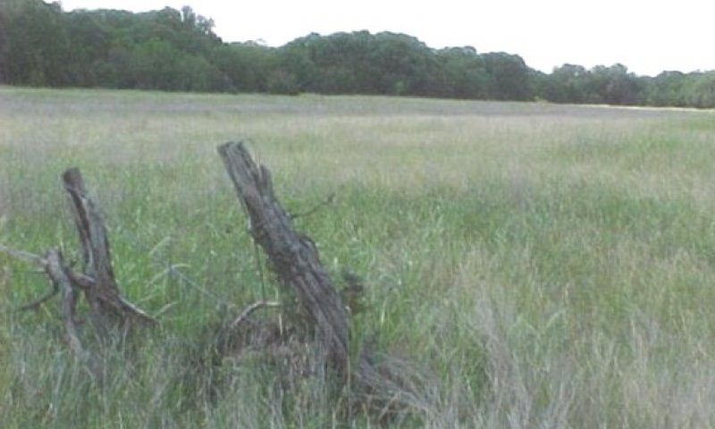
Figure 14. 4. Open Grassland Community
This community resulted because of the complete removal of the woody component of the site and/or this site at one time was used for cropland. Many times the cropland was converted to pastureland. Introduced species seeded include introduced bluestems (Bothriochloa spp.), kleingrass (Panicum coloratum) and bermudagrass (Cynodon dactylon). Native species planted for pastureland include switchgrass and Eastern gamagrass. Some of the areas were abandoned and allowed to revegetate naturally. This approach will normally lead to the bulk of production being made up of early successional grasses and forb species. The area can be seeded to a mixture of native grasses and forbs to better represent the grass and forb component of the historic plant community because a seed source is lacking. Prescribed grazing will be needed to maintain a desirable species composition. Prescribed burning and/or individual plant treatment of woody species will be needed to maintain the community as an open grassland site. Without some form of brush management the community will transition to the Juniper Woodland Community (5) and may include box-elder maple. It is very unlikely that this site will be able to revert to the historic plant community without intervention.
Figure 15. Annual production by plant type (representative values) or group (midpoint values)
Table 8. Annual production by plant type
| Plant type | Low (kg/hectare) |
Representative value (kg/hectare) |
High (kg/hectare) |
|---|---|---|---|
| Grass/Grasslike | 2018 | 4259 | 5604 |
| Shrub/Vine | 28 | 56 | 112 |
| Forb | 56 | 84 | 112 |
| Total | 2102 | 4399 | 5828 |
Figure 16. Plant community growth curve (percent production by month). TX3764, Open Grassland. Warm season grasses with minor cool season influence on open grassland..
| Jan | Feb | Mar | Apr | May | Jun | Jul | Aug | Sep | Oct | Nov | Dec |
|---|---|---|---|---|---|---|---|---|---|---|---|
| J | F | M | A | M | J | J | A | S | O | N | D |
| 1 | 1 | 5 | 15 | 25 | 20 | 7 | 5 | 13 | 5 | 2 | 1 |
State 5
5. Juniper Woodland Community
Community 5.1
5. Juniper Woodland Community
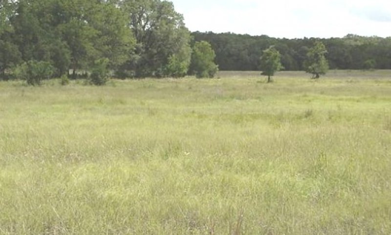
Figure 17. 5. Juniper Woodland Community
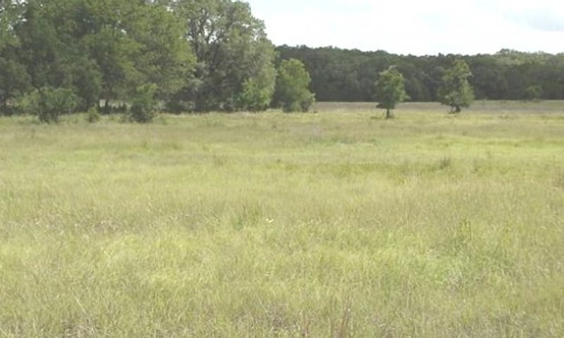
Figure 18. 5. Juniper Woodland Community
This community is characterized by the invasion of Ashe juniper and Box-elder maple into what was an open grassland. Left unchecked, the juniper can increase to an almost closed canopy in 10 to 20 years. Ashe juniper can be controlled by using prescribed burning as long as the trees are 4 foot or less in height. Some form of mechanical or chemical brush management will be required once the trees attain a height of greater than 4 feet.
Figure 19. Annual production by plant type (representative values) or group (midpoint values)
Table 9. Annual production by plant type
| Plant type | Low (kg/hectare) |
Representative value (kg/hectare) |
High (kg/hectare) |
|---|---|---|---|
| Grass/Grasslike | 1121 | 2242 | 2802 |
| Tree | 673 | 1009 | 1681 |
| Shrub/Vine | 252 | 392 | 504 |
| Forb | 56 | 84 | 168 |
| Total | 2102 | 3727 | 5155 |
Figure 20. Plant community growth curve (percent production by month). TX3767, Juniper Woodland. Invasion of Ashe Juniper encroaching open grassland..
| Jan | Feb | Mar | Apr | May | Jun | Jul | Aug | Sep | Oct | Nov | Dec |
|---|---|---|---|---|---|---|---|---|---|---|---|
| J | F | M | A | M | J | J | A | S | O | N | D |
| 2 | 3 | 10 | 15 | 20 | 18 | 5 | 4 | 10 | 7 | 4 | 2 |
Additional community tables
Table 10. Community 1.1 plant community composition
| Group | Common name | Symbol | Scientific name | Annual production (kg/hectare) | Foliar cover (%) | |
|---|---|---|---|---|---|---|
|
Grass/Grasslike
|
||||||
| 1 | Tallgrasses | 1513–2018 | ||||
| big bluestem | ANGE | Andropogon gerardii | 1513–2018 | – | ||
| switchgrass | PAVI2 | Panicum virgatum | 1513–2018 | – | ||
| little bluestem | SCSC | Schizachyrium scoparium | 1513–2018 | – | ||
| Indiangrass | SONU2 | Sorghastrum nutans | 1513–2018 | – | ||
| eastern gamagrass | TRDA3 | Tripsacum dactyloides | 1513–2018 | – | ||
| 2 | Warm/Cool season grasses | 404–605 | ||||
| Indian woodoats | CHLA5 | Chasmanthium latifolium | 404–605 | – | ||
| Canada wildrye | ELCA4 | Elymus canadensis | 404–605 | – | ||
| Virginia wildrye | ELVI3 | Elymus virginicus | 404–605 | – | ||
| southwestern bristlegrass | SESC2 | Setaria scheelei | 404–605 | – | ||
| purpletop tridens | TRFL2 | Tridens flavus | 404–605 | – | ||
| 3 | Warm/Cool season grasses | 404–605 | ||||
| Scribner's rosette grass | DIOLS | Dichanthelium oligosanthes var. scribnerianum | 404–605 | – | ||
| plains lovegrass | ERIN | Eragrostis intermedia | 404–605 | – | ||
| Texas wintergrass | NALE3 | Nassella leucotricha | 404–605 | – | ||
| 4 | Midgrasses | 404–605 | ||||
| cane bluestem | BOBA3 | Bothriochloa barbinodis | 404–605 | – | ||
| sideoats grama | BOCU | Bouteloua curtipendula | 404–605 | – | ||
| silver beardgrass | BOLAT | Bothriochloa laguroides ssp. torreyana | 404–605 | – | ||
| 5 | Mid/shortgrasses | 202–303 | ||||
| buffalograss | BODA2 | Bouteloua dactyloides | 202–303 | – | ||
| vine mesquite | PAOB | Panicum obtusum | 202–303 | – | ||
| 6 | Midgrasses | 404–605 | ||||
| Texas cupgrass | ERSE5 | Eriochloa sericea | 404–605 | – | ||
| threeflower melicgrass | MENI | Melica nitens | 404–605 | – | ||
| composite dropseed | SPCOC2 | Sporobolus compositus var. compositus | 404–605 | – | ||
| Drummond's dropseed | SPCOD3 | Sporobolus compositus var. drummondii | 404–605 | – | ||
| white tridens | TRAL2 | Tridens albescens | 404–605 | – | ||
|
Forb
|
||||||
| 7 | Annual/Perennial Forbs | 202–303 | ||||
| Forb, annual | 2FA | Forb, annual | 202–303 | – | ||
| great ragweed | AMTR | Ambrosia trifida | 202–303 | – | ||
| aster | ASTER | Aster | 202–303 | – | ||
| spiny chloracantha | CHSP11 | Chloracantha spinosa | 202–303 | – | ||
| Maximilian sunflower | HEMA2 | Helianthus maximiliani | 202–303 | – | ||
| Gregg's tube tongue | JUPI5 | Justicia pilosella | 202–303 | – | ||
| yellow puff | NELU2 | Neptunia lutea | 202–303 | – | ||
| least snoutbean | RHMI4 | Rhynchosia minima | 202–303 | – | ||
| wild petunia | RUELL | Ruellia | 202–303 | – | ||
| awnless bushsunflower | SICA7 | Simsia calva | 202–303 | – | ||
| goldenrod | SOLID | Solidago | 202–303 | – | ||
| creepingoxeye | WEDEL | Wedelia | 202–303 | – | ||
|
Shrub/Vine
|
||||||
| 8 | Shrubs/Vines | 202–303 | ||||
| peppervine | AMPEL3 | Ampelopsis | 202–303 | – | ||
| hackberry | CELTI | Celtis | 202–303 | – | ||
| intermediate treebine | CIIN3 | Cissus intermedia | 202–303 | – | ||
| leather flower | CLEMA | Clematis | 202–303 | – | ||
| kidneywood | EYSEN | Eysenhardtia | 202–303 | – | ||
| stretchberry | FOPU2 | Forestiera pubescens | 202–303 | – | ||
| possumhaw | ILDE | Ilex decidua | 202–303 | – | ||
| Japanese honeysuckle | LOJA | Lonicera japonica | 202–303 | – | ||
| bully | SIDER2 | Sideroxylon | 202–303 | – | ||
| greenbrier | SMILA2 | Smilax | 202–303 | – | ||
| eastern poison ivy | TORA2 | Toxicodendron radicans | 202–303 | – | ||
| mustang grape | VIMU2 | Vitis mustangensis | 202–303 | – | ||
|
Tree
|
||||||
| 9 | Trees | 404–605 | ||||
| hybrid hickory | CARYA | Carya | 404–605 | – | ||
| cypress | CUPRE | Cupressus | 404–605 | – | ||
| walnut | JUGLA | Juglans | 404–605 | – | ||
| Texas mulberry | MOMI | Morus microphylla | 404–605 | – | ||
| American sycamore | PLOC | Platanus occidentalis | 404–605 | – | ||
| pallid hoptree | PTTRP | Ptelea trifoliata ssp. pallida | 404–605 | – | ||
| live oak | QUVI | Quercus virginiana | 404–605 | – | ||
| willow | SALIX | Salix | 404–605 | – | ||
| elm | ULMUS | Ulmus | 404–605 | – | ||
Interpretations
Animal community
This site is used for the production of domestic livestock and to provide habitat for native wildlife and certain species of exotic wildlife. Cow-calf operations are the primary livestock enterprise although stocker cattle are also grazed. Sheep and goats were formerly raised in large numbers and are still present in reduced numbers. Carrying capacity has declined drastically over the past 100 years due to deterioration of the historic climax plant community. An assessment of vegetation is needed to determine stocking rates.
A large diversity of wildlife is native to this site. In the historic climax plant community, large migrating herds of bison, resident herds of pronghorn and large numbers of greater prairie chickens were the more dominant species. With the demise of these species and the changes in the plant community, the kinds of wildlife have changed.
With the eradication of the screw worm fly, the increase in woody vegetation and insufficient natural predation, white-tailed deer numbers have increased drastically and are often in excess of carrying capacity. Where deer numbers are excessive, overbrowsing and overuse of preferred forbs causes deterioration of the plant community. Progressive management of deer populations through hunting can keep populations in balance and provide an economically important ranching enterprise. Achieving a balance between woodland and more open plant communities on this site is an important key to deer management. Competition among deer, sheep and goats is an important consideration in livestock and wildlife management and can cause damage to preferred vegetation.
Smaller mammals include many kinds of rodents, jackrabbit, cottontail rabbit, raccoon, skunks, possum and armadillo. Mammalian predators include coyote, red fox, gray fox, bobcat, and mountain lion. Many species of snakes and lizards are native to the site.
Many species of birds are found on this site including game birds, songbirds and birds of prey. Major game birds that are economically important are Rio Grande turkey, bobwhite quail and mourning dove. Turkey prefers plant communities with substantial amounts of shrubs and trees interspersed with grassland. Quail prefer plant communities with a combination of low shrubs, bunch grass, bare ground and low successional forbs. The different species of songbirds vary in their habitat preferences. In general, habitat that provides a large variety of grasses, forbs, shrubs, vines and trees and a complex of grassland, savannah, shrubland and woodland will support a good variety and abundance of songbirds. Birds of prey are important to keep the numbers of rodents, rabbits and snakes in balance. The different plant communities of the site will sustain different species of raptors.
Various kinds of exotic wildlife have been introduced on the site including axis, sika, fallow and red deer, auodad sheep and blackbuck antelope. Their numbers should be managed in the same manner as livestock and white-tailed deer to prevent damage to the plant community. Feral hogs are present and can cause damage when their numbers are not managed.
Hydrological functions
The water cycle on this site is a reflection of the existing plant community and the management of that plant community. The water cycle is most functional when the site is dominated by tall bunchgrass. Rapid rainfall infiltration, high soil organic matter, good soil structure and good porosity are present with a good cover of bunchgrass. Quality of surface runoff will be high and erosion and sedimentation rates will be low. With high rates of infiltration and periods of heavy rainfall, some water will move below the root zone of grasses into the fractures in the limestone. As this water moves downward it contributes to the recharge of aquifers in certain geological formations and helps provide sustained streamflow.
When heavy grazing causes loss or reduction of bunchgrass and ground cover, the water cycle becomes impaired. Infiltration is decreased and runoff is increased due to poor ground cover, rainfall splash, soil capping, low organic matter and poor structure. Due to the very high shrink-swell clay soil and the formation of surface cracks in dry periods, rainfall infiltration can still occur even when ground cover is poor. With a combination of a sparse ground cover and intensive rainfall, this site can contribute to an increased frequency and severity of flooding within a watershed. Soil erosion is accelerated, quality of surface runoff is poor and sedimentation increased. The streambank can unravel.
As the site becomes dominated by woody species, especially oaks and juniper, the water cycle is further altered. Interception of rainfall by tree canopies is increased which reduces the amount of rainfall reaching the surface. Stemflow is increased, however, due to the funneling effect of the canopy, which increases soil moisture at the base of the tree. Increased transpiration, especially when evergreen species such as liveoak and juniper dominate, provides less chance for deep percolation into aquifers. As woody species increase, grass cover declines, which causes some of the same results as heavy grazing. Brush management combined with good grazing management can help restore the natural hydrology of the site.
If a mature woodland canopy develops, a buildup of leaf litter occurs which increases the organic matter of the soil, builds structure, improves infiltration and retards erosion. Some, but not all values of a properly functioning water cycle are restored on this site when a woodland plant community persists.
Recreational uses
This site has the appeal of the wide open spaces. The abundant tall and mid grasses and scattered oaks produce beautiful fall color variations. The area is also used for hunting, birding and other eco-tourism related enterprises.
Wood products
Honey mesquite and oaks can be used for firewood and the specialty wood industry.
Other products
None
Other information
None
Supporting information
Other references
This site was completed for Camp Bullis Military Reservation in Bexar County, Texas. Modifications were made to make the site suitable for the entire MLRA in 81C.
Contributors
Carl Englerth
Charles Anderson
Approval
David Kraft, 9/20/2019
Rangeland health reference sheet
Interpreting Indicators of Rangeland Health is a qualitative assessment protocol used to determine ecosystem condition based on benchmark characteristics described in the Reference Sheet. A suite of 17 (or more) indicators are typically considered in an assessment. The ecological site(s) representative of an assessment location must be known prior to applying the protocol and must be verified based on soils and climate. Current plant community cannot be used to identify the ecological site.
| Author(s)/participant(s) | |
|---|---|
| Contact for lead author | |
| Date | 06/02/2005 |
| Approved by | Colin Walden |
| Approval date | |
| Composition (Indicators 10 and 12) based on | Annual Production |
Indicators
-
Number and extent of rills:
None. -
Presence of water flow patterns:
Water flow patterns are common and follow old stream meanders. Deposition or erosion is uncommon for normal rainfall but may occur during intense rainfall events. -
Number and height of erosional pedestals or terracettes:
Pedestals or terracettes would have been uncommon for this site. -
Bare ground from Ecological Site Description or other studies (rock, litter, lichen, moss, plant canopy are not bare ground):
Expect no more than 20% bare ground randomly distributed throughout and in small and non-connected areas. -
Number of gullies and erosion associated with gullies:
Some gullies may be present on side drains into perennial and intermittent streams. Gullies should be vegetated and stable. -
Extent of wind scoured, blowouts and/or depositional areas:
None -
Amount of litter movement (describe size and distance expected to travel):
This is a flood plain with occasional out of bank flow. Under normal rainfall, little litter movement should be expected; however, litter of all sizes may move long distances depending on obstructions under intense storm events. -
Soil surface (top few mm) resistance to erosion (stability values are averages - most sites will show a range of values):
Soil surface is resistant to erosion. Stability class range is expected to be 5-6. -
Soil surface structure and SOM content (include type of structure and A-horizon color and thickness):
Soil surface structure is 0 to 48 inches thick with colors from dark reddish brown clay to very dark gray clay with generally subangular blocky structure. SOM is approximately 1-6%. -
Effect of community phase composition (relative proportion of different functional groups) and spatial distribution on infiltration and runoff:
The savannah of trees, shrubs, vines, grasses and forbs with adequate litter and little bare ground provides for maximum infiltration and little runoff under normal rainfall events. -
Presence and thickness of compaction layer (usually none; describe soil profile features which may be mistaken for compaction on this site):
No evidence of compaction. -
Functional/Structural Groups (list in order of descending dominance by above-ground annual-production or live foliar cover using symbols: >>, >, = to indicate much greater than, greater than, and equal to):
Dominant:
Cool-season grassesSub-dominant:
Warm-season tallgrasses Warm-season midgrassesOther:
Trees Shrubs ForbsAdditional:
-
Amount of plant mortality and decadence (include which functional groups are expected to show mortality or decadence):
There should be little mortality or decadence for any functional group. -
Average percent litter cover (%) and depth ( in):
Dominant litter is herbaceous with small to large woody litter common. -
Expected annual annual-production (this is TOTAL above-ground annual-production, not just forage annual-production):
4000# for below average moisture to 7000# for above average moisture. -
Potential invasive (including noxious) species (native and non-native). List species which BOTH characterize degraded states and have the potential to become a dominant or co-dominant species on the ecological site if their future establishment and growth is not actively controlled by management interventions. Species that become dominant for only one to several years (e.g., short-term response to drought or wildfire) are not invasive plants. Note that unlike other indicators, we are describing what is NOT expected in the reference state for the ecological site:
Potential invasives for this site include Chinese tallow, huisache, honey locust, bois d''''arc, elm, ash, mccartney rose, dallisgrass, bermudagrass, johnsongrass, annual sumpweed, giant ragweed, and King Ranch bluestem. -
Perennial plant reproductive capability:
All perennial plants should be capable of reproducing, except during periods of prolonged drought conditions, heavy natural herbivory or intense wildfires.
Print Options
Sections
Font
Other
The Ecosystem Dynamics Interpretive Tool is an information system framework developed by the USDA-ARS Jornada Experimental Range, USDA Natural Resources Conservation Service, and New Mexico State University.
Click on box and path labels to scroll to the respective text.