Natural Resources
Conservation Service
Ecological site F094DY005WI
Sandy Uplands
Accessed: 02/08/2026
General information
Provisional. A provisional ecological site description has undergone quality control and quality assurance review. It contains a working state and transition model and enough information to identify the ecological site.

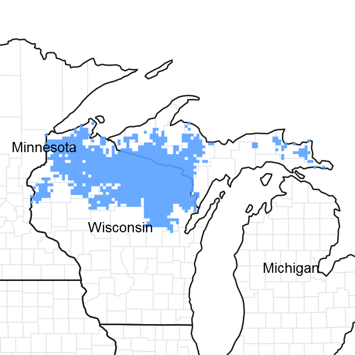
Figure 1. Mapped extent
Areas shown in blue indicate the maximum mapped extent of this ecological site. Other ecological sites likely occur within the highlighted areas. It is also possible for this ecological site to occur outside of highlighted areas if detailed soil survey has not been completed or recently updated.
MLRA notes
Major Land Resource Area (MLRA): 094D–Northern Highland Sandy Pitted Outwash
The Northern Highland Sandy Drift region (also referred to as MLRA 94D) lies mostly in northern Wisconsin with a few narrow outwash channels extending into the upper peninsula of Michigan. MLRA 94D encompasses 1.364 million acres and is surrounded by much larger, geologically different MLRAs. MLRA 94D is characterized mainly by sandy and gravelly soils formed in outwash sediments deposited by melt-water streams from late Wisconsin-Age glaciers, which receded from the area about 10,000 years before present (Attig 1985). The Sandy Uplands ecological site occupies about 300,000 acres in MLRA 94D.
Classification relationships
The Sandy Uplands ecological sites correlate to the PArV habitat type developed by Kotar et al (2002); this habitat type is named after Pinus strobus (white pine)-Acer rubrum (red maple)/Vaccinium angustifolium (low-bush blueberry). These species have very high constancy value relative to this site, i.e. they are present on a higher percentage of these sites than other species. This ecological site has a dry moisture regime and is poor in nutrients.
This ecological site is well described in the literature. This site correlates to the Northern Dry Forest after Curtis (1971), the PArV Habitat Type described by Kotar et al (2002) and the White Pine-Red Pine-Oak Forest Group of the National Vegetation Classification System.
Ecological site concept
The Sandy Uplands ecological site represents the dry northern forest, formerly dominated by large red and white pines, now a mix of hardwoods and conifers. This the most extensive ecological site in the MLRA and as such has the most variability in vegetation. This extensive old-growth pine forests that were found on this site were logged off in the late 1800's and early 1900's. Much of the cutover land was cleared for farming, mainly small-scale farms that supplied the local population. Most of these farms faded from scene because they couldn't be as productive as farms to the south. Many sites reverted to forest naturally, many were planted to red pine starting in the 1930's. The result is patchwork landscape of second- and third-growth forests, clearings of various sizes, modern agricultural land--some of which is irrigated, woodland home sites and hunting cabins. Some of the pine forests are attaining the stature of the former mature pine trees on the site, but the multi-layered old growth forest structure is rare.
Similar sites
| F094DY006WI |
Steep Sandy Ridges The transition to Steep Sandy Ridges from Sandy Uplands occurs gradually over several percent of slope gradient; 16 percent is less of a cutoff than an inflection point in an S-curve of ecological change (both floristically and environmentally). |
|---|
Table 1. Dominant plant species
| Tree |
(1) Pinus resinosa |
|---|---|
| Shrub |
(1) Vaccinium angustifolium |
| Herbaceous |
(1) Gaultheria procumbens |
Click on box and path labels to scroll to the respective text.