Natural Resources
Conservation Service
Ecological site F096XB022MI
Wet Acidic Sandy Depression
Last updated: 9/11/2024
Accessed: 02/07/2026
General information
Provisional. A provisional ecological site description has undergone quality control and quality assurance review. It contains a working state and transition model and enough information to identify the ecological site.

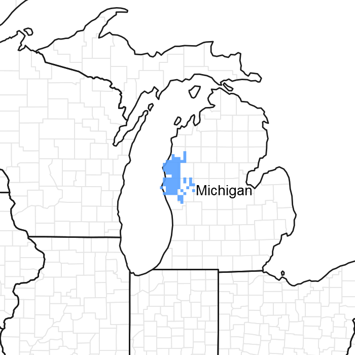
Figure 1. Mapped extent
Areas shown in blue indicate the maximum mapped extent of this ecological site. Other ecological sites likely occur within the highlighted areas. It is also possible for this ecological site to occur outside of highlighted areas if detailed soil survey has not been completed or recently updated.
MLRA notes
Major Land Resource Area (MLRA): 096X–Northwestern Michigan Fruit Belt
This area is dominated by outwash plains and moraines. Lake plains, till plains, drumlins, and sand dunes are found locally across the area. The terrain is steep on stream carved moraines, ice contact ridges, and sand dunes, and flat on outwash plains and lake plains. Elevation ranges from 177 to 369 m (580 to 1210 ft). Local topographic relief averages 11 m (35 ft) in the south to 20 m (65 ft) in the north and ranges up to a maximum of 158 m (520 ft) at Empire Bluff (Sleeping Bear Dunes). Much of the area rises sharply from the lakeshore to the adjoining hilltops. The Manistee River is the longest river in this area. Its trout fishery is maintained by constant inflow of cool ground water from the porous sand dominated landscape. The Pine and Pere Marquette Rivers also occur in this MLRA. Surficial topography are formed of glacial deposits except for local areas with dune building near Lake Michigan. Most of the bedrock surface is at or below the elevation of Lake Michigan, and is exposed in only in limited extents near Charlevoix. The bedrock, all Paleozoic in age, is the Traverse Group and the Dundee Limestone. These Silurian-Devonian rocks are mostly limestone and dolomite with some interbedded shale, chert, and anhydrite stringers. The drumlin belts in the northern portion of the area is the most affected by the limestone nearer to the surface in terms of carbonates in the till.
About two-thirds of this area is in small, privately owned holdings, and one-third consists mostly of State forests. The forests are used mainly for timber production and recreation. The growth of orchard crops and other crops and dairy and beef operations are important enterprises in the area. Forage and feed grains for dairy and other livestock are the principal crops. Asparagus, wheat, oats, corn, and hay are commonly grown in the area. Orchard products include sweet and tart cherries, apples, plums, and peaches. The Manistee National Forest and Sleeping Bear Dunes National Lakeshore are among the more notable conservation lands in the area. Nordhouse Dunes Wilderness Area is within the Manistee National Forest. Sections of the Pere Marquette, Pine, and Manistee Rivers, and Bear Creek have been designated as National Wild and Scenic Rivers.
Summary of existing land use:
Upland Forest (52%)
Hardwood (38%)
Conifer (11%)
Agricultural (15%)
Swamps and Marshes (13%)
Developed (13%)
Classification relationships
According to the USFS (Bailey) system of ecoregions, the site is located mostly within 212Ha (Oceana Sandy Lake Plains and Dunes) and 212Hb (Manistee Sandy Outwash Plain) subsections. According to the EPA (Omernik) system of ecoregions, the site is located in 50ag (Newaygo Barrens) and northern 56d (Michigan Lake Plain) level IV ecoregions. This site is outside the environmental range of the Kotar system. This site corresponds to the Mineral Wetland, ecological land type phase, 72, in the USFS Ecological Land Type system.
Ecological site concept
The central concept of Wet Acidic Sandy Depression is lowlands with hydric soil (poorly drained to very poorly drained) and a soil pH of the upper 50 cm less than 5.5, and a low base saturation, including Spodosols, Ultic subgroups, and dysic great groups and families. Site occurs on sandy drift (outwash, ice contact, or lake plains) where soil textures are sand or loamy sand (upper 50 cm >70% sand). Site in moderate annual snowfall belt, mostly south of Manistee River, where fire was locally important. Area has a more southern flora than sites further north. Vegetation tended towards swamp forest with an acidophilic species composition.
Associated sites
| F096XB021MI |
Acidic Sandy Depression |
|---|
Similar sites
| F096XA009MI |
Snowy Wet Acidic Sandy Depression |
|---|
Table 1. Dominant plant species
| Tree |
(1) Tsuga canadensis |
|---|---|
| Shrub |
(1) Vaccinium corymbosum |
| Herbaceous |
(1) Osmundastrum cinnamomeum |
Click on box and path labels to scroll to the respective text.