Natural Resources
Conservation Service
Ecological site R107XA202IA
Calcareous Till Upland Prairie
Last updated: 5/21/2020
Accessed: 01/10/2025
General information
Provisional. A provisional ecological site description has undergone quality control and quality assurance review. It contains a working state and transition model and enough information to identify the ecological site.
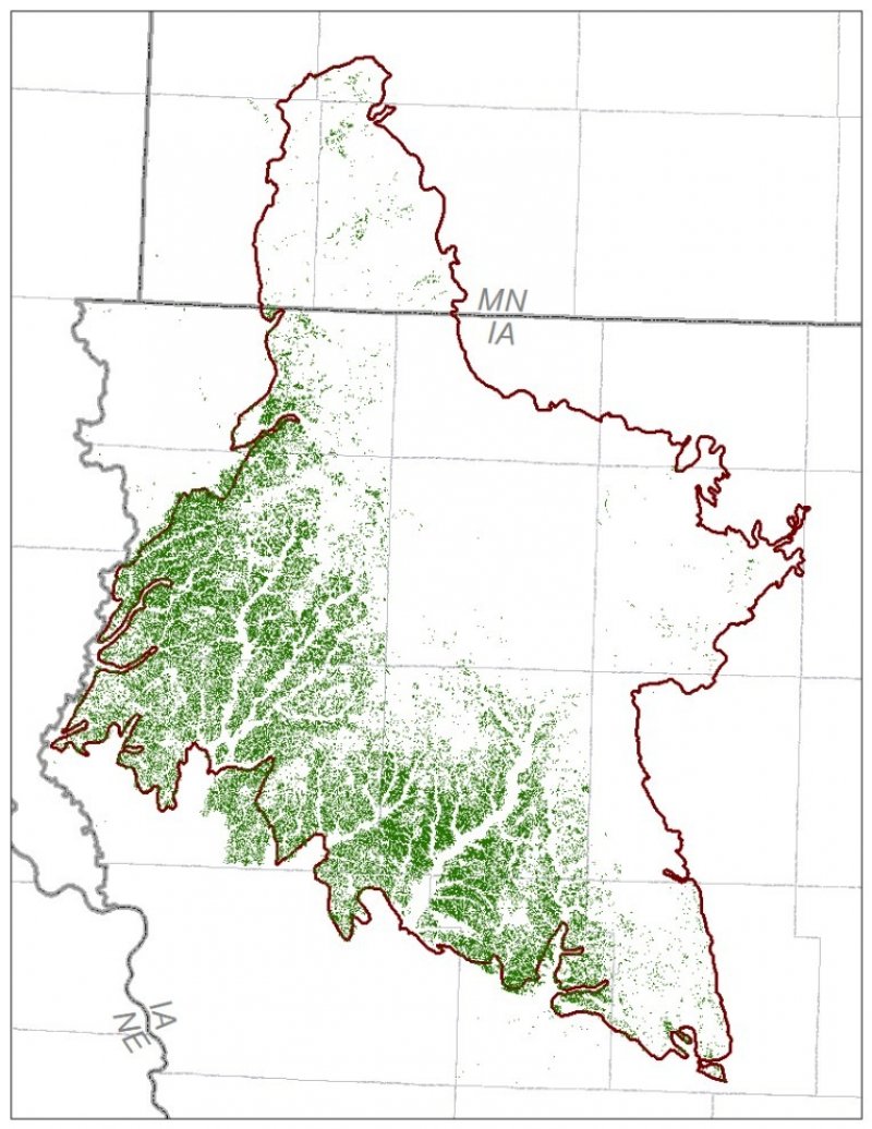
Figure 1. Mapped extent
Areas shown in blue indicate the maximum mapped extent of this ecological site. Other ecological sites likely occur within the highlighted areas. It is also possible for this ecological site to occur outside of highlighted areas if detailed soil survey has not been completed or recently updated.
MLRA notes
Major Land Resource Area (MLRA): 107X–Iowa and Missouri Deep Loess Hills
The Iowa and Minnesota Loess Hills (MLRA 107A) includes the Northwest Iowa Plains, Inner Coteau, and Coteau Moraines landforms (Prior 1991; MDNR 2005). It spans two states (Iowa, 89 percent; Minnesota, 11 percent), encompassing approximately 4,470 square miles (Figure 1). The elevation ranges from approximately 1,700 feet above sea level (ASL) on the highest ridges to about 1,115 feet ASL in the lowest valleys. Local relief is mainly 10 to 100 feet. However, some valley floors can range from 80 to 200 feet, while some upland flats only range between 3 and 6 feet. The eastern half of the MLRA is underlain by Wisconsin-age till, deposited between 20,000 and 30,000 years ago and is known as the Sheldon Creek Formation. The western half is underlain by Pre-Illinoian glacial till, deposited more than 500,000 years ago and has since undergone extensive erosion and dissection. Both surfaces are covered by approximately 4 to 20 feet of loess on the hillslopes, and Holocene alluvium covers the till in the drainageways. Cretaceous bedrock, comprised of sandstone and shale, lies beneath the glacial material (USDA-NRCS 2006).
The vegetation in the MLRA has undergone drastic changes over time. Spruce forests dominated the landscape 30,000 to 21,500 years ago. As the last glacial maximum peaked 21,500 to 16,000 years ago, they were replaced with open tundras and parklands. The end of the Pleistocene Epoch saw a warming climate that initially prompted the return of spruce forests, but as the warming continued, spruce trees were replaced by deciduous trees (Baker et al. 1990). Not until approximately 9,000 years ago did the vegetation transition to prairies as climatic conditions continued to warm and subsequently dry. Between 4,000 and 3,000 years ago, oak savannas began intermingling within the prairie landscape, while the more wooded and forested areas maintained a foothold in sheltered areas. This prairie-forest transition ecosystem formed the dominant landscapes until the arrival of European settlers (Baker et al. 1992).
Classification relationships
U.S. Forest Service Ecological Subregions: North Central Glaciated Plains (251B) Section, Outer Coteau des Prairies (251Bb), Northwest Iowa Plains (251Bd) Subsections (Cleland et al. 2007)
U.S. EPA Level IV Ecoregion: Loess Prairies (47a) (USEPA 2013)
National Vegetation Classification – Ecological Systems: Northern Tallgrass Prairie (CES205.686) (NatureServe 2015)
National Vegetation Classification - Plant Associations: Andropogon gerardii – Hesperostipa spartea – Sporobolus heterolepis (CEGL002202) (NatureServe 2015)
Biophysical Settings: Northern Tallgrass Prairie (BpS 4214200) (LANDFIRE 2009)
Natural Resources Conservation Service – Iowa Plant Community Species List: Prairie, Northern Mesic Tallgrass (USDA-NRCS 2007)
Iowa Department of Natural Resources: Blacksoil Tallgrass Prairie (INAI 1984)
Minnesota Department of Natural Resources: Ups23a Mesic Prairie (Southern) (MDNR 2005)
Ecological site concept
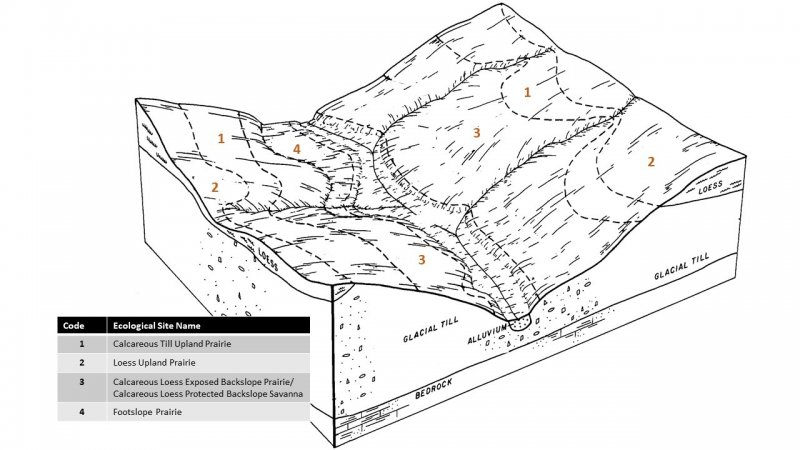
Calcareous Till Upland Prairies are located within the green areas on the map (Figure 1). They occur on upland summits and shoulders, and the soils are Mollisols, Entisols, and Inceptisols that are well-drained and deep, formed in calcareous glacial till. These fine-loamy soils have organic-rich surfaces with high base saturation and will intermittently dry out for periods during the summer season (MDNR 2005; NatureServe 2015).
The historic pre-European settlement vegetation on this site was dominated by herbaceous tallgrass species. Big bluestem (Andropogon gerardii Vitman) and little bluestem (Schizachyrium scoparium (Michx.) Nash) are the dominant grasses of this ecological site. Other grasses that may occur include Indiangrass (Sorghastrum nutans (L.) Nash), porcupinegrass (Hesperostipa spartea (Trin.) Barkworth), and prairie dropseed (Sporobolus heterolepis (A. Gray) A. Gray) (MDNR 2005). Forbs typical of an undisturbed plant community associated with this ecological site include white prairie clover (Dalea candida Michx. ex Willd.), purple prairie clover (Dalea purpurea Vent.), and meadow zizia (Zizia aptera (A. Gray) Fernald) (Drobney et al. 2001; MDNR 2005). Patches of shrubs can be present and generally include leadplant (Amorpha canescens Pursh) and prairie rose (Rosa arkansana Porter) (MDNR 2005). Fire and herbivory are the primary disturbance factors that maintain this site, while drought is a secondary factor (MDNR 2005; LANDFIRE 2009).
Associated sites
| R107XA204IA |
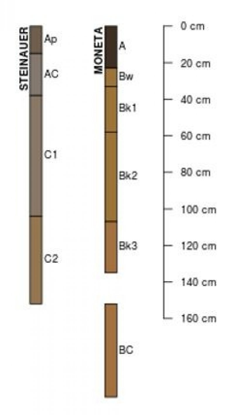
Calcareous Till Protected Backslope Savanna Glacial till on backslopes with north and east-facing aspects including Cornell, Moneta, Steinauer, Steinauer variant, and soils that are moderately deep to carbonates |
|---|---|
| R107XA201IA |
Loess Upland Prairie Loess on uplands including Annieville, Galva, McCreath, Primghar, Primghar variant, Ransom, Sac, Sac variant, and Wilmonton |
| R107XA205IA |
Loamy Sediment Upland Prairie Loamy sediments on uplands including Bolan, Bolan variant, Dickman, Everly, Fostoria, and Ocheyedan |
| R107XA203IA |
Calcareous Till Exposed Backslope Prairie Glacial till on backslopes with south and west-facing aspects including Cornell, Moneta, Steinauer, Steinauer variant, and soils that are moderately deep to carbonates |
Similar sites
| R107XA201IA |
Loess Upland Prairie Loess Upland Prairies are derived from fine-silty loess |
|---|---|
| R107XA205IA |
Loamy Sediment Upland Prairie Loamy Sediment Upland Prairies are derived from fine-loamy sediments |
| R107XA203IA |
Calcareous Till Exposed Backslope Prairie Calcareous Till Exposed Backslope Prairies are derived from the same parent material but occur on slopes greater than 20 percent and have a south and west aspect |
| R107XA204IA |
Calcareous Till Protected Backslope Savanna Calcareous Till Protected Backslope Savannas are derived from the same parent material but occur on slopes greater than 20 percent and have a north and east aspect |
Table 1. Dominant plant species
| Tree |
Not specified |
|---|---|
| Shrub |
(1) Amorpha canescens |
| Herbaceous |
(1) Andropogon gerardii |
Click on box and path labels to scroll to the respective text.
