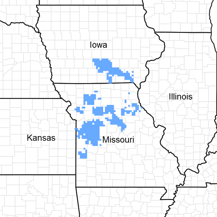
Ecological dynamics
Information contained in this section was developed using historical data, professional experience, field reviews, and scientific studies. The information presented is representative of very complex vegetation communities. Key indicator plants, animals and ecological processes are described to help inform land management decisions. Plant communities will differ across the MLRA because of the naturally occurring variability in weather, soils, and aspect. The Reference Plant Community is not necessarily the management goal. The species lists are representative and are not botanical descriptions of all species occurring, or potentially occurring, on this site. They are not intended to cover every situation or the full range of conditions, species, and responses for the site.
Fire played an important role in the maintenance of these systems. Because these sites normally occur next to the prairie edge, it is likely that these ecological sites burned at least once every 3 to 5 years. These periodic fires kept woodlands open, removed the litter, and stimulated the growth and flowering of the grasses and forbs. During fire free intervals, woody understory species increased and the herbaceous understory diminished. The return of fire would open the woodlands up again and stimulate the abundant ground flora.
Today, this community has either been cleared and converted to pasture or cropland, or has grown dense in the absence of fire. Most occurrences today exhibit canopy closure of 80 to 100 percent. In addition, the sub-canopy and understory layers are better developed. Black oak and hickory now share dominance with white oak and there are considerable more saplings in the understory. Under these denser, more shaded conditions, the original sun-loving ground flora has diminished in diversity and cover. While some woodland species persist in the ground flora, many have been replaced by more shade-tolerant species.
In the long term absence of fire, woody species, especially hickory, hornbeam and gooseberry encroach into these woodlands. Once established, these woody plants can quickly fill the existing understory increasing shade levels greatly diminishing the ground flora. Removal of the younger understory and the application of prescribed fire have proven to be effective management tools.
Uncontrolled domestic grazing has also impacted these communities, further diminishing the diversity of native plants and introducing species that are tolerant of grazing, such as coralberry, gooseberry, and Virginia creeper. Grazed sites also have a more open understory. In addition, on grazed sites soil compaction and soil erosion can be a problem and lower productivity.
This ecological site, if managed properly, can be a source for timber products especially white oak. Most areas on this ecological site have been repeatedly logged and high graded. Even-age management, using clearcut, or shelterwood and seed-tree harvest systems without fire will perpetuate the overly dense, shaded conditions. Thinning and/or occasional partial cuts, using an uneven-age management system can provide sunlight to the woodland floor, stimulating native woodland ground flora.
However, in the absence of fire and continual cultural treatments, oak sprouting creates a dense stand, again shading out the sun-loving ground flora. Partial cutting and prescribed fire can restore the more open structure and diversity of ground flora species. This type of site with proper management can provide timber products, wildlife habitat, and potential native forage.
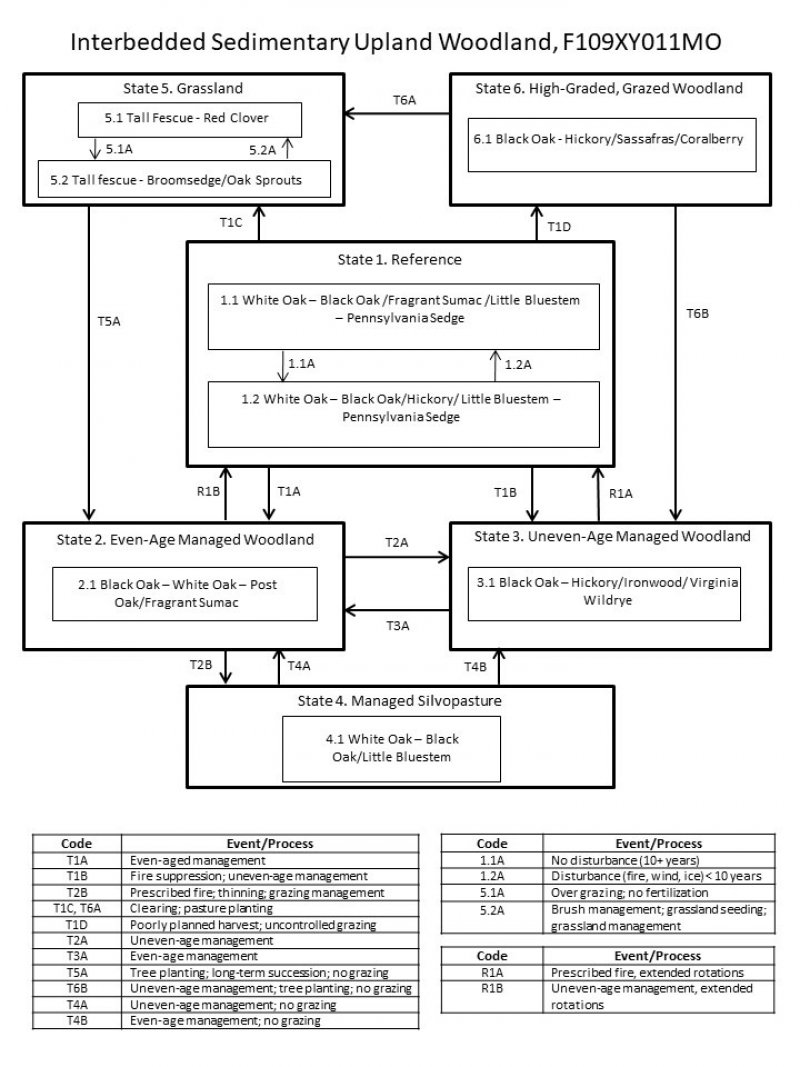
A State and Transition Diagram follows. Detailed descriptions of each state, transition, plant community, and pathway follow the model. This model is based on available experimental research, field observations, professional consensus, and interpretations. It is likely to change as knowledge increases.
State 1
Reference
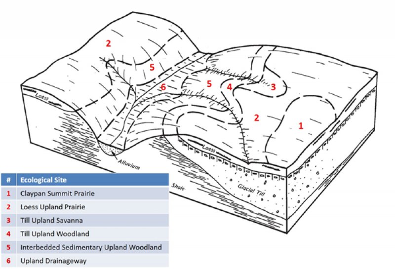
The reference plant community is woodland dominated by an overstory of white oak and black oak. This woodland type has a moderate canopy closure (50 to 80 percent), with an open understory and a dense, diverse herbaceous ground flora. Historically, white oak dominated the canopy, along with black oak and occasional hickories, bur oak and post oak. Woodlands are distinguished from forest, by their relatively open understory, and the presence of sun-loving ground flora species including the dominant prairie grasses. Characteristic plants in the ground flora can be used to gauge the restoration potential of a stand along with remnant open-grown old-age trees, and tree height growth.
Community 1.1
White Oak-Black Oak/Aromatic Sumac/Little Bluestem-Pennsylvania Sedge
This phase has an overstory that is dominated by white oak and black oak with hickory and post oak also present. This woodland community has a two-tiered structure with an open understory and a dense, diverse herbaceous ground flora.
Periodic disturbances including fire, ice and wind create canopy gaps, allowing white oak and black oak to successfully reproduce and remain in the canopy.
Forest overstory. The Forest Overstory Species list is based on commonly occurring species listed in Nelson (2010).
Forest understory. The Forest Understory list is based on commonly occurring species listed in Nelson (2010).
Community 1.2
White Oak-Black Oak/Hickory/Little Bluestem-Pennsylvania Sedge
This phase is similar to community phase 1.1 but oak and hickory understory densities are increasing due to longer periods of fire suppression. Displacement of some grasses and forbs may be occurring due to shading and competition from the increased densities of oak and hickory saplings in the understory.
Pathway 1.1A
Community 1.1 to 1.2
No disturbance (10+ years)
Pathway 1.2A
Community 1.2 to 1.1
Disturbance (fire, wind, ice) <10 years
State 2
Even-Age Managed Woodland
These woodlands tend to be rather dense, with a sparse understory and ground flora. Thinning can increase overall tree vigor and improve understory diversity. However, in the absence of fire, the diversity and cover of the ground flora is diminished. Continual timber management, depending on the practices used, will either maintain this state, or convert the site to uneven-age (State 3) woodlands.
Community 2.1
Black Oak-White Oak-Post Oak/Aromatic Sumac
State 3
Uneven-Age Managed Woodland
Uneven-Age Managed Woodlands resemble their reference state. The biggest difference is tree age, most being only 60 to 90 years old. Composition is also likely altered from the reference state depending on tree selection during harvest. In addition, without a regular 15 to 20 year harvest re-entry into these stands, they will slowly increase in more shade tolerant species and white oak will become less dominant. Uneven Age Managed Woodland is also dense because of fire suppression. Without periodic canopy disturbance, stem density and fire intolerant species, like hickory, will increase in abundance.
Community 3.1
Black Oak-Hickory/Ironwood/Virginia Wildrye
State 4
Managed Silvopasture
The Managed Silvopasture state results from managing woodland communities (States 2 or 3) with prescribed fire, canopy thinning, and controlled grazing. This state can resemble the reference state, but with younger maximum tree ages, more open canopies and lower ground flora diversity. Sensation of grazing and controlled harvesting will allow transition to various managed woodland states.
Community 4.1
White Oak-Black Oak/Little Bluestem
State 5
Grassland
Conversion of woodlands to planted, non-native grassland species such as tall fescue has been common for this region. Steep slopes, surface fragments, low organic matter contents and soil acidity make grasslands harder to maintain in a healthy, productive state on this ecological site.
Two community phases are recognized in the Grassland state, with shifts between phases based on types of management. Poor management will result in a shift to community 5.1A that shows an increase in oak sprouting and increases in broomsedge densities. If grazing and active pasture management is discontinued, the site will eventually transition to State 2 from this phase.
Community 5.1
Tall Fescue-Red Clover
This phase is well-managed grassland, composed of non-native cool season grasses and legumes. Grazing and haying is occurring. The effects of long-term liming on soil pH, and calcium and magnesium content, is most evident in this phase. Studies show that these soils have higher pH and higher base status in soil horizons as much as two feet below the surface, relative to poorly managed grassland (phase 5.2) and to woodland communities (where liming is not practiced).
Community 5.2
Tall Fescue-Broomsedge/Oak Sprouts
This phase is the result of over use, poor grassland and grazing management and lack of adequate nutrient application. Woody encroachment is common.
Pathway 5.1A
Community 5.1 to 5.2
Overgrazing; no fertilization
Pathway 5.2A
Community 5.2 to 5.1
Brush management; grassland seeding; grassland management
State 6
High-Graded, Grazed Woodland
States that were subjected to repeated, high-grading timber harvests and uncontrolled domestic grazing transitioned to a High-Graded, Grazed Woodland state. This state exhibits an over-abundance of hickory and other less desirable tree species, and weedy understory species such as buckbrush, gooseberry, poison ivy and Virginia creeper. The existing vegetation offers little nutritional value for cattle, and excessive cattle stocking damages tree boles, degrades understory species composition and results in soil compaction and accelerated erosion and runoff.
Two common transitions from this state are woody clearing and conversion to State 5, Grassland or removing livestock, limited harvesting, and allowing long term succession to occur to some other woodland state.
Community 6.1
Black Oak-Hickory/Sassafras/Buckbrush
Transition T1A
State 1 to 2
Even-aged management
Transition T1B
State 1 to 3
Fire suppression; uneven age management
Transition T1C
State 1 to 5
Clearing; pasture planting
Transition T1D
State 1 to 6
Poorly planned harvest; uncontrolled grazing
Restoration pathway R1B
State 2 to 1
Uneven-age management, extended rotations
Transition T2A
State 2 to 3
Uneven-age management
Transition T2B
State 2 to 4
Prescribed fire; thinning; grazing management
Restoration pathway R1A
State 3 to 1
Prescribed fire, extended rotations
Restoration pathway T3A
State 3 to 2
Even-age management
Restoration pathway T4A
State 4 to 2
Uneven-age management; no grazing
Restoration pathway T4B
State 4 to 3
Even-age management; no grazing
Restoration pathway T5A
State 5 to 2
Tree planting; long-term succession; no grazing
Restoration pathway T6B
State 6 to 3
Uneven-age management; tree planting; no grazing
Restoration pathway T6B
State 6 to 5
Uneven-age management; tree planting; no grazing