Natural Resources
Conservation Service
Ecological site R109XY010MO
Interbedded Sedimentary Upland Savanna
Last updated: 7/02/2024
Accessed: 03/21/2026
General information
Provisional. A provisional ecological site description has undergone quality control and quality assurance review. It contains a working state and transition model and enough information to identify the ecological site.
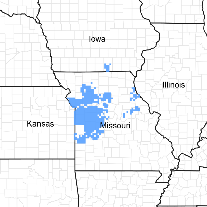
Figure 1. Mapped extent
Areas shown in blue indicate the maximum mapped extent of this ecological site. Other ecological sites likely occur within the highlighted areas. It is also possible for this ecological site to occur outside of highlighted areas if detailed soil survey has not been completed or recently updated.
MLRA notes
Major Land Resource Area (MLRA): 109X–Iowa and Missouri Heavy Till Plain
The Iowa and Missouri Heavy Till Plain is an area of rolling hills interspersed with interfluve divides and alluvial valleys. Elevation ranges from about 660 feet (200 meters) along the lower reaches of rivers, to about 980 feet (300 meters) on stable interfluve summits in southern Iowa. Relief is about 80 to 160 feet (25 to 50 meters) between major streams and adjacent interfluve summits. Most of the till plain drains south to the Missouri River via the Grand and Chariton River systems, but the northeastern portion drains southeast to the Mississippi River. Loess caps the pre-Illinoisan aged till on interfluves, whereas the till is exposed on side slopes. Mississippian aged limestone and Pennsylvanian aged sandstone and shale crop out on lower slopes in some areas.
Classification relationships
Terrestrial Natural Community Type in Missouri (Nelson, 2010):
The reference state for this ecological site is most similar to a Sandstone/Shale Savanna.
National Vegetation Classification System Vegetation Association (NatureServe, 2010):
The reference state for this ecological site is most similar to Quercus stellata - Quercus marilandica / Schizachyrium scoparium Wooded Herbaceous Vegetation (CEGL002391).
Geographic relationship to the Missouri Ecological Classification System (Nigh & Schroeder, 2002):
This ecological site occurs in several Land Type Associations, primarily within the following Subsections:
Chariton River Hills
Grand River Hills
Ecological site concept
NOTE: This is a “provisional” Ecological Site Description (ESD) that is under development. It contains basic ecological information that can be used for conservation planning, application and land management. As additional information is collected, analyzed and reviewed, this ESD will be refined and published as “Approved”.
Interbedded Sedimentary Upland Savannas are in the southwestern part of the MLRA and on similar landscapes south of the Missouri River, and in south-central Iowa. This ecological site is on Pennsylvanian aged sediments that are typically interbedded shale, sandstone, siltstone and limestone. Soils are moderately deep to deep over interbedded sedimentary bedrock, and typically have sedimentary fragments in clayey subsoils. The reference plant community is savanna with scattered bur oak, swamp white oak, post oak, American hazelnut, prairie willow and American plum, shrubs, and a ground flora of grasses such as big bluestem, little bluestem, Indiangrass, switch grass, and eastern gamagrass, and a wide variety of prairie wildflowers.
Associated sites
| R109XY012MO |
Interbedded Sedimentary Backslope Savanna Sedimentary Interbedded Backslope Savannas are downslope, on steep lower backslopes. |
|---|---|
| F109XY004MO |
Loamy Upland Drainageway Woodland Loamy Upland Drainageway Woodlands and other floodplain ecological sites are downslope. |
| R109XY002MO |
Loess Upland Prairie Loess Upland Prairies are upslope, on summits and shoulders. |
| R109XY046MO |
Till Upland Savanna Till Upland Savannas are upslope, on gently sloping upper backslopes. |
Similar sites
| R109XY012MO |
Interbedded Sedimentary Backslope Savanna Interbedded Sedimentary Backslope Savannas are similar in composition and structure and are usually adjacent to Interbedded Sedimentary Upland Savannas but occur lower on the landscape and are generally less productive. |
|---|
Table 1. Dominant plant species
| Tree |
(1) Quercus macrocarpa |
|---|---|
| Shrub |
(1) Amorpha canescens |
| Herbaceous |
(1) Schizachyrium scoparium |
Physiographic features
This site is on upland summits, shoulders and backslopes with slopes of 2 to 14 percent. The site generates runoff to adjacent, downslope ecological sites. This site does not flood.
The following figure (adapted from Preston, 1986) shows the typical landscape position of this ecological site, and landscape relationships among the major ecological sites of the uplands. The site is within the area labeled “3”, and is typically downslope from Till Upland Savanna or Loess Upland Prairie ecological sites. In most areas, Upland Drainageway or Floodplain ecological sites are directly downslope.
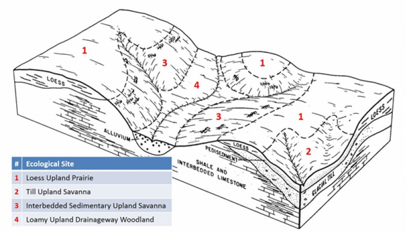
Figure 2. Landscape relationships for this ecological site
Table 2. Representative physiographic features
| Landforms |
(1)
Ridge
(2) Hill (3) Interfluve |
|---|---|
| Flooding frequency | None |
| Ponding frequency | None |
| Elevation | 600 – 1,105 ft |
| Slope | 2 – 14% |
| Water table depth | 6 – 48 in |
| Aspect | Aspect is not a significant factor |
Climatic features
The Iowa and Missouri Heavy Till Plain MLRA has a continental type of climate marked by strong seasonality. In winter, dry-cold air masses, unchallenged by any topographic barriers, periodically swing south from the northern plains and Canada. If they invade reasonably humid air, snowfall and rainfall result. In summer, moist, warm air masses, equally unchallenged by topographic barriers, swing north from the Gulf of Mexico and can produce abundant amounts of rain, either by fronts or by convectional processes. In some summers, high pressure stagnates over the region, creating extended droughty periods. Spring and fall are transitional seasons when abrupt changes in temperature and precipitation may occur due to successive, fast-moving fronts separating contrasting air masses.
This MLRA experiences small regional differences in climates that grade inconspicuously into each other. The basic gradient for most climatic characteristics is along a line from north to south. Both mean annual temperature and precipitation exhibit fairly minor gradients along this line. Mean January minimum temperature follows the north-to-south gradient. However, mean July maximum temperature shows hardly any geographic variation in the region. Mean July maximum temperatures have a range of only two to three degrees across the region.
Mean annual precipitation varies along the same gradient as temperature – lower annual precipitation in the north, higher in the south. Seasonality in precipitation is very pronounced due to strong continental influences. June precipitation, for example, averages four to five times greater than January precipitation. During years when precipitation comes in a fairly normal manner, moisture is stored in the top layers of the soil during the winter and early spring, when evaporation and transpiration are low. During the summer months the loss of water by evaporation and transpiration is high, and if rainfall fails to occur at frequent intervals, drought will result. Drought directly influences ecological communities by limiting water supplies, especially at times of high temperatures and high evaporation rates. Drought indirectly affects ecological communities by increasing plant and animal susceptibility to the probability and severity of fire. Frequent fires encourage the development of grass/forb dominated communities and understories.
Superimposed upon the basic MLRA climatic patterns are local topographic influences that create topoclimatic, or microclimatic variations. For example, air drainage at nighttime may produce temperatures several degrees lower in valley bottoms than on side slopes. At critical times during the year, this phenomenon may produce later spring or earlier fall freezes in valley bottoms. Slope orientation is an important topographic influence on climate. Summits and south-and-west-facing slopes are regularly warmer and drier, supporting more grass dominated communities than adjacent north- and-east-facing slopes that are cooler and moister that support more woody dominated communities. Finally, the cooler microclimate within a canopied forest is measurably different from the climate of a more open and warmer grassland or savanna area.
Source: University of Missouri Climate Center - http://climate.missouri.edu/climate.php; Land Resource Regions and Major Land Resource Areas of the United States, the Caribbean, and the Pacific Basin, United States Department of Agriculture Handbook 296 - http://soils.usda.gov/survey/geography/mlra/
Table 3. Representative climatic features
| Frost-free period (characteristic range) | 137-149 days |
|---|---|
| Freeze-free period (characteristic range) | 167-183 days |
| Precipitation total (characteristic range) | 38-40 in |
| Frost-free period (actual range) | 135-154 days |
| Freeze-free period (actual range) | 160-184 days |
| Precipitation total (actual range) | 38-41 in |
| Frost-free period (average) | 143 days |
| Freeze-free period (average) | 174 days |
| Precipitation total (average) | 39 in |
Figure 3. Monthly precipitation range
Figure 4. Monthly minimum temperature range
Figure 5. Monthly maximum temperature range
Figure 6. Monthly average minimum and maximum temperature
Figure 7. Annual precipitation pattern
Figure 8. Annual average temperature pattern
Climate stations used
-
(1) CENTERVILLE [USC00131354], Centerville, IA
-
(2) KEARNEY 3E [USC00234382], Kearney, MO
-
(3) HAMILTON 2W [USC00233568], Hamilton, MO
Influencing water features
This ecological site is not influenced by wetland or riparian water features. However, seeps may occur in headslope positions, particularly in the spring, and following heavy rainfall events. These seeps are source areas for first-order ephemeral streams, typically within Upland Drainageway ecological sites downslope. Where present, these headslope seeps are in the Slope wetlands class of the Hydrogeomorphic (HGM) classification system (Brinson, 1993).
Soil features
These soils are underlain with interbedded sedimentary bedrock at 20 to 60 inches (51 to 102 centimeters) deep. The soils were formed under prairie vegetation, and have dark, organic-rich surface horizons. Parent material is slope alluvium and residuum weathered from interbedded shale, sandstone, siltstone and limestone, overlying sedimentary bedrock. They have silty clay loam or silt loam surface layers. Subsoils are silty clay loam to silty clay. Soils in areas with interbedded sandstone have more sand in the subsoil. Most of these soils are affected by seasonal wetness in spring months. Soil series associated with this site include Dawn, Newcomer, Sampsel and Snead.
Table 4. Representative soil features
| Parent material |
(1)
Residuum
–
limestone, sandstone, and shale
|
|---|---|
| Surface texture |
(1) Silty clay loam (2) Silty clay |
| Family particle size |
(1) Clayey |
| Drainage class | Poorly drained to moderately well drained |
| Permeability class | Very slow to slow |
| Soil depth | 20 – 72 in |
| Surface fragment cover <=3" | 3% |
| Surface fragment cover >3" | 10% |
| Available water capacity (0-40in) |
3 – 6 in |
| Calcium carbonate equivalent (0-40in) |
Not specified |
| Electrical conductivity (0-40in) |
2 mmhos/cm |
| Sodium adsorption ratio (0-40in) |
Not specified |
| Soil reaction (1:1 water) (0-40in) |
5.2 – 7.8 |
| Subsurface fragment volume <=3" (Depth not specified) |
10% |
| Subsurface fragment volume >3" (Depth not specified) |
5% |
Ecological dynamics
Information contained in this section was developed using historical data, professional experience, field reviews, and scientific studies. The information presented is representative of very complex vegetation communities. Key indicator plants, animals and ecological processes are described to help inform land management decisions. Plant communities will differ across the MLRA because of the naturally occurring variability in weather, soils, and aspect. The Reference Plant Community is not necessarily the management goal. The species lists are representative and are not botanical descriptions of all species occurring, or potentially occurring, on this site. They are not intended to cover every situation or the full range of conditions, species, and responses for the site.
The reference plant community is characterized as an upland savanna unit dominated by little and big bluestem, Indian grass, sideoats grama, and a wide variety of prairie wildflowers. Bur oak, swamp white oak, post oak, and American plum occurred as widely scattered individuals across the savanna landscape.
Located within a matrix of low relief prairie, this ecological site still burned every 1 to 3 years. Fire removed dead plant litter and provided room for a lush growth of prairie vegetation. Fire also kept woody species at bay. Grazing by native large herbivores, such as bison, elk, and white-tailed deer, also impacted these sites. Their activities altered the composition, fuel loads and structure of the vegetation, creating a diversity of structure and composition. The partially wooded draws would have burned less intensely and less frequently. During fire free intervals woody species would have increased in abundance and spread out onto the prairie.
These sites are moderately productive. Today, Interbedded Sedimentary Upland Savannas are nearly extirpated from the region as the former prairies and savannas have been converted to intensive agriculture. A few known remnants exist but are degraded by fire suppression and grazing by domestic livestock. While re-establishing prairie and savanna on converted agriculture sites is beneficial to wildlife, restoration to the reference state from agricultural land is a long term proposition with uncertain outcomes.
A State and Transition Diagram follows. Detailed descriptions of each state, transition, plant community, and pathway follow the model. This model is based on available experimental research, field observations, professional consensus, and interpretations. It is likely to change as knowledge increases.
State and transition model
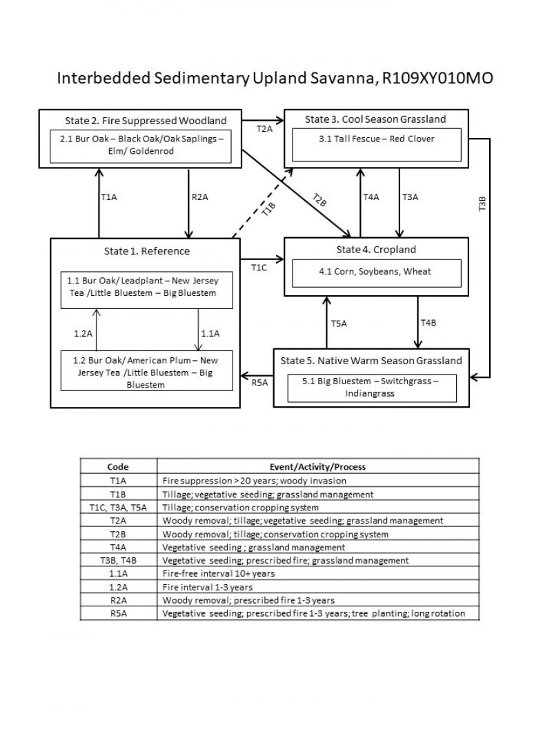
Figure 9. State and transition diagram for this ecological site
More interactive model formats are also available.
View Interactive Models
More interactive model formats are also available.
View Interactive Models
Click on state and transition labels to scroll to the respective text
Ecosystem states
States 1 and 5 (additional transitions)
State 2 submodel, plant communities
State 3 submodel, plant communities
State 4 submodel, plant communities
State 5 submodel, plant communities
State 1
Reference
This state is native oak savanna dominated by prairie cordgrass, big bluestem and a wide variety of prairie forbs. This state occurs on level to gently sloping soils. Bur oak, swamp white oak, post oak, elm, American hazelnut, prairie willow and wild plum occurred in small groves or as scattered individuals across the prairie landscape. Two phases can occur that will transition back and forth depending on fire frequencies. Longer fire free intervals will allow woody species to increase such as prairie willow, dogwoods and wild plum. When fire intervals shorten these woody species will decrease. This state is extinct. All former reference states have been converted to cool season grassland and intensive agriculture cropland or reverted to a woodland community.
Dominant plant species
-
bur oak (Quercus macrocarpa), tree
-
leadplant (Amorpha canescens), shrub
-
New Jersey tea (Ceanothus americanus), shrub
-
American plum (Prunus americana), shrub
-
little bluestem (Schizachyrium), other herbaceous
-
big bluestem (Andropogon gerardii), other herbaceous
Community 1.1
Bur Oak/ Lead Plant – New Jersey Tea /Little Bluestem – Big Bluestem
This phase is a savanna dominated by little bluestem, big bluestem and a wide variety of prairie wildflowers. Bur oak, post oak, swamp white oak, American hazelnut, lead plant and New Jersey tea occur in small groves or as scattered individuals across the open landscape.
Forest overstory. The Forest Overstory Species list is based on commonly occurring species listed in Nelson (2010).
Forest understory. The Forest Understory list is based on commonly occurring species listed in Nelson (2010).
Dominant plant species
-
bur oak (Quercus macrocarpa), tree
-
leadplant (Amorpha canescens), shrub
-
New Jersey tea (Ceanothus americanus), shrub
-
little bluestem (Schizachyrium), other herbaceous
-
big bluestem (Andropogon gerardii), other herbaceous
Community 1.2
Bur Oak/ Wild Plum – New Jersey Tea /Little Bluestem – Big Bluestem
This phase is similar to community phase 1.1 but oaks and shrubs are increasing due to longer periods of fire suppression. Some displacement of grasses and forbs may be occurring due to shading and competition from the increased canopy cover.
Dominant plant species
-
bur oak (Quercus macrocarpa), tree
-
American plum (Prunus americana), shrub
-
New Jersey tea (Ceanothus americanus), shrub
-
little bluestem (Schizachyrium), other herbaceous
-
big bluestem (Andropogon gerardii), other herbaceous
Pathway 1.1A
Community 1.1 to 1.2
Fire-free interval 10+ years
Pathway 1.2A
Community 1.2 to 1.1
Fire interval 1-3 years
State 2
Fire Suppressed Woodland
Degraded reference states that have experienced fire suppression and woody invasion for 20 or more years will transition to this state. With fire suppression, woody species such as bur oak, post oak and swamp white oak will begin to increase transitioning this state from a savanna to a woodland. Native herbaceous ground cover will also decrease.
Dominant plant species
-
bur oak (Quercus macrocarpa), tree
-
black oak (Quercus velutina), tree
-
oak (Quercus), shrub
-
elm (Ulmus), shrub
-
goldenrod (Oligoneuron), other herbaceous
Community 2.1
Bur Oak – Swamp White Oak/Oak Saplings – Elm/ Goldenrod
Dominant plant species
-
bur oak (Quercus macrocarpa), tree
-
black oak (Quercus velutina), tree
-
oak (Quercus), shrub
-
goldenrod (Oligoneuron), other herbaceous
State 3
Cool Season Grassland
Conversion of other states to non-native cool season species such as tall fescue and red clover has been common in this area. Occasionally, these pastures will have scattered bur oaks and/or swamp white oak. Long term uncontrolled grazing and a lack of grassland management can cause significant soil erosion and compaction and increases in less productive species such as Kentucky bluegrass and weedy forbs such as ironweed. A return to the reference state may be impossible, requiring a very long term series of management options.
Dominant plant species
-
tall fescue (Schedonorus arundinaceus), other herbaceous
-
red clover (Trifolium pratense), other herbaceous
Community 3.1
Tall Fescue – Red Clover
Dominant plant species
-
tall fescue (Schedonorus arundinaceus), other herbaceous
-
red clover (Trifolium pratense), other herbaceous
State 4
Cropland
This is the dominant State that exists currently with intensive cropping of corn, wheat and soybeans occurring. Some conversion to cool season hayland occurs for a limited period of time before transitioning back to cropland. Limited acres are sometimes converted to native warm season grassland through federal set-aside programs.
Community 4.1
Corn, Soybeans, Wheat
Dominant plant species
State 5
Native Warm Season Grassland
Conversion from the Cool Season Grassland (State 3) or the Cropland (State 4) to this state is increasing due to renewed interest in warm season grasses as a supplement to cool season grazing systems or as a native restoration activity. This state can be transformed back to a Reference State. Substantial restoration time and management inputs will still be needed.
Dominant plant species
-
big bluestem (Andropogon gerardii), other herbaceous
-
switchgrass (Panicum virgatum), other herbaceous
-
Indiangrass (Sorghastrum), other herbaceous
Community 5.1
Big Bluestem – Switchgrass – Indiangrass
Transition T1A
State 1 to 2
Fire suppression >20 years; woody invasion
Transition T1B
State 1 to 3
Tillage; vegetative seeding; grassland management
Transition T1C
State 1 to 4
Tillage; conservation cropping system
Restoration pathway R2A
State 2 to 1
Woody removal; prescribed fire 1-3 years
Transition T2A
State 2 to 3
Woody removal; tillage; vegetative seeding; grassland management
Transition T3A
State 3 to 4
Tillage; conservation cropping system
Transition T3B
State 3 to 5
Vegetative seeding; prescribed fire; grassland management
Restoration pathway T4A
State 4 to 3
Vegetative seeding; grassland management
Transition T4B
State 4 to 5
Vegetative seeding; prescribed fire; grassland management
Restoration pathway R5A
State 5 to 1
Vegetative seeding; prescribed fire 1-3 years; tree planting; long rotation
Restoration pathway T4B
State 5 to 4
Vegetative seeding; prescribed fire; grassland management
Additional community tables
Table 5. Community 1.1 forest overstory composition
| Common name | Symbol | Scientific name | Nativity | Height (ft) | Canopy cover (%) | Diameter (in) | Basal area (square ft/acre) |
|---|---|---|---|---|---|---|---|
|
Tree
|
|||||||
| swamp white oak | QUBI | Quercus bicolor | Native | – | 5–10 | – | – |
| bur oak | QUMA2 | Quercus macrocarpa | Native | – | 5–10 | – | – |
| post oak | QUST | Quercus stellata | Native | – | 5–10 | – | – |
Table 6. Community 1.1 forest understory composition
| Common name | Symbol | Scientific name | Nativity | Height (ft) | Canopy cover (%) | |
|---|---|---|---|---|---|---|
|
Grass/grass-like (Graminoids)
|
||||||
| little bluestem | SCSC | Schizachyrium scoparium | Native | – | 30–50 | |
| big bluestem | ANGE | Andropogon gerardii | Native | – | 30–50 | |
| sideoats grama | BOCU | Bouteloua curtipendula | Native | – | 10–20 | |
| Indiangrass | SONU2 | Sorghastrum nutans | Native | – | 10–20 | |
| eastern gamagrass | TRDA3 | Tripsacum dactyloides | Native | – | 5–10 | |
| switchgrass | PAVI2 | Panicum virgatum | Native | – | 5–10 | |
| Mead's sedge | CAME2 | Carex meadii | Native | – | 5–10 | |
| Bush's sedge | CABU5 | Carex bushii | Native | – | 5–10 | |
| slender spikerush | ELTET | Eleocharis tenuis var. tenuis | Native | – | 5–10 | |
|
Forb/Herb
|
||||||
| wild quinine | PAIN3 | Parthenium integrifolium | Native | – | 5–20 | |
| butterfly milkweed | ASTU | Asclepias tuberosa | Native | – | 5–20 | |
| prairie blazing star | LIPY | Liatris pycnostachya | Native | – | 5–20 | |
| Missouri goldenrod | SOMI2 | Solidago missouriensis | Native | – | 5–20 | |
| ashy sunflower | HEMO2 | Helianthus mollis | Native | – | 5–20 | |
| button eryngo | ERYU | Eryngium yuccifolium | Native | – | 5–20 | |
| prairie milkweed | ASSU3 | Asclepias sullivantii | Native | – | 5–20 | |
| longbract wild indigo | BABR2 | Baptisia bracteata | Native | – | 5–20 | |
| wholeleaf rosinweed | SIIN2 | Silphium integrifolium | Native | – | 5–20 | |
| purple milkwort | POSA3 | Polygala sanguinea | Native | – | 5–10 | |
| white wild indigo | BAAL | Baptisia alba | Native | – | 5–10 | |
| Illinois bundleflower | DEIL | Desmanthus illinoensis | Native | – | 5–10 | |
| Culver's root | VEVI4 | Veronicastrum virginicum | Native | – | 5–10 | |
|
Shrub/Subshrub
|
||||||
| leadplant | AMCA6 | Amorpha canescens | Native | – | 5–20 | |
| prairie willow | SAHU2 | Salix humilis | Native | – | 5–10 | |
| American plum | PRAM | Prunus americana | Native | – | 5–10 | |
| Carolina rose | ROCA4 | Rosa carolina | Native | – | 5–10 | |
| New Jersey tea | CEAM | Ceanothus americanus | Native | – | 5–10 | |
Interpretations
Animal community
Wildlife
Prairie Phase:
Game species that utilize this ecological site include:
Northern Bobwhite will utilize this ecological site for food (seeds, insects) and cover needs (escape, nesting and roosting cover).
Cottontail rabbits will utilize this ecological site for food (seeds, soft mast) and cover needs.
Turkey will utilize this ecological site for food (seeds, green browse, soft mast, insects) and nesting and brood-rearing cover. Turkey poults feed heavily on insects provided by this site type.
White-tailed Deer will utilize this ecological site for browse (plant leaves in the growing season, seeds and soft mast in the fall/winter). This site type also can provide escape cover.
Bird species associated with this ecological site’s reference state condition:
Breeding birds as related to vegetation structure (related to time since fire, grazing, haying, and mowing):
Vegetation Height Short ( 0.5 meter, low litter levels, bare ground visible):
Grasshopper Sparrow, Horned Lark, Upland Sandpiper, Greater Prairie Chicken, Northern Bobwhite
Mid-Vegetation Height (0.5 – 1 meter, moderate litter levels, some bare ground visible):
Eastern Meadowlark, Dickcissel, Field Sparrow, Upland Sandpiper, Greater Prairie Chicken, Northern Bobwhite, Eastern Kingbird, Bobolink, Lark Sparrow
Tall Vegetation Height (> 1 meter, moderate-high litter levels, little bare ground visible):
Henslow’s Sparrow, Dickcissel, Greater Prairie Chicken, Field Sparrow, Northern Bobwhite, Sedge Wren, Northern Harrier
Brushy – Mix of grasses, forbs, native shrubs (e.g., Rhus copallina, Prunus americana, Rubus spp., Rosa carolina) and small trees (e.g., Cornus racemosa): Bell’s Vireo, Yellow-Breasted Chat, Loggerhead Shrike, Brown Thrasher, Common Yellowthroat
Winter Resident: Short-Eared Owl, Le Conte’s Sparrow
Amphibian and reptile species associated with this ecological site’s reference state condition: prairies with or nearby to fishless ponds/pools (may be ephemeral) may have Eastern Tiger Salamander (Ambystoma tigrinum tigrinum) and Western Chorus Frog (Pseudacris triseriata triseriata); prairies with crawfish burrows may have Northern Crawfish Frog (Rana areolata circulosa); other species include Northern Prairie Skink (Eumeces septentrionalis septentrionalis), Ornate Box Turtle (Terrapene ornata ornata), Western Slender Glass Lizard (Ophisaurus attenuatus attenuatus), Eastern Yellow-bellied Racer (Coluber constrictor flaviventris), Prairie Ring-necked Snake (Diadophis punctatus arnyi), and Bullsnake (Pituophis catenifer sayi).
Small mammals associated with this ecological site’s reference state condition: Least Shrew (Cryptotis parva), Franklin’s Ground Squirrel (Spermophilus franklinii), Plains Pocket Gopher (Geomys bursarius), Prairie Vole (Microtus ochrogaster), Southern Bog Lemming (Synaptomys cooperi), Meadow Jumping Mouse (Zapus hudsonius), Thirteen-lined Ground Squirrel (Spermophilus tridecemlineatus) and Badger (Taxidea taxus).
Invertebrates:
Many native insect species are likely associated with this ecological site, especially native bees, ants, beetles, butterflies and moths, and crickets, grasshoppers and katydids. However information on these groups is often lacking enough resolution to assign them to individual ecological sites.
Insect species known to be associated with this ecological site’s reference state condition: Regal Fritillary butterfly (Speyeria idalia) whose larvae feed primarily on native prairie violets (Viola pedata, V. pedatifida, and V. sagittata); Mottled Dusky Wing butterfly (Erynnis martialis), Golden Byssus butterfly (Problema byssus kumskaka), Delaware Skipper butterfly (Atryone logan logan), and Crossline Skipper butterfly (Polites origenes). The larvae of the moth Eucosma bipunctella bore into compass plant (Silphium laciniatum) roots and feed and the larvae of the moth Eucosma giganteana bore into a number of Silphium species roots and feed. Native bees, important pollinators, that may be associated with this ecological site’s reference condition include: Colletes brevicornis, Andrena beameri, A. helianthiformis, Protandrena rudbeckiae, Halictus parallelus, Lasioglossum albipennis, L. coreopsis, L. disparilis, L. nymphaereum, Ashmeadiella bucconis, Megachile addenda, Anthidium psoraleae, Eucera hamata, Melissodes coloradensis, M. coreopsis, and M. vernoniae. The Short-winged Katydid (Amblycorypha parvipennis), Green Grasshopper (Hesperotettix speciosus) and Two-voiced Conehead katydid (Neoconcephalus bivocatus) are possible orthopteran associates of this ecological site.
Other invertebrate associates include the Grassland Crayfish (Procambarus gracilis).
Savanna Phase:
Oaks and hickories provide an important food source for many animals including White-tailed Deer, Wild Turkey, and Fox Squirrel.
Both snags and live cavity or den trees provide important food and cover for vertebrate wildlife. Snags are also very important to invertebrate species. Fox Squirrel, Red-headed Woodpecker and Eastern Bluebird utilize snags and den trees for foraging, nesting or shelter. “Wolf” trees are a particularly valuable type of live cavity tree. These large diameter, often open-grown, old-ages, hollow trees provide both cavities for wildlife and usually hard or soft mast food sources. Large diameter snags and den trees are particularly important wildlife habitat features to retain.
Game species that utilize this ecological site include:
Northern Bobwhite will utilize this ecological site for food (seeds, insects) and cover needs (escape, nesting and roosting cover).
Cottontail rabbits will utilize this ecological site for food (seeds, soft mast) and cover needs.
Turkey will utilize this ecological site for food (seeds, green browse, soft mast, insects) and nesting and brood-rearing cover. Turkey poults feed heavily on insects provided by this site type.
White-tailed Deer will utilize this ecological site for browse (plant leaves in the growing season, seeds and soft mast in the fall/winter). This site type also can provide escape cover.
Bird species associated with this ecological site’s reference state condition:
Breeding birds: Northern Bobwhite, Eastern Kingbird, Eastern Bluebird, Brown Thrasher, White-eyed Vireo, Prairie Warbler, Field Sparrow, Eastern Towhee, Red-headed Woodpecker, Great Crested Flycatcher, Loggerhead Shrike
Winter resident: American Tree Sparrow, Harris’ Sparrow
Amphibian and reptile species likely associated with this ecological site’s reference state condition: Ornate Box Turtle (Terrapene ornata ornata), Northern Fence Lizard (Sceloporus undulates hyacinthinus), Five-lined Skink (Eumeces fasciatus), Western Slender Glass Lizard (Ophisaurus attenuatus attenuatus), Eastern Yellow-bellied Racer (Coluber constrictor flaviventris), Prairie Ring-necked Snake (Diadophis punctatus arnyi), and Rough Green Snake (Opheodrys aestivus aestivus). Sites containing or nearby to fishless or ephemeral ponds/pools may support the Eastern Tiger Salamander (Ambystoma tigrinum tigrinum).
Small mammals likely associated with this ecological site’s reference state condition: Fox Squirrel (Sciurus niger), Woodland Vole (Microtus pinetorum), Least Shrew (Cryptotis parva), and Indiana Bat (Myotis sodalis). Indiana bats utilize suitable live, dying or dead roost trees for summer habitat and raising young. Suitable roost trees typically have exfoliating or flaking bark and are larger in diameter.
Invertebrates – Many native insect species are likely associated with this phase of this ecological site’s reference state condition, especially native bees, ants, beetles, butterflies and moths, and crickets, grasshoppers and katydids. However we don’t have enough information on these groups to assign them to this phase of this ecological site’s reference state condition at this time.
Game species that utilize this ecological site include:
Northern Bobwhite will utilize this ecological site for food (seeds, insects) and cover needs (escape, nesting and roosting cover).
Cottontail rabbits will utilize this ecological site for food (seeds, soft mast) and cover needs.
Turkey will utilize this ecological site for food (seeds, green browse, soft mast, insects) and nesting and brood-rearing cover. Turkey poults feed heavily on insects provided by this site type.
White-tailed Deer will utilize this ecological site for browse (plant leaves in the growing season, seeds and soft mast in the fall/winter). This site type also can provide escape cover.
Bird species associated with this ecological site’s reference state condition:
Breeding birds as related to vegetation structure (related to time since fire, grazing, haying, and mowing):
Vegetation Height Short ( 0.5 meter, low litter levels, bare ground visible):
Grasshopper Sparrow, Horned Lark, Upland Sandpiper, Greater Prairie Chicken, Northern Bobwhite
Mid-Vegetation Height (0.5 – 1 meter, moderate litter levels, some bare ground visible):
Eastern Meadowlark, Dickcissel, Field Sparrow, Upland Sandpiper, Greater Prairie Chicken, Northern Bobwhite, Eastern Kingbird, Bobolink, Lark Sparrow
Tall Vegetation Height (> 1 meter, moderate-high litter levels, little bare ground visible):
Henslow’s Sparrow, Dickcissel, Greater Prairie Chicken, Field Sparrow, Northern Bobwhite, Sedge Wren, Northern Harrier
Brushy – Mix of grasses, forbs, native shrubs (e.g., Rhus copallina, Prunus americana, Rubus spp., Rosa carolina) and small trees (e.g., Cornus racemosa): Bell’s Vireo, Yellow-Breasted Chat, Loggerhead Shrike, Brown Thrasher, Common Yellowthroat
Winter Resident: Short-Eared Owl, Le Conte’s Sparrow
Amphibian and reptile species associated with this ecological site’s reference state condition: prairies with or nearby to fishless ponds/pools (may be ephemeral) may have Eastern Tiger Salamander (Ambystoma tigrinum tigrinum) and Western Chorus Frog (Pseudacris triseriata triseriata); prairies with crawfish burrows may have Northern Crawfish Frog (Rana areolata circulosa); other species include Northern Prairie Skink (Eumeces septentrionalis septentrionalis), Ornate Box Turtle (Terrapene ornata ornata), Western Slender Glass Lizard (Ophisaurus attenuatus attenuatus), Eastern Yellow-bellied Racer (Coluber constrictor flaviventris), Prairie Ring-necked Snake (Diadophis punctatus arnyi), and Bullsnake (Pituophis catenifer sayi).
Small mammals associated with this ecological site’s reference state condition: Least Shrew (Cryptotis parva), Franklin’s Ground Squirrel (Spermophilus franklinii), Plains Pocket Gopher (Geomys bursarius), Prairie Vole (Microtus ochrogaster), Southern Bog Lemming (Synaptomys cooperi), Meadow Jumping Mouse (Zapus hudsonius), Thirteen-lined Ground Squirrel (Spermophilus tridecemlineatus) and Badger (Taxidea taxus).
Invertebrates:
Many native insect species are likely associated with this ecological site, especially native bees, ants, beetles, butterflies and moths, and crickets, grasshoppers and katydids. However information on these groups is often lacking enough resolution to assign them to individual ecological sites.
Insect species known to be associated with this ecological site’s reference state condition: Regal Fritillary butterfly (Speyeria idalia) whose larvae feed primarily on native prairie violets (Viola pedata, V. pedatifida, and V. sagittata); Mottled Dusky Wing butterfly (Erynnis martialis), Golden Byssus butterfly (Problema byssus kumskaka), Delaware Skipper butterfly (Atryone logan logan), and Crossline Skipper butterfly (Polites origenes). The larvae of the moth Eucosma bipunctella bore into compass plant (Silphium laciniatum) roots and feed and the larvae of the moth Eucosma giganteana bore into a number of Silphium species roots and feed. Native bees, important pollinators, that may be associated with this ecological site’s reference condition include: Colletes brevicornis, Andrena beameri, A. helianthiformis, Protandrena rudbeckiae, Halictus parallelus, Lasioglossum albipennis, L. coreopsis, L. disparilis, L. nymphaereum, Ashmeadiella bucconis, Megachile addenda, Anthidium psoraleae, Eucera hamata, Melissodes coloradensis, M. coreopsis, and M. vernoniae. The Short-winged Katydid (Amblycorypha parvipennis), Green Grasshopper (Hesperotettix speciosus) and Two-voiced Conehead katydid (Neoconcephalus bivocatus) are possible orthopteran associates of this ecological site.
Other invertebrate associates include the Grassland Crayfish (Procambarus gracilis).
(This section developed by Mike Leahy, Natural Areas Coordinator, Missouri Department of Conservation, 2013; references for this section include: Easterla, 1962; Fitzgerald and Pashley. 2000b; Heitzman and Heitzman 1996; Jacobs 2001; Johnson 2000; Pitts and McGuire 2000; Schwartz and others 2001)
Other information
Forestry
Management: This ecological site is not recommended for traditional timber management activity. Historically this site was dominated by a ground cover of native prairie grasses and forbs. Scattered open grown trees were present. Alternative states may be suitable for non-traditional forestry uses such as windbreaks, environmental plantings, alley cropping (a method of planting, in which rows of trees or shrubs are interspersed with rows of crops) or woody bio-fuels.
Supporting information
Inventory data references
1 alternate state plot - Dorsett Hill Prairie CA – Snead soil
Other references
Brinson, M.M. 1993. A hydrogeomorphic classification for wetlands. Technical Report WRP-DE-4, U.S. Army Corps of Engineers, Engineer Waterways Experiment Station, Vicksburg, MS.
Fitzgerald, J.A. and D.N. Pashley. 2000b. Partners in Flight bird conservation plan for the Dissected Till Plains. American Bird Conservancy.
Heitzman, J.R. and J.E. Heitzman. 1996. Butterflies and moths of Missouri. 2nd ed. Missouri Department of Conservation, Jefferson City.
Jacobs, B. 2001. Birds in Missouri. Missouri Department of Conservation, Jefferson City.
Johnson, T.R. 2000. The amphibians and reptiles of Missouri. 2nd ed. Missouri Department of Conservation, Jefferson City.
NatureServe. 2010. Vegetation Associations of Missouri (revised). NatureServe, St. Paul, Minnesota.
Nelson, Paul W. 2010. The Terrestrial Natural Communities of Missouri. Missouri Department of Conservation, Jefferson City, Missouri.
Nigh, Timothy A., & Walter A. Schroeder. 2002. Atlas of Missouri Ecoregions. Missouri Department of Conservation, Jefferson City, Missouri.
Pitts, D.E. and W.D. McGuire. 2000. Wildlife management for Missouri landowners. 3rd ed. Missouri Department of Conservation, Jefferson City.
Preston, George D. 1986. Soil Survey of Clay and Ray Counties, Missouri. U.S. Dept. of Agric. Soil Conservation Service.
Schwartz, C.W., E.R. Schwartz and J.J. Conley. 2001. The wild mammals of Missouri. University of Missouri Press, Columbia and Missouri Department of Conservation, Jefferson City.
Contributors
Doug Wallace
Fred Young
Approval
Suzanne Mayne-Kinney, 7/02/2024
Acknowledgments
This site was originally approved on 07/28/2015 for publication.
Rangeland health reference sheet
Interpreting Indicators of Rangeland Health is a qualitative assessment protocol used to determine ecosystem condition based on benchmark characteristics described in the Reference Sheet. A suite of 17 (or more) indicators are typically considered in an assessment. The ecological site(s) representative of an assessment location must be known prior to applying the protocol and must be verified based on soils and climate. Current plant community cannot be used to identify the ecological site.
| Author(s)/participant(s) | |
|---|---|
| Contact for lead author | |
| Date | 07/03/2024 |
| Approved by | Suzanne Mayne-Kinney |
| Approval date | |
| Composition (Indicators 10 and 12) based on | Annual Production |
Indicators
-
Number and extent of rills:
-
Presence of water flow patterns:
-
Number and height of erosional pedestals or terracettes:
-
Bare ground from Ecological Site Description or other studies (rock, litter, lichen, moss, plant canopy are not bare ground):
-
Number of gullies and erosion associated with gullies:
-
Extent of wind scoured, blowouts and/or depositional areas:
-
Amount of litter movement (describe size and distance expected to travel):
-
Soil surface (top few mm) resistance to erosion (stability values are averages - most sites will show a range of values):
-
Soil surface structure and SOM content (include type of structure and A-horizon color and thickness):
-
Effect of community phase composition (relative proportion of different functional groups) and spatial distribution on infiltration and runoff:
-
Presence and thickness of compaction layer (usually none; describe soil profile features which may be mistaken for compaction on this site):
-
Functional/Structural Groups (list in order of descending dominance by above-ground annual-production or live foliar cover using symbols: >>, >, = to indicate much greater than, greater than, and equal to):
Dominant:
Sub-dominant:
Other:
Additional:
-
Amount of plant mortality and decadence (include which functional groups are expected to show mortality or decadence):
-
Average percent litter cover (%) and depth ( in):
-
Expected annual annual-production (this is TOTAL above-ground annual-production, not just forage annual-production):
-
Potential invasive (including noxious) species (native and non-native). List species which BOTH characterize degraded states and have the potential to become a dominant or co-dominant species on the ecological site if their future establishment and growth is not actively controlled by management interventions. Species that become dominant for only one to several years (e.g., short-term response to drought or wildfire) are not invasive plants. Note that unlike other indicators, we are describing what is NOT expected in the reference state for the ecological site:
-
Perennial plant reproductive capability:
Print Options
Sections
Font
Other
The Ecosystem Dynamics Interpretive Tool is an information system framework developed by the USDA-ARS Jornada Experimental Range, USDA Natural Resources Conservation Service, and New Mexico State University.
Click on box and path labels to scroll to the respective text.