Natural Resources
Conservation Service
Ecological site R109XY023MO
Shallow Limestone Backslope Glade/Woodland
Last updated: 7/02/2024
Accessed: 03/26/2026
General information
Provisional. A provisional ecological site description has undergone quality control and quality assurance review. It contains a working state and transition model and enough information to identify the ecological site.
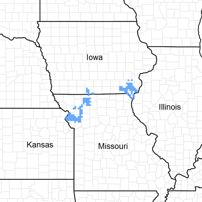
Figure 1. Mapped extent
Areas shown in blue indicate the maximum mapped extent of this ecological site. Other ecological sites likely occur within the highlighted areas. It is also possible for this ecological site to occur outside of highlighted areas if detailed soil survey has not been completed or recently updated.
MLRA notes
Major Land Resource Area (MLRA): 109X–Iowa and Missouri Heavy Till Plain
The Iowa and Missouri Heavy Till Plain is an area of rolling hills interspersed with interfluve divides and alluvial valleys. Elevation ranges from about 660 feet (200 meters) along the lower reaches of rivers, to about 980 feet (300 meters) on stable interfluve summits in southern Iowa. Relief is about 80 to 160 feet (25 to 50 meters) between major streams and adjacent interfluve summits. Most of the till plain drains south to the Missouri River via the Grand and Chariton River systems, but the northeastern portion drains southeast to the Mississippi River. Loess caps the pre-Illinoisan aged till on interfluves, whereas the till is exposed on side slopes. Mississippian aged limestone and Pennsylvanian aged sandstone and shale crop out on lower slopes in some areas.
Classification relationships
Terrestrial Natural Community Type in Missouri (Nelson, 2010):
The reference state for this ecological site is most similar to a Limestone Glade.
Missouri Department of Conservation Forest and Woodland Communities (Missouri Department of Conservation, 2006):
The reference state for this ecological site is most similar to a Limestone/Dolomite Woodland.
National Vegetation Classification System Vegetation Association (NatureServe, 2010):
The reference state for this ecological site is most similar to Schizachyrium scoparium - Bouteloua curtipendula - Rudbeckia missouriensis - Mentzelia oligosperma Wooded Herbaceous Vegetation (CEGL002251).
Geographic relationship to the Missouri Ecological Classification System (Nigh & Schroeder, 2002):
This ecological site occurs in several Land Type Associations, primarily within the following Subsections:
Grand River Hills
Loess Hills
Ecological site concept
NOTE: This is a “provisional” Ecological Site Description (ESD) that is under development. It contains basic ecological information that can be used for conservation planning, application and land management. As additional information is collected, analyzed and reviewed, this ESD will be refined and published as “Approved”.
Shallow Limestone Backslope Glade/Woodlands are in scattered locations mainly in the western and northeastern parts of the MLRA and adjacent areas. Soils are shallow to limestone bedrock. The reference plant community ranges from open areas of prairie grasses and forbs interspersed with bare bedrock and lichens, to areas with shrubs and widely scattered chinkapin oak and post oak.
Associated sites
| R109XY008MO |
Till Backslope Savanna Till Backslope Savannas are upslope, on steep lower backslopes. |
|---|---|
| F109XY030MO |
Loamy Floodplain Forest Loamy Floodplain Forests and other floodplain ecological sites are downslope. |
| R109XY046MO |
Till Upland Savanna Till Upland Savannas are upslope, on gently sloping upper backslopes. |
Similar sites
| R109XY023MO |
Shallow Limestone Backslope Glade/Woodland There are no similar ecological sites in this MLRA. |
|---|
Table 1. Dominant plant species
| Tree |
(1) Quercus muehlenbergii |
|---|---|
| Shrub |
(1) Rhus copallina |
| Herbaceous |
(1) Schizachyrium scoparium |
Physiographic features
This site is on upland backslopes with slopes of 14 to 50 percent . The site receives runoff from upslope summit and shoulder sites, and generates runoff to adjacent, downslope ecological sites. This site does not flood.
The following figure (adapted from Minor & Davis, 1983) shows the typical landscape position of this ecological site, and landscape relationships among the major ecological sites of the uplands and adjacent floodplains. The site is within the area labeled “4”, and is typically downslope from Till Upland and Backslope Savanna ecological sites. In most areas, Upland Drainageway or Terrace and Floodplain ecological sites are directly downslope.
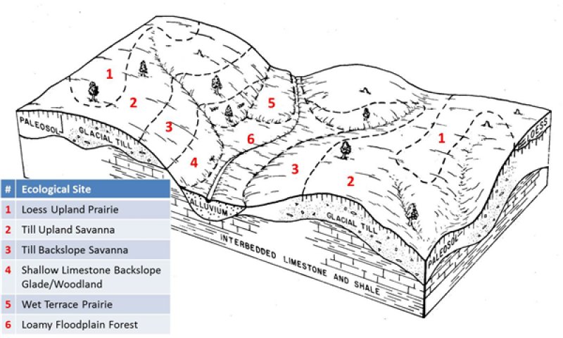
Figure 2. Landscape relationships for this ecological site
Table 2. Representative physiographic features
| Landforms |
(1)
Hillslope
|
|---|---|
| Flooding frequency | None |
| Ponding frequency | None |
| Elevation | 500 – 1,300 ft |
| Slope | 14 – 50% |
| Water table depth |
Not specified |
| Aspect | W, SE, S, SW |
Climatic features
The Iowa and Missouri Heavy Till Plain MLRA has a continental type of climate marked by strong seasonality. In winter, dry-cold air masses, unchallenged by any topographic barriers, periodically swing south from the northern plains and Canada. If they invade reasonably humid air, snowfall and rainfall result. In summer, moist, warm air masses, equally unchallenged by topographic barriers, swing north from the Gulf of Mexico and can produce abundant amounts of rain, either by fronts or by convectional processes. In some summers, high pressure stagnates over the region, creating extended droughty periods. Spring and fall are transitional seasons when abrupt changes in temperature and precipitation may occur due to successive, fast-moving fronts separating contrasting air masses.
This MLRA experiences small regional differences in climates that grade inconspicuously into each other. The basic gradient for most climatic characteristics is along a line from north to south. Both mean annual temperature and precipitation exhibit fairly minor gradients along this line. Mean January minimum temperature follows the north-to-south gradient. However, mean July maximum temperature shows hardly any geographic variation in the region. Mean July maximum temperatures have a range of only two to three degrees across the region.
Mean annual precipitation varies along the same gradient as temperature – lower annual precipitation in the north, higher in the south. Seasonality in precipitation is very pronounced due to strong continental influences. June precipitation, for example, averages four to five times greater than January precipitation. During years when precipitation comes in a fairly normal manner, moisture is stored in the top layers of the soil during the winter and early spring, when evaporation and transpiration are low. During the summer months the loss of water by evaporation and transpiration is high, and if rainfall fails to occur at frequent intervals, drought will result. Drought directly influences ecological communities by limiting water supplies, especially at times of high temperatures and high evaporation rates. Drought indirectly affects ecological communities by increasing plant and animal susceptibility to the probability and severity of fire. Frequent fires encourage the development of grass/forb dominated communities and understories.
Superimposed upon the basic MLRA climatic patterns are local topographic influences that create topoclimatic, or microclimatic variations. For example, air drainage at nighttime may produce temperatures several degrees lower in valley bottoms than on side slopes. At critical times during the year, this phenomenon may produce later spring or earlier fall freezes in valley bottoms. Slope orientation is an important topographic influence on climate. Summits and south-and-west-facing slopes are regularly warmer and drier, supporting more grass dominated communities than adjacent north- and-east-facing slopes that are cooler and moister that support more woody dominated communities. Finally, the cooler microclimate within a canopied forest is measurably different from the climate of a more open and warmer grassland or savanna area.
Source: University of Missouri Climate Center - http://climate.missouri.edu/climate.php; Land Resource Regions and Major Land Resource Areas of the United States, the Caribbean, and the Pacific Basin, United States Department of Agriculture Handbook 296 - http://soils.usda.gov/survey/geography/mlra/
Table 3. Representative climatic features
| Frost-free period (characteristic range) | 155-156 days |
|---|---|
| Freeze-free period (characteristic range) | 184-186 days |
| Precipitation total (characteristic range) | 39-40 in |
| Frost-free period (actual range) | 155-156 days |
| Freeze-free period (actual range) | 184-186 days |
| Precipitation total (actual range) | 38-41 in |
| Frost-free period (average) | 156 days |
| Freeze-free period (average) | 185 days |
| Precipitation total (average) | 40 in |
Figure 3. Monthly precipitation range
Figure 4. Monthly minimum temperature range
Figure 5. Monthly maximum temperature range
Figure 6. Monthly average minimum and maximum temperature
Figure 7. Annual precipitation pattern
Figure 8. Annual average temperature pattern
Climate stations used
-
(1) DONNELLSON [USC00132299], Donnellson, IA
-
(2) BETHANY [USC00230608], Bethany, MO
-
(3) KEARNEY 3E [USC00234382], Kearney, MO
Influencing water features
This ecological site is not influenced by wetland or riparian water features. • The water features of this upland ecological site include evapotranspiration, surface runoff, and drainage. Each water balance component fluctuates to varying extents from year-to-year. Precipitation and drainage are highly variable between years. Seasonal variability differs for each water component. Precipitation generally occurs as single day events. Evapotranspiration is lowest in the winter and peaks in the summer. The surface runoff pulse is greatly influenced by extreme events and is extenuated by the shallow soil depths.
Soil features
These soils are underlain with limestone bedrock at less than 20 inches (51 centimeters). The soils were formed under prairie vegetation, and have dark, organic-rich surface horizons. Parent material is limestone residuum. These soils are clayey and are skeletal, with high amounts of limestone gravel, channers and flagstones. They are not affected by seasonal wetness. Soil series associated with this site include Gasconade.
Table 4. Representative soil features
| Parent material |
(1)
Residuum
–
limestone
|
|---|---|
| Surface texture |
(1) Flaggy silty clay loam |
| Family particle size |
(1) Clayey |
| Drainage class | Somewhat excessively drained |
| Permeability class | Very slow to slow |
| Soil depth | 4 – 20 in |
| Surface fragment cover <=3" | 5% |
| Surface fragment cover >3" | 5 – 40% |
| Available water capacity (0-40in) |
1 – 2 in |
| Calcium carbonate equivalent (0-40in) |
Not specified |
| Electrical conductivity (0-40in) |
Not specified |
| Sodium adsorption ratio (0-40in) |
Not specified |
| Soil reaction (1:1 water) (0-40in) |
6.1 – 7.8 |
| Subsurface fragment volume <=3" (Depth not specified) |
5% |
| Subsurface fragment volume >3" (Depth not specified) |
35 – 50% |
Ecological dynamics
Information contained in this section was developed using historical data, professional experience, field reviews, and scientific studies. The information presented is representative of very complex vegetation communities. Key indicator plants, animals and ecological processes are described to help inform land management decisions. Plant communities will differ across the MLRA because of the naturally occurring variability in weather, soils, and aspect. The Reference Plant Community is not necessarily the management goal. The species lists are representative and are not botanical descriptions of all species occurring, or potentially occurring, on this site. They are not intended to cover every situation or the full range of conditions, species, and responses for the site.
Limestone glades are open, rocky areas with very shallow soils dominated by drought-adapted herbaceous flora, generally occurring on south-and west-facing slopes of otherwise wooded sites (Nelson 2010). One of the most striking aspects of limestone glades is their unique and characteristic flora. Many plants have an affinity for calcareous dolomite substrates. Glade plants in general possess many adaptations enabling them to survive in a harsh environment often subject to widely fluctuating extremes of temperature and moisture. The following conditions are general characteristic of most limestone glades (Nelson and Ladd 1983; Nelson et al. 2013):
• Calcareous limestone bedrock at or near the surface as a result of major erosional activity and resistance to weathering;
• Moderate to steep slopes in deeply dissected drainage or hilly to mountainous terrain with a southern or western exposure with intense solar radiation;
• Extremely thin soil cover interspersed with abundant rock fragments and rock outcrops;
• Exceptionally dry conditions throughout much of the growing season, although soils may be seasonally saturated in spring, winter, and fall;
• Peripheral areas and sometimes large expanses of the glades themselves characterized by a mosaic of stunted, often gnarled trees and shrubs.
Shallow Limestone Backslope Glade/Woodland ecological sites harbor a wide diversity of plants and animals. Grasses such as little bluestem, Indiangrass, and sideoats grama, are also found on upland prairies. The shallow soils of this ecological site limit the growth and abundance of trees and support the native grasses and forbs that dominate these systems. Fire played an important role in the maintenance of these systems, as well. It is likely that these sites burned at least once every five years.
These periodic fires removed the litter and stimulated the growth and flowering of the grasses and forbs. They also further limited the growth and dominance of trees, especially eastern redcedar. Fire tolerant chinquapin oak and post oak occupied islands and edges where the deeper range of the soil component occurred, creating a complex mosaic of open glade and low-density woodland. During fire-free intervals, woody species increased, but not to densities on over-grazed glades.
These sites are not productive. In the absence of fire, woody species, especially eastern redcedar, quickly occupy the site. This is especially true after grazing has reduced grass cover and exposed more surface to the dispersal of cedar seeds by birds. Once established, eastern redcedar can quickly fill in a glade/woodland system, especially if grazing has diminished the vigor of the diverse flora. Many glades have been heavily grazed and suffer substantial redcedar invasion. Removal of the eastern redcedar and the application of prescribed fire have proven to be an effect way to management these systems.
A State and Transition Diagram follows. Detailed descriptions of each state, transition, plant community, and pathway follow the model. This model is based on available experimental research, field observations, professional consensus, and interpretations. It is likely to change as knowledge increases.
State and transition model
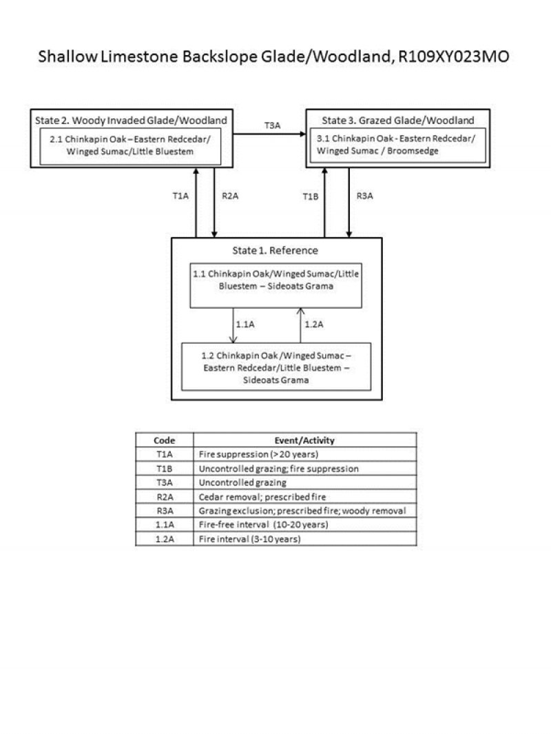
Figure 9. State and Transition Model for this ecological site.
More interactive model formats are also available.
View Interactive Models
More interactive model formats are also available.
View Interactive Models
Click on state and transition labels to scroll to the respective text
State 2 submodel, plant communities
State 3 submodel, plant communities
State 1
Reference
Glade/Woodland Reference sites harbor a wide diversity of plants and animals. Many, like little bluestem, Indian grass, and sideoats grama, are also found on upland prairies. The glade/woodland complexes range from wide open grassy areas with shallow soils and bare bedrock, to areas with widely scattered chinkapin and post oaks on locations with soil depths at the deeper extreme of the range for this soil component. On protected slopes, open woodlands with chinkapin and post oaks are more common. Here the deeper soil depth range for this soil component and protected aspects allow more woody components to dominate. As fire frequencies decrease invasion by woody species such as eastern redcedar will begin to increase and occupy more space on the site. Return to normal historical fire frequencies will reduce this woody increase and re-open up the site. While many glades have suffered from grazing and fire suppression, good examples can still be found.
Dominant plant species
-
pin oak (Quercus palustris), tree
-
winged sumac (Rhus copallinum), shrub
-
eastern redcedar (Juniperus virginiana), shrub
-
little bluestem (Schizachyrium), other herbaceous
-
sideoats grama (Bouteloua curtipendula), other herbaceous
Community 1.1
Chinkapin Oak-Eastern Redcedar/WInged Sumac/Little Bluestem
This phase has widely scattered chinkapin oak and post oak with little bluestem, side oats grama, and dropseeds dominating the open ground layer. Numerous forbs such as Missouri coneflower and lichens are also present and locally abundant. Bedrock outcropping is common.
Forest overstory. The Forest Overstory Species list is based on commonly occurring species listed in Nelson
Forest understory. The Forest Understory list is based on commonly occurring species listed in Nelson (2010).
Dominant plant species
-
pin oak (Quercus palustris), tree
-
winged sumac (Rhus copallinum), shrub
-
little bluestem (Schizachyrium), other herbaceous
-
sideoats grama (Bouteloua curtipendula), other herbaceous
Community 1.2
Chinkapin Oak/Winged Sumac-Eastern Redcedar/Little Bluestem-Sideoats Grama
This phase is similar to community phase 1.1 but post oak, chinkapin oak and numerous shrubs are increasing due to longer periods of fire suppression. Some displacement of grasses and forbs may be occurring due to shading and competition from the increased densities of shrubs and oaks.
Dominant plant species
-
pin oak (Quercus palustris), tree
-
winged sumac (Rhus copallinum), shrub
-
eastern redcedar (Juniperus virginiana), shrub
-
little bluestem (Schizachyrium), other herbaceous
-
sideoats grama (Bouteloua curtipendula), other herbaceous
Pathway 1.1A
Community 1.1 to 1.2
Fire-free interval (10-20 years)
Pathway 1.2A
Community 1.2 to 1.1
Fire interval (3-10 years)
State 2
Woody Invaded Glade/Woodland
This state is dominated by eastern redcedar with large increases of oak density due to extended periods of fire suppression. This State can form relatively even-age stands, dating to when fire suppression became the dominant management characteristic on the site. Canopy closures can approach 100% with little or no ground flora. Transition back to the Reference State may require a number of prescribed fire events and thinning out of excess woody species. This state also can transition to a grazed state (State 3) with the introduction of domestic livestock.
Dominant plant species
-
pin oak (Quercus palustris), tree
-
eastern redcedar (Juniperus virginiana), tree
-
winged sumac (Rhus copallinum), shrub
-
little bluestem (Schizachyrium), other herbaceous
Community 2.1
Chinkapin Oak-Eastern Redcedar/Winged Sumac/Little Bluestem
Dominant plant species
-
pin oak (Quercus palustris), tree
-
eastern redcedar (Juniperus virginiana), tree
-
winged sumac (Rhus copallinum), shrub
-
little bluestem (Schizachyrium), other herbaceous
State 3
Grazed Glade/Woodland
The Grazed Glade/Woodland State has reduced cover, diversity and vigor of native glade/woodland flora. Woody species encroachment, particularly by eastern redcedar, has also increased in this State. Potential physical site damage by uncontrolled livestock grazing may further degrade this State.
Dominant plant species
-
pin oak (Quercus palustris), tree
-
eastern redcedar (Juniperus virginiana), tree
-
winged sumac (Rhus copallinum), shrub
-
broomsedge bluestem (Andropogon virginicus), other herbaceous
Community 3.1
Chinkapin Oak-Eastern Redcedar/Winged Sumac/Broomsedge
Dominant plant species
-
pin oak (Quercus palustris), tree
-
winged sumac (Rhus copallinum), shrub
-
eastern redcedar (Juniperus virginiana), shrub
-
little bluestem (Schizachyrium), other herbaceous
-
sideoats grama (Bouteloua curtipendula), other herbaceous
Transition T1A
State 1 to 2
Fire suppression (>20 years)
Transition T1B
State 1 to 3
Uncontrolled grazing; fire suppression
Restoration pathway R2A
State 2 to 1
Cedar removal; prescribed fire
Transition T3A
State 2 to 3
Uncontrolled grazing
Restoration pathway R3A
State 3 to 1
Grazing exclusion; prescribed fire; woody removal
Additional community tables
Table 5. Community 1.1 forest overstory composition
| Common name | Symbol | Scientific name | Nativity | Height (ft) | Canopy cover (%) | Diameter (in) | Basal area (square ft/acre) |
|---|---|---|---|---|---|---|---|
|
Tree
|
|||||||
| chinquapin oak | QUMU | Quercus muehlenbergii | Native | – | 5–20 | – | – |
| post oak | QUST | Quercus stellata | Native | – | 5–20 | – | – |
| eastern redcedar | JUVI | Juniperus virginiana | Native | – | 5–20 | – | – |
Table 6. Community 1.1 forest understory composition
| Common name | Symbol | Scientific name | Nativity | Height (ft) | Canopy cover (%) | |
|---|---|---|---|---|---|---|
|
Grass/grass-like (Graminoids)
|
||||||
| sideoats grama | BOCU | Bouteloua curtipendula | Native | – | 10–30 | |
| little bluestem | SCSC | Schizachyrium scoparium | Native | – | 10–30 | |
| hairy woodland brome | BRPU6 | Bromus pubescens | Native | – | 10–20 | |
| slender woodland sedge | CADI5 | Carex digitalis | Native | – | 10–20 | |
| Indiangrass | SONU2 | Sorghastrum nutans | Native | – | 5–20 | |
| puffsheath dropseed | SPNE2 | Sporobolus neglectus | Native | – | 5–10 | |
| Mead's sedge | CAME2 | Carex meadii | Native | – | 5–10 | |
|
Forb/Herb
|
||||||
| western silver aster | SYSE2 | Symphyotrichum sericeum | Native | – | 10–20 | |
| Carolina larkspur | DECA3 | Delphinium carolinianum | Native | – | 10–20 | |
| butterfly milkweed | ASTU | Asclepias tuberosa | Native | – | 10–20 | |
| slimflower scurfpea | PSTE5 | Psoralidium tenuiflorum | Native | – | 5–20 | |
| tall blazing star | LIAS | Liatris aspera | Native | – | 5–20 | |
| common goldstar | HYHI2 | Hypoxis hirsuta | Native | – | 5–20 | |
| diamondflowers | STNIN | Stenaria nigricans var. nigricans | Native | – | 5–20 | |
| prairie rosinweed | SITE | Silphium terebinthinaceum | Native | – | 5–20 | |
| Michaux's croton | CRMIE | Croton michauxii var. ellipticus | Native | – | 5–20 | |
| prairie tea | CRMO6 | Croton monanthogynus | Native | – | 5–20 | |
| hoary puccoon | LICA12 | Lithospermum canescens | Native | – | 10–20 | |
| hairy sunflower | HEHI2 | Helianthus hirsutus | Native | – | 10–20 | |
|
Shrub/Subshrub
|
||||||
| winged sumac | RHCO | Rhus copallinum | Native | – | 5–20 | |
| fragrant sumac | RHAR4 | Rhus aromatica | Native | – | 5–10 | |
| dwarf hackberry | CETE | Celtis tenuifolia | Native | – | 5–10 | |
|
Nonvascular
|
||||||
| fishscale lichen | PSDE60 | Psora decipiens | Native | – | 5–20 | |
| sarcogyne lichen | SARE18 | Sarcogyne regularis | Native | – | 5–20 | |
| Russell's fishscale lichen | PSRU3 | Psora russellii | Native | – | 5–20 | |
| THCO12 | Thyrea confusa | Native | – | 5–20 | ||
Table 7. Community 2.1 forest understory composition
| Common name | Symbol | Scientific name | Nativity | Height (ft) | Canopy cover (%) | |
|---|---|---|---|---|---|---|
|
Grass/grass-like (Graminoids)
|
||||||
| little bluestem | SCSC | Schizachyrium scoparium | Native | – | – | |
| Indiangrass | SONU2 | Sorghastrum nutans | Native | – | – | |
| sideoats grama | BOCU | Bouteloua curtipendula | Native | – | – | |
|
Forb/Herb
|
||||||
| Missouri orange coneflower | RUMI | Rudbeckia missouriensis | Native | – | – | |
Interpretations
Animal community
Wildlife
Oaks provide hard mast; scattered shrubs provide soft mast; frequent bedrock outcrops provide reptile habitat and a patchier groundflora; sedges and native cool-season grasses provide green browse;
Native warm-season grasses on dry sites provide cover and nesting habitat; and a diversity of forbs provides a diversity and abundance of insects.
Post-burn areas can provide temporary bare-ground – herbaceous cover habitat important for turkey poults and quail chicks.
Game species that utilize this ecological site include: Northern Bobwhite will utilize this ecological site for food (seeds, insects), cover needs (escape, nesting and roosting cover) and brood-rearing habitat.
Cottontail rabbits will utilize this ecological site for food (seeds, soft mast) and cover needs.
Turkey will utilize this ecological site for food (seeds, green browse, soft mast, and insects) and nesting and brood-rearing cover. Turkey poults feed heavily on insects provided by this site type.
White-tailed Deer will utilize this ecological site for browse (plant leaves in the growing season, seeds and soft mast in the fall/winter). This site type also can provide escape cover.
Bird species associated with this ecological site’s reference state condition: Field Sparrow, Yellow-breasted Chat, Brown Thrasher, Indigo Bunting, Red-headed Woodpecker, Eastern Bluebird, Northern Bobwhite, and Eastern Wood-Pewee.
Amphibian and reptile species that may be associated with this ecological site’s reference state: Five-lined Skink (Eumeces fasciatus), Six-lined Racerunner (Cnemidophorus sexlineatus), and Prairie Ring-necked Snake (Diadophis punctatus arnyi).
Invertebrates – Many native insect species are likely associated with this phase of this ecological site’s reference state condition, especially native bees, ants, beetles, butterflies and moths, and crickets, grasshoppers and katydids. However we don’t have enough information on these groups to assign them to this ecological site’s reference state condition at this time.
(This section prepared by Mike Leahy, Natural Areas Coordinator, Missouri Department of Conservation, 2013. References for this section: Fitzgerald and Pashley 2000b; Heitzman and Heitzman 1996; Jacobs 2001; Johnson 2000; Pitts and McGuire 2000; Schwartz and others 2001)
Other information
Forestry
Management: Site index values are less than 30 for eastern redcedar and generally less than 40 for oak. Productivity is very low. Very limited timber management opportunities exist. These sites are valuable for wildlife purposes and watershed protection. Severely reduced rooting depth restricts tree growth. These sites respond well to prescribed fire as a management tool.
Limitations: Surface stones and surface rock; very shallow soil depth. Surface stones and rocks are problems for efficient and safe equipment operation. Severe seedling mortality due to high soil surface temperatures and low available water holding capacity is possible. Machine planting and mechanical site preparation is not recommended. Hard bedrock at shallow depths may interfere with equipment operation. Rock outcrops may cause breakage of timber when harvesting. Surface stones and rocks will make equipment use extremely difficult. Erosion is a hazard when slopes exceed 15 percent. On steep slopes greater than 35 percent, traction problems increase and equipment use is not recommended.
Supporting information
Other references
Anderson, R.C. 1990. The historic role of fire in North American grasslands. Pp. 8-18 in S.L. Collins and L.L. Wallace (eds.). Fire in North American tallgrass prairies. University of Oklahoma Press, Norman.
Fitzgerald, J.A. and D.N. Pashley. 2000b. Partners in Flight bird conservation plan for the Dissected Till Plains. American Bird Conservancy.
Frost, C., 1996. Pre-settlement Fire Frequency Regimes of the United States: A First Approximation. Pages 70-81, Proceedings of the 20nd Tall Timbers Fire Ecology Conference: Fire in Ecosystem Management: Shifting the Paradigm from Suppression to Prescription. Tall Timbers Research Station, Tallahassee, FL.
Heitzman, J.R. and J.E. Heitzman. 1996. Butterflies and moths of Missouri. 2nd ed. Missouri Department of Conservation, Jefferson City.
Jacobs, B. 2001. Birds in Missouri. Missouri Department of Conservation, Jefferson City.
Johnson, T.R. 2000. The amphibians and reptiles of Missouri. 2nd ed. Missouri Department of Conservation, Jefferson City.
Minor, Paul E., & Keith O. Davis. 1983. Soil Survey of Clinton County, Missouri. U.S. Dept. of Agric. Soil Conservation Service.
Natural Resources Conservation Service. 2002. Woodland Suitability Groups. Missouri FOTG, Section II, Soil Interpretations and Reports. 30 pgs.
Natural Resources Conservation Service. Site Index Reports. Accessed May 2014. https://esi.sc.egov.usda.gov/ESI_Forestland/pgFSWelcome.aspx
NatureServe. 2010. Vegetation Associations of Missouri (revised). NatureServe, St. Paul, Minnesota.
Nelson, Paul W. 2010. The Terrestrial Natural Communities of Missouri. Missouri Department of Conservation, Jefferson City, Missouri.
Nelson, Paul W and Douglas Ladd. 1980. “Preliminary report on the identification, distribution and classification of Missouri glades”.
Nelson, P. W., J. A. Fitzgerald, K. Larson, R. McCoy, A. Schotz, J. Taft, T. Witsell, B. Yahn. 2013. Central Hardwoods Joint Venture Glade Conservation Assessment for the Interior Highlands and Interior Low Plateaus of the Central Hardwoods Region. Central Hardwoods Joint Venture.
Nigh, Timothy A. and Walter A. Schroeder. 2002. Atlas of Missouri Ecoregions. Missouri Department of Conservation, Jefferson City, Missouri.
Pitts, D.E. and W.D. McGuire. 2000. Wildlife management for Missouri landowners. 3rd ed. Missouri Department of Conservation, Jefferson City.
Schwartz, C.W., E.R. Schwartz and J.J. Conley. 2001. The wild mammals of Missouri. University of Missouri Press, Columbia and Missouri Department of Conservation, Jefferson City.
United States Department of Agriculture – Natural Resource Conservation Service (USDA-NRCS). 2006. Land Resource Regions and Major Land Resource Areas of the United States, the Caribbean, and the Pacific Basin. U.S. Department of Agriculture Handbook 296. 682 pgs.
Contributors
Doug Wallace
Fred Young
Approval
Suzanne Mayne-Kinney, 7/02/2024
Acknowledgments
Missouri Department of Conservation and Missouri Department of Natural Resources personnel provided significant and helpful field and technical support in the development of this ecological site.
This site was originally approved on 07/28/2015 for publication.
Rangeland health reference sheet
Interpreting Indicators of Rangeland Health is a qualitative assessment protocol used to determine ecosystem condition based on benchmark characteristics described in the Reference Sheet. A suite of 17 (or more) indicators are typically considered in an assessment. The ecological site(s) representative of an assessment location must be known prior to applying the protocol and must be verified based on soils and climate. Current plant community cannot be used to identify the ecological site.
| Author(s)/participant(s) | |
|---|---|
| Contact for lead author | |
| Date | 07/02/2024 |
| Approved by | Suzanne Mayne-Kinney |
| Approval date | |
| Composition (Indicators 10 and 12) based on | Annual Production |
Indicators
-
Number and extent of rills:
-
Presence of water flow patterns:
-
Number and height of erosional pedestals or terracettes:
-
Bare ground from Ecological Site Description or other studies (rock, litter, lichen, moss, plant canopy are not bare ground):
-
Number of gullies and erosion associated with gullies:
-
Extent of wind scoured, blowouts and/or depositional areas:
-
Amount of litter movement (describe size and distance expected to travel):
-
Soil surface (top few mm) resistance to erosion (stability values are averages - most sites will show a range of values):
-
Soil surface structure and SOM content (include type of structure and A-horizon color and thickness):
-
Effect of community phase composition (relative proportion of different functional groups) and spatial distribution on infiltration and runoff:
-
Presence and thickness of compaction layer (usually none; describe soil profile features which may be mistaken for compaction on this site):
-
Functional/Structural Groups (list in order of descending dominance by above-ground annual-production or live foliar cover using symbols: >>, >, = to indicate much greater than, greater than, and equal to):
Dominant:
Sub-dominant:
Other:
Additional:
-
Amount of plant mortality and decadence (include which functional groups are expected to show mortality or decadence):
-
Average percent litter cover (%) and depth ( in):
-
Expected annual annual-production (this is TOTAL above-ground annual-production, not just forage annual-production):
-
Potential invasive (including noxious) species (native and non-native). List species which BOTH characterize degraded states and have the potential to become a dominant or co-dominant species on the ecological site if their future establishment and growth is not actively controlled by management interventions. Species that become dominant for only one to several years (e.g., short-term response to drought or wildfire) are not invasive plants. Note that unlike other indicators, we are describing what is NOT expected in the reference state for the ecological site:
-
Perennial plant reproductive capability:
Print Options
Sections
Font
Other
The Ecosystem Dynamics Interpretive Tool is an information system framework developed by the USDA-ARS Jornada Experimental Range, USDA Natural Resources Conservation Service, and New Mexico State University.
Click on box and path labels to scroll to the respective text.