Natural Resources
Conservation Service
Ecological site R109XY036MO
Wet Loess High Terrace Savanna
Last updated: 7/01/2024
Accessed: 04/11/2026
General information
Provisional. A provisional ecological site description has undergone quality control and quality assurance review. It contains a working state and transition model and enough information to identify the ecological site.
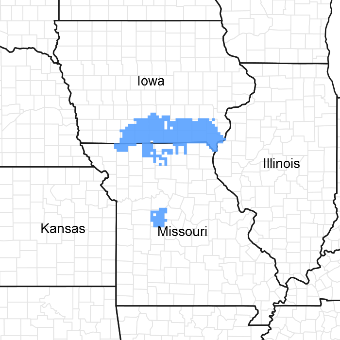
Figure 1. Mapped extent
Areas shown in blue indicate the maximum mapped extent of this ecological site. Other ecological sites likely occur within the highlighted areas. It is also possible for this ecological site to occur outside of highlighted areas if detailed soil survey has not been completed or recently updated.
MLRA notes
Major Land Resource Area (MLRA): 109X–Iowa and Missouri Heavy Till Plain
The Iowa and Missouri Heavy Till Plain is an area of rolling hills interspersed with interfluve divides and alluvial valleys. Elevation ranges from about 660 feet along the lower reaches of rivers, to about 980 feet on stable interfluve summits in southern Iowa. Relief is about 80 to 160 feet between major streams and adjacent interfluve summits. Most of the till plain drains south to the Missouri River via the Grand and Chariton River systems, but the northeastern portion drains southeast to the Mississippi River. Loess caps the pre-Illinoisan aged till on interfluves, whereas the till is exposed on side slopes. Mississippian aged limestone and Pennsylvanian aged sandstone and shale crop out on lower slopes in some areas.
Classification relationships
Terrestrial Natural Community Type in Missouri (Nelson, 2010):
The reference state for this ecological site is most similar to a Wet-Mesic Bottomland Prairie.
National Vegetation Classification System Vegetation Association (NatureServe, 2010):
The reference state for this ecological site is most similar to Andropogon gerardii - Panicum virgatum - Helianthus grosseserratus Herbaceous Vegetation (CEGL002024).
Geographic relationship to the Missouri Ecological Classification System (Nigh & Schroeder, 2002):
This ecological site occurs in several Land Type Associations, primarily within the following Subsections:
Grand River Hills
Loess Hills
Ecological site concept
NOTE: This is a “provisional” Ecological Site Description (ESD) that is under development. It contains basic ecological information that can be used for conservation planning, application and land management. As additional information is collected, analyzed and reviewed, this ESD will be refined and published as “Approved”.
Wet Loess High Terrace Savannas are primarily in the north and northeast parts of the MLRA, and on similar landscapes to the southwest. Soils are very deep, with loamy subsoils and seasonal high water tables. The reference plant community is savanna with scattered elm, bur oak, pin oak, shellbark hickory and willow, and a ground flora dominated by wet-tolerant grasses, sedges and forbs.
Associated sites
| R109XY002MO |
Loess Upland Prairie Loess Upland Prairies are upslope. |
|---|---|
| R109XY031MO |
Wet Floodplain Prairie Wet Floodplain Prairies are downslope. |
Similar sites
| R109XY038MO |
Wet Terrace Prairie Wet Terrace Prairies have similar ground flora composition but a lower overstory oak canopy density. |
|---|
Table 1. Dominant plant species
| Tree |
(1) Quercus palustris |
|---|---|
| Shrub |
(1) Salix humilis |
| Herbaceous |
(1) Spartina pectinata |
Physiographic features
This site is on high, Pleistocene-aged, loess-covered stream terraces and on footslopes, with slopes of 0 to 9 percent. The site generates some runoff to adjacent lower terrace and floodplain sites, and receives some runoff from adjacent uplands. This site does not flood.
The following figure (adapted from Boeckman, 1992) shows a typical landscape position of this ecological site, and landscape relationships among the major ecological sites of the floodplains and stream terraces. This site is within the area labeled as “1” on the figure, and is typically associated with Wet Terrace Prairie sites, and Floodplain ecological sites such as the Loamy Floodplain Forest and Wet Floodplain Prairie sites shown in the figure.
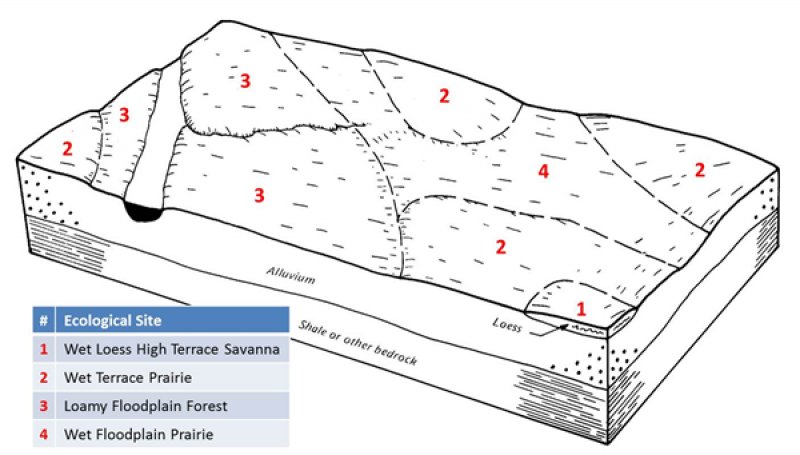
Figure 2. Landscape relationships for this ecological site
Table 2. Representative physiographic features
| Landforms |
(1)
Stream terrace
(2) Hill |
|---|---|
| Flooding frequency | None |
| Ponding frequency | None |
| Slope | 9% |
| Water table depth | 12 – 24 in |
| Aspect | Aspect is not a significant factor |
Climatic features
The Iowa and Missouri Heavy Till Plain MLRA has a continental type of climate marked by strong seasonality. In winter, dry-cold air masses, unchallenged by any topographic barriers, periodically swing south from the northern plains and Canada. If they invade reasonably humid air, snowfall and rainfall result. In summer, moist, warm air masses, equally unchallenged by topographic barriers, swing north from the Gulf of Mexico and can produce abundant amounts of rain, either by fronts or by convectional processes. In some summers, high pressure stagnates over the region, creating extended droughty periods. Spring and fall are transitional seasons when abrupt changes in temperature and precipitation may occur due to successive, fast-moving fronts separating contrasting air masses.
This MLRA experiences small regional differences in climates that grade inconspicuously into each other. The basic gradient for most climatic characteristics is along a line from north to south. Both mean annual temperature and precipitation exhibit fairly minor gradients along this line.
Mean January minimum temperature follows the north-to-south gradient. However, mean July maximum temperature shows hardly any geographic variation in the region. Mean July maximum temperatures have a range of only two to three degrees across the region.
Mean annual precipitation varies along the same gradient as temperature – lower annual precipitation in the north, higher in the south. Seasonality in precipitation is very pronounced due to strong continental influences. June precipitation, for example, averages four to five times greater than January precipitation.
During years when precipitation comes in a fairly normal manner, moisture is stored in the top layers of the soil during the winter and early spring, when evaporation and transpiration are low. During the summer months the loss of water by evaporation and transpiration is high, and if rainfall fails to occur at frequent intervals, drought will result. Drought directly influences ecological communities by limiting water supplies, especially at times of high temperatures and high evaporation rates. Drought indirectly affects ecological communities by increasing plant and animal susceptibility to the probability and severity of fire. Frequent fires encourage the development of grass/forb dominated communities and understories.
Superimposed upon the basic MLRA climatic patterns are local topographic influences that create topoclimatic, or microclimatic variations. For example, air drainage at nighttime may produce temperatures several degrees lower in valley bottoms than on side slopes. At critical times during the year, this phenomenon may produce later spring or earlier fall freezes in valley bottoms. Slope orientation is an important topographic influence on climate. Summits and south-and-west-facing slopes are regularly warmer and drier, supporting more grass dominated communities than adjacent north- and-east-facing slopes that are cooler and moister that support more woody dominated communities. Finally, the cooler microclimate within a canopied forest is measurably different from the climate of a more open and warmer grassland or savanna area.
Source: University of Missouri Climate Center - http://climate.missouri.edu/climate.php; Land Resource Regions and Major Land Resource Areas of the United States, the Caribbean, and the Pacific Basin, United States Department of Agriculture Handbook 296 - http://soils.usda.gov/survey/geography/mlra/
Table 3. Representative climatic features
| Frost-free period (characteristic range) | 134-158 days |
|---|---|
| Freeze-free period (characteristic range) | 165-188 days |
| Precipitation total (characteristic range) | 39 in |
| Frost-free period (actual range) | 129-169 days |
| Freeze-free period (actual range) | 161-196 days |
| Precipitation total (actual range) | 38-40 in |
| Frost-free period (average) | 146 days |
| Freeze-free period (average) | 176 days |
| Precipitation total (average) | 39 in |
Figure 3. Monthly precipitation range
Figure 4. Monthly minimum temperature range
Figure 5. Monthly maximum temperature range
Figure 6. Monthly average minimum and maximum temperature
Figure 7. Annual precipitation pattern
Figure 8. Annual average temperature pattern
Climate stations used
-
(1) KEOSAUQUA [USC00134389], Keosauqua, IA
-
(2) BLOOMFIELD 1 WNW [USC00130753], Bloomfield, IA
-
(3) DONNELLSON [USC00132299], Donnellson, IA
-
(4) KEOKUK LOCK DAM 19 [USC00134381], Keokuk, IA
-
(5) LEON 6 ESE [USC00134758], Garden Grove, IA
-
(6) SPICKARD 7 W [USC00237963], Spickard, MO
Influencing water features
This ecological site is influenced by a seasonal high-water table. In some soils on high, loess-covered stream terraces, the water table is perched on a clayey subsoil. Soils on footslopes are affected by lateral flow from upslope. This ecological site contains wetlands which fit into the MINERAL FLAT class in the Hydrogeomorphic (HGM) system (Brinson, 1993).
Vertical water percolation in the soil is impeded by the clayey subsoil, resulting in significant lateral discharge to adjacent downslope ecological sites. Sloping footslope positions, which receive water from upslope, may be in the SLOPE HGM class. Wetness and hydrology in most areas have been altered with the use of surface ditches, upslope diversion terraces, and other methods. Unaltered areas are Emergent Palustrine wetlands (Cowardin et al., 1979).
Soil features
These soils have no rooting restriction. The soils were formed under prairie vegetation, and have dark, organic-rich surface horizons. Parent material is loess, with alluvium or colluvium at depth. Footslope areas are formed entirely in colluvium. They have silt loam or loam surface horizons and clayey subsoils. They are affected by a seasonal high water table during the spring months. Soil series associated with this site include Bevier, Cantril, Ely, Edina, Grundy, Pering, and Pershing.
Table 4. Representative soil features
| Parent material |
(1)
Loess
(2) Alluvium (3) Colluvium |
|---|---|
| Surface texture |
(1) Silt loam (2) Loam |
| Family particle size |
(1) Clayey |
| Drainage class | Poorly drained to somewhat poorly drained |
| Permeability class | Slow |
| Surface fragment cover <=3" | Not specified |
| Surface fragment cover >3" | Not specified |
| Available water capacity (0-40in) |
6 in |
| Calcium carbonate equivalent (0-40in) |
Not specified |
| Electrical conductivity (0-40in) |
2 mmhos/cm |
| Sodium adsorption ratio (0-40in) |
Not specified |
| Soil reaction (1:1 water) (0-40in) |
5.2 – 6.5 |
| Subsurface fragment volume <=3" (Depth not specified) |
Not specified |
| Subsurface fragment volume >3" (Depth not specified) |
Not specified |
Ecological dynamics
Information contained in this section was developed using historical data, professional experience, field reviews, and scientific studies. The information presented is representative of very complex vegetation communities. Key indicator plants, animals and ecological processes are described to help inform land management decisions. Plant communities will differ across the MLRA because of the naturally occurring variability in weather, soils, and aspect. The Reference Plant Community is not necessarily the management goal. The species lists are representative and are not botanical descriptions of all species occurring, or potentially occurring, on this site. They are not intended to cover every situation or the full range of conditions, species, and responses for the site.
Wet Loess High Terrace Savannas occur at the base of slopes below Till Upland Prairies and above Wet Floodplain Prairies on relatively stable former floodplain positions that rarely flooded. This landscape position receives water from upslope, and poor drainage causes it to be periodically saturated. These conditions along with periodic fire, likely occurring at least once every 3 years, had a strong influence on excluding trees. Fire during dry periods removed the dense mat of leaf litter creating opportunities for plants less aggressive than the grasses and sedges.
Wet Loess High Terrace Savannas are dominated by a dense cover of wet tolerant grasses and forbs. On slightly higher areas within or at the edge of the soil component scattered elm, bur oak, pin oak, shellbark hickory and willow occurred throughout the landscape.
These sites were also subjected to grazing by native large herbivores, such as bison, elk, and white-tailed deer. Grazing by native herbivores would have effectively kept understory conditions open, creating conditions more favorable to ground flora species and minimizing woody trees and shrubs.
Today most of these ecological sites have been drained and farmed. Only a very few remnants exist. During wet years, they do act as ephemeral farmed wetlands in the agricultural landscape. Their position and soil properties still make them good candidates for wet prairie and savanna development management.
A State and Transition Diagram follows. Detailed descriptions of each state, transition, plant community, and pathway follow the model. This model is based on available experimental research, field observations, professional consensus, and interpretations. It is likely to change as knowledge increases.
State and transition model
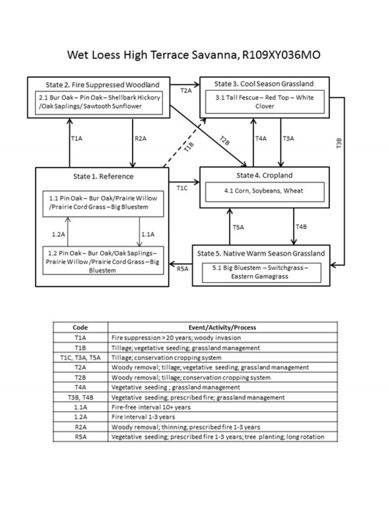
Figure 9. State and transition diagram for this ecologcial s
More interactive model formats are also available.
View Interactive Models
More interactive model formats are also available.
View Interactive Models
Click on state and transition labels to scroll to the respective text
Ecosystem states
States 1 and 5 (additional transitions)
State 2 submodel, plant communities
State 3 submodel, plant communities
State 4 submodel, plant communities
State 5 submodel, plant communities
State 1
Reference
This state is native oak savanna dominated by an understory of prairie cordgrass, big bluestem, eastern gamagrass and a wide variety of prairie forbs. This state occurs on level to gently sloping soils and are affected by a seasonal high water table during the spring months. Bur oak, pin oak, shellbark hickory, American elm, American hazelnut, prairie willow and wild plum occurred in small groves or as scattered individuals across the landscape. Two phases can occur that will transition back and forth depending on fire frequencies. Longer fire free intervals will allow woody species to increase such as oak saplings, prairie willow, dogwoods and wild plum. When fire intervals shorten these woody species will decrease. This state is very rare. Nearly all former reference states have been converted to cool season grassland and intensive agriculture cropland or reverted to a woodland community.
Dominant plant species
-
bur oak (Quercus macrocarpa), tree
-
pin oak (Quercus palustris), tree
-
prairie willow (Salix humilis), shrub
-
oak (Quercus), shrub
-
prairie cordgrass (Spartina pectinata), other herbaceous
-
big bluestem (Andropogon gerardii), other herbaceous
Community 1.1
Pin Oak – Bur Oak/Prairie Willow /Prairie Cord Grass – Big Bluestem
This phase is a savanna dominated by big bluestem, prairie cord grass and a wide variety of prairie wildflowers and sedges. Bur oak, swamp white oak, pin oak, elm, false indigo, prairie willow and wild plum occur in small groves or as scattered individuals across the open landscape.
Forest overstory. The Forest Overstory Species list is based on commonly occurring species listed in Nelson (2010).
Forest understory. The Forest Understory list is based on commonly occurring species listed in Nelson (2010).
Dominant plant species
-
pin oak (Quercus palustris), tree
-
bur oak (Quercus macrocarpa), tree
-
prairie willow (Salix humilis), shrub
-
prairie cordgrass (Spartina pectinata), grass
-
big bluestem (Andropogon gerardii), grass
Community 1.2
Pin Oak – Bur Oak/Oak Saplings – Prairie Willow /Prairie Cord Grass – Big Bluestem
This phase is similar to community phase 1.1 but oaks and shrubs are increasing due to longer periods of fire suppression. Some displacement of grasses and forbs may be occurring due to shading and competition from the increased canopy cover.
Dominant plant species
-
pin oak (Quercus palustris), tree
-
bur oak (Quercus macrocarpa), tree
-
oak (Quercus), shrub
-
prairie willow (Salix humilis), shrub
-
prairie cordgrass (Spartina pectinata), other herbaceous
-
big bluestem (Andropogon gerardii), other herbaceous
Pathway 1.1A
Community 1.1 to 1.2
Fire-free interval 10+ years
Pathway 1.2A
Community 1.2 to 1.1
Fire interval 1-3 years
State 2
Fire Suppressed Woodland
Degraded reference states that have experienced fire suppression and woody invasion for 20 or more years will transition to this state. With fire suppression, woody species such as bur oak, pin oak, and shellbark hickory will begin to increase transitioning this state from a savanna to an open woodland. Native herbaceous ground cover will also decrease.
Dominant plant species
-
bur oak (Quercus macrocarpa), tree
-
pin oak (Quercus palustris), tree
-
shellbark hickory (Carya laciniosa), tree
-
oak (Quercus), shrub
-
sawtooth sunflower (Helianthus grosseserratus), other herbaceous
Community 2.1
Bur Oak – Pin Oak – Shellbark Hickory /Oak Saplings/ Sawtooth Sunflower
Dominant plant species
-
bur oak (Quercus macrocarpa), tree
-
pin oak (Quercus palustris), tree
-
shellbark hickory (Carya laciniosa), tree
-
oak (Quercus), shrub
-
sawtooth sunflower (Helianthus grosseserratus), other herbaceous
State 3
Cool Season Grassland
Conversion of other states to non-native cool season species such as tall fescue, red top and white clover has been common in this area. Occasionally, these pastures may have scattered bur oaks. Long term uncontrolled grazing and/or a lack of grassland management can cause significant soil erosion and compaction and increases in less productive species such as Kentucky bluegrass and weedy forbs such as ironweed. A return to the reference state may be impossible, requiring a very long term series of management options.
Dominant plant species
-
tall fescue (Schedonorus arundinaceus), other herbaceous
-
redtop (Agrostis gigantea), other herbaceous
-
white clover (Trifolium repens), other herbaceous
Community 3.1
Tall Fescue – Red Top – White Clover
Dominant plant species
-
tall fescue (Schedonorus arundinaceus), other herbaceous
-
redtop (Agrostis gigantea), other herbaceous
-
white clover (Trifolium repens), other herbaceous
State 4
Cropland
This is the dominant state that exists currently with intensive cropping of corn, wheat and soybeans occurring. Some conversion to cool season hayland may occur for a limited period of time before transitioning back to cropland. Limited acres are sometimes converted to native warm season grassland through federal set-aside programs.
Community 4.1
Corn, Soybeans, Wheat
Dominant plant species
State 5
Native Warm Season Grassland
Conversion from the Cool Season Grassland (State 3) or the Cropland (State 4) to this state is increasing due to renewed interest in warm season grasses as a supplement to cool season grazing systems or as a native restoration activity. This state can be transformed back to a reference state. Substantial restoration time, management inputs and costs will still be needed.
Dominant plant species
-
big bluestem (Andropogon gerardii), other herbaceous
-
switchgrass (Panicum virgatum), other herbaceous
-
eastern gamagrass (Tripsacum dactyloides), other herbaceous
Community 5.1
Big Bluestem – Switchgrass – Eastern Gamagrass
Dominant plant species
-
big bluestem (Andropogon gerardii), other herbaceous
-
switchgrass (Panicum virgatum), other herbaceous
-
gamagrass (Tripsacum), other herbaceous
Transition T1A
State 1 to 2
Fire suppression >20 years; woody invasion
Transition T1B
State 1 to 3
Transition T1C
State 1 to 4
Tillage; conservation cropping system
Restoration pathway R2A
State 2 to 1
Woody removal; thinning; prescribed fire 1-3 years
Transition T2A
State 2 to 3
Woody removal; tillage; vegetative seeding; grassland management
Transition T2B
State 2 to 4
Woody removal; tillage; conservation cropping system
Transition T3A
State 3 to 4
Tillage; conservation cropping system
Transition T3B
State 3 to 5
Vegetative seeding; prescribed fire; grassland management
Restoration pathway T4A
State 4 to 3
Vegetative seeding; grassland management
Transition T4B
State 4 to 5
Vegetative seeding; prescribed fire; grassland management
Restoration pathway R5A
State 5 to 1
Vegetative seeding; prescribed fire 1-3 years; tree planting; long rotation
Restoration pathway T5A
State 5 to 4
Tillage; conservation cropping system
Additional community tables
Table 5. Community 1.1 forest overstory composition
| Common name | Symbol | Scientific name | Nativity | Height (ft) | Canopy cover (%) | Diameter (in) | Basal area (square ft/acre) |
|---|---|---|---|---|---|---|---|
|
Tree
|
|||||||
| slippery elm | ULRU | Ulmus rubra | Native | – | 5–10 | – | – |
| shellbark hickory | CALA21 | Carya laciniosa | Native | – | 5–10 | – | – |
| bur oak | QUMA2 | Quercus macrocarpa | Native | – | 5–10 | – | – |
| pin oak | QUPA2 | Quercus palustris | Native | – | 5–10 | – | – |
Table 6. Community 1.1 forest understory composition
| Common name | Symbol | Scientific name | Nativity | Height (ft) | Canopy cover (%) | |
|---|---|---|---|---|---|---|
|
Grass/grass-like (Graminoids)
|
||||||
| prairie cordgrass | SPPE | Spartina pectinata | Native | – | 20–40 | |
| big bluestem | ANGE | Andropogon gerardii | Native | – | 20–30 | |
| switchgrass | PAVI2 | Panicum virgatum | Native | – | 10–20 | |
| bluejoint | CACA4 | Calamagrostis canadensis | Native | – | 10–20 | |
| hop sedge | CALU4 | Carex lupulina | Native | – | 10–20 | |
| fox sedge | CAVU2 | Carex vulpinoidea | Native | – | 10–20 | |
| fescue sedge | CAFE3 | Carex festucacea | Native | – | 10–20 | |
| Canada wildrye | ELCA4 | Elymus canadensis | Native | – | 10–20 | |
|
Forb/Herb
|
||||||
| sawtooth sunflower | HEGR4 | Helianthus grosseserratus | Native | – | 5–20 | |
| swamp milkweed | ASIN | Asclepias incarnata | Native | – | 5–20 | |
| smooth white oldfield aster | SYRA5 | Symphyotrichum racemosum | Native | – | 5–20 | |
| winged lythrum | LYAL4 | Lythrum alatum | Native | – | 5–20 | |
| white doll's daisy | BOAS | Boltonia asteroides | Native | – | 5–20 | |
| sweet coneflower | RUSU | Rudbeckia subtomentosa | Native | – | 5–20 | |
| bearded beggarticks | BIAR | Bidens aristosa | Native | – | 5–20 | |
| prairie ironweed | VEFA2 | Vernonia fasciculata | Native | – | 5–20 | |
| Virginia bunchflower | VEVI5 | Veratrum virginicum | Native | – | 5–20 | |
| Culver's root | VEVI4 | Veronicastrum virginicum | Native | – | 5–20 | |
|
Shrub/Subshrub
|
||||||
| false indigo bush | AMFR | Amorpha fruticosa | Native | – | 5–20 | |
| prairie willow | SAHU2 | Salix humilis | Native | – | 5–20 | |
Interpretations
Animal community
Wildlife
Prairie Phase
Game species that utilize this ecological site include:
White-tailed Deer will utilize this ecological site for browse (plant leaves in the growing season, seeds and soft mast in the fall/winter). This site type also can provide escape cover.
Migratory Waterbirds: Sora, Common Snipe and Virginia Rail
Furbearers: Muskrat, Beaver, and Mink.
Bird species associated with this ecological site’s reference state condition:
Breeding birds: Sedge Wren, Red-Winged Blackbird, American Bittern, Marsh Wren, and Common Yellowthroat.
Migratory birds: Sora, Virginia Rail, Sedge Wren, American Bittern, Yellow Rail and Common Snipe.
Amphibian and reptile species associated with this ecological site’s reference state condition: Western Chorus Frog (Pseudacris triseriata triseriata), Plains Leopard Frog (Rana blairi), Graham’s Crayfish Snake (Regina grahamii), Midland Brown Snake (Storeria dekayi wrightourm), prairies with crawfish burrows may have Northern Crawfish Frog (Rana areolata circulosa); Western Fox Snake (Elaphe vulpina vulpina), and Western Massasauga rattlesnake (Sistrurus catenatus tergeminus).
Small mammals associated with this ecological site’s reference state condition: Muskrat (Ondatra zibethicus), Southern Bog Lemming (Synaptomys cooperi), and Mink (Mustela vison).
Many native insect species are likely associated with this ecological site, especially native bees, ants, beetles, butterflies and moths, and crickets, grasshoppers and katydids. However information on these groups is often lacking enough resolution to assign them to individual ecological sites.
Insect species known to be associated with this ecological site’s reference state condition: Swamp Milkweed Leaf Beetle (Labidomera clivicollis), Cordgrass Planthopper (Prokelisia crocea), Dion Skipper butterfly (Euphyes dion), Duke’s Skipper butterfly (Euphyes dukesi), native bees (Lasioglossum hartii, Hesperapis carinata, Svastra atripes and Cemolobus ipomoeae), Bullate Meadow katydid (Orchelimum bullatum) and Sedge Grasshopper (Stethophyma celatum).
Other invertebrates: Grassland Crayfish (Procambarus gracilis)
Savanna Phase:
Both snags and live cavity or den trees provide important food and cover for vertebrate wildlife. Snags are also very important to invertebrate species. Wood Duck and Red-headed Woodpecker utilize snags and den trees for foraging, nesting or shelter. “Wolf” trees are a particularly valuable type of live cavity tree. These large diameter, often open-grown, old-ages, hollow trees provide both cavities for wildlife and usually hard or soft mast food sources. Large diameter snags and den trees are particularly important wildlife habitat features to retain.
Extremely little is known about this phase of this ecological site. It is assumed that many of the animal species described under the prairie phase of this ecological site are found in the savanna phase. Additional species that might be expected in the savanna phase: Red-headed Woodpecker, Wood Duck, Yellow Warbler, Fox Squirrel, and Indiana Bat.
(This section prepared by Mike Leahy, Natural Areas Coordinator, Missouri Department of Conservation, 2013. References for this section: Fitzgerald and Pashley 2000b; Heitzman and Heitzman 1996; Jacobs 2001; Johnson 2000; Pitts and McGuire 2000; Schwartz and others 2001)
Other information
Forestry
Management: This ecological site is not recommended for traditional timber management activity. Historically this site was dominated by a ground cover of native prairie grasses and forbs with scattered open grown trees. Altered states mayy be suitable for non-traditional forestry uses such as windbreaks, environmental plantings, alley cropping (a method of planting, in which rows of trees or shrubs are interspersed with rows of crops) or woody bio-fuels.
Supporting information
Inventory data references
Potential Reference Sites: Wet Loess High Terrace Savanna
Plot DRPRCA03 – Pershing soil
Located in Drovers Prairie CA, Benton County, MO
Latitude: 38.531451
Longitude: -93.297003
Plot FRPRCA03 – Pershing soil
Located in Friendly Prairie CA, Pettis County, MO
Latitude: 38.553256
Longitude: -93.295528
Other references
Anderson, R.C. 1990. The historic role of fire in North American grasslands. Pp. 8-18 in S.L. Collins and L.L. Wallace (eds.). Fire in North American tallgrass prairies. University of Oklahoma Press, Norman.
Boeckman, Louis E. 1992. Soil Survey of Ringgold County, Iowa. U.S. Dept. of Agric. Soil Conservation Service.
Brinson, M.M. 1993. A hydrogeomorphic classification for wetlands. Technical Report WRP-DE-4, U.S. Army Corps of Engineers, Engineer Waterways Experiment Station, Vicksburg, MS.
Cowardin, L.M., V. Carter, F.C. Golet, & E.T. LaRoe. 1979. Classification of wetlands and deepwater habitats of the United States. U.S. Dept. of Interior, Fish & Wildlife Service, Office of Biological Services, Washington DC.
Fitzgerald, J.A. and D.N. Pashley. 2000b. Partners in Flight bird conservation plan for the Dissected Till Plains. American Bird Conservancy.
Frost, C., 1996. Pre-settlement Fire Frequency Regimes of the United States: A First Approximation. Pages 70-81, Proceedings of the 20nd Tall Timbers Fire Ecology Conference: Fire in Ecosystem Management: Shifting the Paradigm from Suppression to Prescription. Tall Timbers Research Station, Tallahassee, FL.
Heitzman, J.R. and J.E. Heitzman. 1996. Butterflies and moths of Missouri. 2nd ed. Missouri Department of Conservation, Jefferson City.
Jacobs, B. 2001. Birds in Missouri. Missouri Department of Conservation, Jefferson City.
Johnson, T.R. 2000. The amphibians and reptiles of Missouri. 2nd ed. Missouri Department of Conservation, Jefferson City.
Natural Resources Conservation Service. 2002. Woodland Suitability Groups. Missouri FOTG, Section II, Soil Interpretations and Reports. 30 pgs.
Natural Resources Conservation Service. Site Index Reports. Accessed May 2014. https://esi.sc.egov.usda.gov/ESI_Forestland/pgFSWelcome.aspx
NatureServe. 2010. Vegetation Associations of Missouri (revised). NatureServe, St. Paul, Minnesota.
Nelson, Paul W. 2010. The Terrestrial Natural Communities of Missouri. Missouri Department of Conservation, Jefferson City, Missouri.
Nigh, Timothy A. and Walter A. Schroeder. 2002. Atlas of Missouri Ecoregions. Missouri Department of Conservation, Jefferson City, Missouri.
Pitts, D.E. and W.D. McGuire. 2000. Wildlife management for Missouri landowners. 3rd ed. Missouri Department of Conservation, Jefferson City.
Schwartz, C.W., E.R. Schwartz and J.J. Conley. 2001. The wild mammals of Missouri. University of Missouri Press, Columbia and Missouri Department of Conservation, Jefferson City.
United States Department of Agriculture – Natural Resource Conservation Service (USDA-NRCS). 2006. Land Resource Regions and Major Land Resource Areas of the United States, the Caribbean, and the Pacific Basin. U.S. Department of Agriculture Handbook 296. 682 pgs.
Contributors
Doug Wallace
Fred Young
Approval
Suzanne Mayne-Kinney, 7/01/2024
Acknowledgments
Missouri Department of Conservation and Missouri Department of Natural Resources personnel provided significant and helpful field and technical support in the development of this ecological site.
This site was originally approved on 07/28/2015 for publication.
Rangeland health reference sheet
Interpreting Indicators of Rangeland Health is a qualitative assessment protocol used to determine ecosystem condition based on benchmark characteristics described in the Reference Sheet. A suite of 17 (or more) indicators are typically considered in an assessment. The ecological site(s) representative of an assessment location must be known prior to applying the protocol and must be verified based on soils and climate. Current plant community cannot be used to identify the ecological site.
| Author(s)/participant(s) | |
|---|---|
| Contact for lead author | |
| Date | 07/02/2024 |
| Approved by | Suzanne Mayne-Kinney |
| Approval date | |
| Composition (Indicators 10 and 12) based on | Annual Production |
Indicators
-
Number and extent of rills:
-
Presence of water flow patterns:
-
Number and height of erosional pedestals or terracettes:
-
Bare ground from Ecological Site Description or other studies (rock, litter, lichen, moss, plant canopy are not bare ground):
-
Number of gullies and erosion associated with gullies:
-
Extent of wind scoured, blowouts and/or depositional areas:
-
Amount of litter movement (describe size and distance expected to travel):
-
Soil surface (top few mm) resistance to erosion (stability values are averages - most sites will show a range of values):
-
Soil surface structure and SOM content (include type of structure and A-horizon color and thickness):
-
Effect of community phase composition (relative proportion of different functional groups) and spatial distribution on infiltration and runoff:
-
Presence and thickness of compaction layer (usually none; describe soil profile features which may be mistaken for compaction on this site):
-
Functional/Structural Groups (list in order of descending dominance by above-ground annual-production or live foliar cover using symbols: >>, >, = to indicate much greater than, greater than, and equal to):
Dominant:
Sub-dominant:
Other:
Additional:
-
Amount of plant mortality and decadence (include which functional groups are expected to show mortality or decadence):
-
Average percent litter cover (%) and depth ( in):
-
Expected annual annual-production (this is TOTAL above-ground annual-production, not just forage annual-production):
-
Potential invasive (including noxious) species (native and non-native). List species which BOTH characterize degraded states and have the potential to become a dominant or co-dominant species on the ecological site if their future establishment and growth is not actively controlled by management interventions. Species that become dominant for only one to several years (e.g., short-term response to drought or wildfire) are not invasive plants. Note that unlike other indicators, we are describing what is NOT expected in the reference state for the ecological site:
-
Perennial plant reproductive capability:
Print Options
Sections
Font
Other
The Ecosystem Dynamics Interpretive Tool is an information system framework developed by the USDA-ARS Jornada Experimental Range, USDA Natural Resources Conservation Service, and New Mexico State University.
Click on box and path labels to scroll to the respective text.