Natural Resources
Conservation Service
Ecological site F113XY003MO
Claypan Summit Woodland
Accessed: 04/25/2024
General information
Provisional. A provisional ecological site description has undergone quality control and quality assurance review. It contains a working state and transition model and enough information to identify the ecological site.
Figure 1. Mapped extent
Areas shown in blue indicate the maximum mapped extent of this ecological site. Other ecological sites likely occur within the highlighted areas. It is also possible for this ecological site to occur outside of highlighted areas if detailed soil survey has not been completed or recently updated.
MLRA notes
Major Land Resource Area (MLRA): 113X–Central Claypan Areas
The western, Missouri portion of the Central Claypan (area outlined in red on the map) is a weakly dissected till plain. Elevation ranges from about 1,000 feet in the north along the divide between the Missouri and Mississippi River watersheds to about 625 feet where the North Fork of the Salt River flows out of the area. Relief is generally low, with low slope gradients and relatively narrow drainageways. Most of the Central Claypan is in the Salt River watershed. The characteristic “claypan” occurs in the loess that caps the pre-Illinoisan aged till on the broad interfluves that characterize this region. Till is exposed on lower slopes. The underlying Mississippian aged limestone and Pennsylvanian aged shale is exposed in only a few places along lower slopes above the Salt River.
Classification relationships
Terrestrial Natural Community Type in Missouri (Nelson, 2010):
The reference state for this ecological site is most similar to an Upland Flatwoods.
Missouri Department of Conservation Forest and Woodland Communities (Missouri Department of Conservation, 2006):
The reference state for this ecological site is most similar to a Mixed Oak Loess/Glacial Till Woodland.
National Vegetation Classification System Vegetation Association (NatureServe, 2010):
The reference state for this ecological site is most similar to a Quercus stellata - Quercus velutina / Schizachyrium scoparium Woodland (CEGL005281).
Geographic relationship to the Missouri Ecological Classification System (Nigh & Schroeder, 2002):
This ecological site occurs throughout the Claypan Till Plains Subsection, and in adjacent Land Type Associations of the Outer Ozark Border and Chariton River Hills Subsections.
Ecological site concept
NOTE: This is a “provisional” Ecological Site Description (ESD) that is under development. It contains basic ecological information that can be used for conservation planning, application and land management. After additional information is collected, analyzed and reviewed, this ESD will be refined and published as “Approved”.
Claypan Summit Woodlands (green area on the map) are scattered mainly on the fringes of the MLRA, in transitional areas between the broad prairie summit ecological sites and the woodland hillslope ecological sites. Soils have a silty clay subsoil that perches water in the spring, and affects rooting depth. The reference plant community is woodland with an overstory dominated by post oak and black oak, and a ground flora of native grasses and forbs.
Associated sites
F109XY007MO |
Till Upland Woodland Till Upland Woodlands are downslope, on shoulders and upper backslopes. |
---|---|
R113XY001MO |
Claypan Summit Prairie Claypan Summit Prairies are adjacent, on broad prairie landscapes. |
Similar sites
F113XY003MO |
Claypan Summit Woodland Claypan Summit Woodlands have no similar sites in this MLRA. |
---|
Table 1. Dominant plant species
Tree |
(1) Quercus stellata |
---|---|
Shrub |
(1) Prunus americana |
Herbaceous |
(1) Panicum virgatum |
Physiographic features
This site is on upland summit interfluves and ridge crests, with slopes of 2 to 5 percent. The site generates runoff to adjacent, downslope ecological sites. This site does not flood.
The following figure (adapted from Young and Geller, 1995) shows the typical landscape position of this ecological site, and landscape relationships among the three dominant upland woodland ecological sites in this MLRA.
Figure 2. Landscape sequence of ecological sites
Table 2. Representative physiographic features
Landforms |
(1)
Interfluve
(2) Divide |
---|---|
Flooding frequency | None |
Ponding frequency | None |
Slope | 2 – 5% |
Water table depth | 8 – 10 in |
Aspect | Aspect is not a significant factor |
Climatic features
The western part of the Central Claypan Area MLRA has a continental type of climate marked by strong seasonality. In winter, dry-cold air masses, unchallenged by any topographic barriers, periodically swing south from the northern plains and Canada. If they invade reasonably humid air, snowfall and rainfall result. In summer, moist, warm air masses, equally unchallenged by topographic barriers, swing north from the Gulf of Mexico and can produce abundant amounts of rain, either by fronts or by convectional processes. In some summers, high pressure stagnates over the region, creating extended droughty periods. Spring and fall are transitional seasons when abrupt changes in temperature and precipitation may occur due to successive, fast-moving fronts separating contrasting air masses.
This western part of the MLRA experiences regional differences in climates that grade across the region. The basic gradient for most mean annual climatic characteristics is along a line from north to south. Both mean annual temperature and precipitation exhibit modest gradients along this line.
Mean January minimum temperature follows a north to south gradient. However, mean July maximum temperature shows hardly any geographic variation in the region. Mean July maximum temperatures have a range of only two to three degrees across the region.
Mean annual precipitation also varies along the north to south gradient – lower annual precipitation in the north, somewhat higher in the south. Seasonality in precipitation is very pronounced due to strong continental influences. June precipitation, for example, averages three to four times greater than January precipitation.
During years when precipitation comes in a fairly normal manner, moisture is stored in the top layers of the soil during the winter and early spring, when evaporation and transpiration are low. During the summer months the loss of water by evaporation and transpiration is high, and if rainfall fails to occur at frequent intervals, drought will result. Drought directly influences ecological communities by limiting water supplies, especially at times of high temperatures and high evaporation rates. Drought indirectly affects ecological communities by increasing plant and animal susceptibility to the probability and severity of fire. Frequent fires encourage the development of grass/forb dominated communities and understories.
Superimposed upon the basic MLRA climatic patterns are local topographic influences that create topoclimatic, or microclimatic variations. For example, air drainage at nighttime may produce temperatures several degrees lower in valley bottoms than on side slopes. At critical times during the year, this phenomenon may produce later spring or earlier fall freezes in valley bottoms. Slope orientation is an important topographic influence on microclimate. Summits and south-and-west-facing slopes are regularly warmer and drier, supporting more grass dominated communities than adjacent north- and-east-facing slopes that are cooler and moister that support more woody dominated communities especially the moister valleys in the region. Finally, the cooler microclimate within a canopied forest is measurably different from the climate of a more open and warmer grassland or savanna area.
Source: University of Missouri Climate Center - http://climate.missouri.edu/climate.php; Land Resource Regions and Major Land Resource Areas of the United States, the Caribbean, and the Pacific Basin, United States Department of Agriculture Handbook 296 - http://soils.usda.gov/survey/geography/mlra/
Table 3. Representative climatic features
Frost-free period (average) | 178 days |
---|---|
Freeze-free period (average) | 194 days |
Precipitation total (average) | 45 in |
Figure 3. Monthly precipitation range
Figure 4. Monthly average minimum and maximum temperature
Figure 5. Annual precipitation pattern
Figure 6. Annual average temperature pattern
Climate stations used
-
(1) COLUMBIA RGNL AP [USW00003945], Columbia, MO
-
(2) SHELBINA [USC00237720], Shelbina, MO
-
(3) VANDALIA [USC00238577], Vandalia, MO
-
(4) MOBERLY [USC00235671], Moberly, MO
Influencing water features
This ecological site is influenced by a seasonal high water table, perched on the clayey subsoil. Some depressional areas pond for short periods of time, mostly in the spring. These shallow depressional areas were more common prior to the conversion of nearly all areas of this ecological site from woodland to cropland. Leveling and surface drainage have reduced or eliminated the shallow depressions. These areas were Forested Palustrine wetlands (Cowardin et al., 1979).
This ecological site contains wetlands which fit into the MINERAL FLAT class in the Hydrogeomorphic (HGM) system (Brinson, 1993). The water source is direct precipitation, because there are no upslope contributing sites. Dominant hydrodynamics are vertical fluctuations. Mineral soil flats lose water by evapotranspiration, overland flow, and seepage to underlying groundwater. Vertical water percolation in the soil is impeded by the clayey subsoil (the “claypan”), resulting in significant lateral discharge to adjacent downslope ecological sites. Adjacent sites include Headwater SLOPE HGM class sites in watershed headwaters. This discharge supports surface saturation in the adjacent areas.
In general, MINERAL FLAT areas provide watershed recharge and runoff that accumulates in downslope reaches as groundwater discharge and surface water accumulation. Wetland hydrology is effectively removed by surface ditches or subsurface tile drainage that directs vertical downward movement in a horizontal direction to the drainage element.
Wetland hydrology is also influenced by the surface storage afforded by vegetation and natural surface roughness. This storage is a large part of the water budget, allowing the profile to be re-filled with water which would otherwise run off. In extreme cases, conversion to agriculture can completely remove wetland hydrology.
Soil features
These soils have silty clay subsoils at about 8 to 13 inches, which impede but do not exclude rooting. The soils were formed under woodland vegetation, and have thin, light-colored surface horizons. They have silt loam surface horizons, and silty clay to clay subsoils. Parent material is loess underlain by pedisediment derived from loess and till. A seasonal high water table is perched above the clayey subsoil during the spring months in most years. Soil series associated with this site include Calwoods and Marion.
Table 4. Representative soil features
Surface texture |
(1) Silt loam (2) Silty clay loam |
---|---|
Family particle size |
(1) Clayey |
Drainage class | Somewhat poorly drained |
Permeability class | Very slow |
Soil depth | 72 in |
Surface fragment cover <=3" | Not specified |
Surface fragment cover >3" | Not specified |
Available water capacity (0-40in) |
6 in |
Calcium carbonate equivalent (0-40in) |
Not specified |
Electrical conductivity (0-40in) |
2 mmhos/cm |
Sodium adsorption ratio (0-40in) |
Not specified |
Soil reaction (1:1 water) (0-40in) |
5.1 – 7.3 |
Subsurface fragment volume <=3" (Depth not specified) |
2% |
Subsurface fragment volume >3" (Depth not specified) |
Not specified |
Ecological dynamics
Information contained in this section was developed using historical data, professional experience, field reviews, and scientific studies. The information presented is representative of very complex vegetation communities. Key indicator plants, animals and ecological processes are described to help inform land management decisions. Plant communities will differ across the MLRA because of the naturally occurring variability in weather, soils, and aspect. The Reference Plant Community is not necessarily the management goal. The species lists are representative and are not botanical descriptions of all species occurring, or potentially occurring, on this site. They are not intended to cover every situation or the full range of conditions, species, and responses for the site.
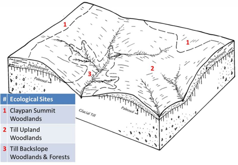
The reference plant community is an open woodland dominated by an overstory of post oak and black oak, with and occasional pin oak, elm and hickory. The canopy is moderately tall (55 to 70 feet) but less dense (30 to 60 percent closure) and less structurally diverse than adjacent Loess Upland Woodlands or Till Backslope Woodlands and Forests. Increased light from an open canopy causes a diversity of woodland ground flora species to flourish, especially prairie grasses. The claypan soil subsoil perches water in the spring and affects rooting depth of this ecological site limiting the growth of trees and supporting an abundance of native grasses and forbs in the understory. Seasonal wetness allows an abundance of sedges and wild ryes to occur in the understory. Woodlands are distinguished from forest, by their relatively open understory, and the presence of sun-loving ground flora species. Characteristic plants in the ground flora can be used to gauge the restoration potential of a stand along with remnant open-grown old-age trees, and tree height growth.
Because of their proximity to prairies, fire played a significant role in the maintenance of these systems. It is likely that these ecological sites burned at least once every 3 to 5 years. These periodic fires kept woodlands open, removed the litter, and stimulated the growth and flowering of the grasses and forbs. During fire free intervals, woody understory species increased and the herbaceous understory diminished. The return of fire would open the woodlands up again and stimulate the abundant ground flora.
Claypan Summit Woodlands were also subjected to occasional disturbances from wind and ice, as well as grazing by native large herbivores. Wind and ice would have periodically opened the canopy up by knocking over trees or breaking substantial branches off canopy trees. Grazing by large native herbivores would have effectively kept understory conditions more open, creating conditions more favorable to oak reproduction and woodland ground flora species.
Today, most of these ecological sites have been cleared and converted to pasture and cropland. Remaining woodland ecological sites have a younger (50 to 80 years) canopy layer whose species composition and quality has been altered by timber harvesting practices. In the long term absence of fire, woody species, especially hickory and sugar maple, encroach into these woodlands. Once established, these woody plants can quickly fill the existing understory increasing shade levels with a greatly diminished ground flora. Removal of the younger understory and the application of prescribed fire have proven to be effective restoration means.
Uncontrolled domestic grazing has also impacted these communities, further diminishing the diversity of native plants and introducing species that are tolerant of grazing, such as buckbrush, gooseberry, and Virginia creeper. Grazed sites also have a more open understory. In addition, soil compaction and soil erosion can be a problem and lower productivity.
These ecological sites are not very productive. Oak regeneration is typically problematic. Eastern hop hornbeam and hickories are often dominant competitors in the understory. Maintenance of the oak component will require disturbances that will encourage more sun adapted species and reduce shading effects. Some thinning of the dense stands and periodic fire will be needed to maintain the ground flora diversity and open stand structure.
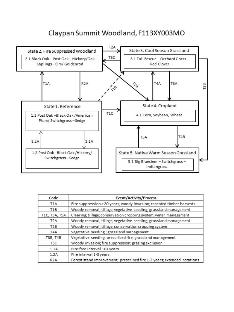
A State and Transition Diagram follows. Detailed descriptions of each state, transition, plant community, and pathway follow the model. This model is based on available experimental research, field observations, professional consensus, and interpretations. It may change as knowledge increases.
State and transition model
Figure 7. State and Transition Model for this ecological sit
More interactive model formats are also available.
View Interactive Models
More interactive model formats are also available.
View Interactive Models
Click on state and transition labels to scroll to the respective text
State 1 submodel, plant communities
State 2 submodel, plant communities
State 3 submodel, plant communities
State 4 submodel, plant communities
State 5 submodel, plant communities
State 1
Reference
These open woodland communities were strongly influenced by fire and seasonal soil wetness. Herbivory by native (now expatriated) ungulates also played a role. Consequently, fire-tolerant post and black oaks over a ground flora of tallgrass prairie grasses, sedges and wildflowers made up the claypan woodland. There are two phases associated with this Reference State.
Community 1.1
Post Oak-Black Oak/Wild Plum/Switchgrass - Sedge
The overstory in this phase is dominated by post oak and black oak, with scattered hickories. This open woodland community typically has a two-tiered structure, with canopy height of 35 to 50 feet and 30 to 60 percent closure. The abundant herbaceous layer is dominated by switchgrass, little bluestem, big bluestem and Indian grass. Fire frequency was every 1 to 3 years. This continued fire and natural native grazing would have maintained the more open canopy and profusion of ground flora species.
Forest overstory. The Forest Overstory Species list is based on commonly occurring species listed in Nelson (2010).
Forest understory. The Forest Understory Species list is based on commonly occurring species listed in Nelson (2010).
Community 1.2
Post Oak - Black Oak/Hickory/Switchgrass - Sedge
The overstory in this phase is dominated by post oak and black oak, with scattered hickories. This brushy woodland community typically has a three-tiered structure, with 50 to 80 percent closure. It is characterized by a thick understory of oak saplings, and shrubs. The herbaceous layer is dominated by prairie grasses and sedges. Fire-free intervals ranged from 5 to 10 years.
State 2
Fire Suppressed Woodland
Most current areas of Claypan Woodlands have experienced fire exclusion for decades. In the absence of fire, ongoing recruitment of trees into the canopy develops a closed canopy, shading out the herbaceous ground flora. This results in the formation of Post Oak – Black Oak – Black Hickory / Oak – Hickory Saplings / Goldenrod woodland. Black oak and midstory species increase. Herbaceous cover and diversity greatly diminishes, leaf litter builds up, and more shade-tolerant woodland species persist, such as elm-leaved goldenrod, panic grass and spreading aster. The understory also develops with oak and hickory saplings along with sassafras and black cherry. Transition to cool season grasslands (State 3) or intensive cropland (State 4) is very common.
Community 2.1
Black Oak - Post Oak - Hickory/Oak Saplings - Elm/Goldenrod
Oak and hickory species are increasing due to fire suppression. Displacement of grasses and forbs is occurring due to shading and competition from the increased densities of oak and hickory saplings. Canopy cover ranges from 70 to 90 percent. Most stands are 50 to 80 years of age.
State 3
Cool Season Grassland
Conversion of other states to non-native cool season species such as tall fescue and red clover has been common in the Missouri Central Claypan area. Occasionally, these pastures will have scattered post and pin oaks. Long term uncontrolled grazing can cause significant soil erosion and compaction. A return to the Reference State may be impossible, requiring a very long term series of management options.
Community 3.1
Tall Fescue - Orchard Grass - Red Clover
This phase is well managed grassland, composed of non-native cool season grasses and legumes. Grazing and haying is occurring. The effects of long-term liming on soil pH, and calcium and magnesium content, is most evident in this phase. Studies show that these soils have higher pH and higher base status in soil horizons as much as two feet below the surface, relative to a poorly managed grassland and to woodland communities (where liming is not practiced).
State 4
Cropland
This is the dominant State that exists currently with intensive cropping of corn, soybeans, and wheat occurring. Some conversion to cool season grassland occurs for a limited period of time before transitioning back to cropland. Limited acres are sometimes converted to native warm season grassland.
Community 4.1
Corn, Soybean, Wheat
This phase has intensive cropping of corn, soybeans, and wheat. Tillage operations generally leave little residue on the surface over winter. Surface drainage has usually been altered.
State 5
Native Warm Season Grassland
Conversion from the Cool Season Grassland (State 3) or the Cropland (State 4) to this State is increasing due to renewed interest in warm season grasses as a supplement to cool season grazing system or as a native restoration activity.
Community 5.1
Big Bluestem - Switchgrass - Indiangrass
This phase is dominated by planted native warm season grasses. Some plantings are the result of participating in government programs.
Additional community tables
Table 5. Community 1.1 forest overstory composition
Common name | Symbol | Scientific name | Nativity | Height (ft) | Canopy cover (%) | Diameter (in) | Basal area (square ft/acre) |
---|---|---|---|---|---|---|---|
Tree
|
|||||||
white oak | QUAL | Quercus alba | Native | – | 40–60 | – | – |
black oak | QUVE | Quercus velutina | Native | – | 20–30 | – | – |
post oak | QUST | Quercus stellata | Native | – | 10–20 | – | – |
pin oak | QUPA2 | Quercus palustris | Native | – | 5–10 | – | – |
American elm | ULAM | Ulmus americana | Native | – | 5–10 | – | – |
shagbark hickory | CAOV2 | Carya ovata | Native | – | 5–10 | – | – |
Table 6. Community 1.1 forest understory composition
Common name | Symbol | Scientific name | Nativity | Height (ft) | Canopy cover (%) | |
---|---|---|---|---|---|---|
Grass/grass-like (Graminoids)
|
||||||
little bluestem | SCSC | Schizachyrium scoparium | Native | – | 5–20 | |
parasol sedge | CAUM4 | Carex umbellata | Native | – | 5–20 | |
rock muhly | MUSO | Muhlenbergia sobolifera | Native | – | 5–20 | |
Virginia wildrye | ELVI3 | Elymus virginicus | Native | – | 5–20 | |
eastern gamagrass | TRDA3 | Tripsacum dactyloides | Native | – | 5–20 | |
switchgrass | PAVI2 | Panicum virgatum | Native | – | 5–20 | |
big bluestem | ANGE | Andropogon gerardii | Native | – | 5–20 | |
Pennsylvania sedge | CAPE6 | Carex pensylvanica | Native | – | 5–20 | |
Forb/Herb
|
||||||
smooth blue aster | SYLAC | Symphyotrichum laeve var. concinnum | Native | – | 5–20 | |
eastern purple coneflower | ECPU | Echinacea purpurea | Native | – | 5–20 | |
nakedflower ticktrefoil | DENU4 | Desmodium nudiflorum | Native | – | 5–20 | |
slender lespedeza | LEVI7 | Lespedeza virginica | Native | – | 5–20 | |
Canadian blacksnakeroot | SACA15 | Sanicula canadensis | Native | – | 5–20 | |
eastern beebalm | MOBR2 | Monarda bradburiana | Native | – | 5–20 | |
fourleaf milkweed | ASQU | Asclepias quadrifolia | Native | – | 5–20 | |
eastern beebalm | MOBR2 | Monarda bradburiana | Native | – | 5–20 | |
Culver's root | VEVI4 | Veronicastrum virginicum | Native | – | 5–20 | |
bluejacket | TROH | Tradescantia ohiensis | Native | – | 5–20 | |
hairy woodland brome | BRPU6 | Bromus pubescens | Native | – | 5–20 | |
elmleaf goldenrod | SOUL2 | Solidago ulmifolia | Native | – | 5–20 | |
hairy sunflower | HEHI2 | Helianthus hirsutus | Native | – | 5–20 | |
Shrub/Subshrub
|
||||||
American plum | PRAM | Prunus americana | Native | – | 10–20 | |
American hazelnut | COAM3 | Corylus americana | Native | – | 10–20 | |
fragrant sumac | RHAR4 | Rhus aromatica | Native | – | 10–20 | |
New Jersey tea | CEAM | Ceanothus americanus | Native | – | 5–20 |
Interpretations
Animal community
Wildlife Species (MDC 2006):
Wild turkey, white-tailed deer, and eastern gray squirrel depend on hard and soft mast food sources and are typical upland game species of this type.
Oaks provide hard mast; scattered shrubs provide soft mast; native legumes provide high-quality wildlife food; sedges and native cool-season grasses provide green browse; native warm-season grasses provide cover and nesting habitat; and a diversity of forbs provides a diversity and abundance of insects. Post-burn areas can provide temporary bare-ground – herbaceous cover habitat important for turkey poults and quail chicks.
Bird species associated with mature communities include Indigo Bunting, Red-headed Woodpecker, Eastern Bluebird, Northern Bobwhite, Eastern Wood-Pewee, Broad-winged Hawk, Great-Crested Flycatcher, Summer Tanager, and Red-eyed Vireo.
Reptile and amphibian species associated with this ecological site include tiger salamander, small-mouthed salamander, ornate box turtle, northern fence lizard, five-lined skink, broad-headed skink, flat-headed snake, and rough earth snake.
(MDC 2006)
Other information
Forestry (NRCS 2002, 2015):
Management: Site index values for oaks range from 45 to 55. Timber management opportunities are poor to fair. These sites have an abrupt textural change, which impedes rooting. Reduced rooting depth restricts tree growth and increases windthrow hazards. These groups respond well to even-aged management. Create group openings of at least 2 acres. Large clearcuts should be minimized if possible to reduce impacts on wildlife and aesthetics. Uneven-aged management using single tree selection, group selection cuttings of ½ to 1 acre, or crop tree release are other options that can be used if clear cutting is not desired or warranted. These sites respond well to prescribed fire as a management tool.
Limitations: Restricted rooting depth; seasonal wetness; long term ponding. Unsurfaced roads and traffic areas tend to be slippery and form ruts easily. Graveling roads facilitates year-round use. Equipment use when wet or ponded may compact soil and damage tree roots. Planting is difficult during wet spring periods. Seedling mortality may be high due to excess seasonal wetness, shallow effective rooting depths or sodium. Ridging the soil and planting on the ridges may increase survival. The use of equipment can become restricted in spring and other excessively wet periods.
Supporting information
Inventory data references
Plot BAWOPV01 – Calwoods soil (reference)
Located in PRIVATE PROPERTY, Monroe County, MO
Plot DANVCA_JK07 – Marion soil (altered state)
Located in Danville CA, Montgomery County, MO
Latitude: 38.870406
Longitude: -91.51037884
Plot DANVCA07 – Marion soil (altered state)
Located in Danville CA, Montgomery County, MO
Latitude: 38.870359
Longitude: -91.510096
Other references
Brinson, M.M. 1993. A hydrogeomorphic classification for wetlands. Technical Report WRP-DE-4, U.S. Army Corps of Engineers, Engineer Waterways Experiment Station, Vicksburg, MS.
Cowardin, L.M., V. Carter, F.C. Golet, & E.T. LaRoe. 1979. Classification of wetlands and deepwater habitats of the United States. U.S. Dept. of Interior, Fish & Wildlife Service, Office of Biological Services, Washington DC.
Missouri Department of Conservation, 2006. Missouri Forest and Woodland Community Profiles. Jefferson City, Missouri.
National Vegetation Classification System Vegetation Association. 2010. http://www.natureserve.org/prodServices/ecomapping.jsp
Natural Resources Conservation Service. 2002. Woodland Suitability Groups. Missouri FOTG, Section II, Soil Interpretations and Reports. 30 pgs.
Natural Resources Conservation Service Site Index Reports. Accessed January 2015. https://esi.sc.egov.usda.gov/ESI_Forestland/pgFSWelcome.aspx
Nelson, Paul W. 2010. The Terrestrial Natural Communities of Missouri. Missouri Department of Conservation, Jefferson City, Missouri.
Nigh, Timothy A., and Walter A. Schroeder. 2002. Atlas of Missouri Ecoregions. Missouri Department of Conservation, Jefferson City, Missouri.
United States Department of Agriculture, Natural Resources Conservation Service. 2006. Land Resource Regions and Major Land Resource Areas of the United States, the Caribbean, and the Pacific Basin. U.S. Department of Agriculture Handbook 296.
University of Missouri Climate Center - http://climate.missouri.edu/climate.php
Young, F. J. & A. W. Geller. 1995. Soil Survey of Audrain County, Missouri. U.S. Dept. of Agric. Natural Resources Conservation Service.
Contributors
Fred Young
Doug Wallace
Acknowledgments
Missouri Department of Conservation and Missouri Department of Natural Resources personnel provided significant and helpful field and technical support in the development of this ecological site.
Rangeland health reference sheet
Interpreting Indicators of Rangeland Health is a qualitative assessment protocol used to determine ecosystem condition based on benchmark characteristics described in the Reference Sheet. A suite of 17 (or more) indicators are typically considered in an assessment. The ecological site(s) representative of an assessment location must be known prior to applying the protocol and must be verified based on soils and climate. Current plant community cannot be used to identify the ecological site.
Author(s)/participant(s) | |
---|---|
Contact for lead author | |
Date | |
Approved by | |
Approval date | |
Composition (Indicators 10 and 12) based on | Annual Production |
Indicators
-
Number and extent of rills:
-
Presence of water flow patterns:
-
Number and height of erosional pedestals or terracettes:
-
Bare ground from Ecological Site Description or other studies (rock, litter, lichen, moss, plant canopy are not bare ground):
-
Number of gullies and erosion associated with gullies:
-
Extent of wind scoured, blowouts and/or depositional areas:
-
Amount of litter movement (describe size and distance expected to travel):
-
Soil surface (top few mm) resistance to erosion (stability values are averages - most sites will show a range of values):
-
Soil surface structure and SOM content (include type of structure and A-horizon color and thickness):
-
Effect of community phase composition (relative proportion of different functional groups) and spatial distribution on infiltration and runoff:
-
Presence and thickness of compaction layer (usually none; describe soil profile features which may be mistaken for compaction on this site):
-
Functional/Structural Groups (list in order of descending dominance by above-ground annual-production or live foliar cover using symbols: >>, >, = to indicate much greater than, greater than, and equal to):
Dominant:
Sub-dominant:
Other:
Additional:
-
Amount of plant mortality and decadence (include which functional groups are expected to show mortality or decadence):
-
Average percent litter cover (%) and depth ( in):
-
Expected annual annual-production (this is TOTAL above-ground annual-production, not just forage annual-production):
-
Potential invasive (including noxious) species (native and non-native). List species which BOTH characterize degraded states and have the potential to become a dominant or co-dominant species on the ecological site if their future establishment and growth is not actively controlled by management interventions. Species that become dominant for only one to several years (e.g., short-term response to drought or wildfire) are not invasive plants. Note that unlike other indicators, we are describing what is NOT expected in the reference state for the ecological site:
-
Perennial plant reproductive capability:
Print Options
Sections
Font
Other
The Ecosystem Dynamics Interpretive Tool is an information system framework developed by the USDA-ARS Jornada Experimental Range, USDA Natural Resources Conservation Service, and New Mexico State University.
Click on box and path labels to scroll to the respective text.