Natural Resources
Conservation Service
Ecological site F113XY005MO
Wet Upland Drainageway Woodland
Accessed: 04/25/2024
General information
Provisional. A provisional ecological site description has undergone quality control and quality assurance review. It contains a working state and transition model and enough information to identify the ecological site.
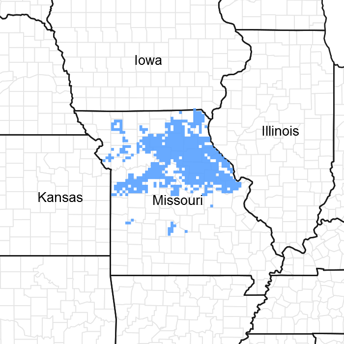
Figure 1. Mapped extent
Areas shown in blue indicate the maximum mapped extent of this ecological site. Other ecological sites likely occur within the highlighted areas. It is also possible for this ecological site to occur outside of highlighted areas if detailed soil survey has not been completed or recently updated.
MLRA notes
Major Land Resource Area (MLRA): 113X–Central Claypan Areas
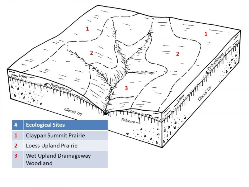
The western, Missouri portion of the Central Claypan (area outlined in red on the map) is a weakly dissected till plain. Elevation ranges from about 1,000 feet in the north along the divide between the Missouri and Mississippi River watersheds to about 625 feet where the North Fork of the Salt River flows out of the area. Relief is generally low, with low slope gradients and relatively narrow drainageways. Most of the Central Claypan is in the Salt River watershed. The characteristic “claypan” occurs in the loess that caps the pre-Illinoisan aged till on the broad interfluves that characterize this region. Till is exposed on lower slopes. The underlying Mississippian aged limestone and Pennsylvanian aged shale is exposed in only a few places along lower slopes above the Salt River.
Classification relationships
Terrestrial Natural Community Type in Missouri (Nelson, 2010):
The reference state for this ecological site is most similar to a Wet-Mesic Bottomland Woodland.
Missouri Department of Conservation Forest and Woodland Communities (Missouri Department of Conservation, 2006):
The reference state for this ecological site is most similar to a Wet Bottomland Forest.
National Vegetation Classification System Vegetation Association (NatureServe, 2010):
The reference state for this ecological site is most similar to Quercus macrocarpa - Quercus palustris - Quercus bicolor / Calamagrostis canadensis Wooded Herbaceous Vegetation (CEGL005120).
Geographic relationship to the Missouri Ecological Classification System (Nigh & Schroeder, 2002):
This ecological site occurs throughout the Claypan Till Plains Subsection, and in adjacent Land Type Associations of the Mississippi River Hills and Chariton River Hills Subsections.
Ecological site concept
NOTE: This is a “provisional” Ecological Site Description (ESD) that is under development. It contains basic ecological information that can be used for conservation planning, application and land management. After additional information is collected, analyzed and reviewed, this ESD will be refined and published as “Approved”.
Wet Upland Drainageway Woodlands (green areas on the map) are scattered throughout the MLRA, particularly in the southeast portion, and adjacent areas. Soils are loamy and wet, and are subject to flooding. The reference plant community is woodland with an overstory dominated by pin oak, bur oak, shellbark hickory, swamp white oak, Shumard oak, and American elm, and a ground flora of native grasses and forbs.
Associated sites
R109XY046MO |
Till Upland Savanna Till Upland Savannas are often upslope. |
---|---|
R113XY002MO |
Loess Upland Prairie Loess Upland Prairies are often upslope. |
Similar sites
F113XY005MO |
Wet Upland Drainageway Woodland There are no similar Wet Upland Drainageway Woodland sites in this MLRA. |
---|
Table 1. Dominant plant species
Tree |
(1) Quercus palustris |
---|---|
Shrub |
Not specified |
Herbaceous |
(1) Carex |
Physiographic features
This site is in narrow drainageways in the uplands, with slopes of 1 to 4 percent. The site receives runoff from adjacent upland sites. Most areas are subject to frequent, brief flooding.
Table 2. Representative physiographic features
Landforms |
(1)
Drainageway
|
---|---|
Flooding duration | Very brief (4 to 48 hours) to brief (2 to 7 days) |
Flooding frequency | Occasional to frequent |
Ponding frequency | None |
Slope | 1 – 4% |
Water table depth | 6 – 12 in |
Aspect | Aspect is not a significant factor |
Climatic features
The western part of the Central Claypan Area MLRA has a continental type of climate marked by strong seasonality. In winter, dry-cold air masses, unchallenged by any topographic barriers, periodically swing south from the northern plains and Canada. If they invade reasonably humid air, snowfall and rainfall result. In summer, moist, warm air masses, equally unchallenged by topographic barriers, swing north from the Gulf of Mexico and can produce abundant amounts of rain, either by fronts or by convectional processes. In some summers, high pressure stagnates over the region, creating extended droughty periods. Spring and fall are transitional seasons when abrupt changes in temperature and precipitation may occur due to successive, fast-moving fronts separating contrasting air masses.
This western part of the MLRA experiences regional differences in climates that grade across the region. The basic gradient for most mean annual climatic characteristics is along a line from north to south. Both mean annual temperature and precipitation exhibit modest gradients along this line.
Mean January minimum temperature follows a north to south gradient. However, mean July maximum temperature shows hardly any geographic variation in the region. Mean July maximum temperatures have a range of only two to three degrees across the region.
Mean annual precipitation also varies along the north to south gradient – lower annual precipitation in the north, somewhat higher in the south. Seasonality in precipitation is very pronounced due to strong continental influences. June precipitation, for example, averages three to four times greater than January precipitation.
During years when precipitation comes in a fairly normal manner, moisture is stored in the top layers of the soil during the winter and early spring, when evaporation and transpiration are low. During the summer months the loss of water by evaporation and transpiration is high, and if rainfall fails to occur at frequent intervals, drought will result. Drought directly influences ecological communities by limiting water supplies, especially at times of high temperatures and high evaporation rates. Drought indirectly affects ecological communities by increasing plant and animal susceptibility to the probability and severity of fire. Frequent fires encourage the development of grass/forb dominated communities and understories.
Superimposed upon the basic MLRA climatic patterns are local topographic influences that create topoclimatic, or microclimatic variations. For example, air drainage at nighttime may produce temperatures several degrees lower in valley bottoms than on side slopes. At critical times during the year, this phenomenon may produce later spring or earlier fall freezes in valley bottoms. Slope orientation is an important topographic influence on microclimate. Summits and south-and-west-facing slopes are regularly warmer and drier, supporting more grass dominated communities than adjacent north- and-east-facing slopes that are cooler and moister that support more woody dominated communities especially the moister valleys in the region. Finally, the cooler microclimate within a canopied forest is measurably different from the climate of a more open and warmer grassland or savanna area.
Source: University of Missouri Climate Center - http://climate.missouri.edu/climate.php; Land Resource Regions and Major Land Resource Areas of the United States, the Caribbean, and the Pacific Basin, United States Department of Agriculture Handbook 296 - http://soils.usda.gov/survey/geography/mlra/
Table 3. Representative climatic features
Frost-free period (average) | 177 days |
---|---|
Freeze-free period (average) | 195 days |
Precipitation total (average) | 46 in |
Figure 2. Monthly precipitation range
Figure 3. Monthly average minimum and maximum temperature
Figure 4. Annual precipitation pattern
Figure 5. Annual average temperature pattern
Climate stations used
-
(1) MOBERLY [USC00235671], Moberly, MO
-
(2) COLUMBIA RGNL AP [USW00003945], Columbia, MO
-
(3) MEXICO [USC00235541], Mexico, MO
-
(4) SHELBINA [USC00237720], Shelbina, MO
Influencing water features
This ecological site is influenced by a seasonal high water table, resulting from a combination of high groundwater levels and slow hydraulic conductivity, which impedes throughflow from precipitation and flood events. The water table is typically near the surface in late fall through spring, receding in the summer.
This site is in the RIVERINE wetlands class of the Hydrogeomorphic (HGM) classification system (Brinson, 1993), and are Emergent Palustrine wetlands (Cowardin et al., 1979).
This ecological site contains first-order streams, which originate from headslope positions at the upper reaches of the units, and are fed from smaller headslopes in the adjacent uplands. The lower reaches of units often contain second-order streams. These streams are ephemeral in most years, with flow in the late fall, winter, and spring months, generally disappearing in the summer, or reduced to isolated pools in the lower reaches. Stream levels typically respond quickly to storm events, especially in watersheds where surface runoff is dominant. Short-duration flooding is common in many areas. Streambeds are typically incised into the surrounding floodplain by as much as 10 feet and may be a sign of an alternative state.
Soil features
These soils have no rooting restriction. The soils were formed under a mixture of woodland and herbaceous vegetation. Organic matter content is generally low. Parent material is alluvium. They have silt loam or silty clay loam surface horizons, and loamy subsoils. They are affected by a seasonal high water table during the spring months. Soil series associated with this site include Belknap, Moniteau, Piopolis, and Twomile.
Table 4. Representative soil features
Surface texture |
(1) Silt loam (2) Silty clay loam |
---|---|
Family particle size |
(1) Loamy |
Drainage class | Poorly drained to somewhat poorly drained |
Permeability class | Very slow to slow |
Surface fragment cover <=3" | Not specified |
Surface fragment cover >3" | Not specified |
Available water capacity (0-40in) |
7 – 8 in |
Calcium carbonate equivalent (0-40in) |
Not specified |
Electrical conductivity (0-40in) |
2 mmhos/cm |
Sodium adsorption ratio (0-40in) |
Not specified |
Soil reaction (1:1 water) (0-40in) |
4.5 – 6.5 |
Subsurface fragment volume <=3" (Depth not specified) |
Not specified |
Subsurface fragment volume >3" (Depth not specified) |
Not specified |
Ecological dynamics
Information contained in this section was developed using historical data, professional experience, field reviews, and scientific studies. The information presented is representative of very complex vegetation communities. Key indicator plants, animals and ecological processes are described to help inform land management decisions. Plant communities will differ across the MLRA because of the naturally occurring variability in weather, soils, and aspect. The Reference Plant Community is not necessarily the management goal. The species lists are representative and are not botanical descriptions of all species occurring, or potentially occurring, on this site. They are not intended to cover every situation or the full range of conditions, species, and responses for the site.
Wet Upland Drainageway Woodlands occupy the narrow drainageways below Upland Loess or Till Prairies and Savannas. They have loamy to clayey soil textures and are seasonally wet, due to high water table during the spring months and frequent but brief flooding, consequently limiting the density of trees creating a woodland structure.
Historically, Wet Upland Drainageway Woodlands were dominated by a wide variety of deciduous hardwood tree species, tolerant of seasonally wet conditions. These included pin oak, bur oak, shellbark hickory, swamp white oak, Shumard oak, and American elm. Both historically and today, these woodlands are structurally and compositionally diverse, with occasional tree fall gaps and natural mortality providing opportunities for regeneration of overstory species. In addition, fire played a key role in keeping the canopy and understory open, with a dense ground flora of wet tolerant grasses, sedges and asters.
Today many Wet Upland Drainageway Woodlands have been cleared and converted to agriculture. Where the woodlands still occur, they are denser in the absence of fire, and their composition is usually altered. However, these bands of woodland still play an important role as a source of food and shelter for wildlife. In addition, they are very important in channel stabilization. Some carefully planned timber harvests might be tolerated by this system, but high grading of the timber can also degrade the system.
Re-establishment of these drainage way woodlands is important for stream quality and health, as well as for wildlife. Planting on the appropriate landscape position and soil has proven to be quite successful.
A State and Transition Diagram follows. Detailed descriptions of each state, transition, plant community, and pathway follow the model. This model is based on available experimental research, field observations, professional consensus, and interpretations. It is likely to change as knowledge increases.
State and transition model
Figure 6. State and transition diagram for this ecological s
More interactive model formats are also available.
View Interactive Models
More interactive model formats are also available.
View Interactive Models
Click on state and transition labels to scroll to the respective text
State 1 submodel, plant communities
State 2 submodel, plant communities
State 3 submodel, plant communities
State 4 submodel, plant communities
State 5 submodel, plant communities
State 1
Reference
The historical reference state for this ecological site was old growth bottomland woodland. Natural flooding cycles were the primary processes affecting this ecologic site. Maximum tree age was likely 100 to 200 years. The understory was complex, with multiple layers of shade-tolerant species. A highly diverse ground flora was also present. Vines were common and went well into the canopy. Scattered open areas were common. A change to more frequent, higher-intensity floods on the modern landscape creates more frequent canopy gaps, and introduces or helps to maintain more flood-tolerant species such as sycamore, eastern cottonwood, green ash and hackberry. Over the long term, these floodplains may become more elevated and/or isolated and accumulate more fine sediments, becoming more stable and enduring. Oaks and shellbark hickory begin to accumulate in these later stages of succession. Catastrophic floods will often partially or completely knock down the early species and regenerate this site creating a mosaic of early to late successional floodplain woodlands.
Community 1.1
Pin Oak – Bur Oak//Sedge – Prairie Cord Grass
This phase has an understory that is complex, with multiple layers of shade-tolerant species. A highly diverse ground flora is also present. Vines are common and go well into the canopy. Scattered open areas are common. Overstory is somewhat open.
Forest overstory. The Forest Overstory Species list is based on commonly occurring species listed in Nelson (2010).
Forest understory. The Forest Understory Species list is based on commonly occurring species listed in Nelson (2010).
Community 1.2
Pin Oak – Bur Oak/Elm - Shellbark Hickory/Sedge – Prairie Cord Grass
In this phase, as the site accumulates more fine sediments, becomes more stable and enduring, with oaks and shellbark hickory begin to accumulate in the over and under story layers.
Forest overstory. The Forest Overstory Species list is based on commonly occurring species listed in Nelson (2010).
Forest understory. The Forest Understory Species list is based on commonly occurring species listed in Nelson (2010).
State 2
Managed Woodland
Where this state remains, it has often been subjected to very selective timber harvests. While these woodland areas may resemble the reference state, the diversity of tree species has been selectively (removal of many oaks) altered. Reducing harvests and extending rotations will cause a transition to community phase 2.2. Eliminating harvests, implementing selective thinning, and allowing long tern succession may allow a return to the reference state where hydrologic regimes are least altered.
Community 2.1
Oak – Elm – Shellbark Hickory /American Bladdernut/ Wildrye
Oak and hickory species are increasing due to fire suppression. Displacement of grasses and forbs is occurring due to shading and competition from the increased densities of oak and hickory saplings. Periodic logging keeps this phase in a younger seral stage of development. Canopy cover ranges from 60 to 85 percent. Most stands are 50 to 80 years of age.
Community 2.2
Oak – Elm – Shellbark Hickory/ Green Ash/ Wildrye
This phase occurs when harvest re-entry and prescribed fire is limited or stopped. Ground cover further diminishes but a richer understory of flowering dogwood, sassafras and serviceberry increases. Canopy cover ranges from 80 to 90 percent. Most stands are 60 to 90 years of age. This phase will transition back to Phase 2.1, if well managed forest harvesting occurs.
State 3
Grassland
Many acres of this ecological site have been converted to non-native grasslands of tall fescue and white clover. This state frequently transitions to a cropland state especially when commodity prices are high. A return to a near-reference state from this state is not recommended. Transitioning to a Managed Woodland state is possible through long-term commitments of time and money.
Community 3.1
Tall Fescue/White Clover
This phase is well managed grassland, composed of non-native cool season grasses and legumes. Grazing and haying is occurring. The effects of long-term liming on soil pH, and calcium and magnesium content, is most evident in this phase. Studies show that these soils have higher pH and higher base status in soil horizons as much as two feet below the surface, relative to poorly managed grassland and to woodland communities (where liming is not practiced).
State 4
High Graded/Grazed Woodland
This state is subjected to uncontrolled grazing and high-graded timber harvests. The grazing will open up the understory and remove much of the diverse ground flora. This can lead to erosion of the topsoil during floods. Grazed units also often undergo timber harvest removing a wide variety of outstanding hardwood trees, further diminishing the structural and compositional diversity. A return to the near-reference state will require a long-term commitment including the elimination of grazing, planting of trees and perhaps shrub and herbaceous species, and very limited targeted timber harvests and thinning.
Community 4.1
Pin Oak – American Elm/Hickory/Sedge - Wildrye
This phase is dominated by pin oak and elm along with other less commercially valuable woody species. Oaks in general are greatly diminished or even removed due to repeated high-grading, timber harvesting of the stand.
State 5
Cropland
Many areas of this ecological site have been converted to row crop agriculture. They can transition to a grassland state. A return to the near-reference state is not practical from this state. Transitioning to a Managed Woodland state may be possible through long-term commitments of time and money.
Community 5.1
Corn, Soybeans, Wheat
This phase has intensive cropping of corn, soybeans, and wheat. Tillage operations generally leave little residue on the surface over winter. Surface drainage has usually been altered.
Additional community tables
Table 5. Community 1.1 forest overstory composition
Common name | Symbol | Scientific name | Nativity | Height (ft) | Canopy cover (%) | Diameter (in) | Basal area (square ft/acre) |
---|---|---|---|---|---|---|---|
Tree
|
|||||||
bur oak | QUMA2 | Quercus macrocarpa | Native | – | 20–30 | – | – |
pin oak | QUPA2 | Quercus palustris | Native | – | 20–30 | – | – |
Shumard's oak | QUSH | Quercus shumardii | Native | – | 10–20 | – | – |
American elm | ULAM | Ulmus americana | Native | – | 10–20 | – | – |
shellbark hickory | CALA21 | Carya laciniosa | Native | – | 10–20 | – | – |
green ash | FRPE | Fraxinus pennsylvanica | Native | – | 10–20 | – | – |
swamp white oak | QUBI | Quercus bicolor | Native | – | 10–20 | – | – |
common hackberry | CEOC | Celtis occidentalis | Native | – | 10–20 | – | – |
bitternut hickory | CACO15 | Carya cordiformis | Native | – | 1–5 | – | – |
pecan | CAIL2 | Carya illinoinensis | Native | – | 1–5 | – | – |
Table 6. Community 1.1 forest understory composition
Common name | Symbol | Scientific name | Nativity | Height (ft) | Canopy cover (%) | |
---|---|---|---|---|---|---|
Grass/grass-like (Graminoids)
|
||||||
prairie cordgrass | SPPE | Spartina pectinata | Native | – | 10–30 | |
sweet woodreed | CIAR2 | Cinna arundinacea | Native | – | 5–20 | |
fowl mannagrass | GLST | Glyceria striata | Native | – | 5–20 | |
soft fox sedge | CACO13 | Carex conjuncta | Native | – | 5–20 | |
Gray's sedge | CAGR5 | Carex grayi | Native | – | 5–20 | |
false hop sedge | CALU3 | Carex lupuliformis | Native | – | 5–20 | |
hop sedge | CALU4 | Carex lupulina | Native | – | 5–20 | |
squarrose sedge | CASQ2 | Carex squarrosa | Native | – | 5–20 | |
Indian woodoats | CHLA5 | Chasmanthium latifolium | Native | – | 5–20 | |
Forb/Herb
|
||||||
sawtooth sunflower | HEGR4 | Helianthus grosseserratus | Native | – | 10–20 | |
giant ironweed | VEGI | Vernonia gigantea | Native | – | 10–20 | |
swamp verbena | VEHA2 | Verbena hastata | Native | – | 10–20 | |
smallspike false nettle | BOCY | Boehmeria cylindrica | Native | – | 10–20 | |
jewelweed | IMCA | Impatiens capensis | Native | – | 10–20 | |
pale touch-me-not | IMPA | Impatiens pallida | Native | – | 10–20 | |
Canadian clearweed | PIPU2 | Pilea pumila | Native | – | 10–20 | |
bristly buttercup | RAHI | Ranunculus hispidus | Native | – | 10–20 | |
blue skullcap | SCLA2 | Scutellaria lateriflora | Native | – | 10–20 | |
giant goldenrod | SOGI | Solidago gigantea | Native | – | 10–20 | |
wingstem | VEAL | Verbesina alternifolia | Native | – | 10–20 | |
Shrub/Subshrub
|
||||||
roughleaf dogwood | CODR | Cornus drummondii | Native | – | 5–20 | |
Vine/Liana
|
||||||
trumpet creeper | CARA2 | Campsis radicans | Native | – | 10–20 | |
catbird grape | VIPA7 | Vitis palmata | Native | – | 10–20 | |
riverbank grape | VIRI | Vitis riparia | Native | – | 10–20 | |
eastern poison ivy | TORA2 | Toxicodendron radicans | Native | – | 10–20 | |
heartleaf peppervine | AMCO2 | Ampelopsis cordata | Native | – | 10–20 |
Interpretations
Animal community
Wildlife (MDC 2006):
Tall emergent trees along with an uneven canopy structure and canopy gaps associated with this ecological site are important for heron colonies, eagle nesting, Mississippi kites, and other bird species in additional to being important migratory songbird stopover sites.
Ephemeral pools provide important amphibian breeding habitat.
Bird species associated with these sites include Indigo Bunting, Willow Flycatcher, Yellow Warbler, Red-headed Woodpecker, Eastern Wood-Pewee, Great Crested Flycatcher, Tree Swallow, Orchard Oriole, and Baltimore Oriole.
Reptile and amphibian species associated with Floodplain Woodlands include tiger salamander, small-mouthed salamander, midland brown snake, gray treefrog, plains leopard frog, southern leopard frog, and western chorus frog.
(MDC 2006)
Other information
Forestry (NRCS 2002, 2015):
Management: Site index values range from 50 to 90. On the wettest sites, timber management opportunities may be limited. Management of these groups is often difficult because of the great variation in species, age, stocking levels and seasonal wetness. Use seed-tree, group selection, or clear cutting regeneration methods. Maintain adequate riparian buffer areas.
Limitations: Wetness from flooding; seasonal high water table. Use of equipment may be restricted in spring and other excessively wet periods. Restrict activities to dry periods or surfaced areas. Equipment use when wet may compact soil and damage tree roots. Unsurfaced roads and traffic areas tend to be slippery and form ruts easily. Access to forests is easiest during periods in late summer or winter when soils are frozen or dry. Planting is extremely difficult during spring periods. Seedling mortality may be high due to excess wetness. Unsurfaced roads and skid trails may be impassable during rainy periods.
Supporting information
Inventory data references
Plot BAWOPV02 – Piopolis soil (reference)
Located in PRIVATE PROPERTY, Monroe County, MO
Plot TUPRUM04 - Belknap soil (reference)
Located in Tucker Prairie, Callaway County, MO
Latitude: 38.946124
Longitude: -91.999369
Other references
Brinson, M.M. 1993. A hydrogeomorphic classification for wetlands. Technical Report WRP-DE-4, U.S. Army Corps of Engineers, Engineer Waterways Experiment Station, Vicksburg, MS.
Cowardin, L.M., V. Carter, F.C. Golet, & E.T. LaRoe. 1979. Classification of wetlands and deepwater habitats of the United States. U.S. Dept. of Interior, Fish & Wildlife Service, Office of Biological Services, Washington DC.
Missouri Department of Conservation, 2006. Missouri Forest and Woodland Community Profiles. Jefferson City, Missouri.
National Vegetation Classification System Vegetation Association. 2010. http://www.natureserve.org/prodServices/ecomapping.jsp
Natural Resources Conservation Service. 2002. Woodland Suitability Groups. Missouri FOTG, Section II, Soil Interpretations and Reports. 30 pgs.
Natural Resources Conservation Service Site Index Reports. Accessed January 2015. https://esi.sc.egov.usda.gov/ESI_Forestland/pgFSWelcome.aspx
Nelson, Paul W. 2010. The Terrestrial Natural Communities of Missouri. Missouri Department of Conservation, Jefferson City, Missouri.
Nigh, Timothy A., and Walter A. Schroeder. 2002. Atlas of Missouri Ecoregions. Missouri Department of Conservation, Jefferson City, Missouri.
United States Department of Agriculture, Natural Resources Conservation Service. 2006. Land Resource Regions and Major Land Resource Areas of the United States, the Caribbean, and the Pacific Basin. U.S. Department of Agriculture Handbook 296.
University of Missouri Climate Center - http://climate.missouri.edu/climate.php
Young, F. J. & A. W. Geller. 1995. Soil Survey of Audrain County, Missouri. U.S. Dept. of Agric. Natural Resources Conservation Service.
Contributors
Fred Young
Doug Wallace
Acknowledgments
Missouri Department of Conservation and Missouri Department of Natural Resources personnel provided significant and helpful field and technical support in the development of this ecological site.
Rangeland health reference sheet
Interpreting Indicators of Rangeland Health is a qualitative assessment protocol used to determine ecosystem condition based on benchmark characteristics described in the Reference Sheet. A suite of 17 (or more) indicators are typically considered in an assessment. The ecological site(s) representative of an assessment location must be known prior to applying the protocol and must be verified based on soils and climate. Current plant community cannot be used to identify the ecological site.
Author(s)/participant(s) | |
---|---|
Contact for lead author | |
Date | |
Approved by | |
Approval date | |
Composition (Indicators 10 and 12) based on | Annual Production |
Indicators
-
Number and extent of rills:
-
Presence of water flow patterns:
-
Number and height of erosional pedestals or terracettes:
-
Bare ground from Ecological Site Description or other studies (rock, litter, lichen, moss, plant canopy are not bare ground):
-
Number of gullies and erosion associated with gullies:
-
Extent of wind scoured, blowouts and/or depositional areas:
-
Amount of litter movement (describe size and distance expected to travel):
-
Soil surface (top few mm) resistance to erosion (stability values are averages - most sites will show a range of values):
-
Soil surface structure and SOM content (include type of structure and A-horizon color and thickness):
-
Effect of community phase composition (relative proportion of different functional groups) and spatial distribution on infiltration and runoff:
-
Presence and thickness of compaction layer (usually none; describe soil profile features which may be mistaken for compaction on this site):
-
Functional/Structural Groups (list in order of descending dominance by above-ground annual-production or live foliar cover using symbols: >>, >, = to indicate much greater than, greater than, and equal to):
Dominant:
Sub-dominant:
Other:
Additional:
-
Amount of plant mortality and decadence (include which functional groups are expected to show mortality or decadence):
-
Average percent litter cover (%) and depth ( in):
-
Expected annual annual-production (this is TOTAL above-ground annual-production, not just forage annual-production):
-
Potential invasive (including noxious) species (native and non-native). List species which BOTH characterize degraded states and have the potential to become a dominant or co-dominant species on the ecological site if their future establishment and growth is not actively controlled by management interventions. Species that become dominant for only one to several years (e.g., short-term response to drought or wildfire) are not invasive plants. Note that unlike other indicators, we are describing what is NOT expected in the reference state for the ecological site:
-
Perennial plant reproductive capability:
Print Options
Sections
Font
Other
The Ecosystem Dynamics Interpretive Tool is an information system framework developed by the USDA-ARS Jornada Experimental Range, USDA Natural Resources Conservation Service, and New Mexico State University.
Click on box and path labels to scroll to the respective text.
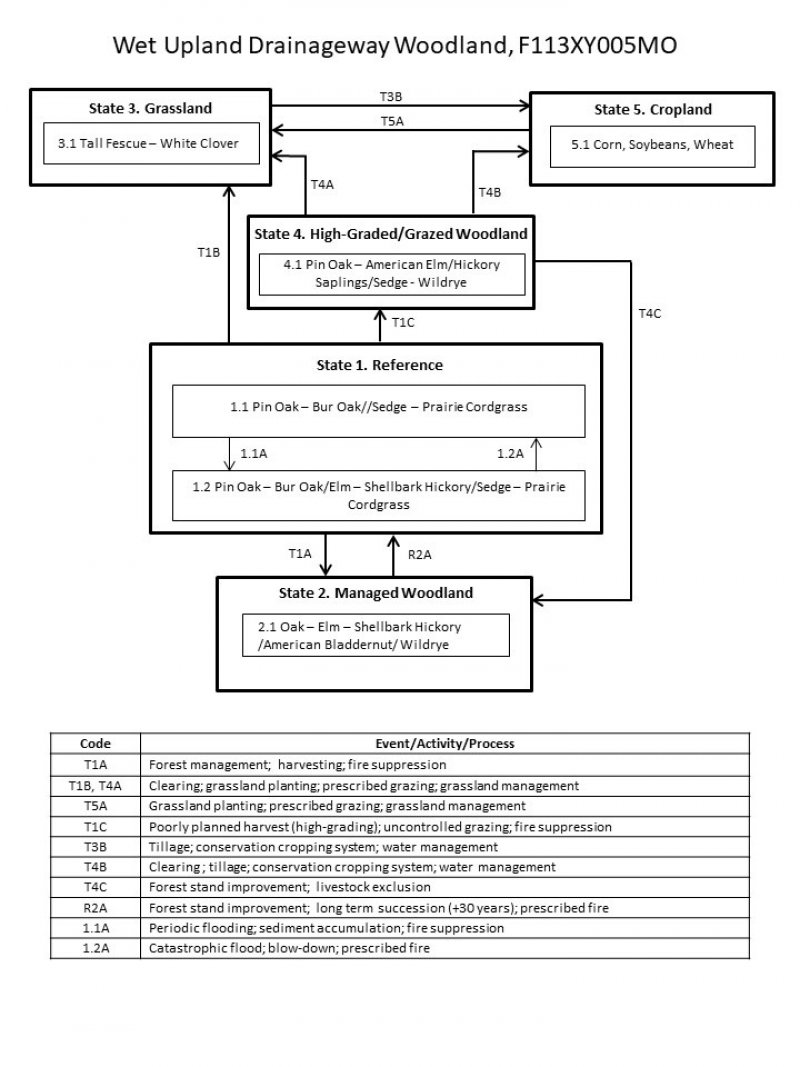