Natural Resources
Conservation Service
Ecological site F113XY910IL
Fragic Backslope Woodland
Last updated: 5/17/2024
Accessed: 02/06/2026
General information
Provisional. A provisional ecological site description has undergone quality control and quality assurance review. It contains a working state and transition model and enough information to identify the ecological site.
MLRA notes
Major Land Resource Area (MLRA): 113X–Central Claypan Areas
The eastern Illinois portion of the Central Claypan Areas MLRA is in the Till Plains Section of the Central Lowland Province of the Interior Plains (USDA-NRCS, 2006) and includes the Southern Till Plain Natural Division of the natural divisions of Illinois (Schwegman, 1973; 1997; IDNR, 2018) in south-central Illinois. South-central Illinois is a dissected Illinoisan till plain south of the terminal Wisconsin moraine. This region consists of nearly level to gently sloping, old till plains. Stream valleys are shallow and generally are narrow. Elevation is about 660 feet (200 meters), increasing gradually from south to north. Local relief is generally low on the broad, flat till plains and flood plains and high on the dissected hills bordering rivers or drainage systems. The Kaskaskia, Little Muddy, Little Wabash, Embarras, and Saline Rivers are part of this area. This region is covered with loess, which overlies old glacial drift (Illinoisan till) that has a high content of clay. Fragipans are also present. Pennsylvanian limestone and shale bedrock underlay the glacial till. The dominant soil orders in this region are Alfisol and Mollisol. The soils in the area predominantly have a mesic soil temperature regime, an aquic or udic soil moisture regime, and mixed or smectitic mineralogy. They generally are very deep, well drained to poorly drained, and loamy or clayey. (USDA-NRCS, 2006).
Classification relationships
Major Land Resource Area (MLRA) (USDA-NRCS, 2006):
113 – Central Claypan Areas, Eastern Part
U.S. Forest Service Ecoregions (Cleland et al. 2007):
Domain: Humid Temperate Domain
Division: Hot Continental Division
Province: Eastern Broadleaf Forest (Continental)
Province Code: 222
Section: Central Till Plains, Oak-Hickory Section
Section Code: 222G
Ecological site concept
This woodland community type is found in south-central Illinois in the Central Claypan Areas MLRA. Fragic Backslope ecological sites are found on convex backslopes along drainageways in dissected uplands along transitional areas between broad summit ecological sites and steeper hillslope ecological sites. They formed in loess and the underlying silty or loamy deposits that overlie a strongly developed paleosol with a shallow to moderately deep fragipan.
The historic reference plant community was a woodland dominated by drought and fire-tolerant post oak (Quercus stellata Wangenh.)1 and black oak (Quercus velutina Lam.) and hickory species (Carya spp.), including shagbark hickory (Carya ovata (Mill.) K. Koch) and mockernut hickory (Carya tomentosa (Lam.) Nutt.) (White, 1978). Saplings of sassafras (Sassafras albidum (Nutt.) Nees) and black cherry (Prunus serotina Ehrh.) may be present. The herbaceous layer probably contained a fairly diverse mix of prairie and woodland flora, with prairie grasses, such as little bluestem (Schizachyrium scoparium (Michx.) Nash), abundant. Few sites remain on which to describe this type, and historically, it may have been maintained by frequent fires (NatureServ, 2017). McClain et al. (1999) note that this type occurs in the post oak flatwoods region of Illinois, but stands of this type lack the micro-depressions typical of post oak flatwoods, nor do they contain the typical indicators of the xero-hydric conditions of flatwoods, such as sweet woodreed (Cinna arundinacea L.).
Woodlands were distinguished from forest, by their relatively open understory, and the presence of sun-loving ground flora species (White, 1994). Fire was the primary disturbance factor that maintained this ecological site, while drought, windthrow, and grazing were secondary factors (LANDFIRE 2009).
1 All plant common and scientific names in this document were obtained from the U.S. Department of Agriculture – Natural Resources Conservation Service National PLANTS Database (USDA NRCS, 2018).
Associated sites
| R113XY904IL |
Upland Prairie Prairie ecological site often upslope but on dark colored somewhat poorly drained soils associated with nearly level till plains. |
|---|---|
| F113XY911IL |
Loamy Till Backslope Forest A backslope woodland ecological site on loess over till loamy soils that is sometimes mapped in a complex with Fragic Backslope Woodlands. |
Similar sites
| F113XY907IL |
Fragic Till Plain Woodland Fragic Till Plain Woodland ecological sites are upslope, also support an oak-hickory woods, but poorer drainage results in a wetter environment that is less productive with more moisture tolerant species in the understory. |
|---|
Table 1. Dominant plant species
| Tree |
(1) Quercus stellata |
|---|---|
| Shrub |
(1) Rhus aromatica |
| Herbaceous |
(1) Schizachyrium scoparium |
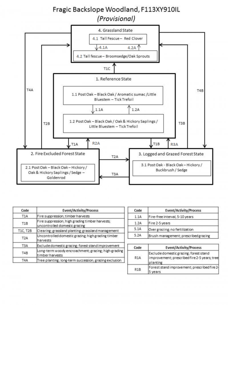
Click on box and path labels to scroll to the respective text.
| T1A | - | Fire suppression; timber harvests |
|---|---|---|
| T1B | - | Fire suppression; high grading timber harvests; uncontrolled domestic grazing |
| T1C | - | Clearing; grassland planting; grassland management |
| R2A | - | Forest stand improvement; prescribed fire 2-5 years |
| T2A | - | Uncontrolled domestic grazing; high grading timber harvests |
| T2B | - | Clearing; grassland planting; grassland management |
| R3A | - | Exclude domestic grazing; forest stand improvement; prescribed fire 2-5 years; tree planting |
| T3A | - | Exclude domestic grazing; forest stand improvement |
| T3B | - | Clearing; grassland planting; grassland management |
| T4A | - | Tree planting; long-term succession; grazing exclusion |
| T4B | - | Long-term woody encroachment; grazing; high-grading timber harvests |
