Natural Resources
Conservation Service
Ecological site R113XY002MO
Loess Upland Prairie
Last updated: 5/17/2024
Accessed: 11/23/2024
General information
Provisional. A provisional ecological site description has undergone quality control and quality assurance review. It contains a working state and transition model and enough information to identify the ecological site.

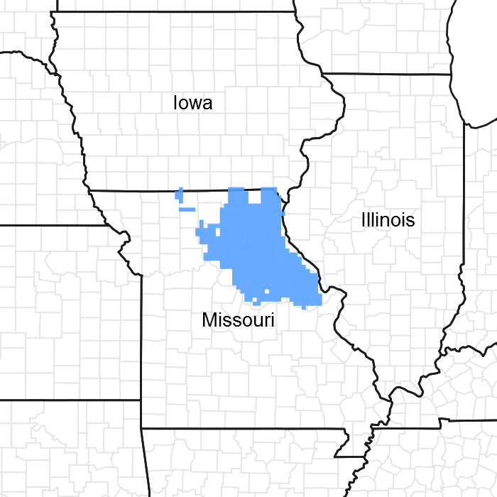
Figure 1. Mapped extent
Areas shown in blue indicate the maximum mapped extent of this ecological site. Other ecological sites likely occur within the highlighted areas. It is also possible for this ecological site to occur outside of highlighted areas if detailed soil survey has not been completed or recently updated.
MLRA notes
Major Land Resource Area (MLRA): 113X–Central Claypan Areas
The western, Missouri portion of the Central Claypan is a weakly dissected till plain. Elevation ranges from about 1,000 feet in the north along the divide between the Missouri and Mississippi River watersheds to about 625 feet where the North Fork of the Salt River flows out of the area. Relief is generally low, with low slope gradients and relatively narrow drainageways. Most of the Central Claypan is in the Salt River watershed. The characteristic “claypan” occurs in the loess that caps the pre-Illinoisan aged till on the broad interfluves that characterize this region. Till is exposed on lower slopes. The underlying Mississippian aged limestone and Pennsylvanian aged shale is exposed in only a few places along lower slopes above the Salt River.
Classification relationships
Terrestrial Natural Community Type in Missouri (Nelson, 2010):
The reference state for this ecological site is most similar to a Dry-Mesic Loess/Glacial Till Prairie.
National Vegetation Classification System Vegetation Association (NatureServe, 2010):
The reference state for this ecological site is most similar to Schizachyrium scoparium - Sorghastrum nutans - Bouteloua curtipendula Herbaceous Vegetation (CEGL002214).
Geographic relationship to the Missouri Ecological Classification System (Nigh & Schroeder, 2002):
This ecological site occurs throughout the Claypan Till Plains Subsection, and in adjacent Land Type Associations of the Wyaconda River Dissected Till Plains and Chariton River Hills Subsections.
Ecological site concept
NOTE: This is a “provisional” Ecological Site Description (ESD) that is under development. It contains basic ecological information that can be used for conservation planning, application and land management. After additional information is collected, analyzed and reviewed, this ESD will be refined and published as “Approved”.
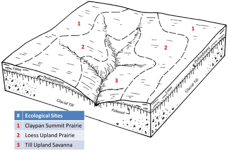
Loess Upland Prairies occur throughout the MLRA and adjacent areas. They are typically downslope from Claypan Summit Prairie ecological sites, and upslope from Till Upland Savanna sites. Soils are wet and seepy in the spring, which affects species composition. The reference plant community is prairie dominated by Indiangrass, big bluestem, little bluestem and sideoats grama, and a wide variety of prairie wildflowers.
Associated sites
| F113XY005MO |
Wet Upland Drainageway Woodland Wet Upland Drainageway Woodlands are downslope. |
|---|---|
| R109XY046MO |
Till Upland Savanna Till Upland Savannas are often downslope. |
| R113XY001MO |
Claypan Summit Prairie Claypan Summit Prairies are upslope, on broad summits. |
Similar sites
| R113XY001MO |
Claypan Summit Prairie Claypan Summit Prairies are similar in overall species composition but are typically found on gentler slopes above this ecological site. |
|---|
Table 1. Dominant plant species
| Tree |
Not specified |
|---|---|
| Shrub |
(1) Amorpha canescens |
| Herbaceous |
(1) Andropogon gerardii |
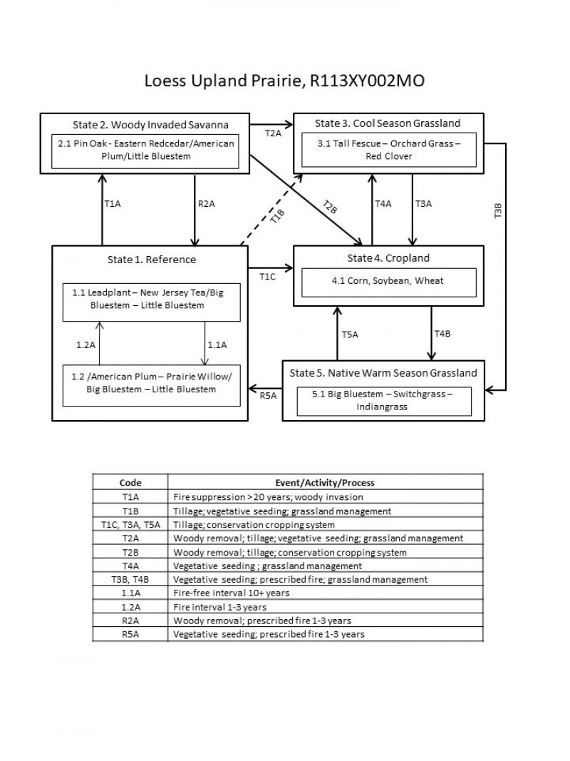
Click on box and path labels to scroll to the respective text.
Ecosystem states
States 1 and 5 (additional transitions)
| T1A | - | Fire suppression > 20 years; woody invasion. |
|---|---|---|
| T1B | - | Tillage, vegetative seeding; grassland management. |
| T1C | - | Tillage; conservation cropping system. |
| R2A | - | Vegetative seeding; prescribed fire 1-3 years. |
| T2A | - | Woody removal; tillage; vegetative seeding; grassland management |
| T2B | - | Woody removal; tillage; conservation cropping system. |
| T3A | - | Tillage; conservation cropping system. |
| T4A | - | Vegetative seeding; grassland management |
| T4B | - | Vegetative seeding; prescribed fire; grassland management |
| R5A | - | Vegetative seeding; prescribed fire 1-3 years |
| T5A | - | Tillage; conservation cropping system |
State 1 submodel, plant communities
| 1.1A | - | Fire free interval 10+ years |
|---|---|---|
| 1.2A | - | Fire interval 1-3 years |

