Natural Resources
Conservation Service
Ecological site F115XB051MO
Sandstone Exposed Backslope Woodland
Last updated: 12/30/2024
Accessed: 02/08/2026
General information
Provisional. A provisional ecological site description has undergone quality control and quality assurance review. It contains a working state and transition model and enough information to identify the ecological site.
Figure 1. Mapped extent
Areas shown in blue indicate the maximum mapped extent of this ecological site. Other ecological sites likely occur within the highlighted areas. It is also possible for this ecological site to occur outside of highlighted areas if detailed soil survey has not been completed or recently updated.
MLRA notes
Major Land Resource Area (MLRA): 115X–Central Mississippi Valley Wooded Slopes
This MLRA is characterized by deeply dissected, loess-covered hills bordering well defined valleys of the Illinois, Mississippi, Missouri, Ohio, and Wabash Rivers and their tributaries. It is used to produce cash crops and livestock. About one-third of the area is forested, mostly on the steeper slopes. This area is in Illinois (50 percent), Missouri (36 percent), Indiana (13 percent), and Iowa (1 percent) in two separate areas. It makes up about 25,084 square miles (64,967 square kilometers).
Most of this area is in the Till Plains section and the Dissected Till Plains section of the Central Lowland province of the Interior Plains. The Springfield-Salem plateaus section of the Ozarks Plateaus province of the Interior Highlands occurs along the Missouri River and the Mississippi River south of the confluence with the Missouri River. The nearly level to very steep uplands are dissected by both large and small tributaries of the Illinois, Mississippi, Missouri, Ohio, and Wabash Rivers. The Ohio River flows along the southernmost boundary of this area in Indiana. Well defined valleys with broad flood plains and numerous stream terraces are along the major streams and rivers. The flood plains along the smaller streams are narrow. Broad summits are nearly level to undulating. Karst topography is common in some parts along the Missouri and Mississippi Rivers and their tributaries. Well-developed karst areas have hundreds of sinkholes, caves, springs, and losing streams. In the St. Louis area, many of the karst features have been obliterated by urban development.
Elevation ranges from 90 feet (20 meters) on the southernmost flood plains to 1,030 feet (320 meters) on the highest ridges. Local relief is mainly 10 to 50 feet (3 to 15 meters) but can be 50 to 150 feet (15 to 45 meters) in the steep, deeply dissected hills bordering rivers and streams. The bluffs along the major rivers are generally 200 to 350 feet (60 to 105 meters) above the valley floor.
The uplands in this MLRA are covered almost entirely with Peoria Loess. The loess can be more than 7 feet (2 meters) thick on stable summits. On the steeper slopes, it is thin or does not occur. In Illinois, the loess is underlain mostly by Illinoian-age till that commonly contains a paleosol. Pre-Illinoian-age till is in parts of this MLRA in Iowa and Missouri and to a minor extent in the western part of Illinois. Wisconsin-age outwash, alluvial deposits, and sandy eolian material are on some of the stream terraces and on dunes along the major tributaries. The loess and glacial deposits are underlain by several bedrock systems. Pennsylvanian and Mississippian bedrock are the most extensive. To a lesser extent are Silurian, Devonian, Cretaceous, and Ordovician bedrock. Karst areas have formed where limestone is near the surface, mostly in the southern part of the MLRA along the Mississippi River and some of its major tributaries. Bedrock outcrops are common on the bluffs along the Mississippi, Ohio, and Wabash Rivers and their major tributaries and at the base of some steep slopes along minor streams and drainageways.
The annual precipitation ranges from 35 to 49 inches (880 to 1,250 millimeters) with a mean of 41 inches (1,050 millimeters). The annual temperature ranges from 48 to 58 degrees F (8.6 to 14.3 degrees C) with a mean of 54 degrees F (12.3 degrees C). The freeze-free period ranges from 150 to 220 days with a mean of 195 days.
Soils The dominant soil orders are Alfisols and, to a lesser extent, Entisols and Mollisols. The soils in the area have a mesic soil temperature regime, an aquic or udic soil moisture regime, and mixed or smectitic mineralogy. They are shallow to very deep, excessively drained to poorly drained, and loamy, silty, or clayey.
The soils on uplands in this area support natural hardwoods. Oak, hickory, and sugar maple are the dominant species. Big bluestem, little bluestem, and scattered oak and eastern redcedar grow on some sites. The soils on flood plains support mixed forest vegetation, mainly American elm, eastern cottonwood, river birch, green ash, silver maple, sweetgum, American sycamore, pin oak, pecan, and willow. Sedge and grass meadows and scattered trees are on some low-lying sites. (United States Department of Agriculture, Natural Resources Conservation Service, 2022)
LRU notes
The Central Mississippi Valley Wooded Slopes, Western Part consists of deeply dissected, loess-covered hills bordering the Missouri and Mississippi Rivers as well as floodplains and terraces of these rivers. The Northern boundary runs along the South Fabius River valley separating it from the broad rounded interfluves of the northern till plain. A major physiographic feature within the LRU (Land Resource Unit) includes the Lincoln Hills region. The Lincoln Hills extend along the Mississippi River in Missouri, starting about 40 miles (64 kilometers) northwest of St. Louis and extending north to Hannibal. The Lincoln Hills partially escaped the most recent glaciation in the region during the Pleistocene. In geology and biology, they resemble the rugged and forested hills of the Ozark Highlands (MLRA 116A) more than the rolling plains of northern Missouri. The underlying limestone bedrock has formed bluffs, glades, caves, springs, and sinkholes. Elevation ranges from about 420 feet (128 meters) along the Mississippi River near Cape Girardeau, Missouri to about 830 feet (253 meters) near Clarksville along the Mississippi River upstream from St. Louis. High ridges near Hillsboro, Missouri can reach over 1,000 feet (305 meters). Underlying bedrock is mainly Ordovician-aged dolomite and sandstone, with Mississippian-aged limestone north of the Missouri River. Loess caps both stream and glacial outwash terraces along the major rivers along with Pre-Illinoisan till near the edges of the area.
Classification relationships
Major Land Resource Area (MLRA) (USDA-NRCS, 2022):
115X–Central Mississippi Valley Wooded Slopes
Terrestrial Natural Community Type in Missouri (Nelson, 2010):
The reference state for this ecological site is most similar to a Dry-Mesic Sandstone Woodland.
Missouri Department of Conservation Forest and Woodland Communities (MDC, 2006):
The reference state for this ecological site is most similar to a Mixed Oak Woodland.
National Vegetation Classification System Vegetation Association (NatureServe, 2010):
The reference state for this ecological site is most similar to a Quercus alba - Quercus stellata - Quercus velutina / Schizachyrium scoparium Woodland (CEGL002150).
Geographic relationship to the Missouri Ecological Classification System (Nigh & Schroeder, 2002):
This ecological site occurs in several Land Type Associations of the following Subsections:
Inner Ozark Border
Outer Ozark Border
Ecological site concept
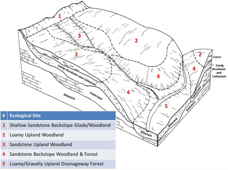
Sandstone Exposed Backslope Woodlands occupy the southerly and westerly aspects of steep, dissected slopes, and are mapped in complex with the Sandstone Protected Backslope Forest ecological site. These sites are inextensive in uplands not adjacent to the Missouri or Mississippi River floodplains, and are associated with the St. Peter and LaMotte sandstone formations. The St.Peter sandstone units are located on lower slopes below Limestone/Dolomite Glade and Woodland ecological sites, while the Lamotte sandstone units are part of a complex of sandstone glades, woodlands and forests. These ecological sites are often downslope from Loamy Upland Woodlands. Soils are typically moderately deep over sandstone bedrock, with an abundance of sandstone fragments in the subsoil. The reference plant community is woodland with an overstory dominated by black oak, with minor amounts of white oak and post oak, and a ground flora of native grasses and forbs.
Associated sites
| F115XB005MO |
Loamy Upland Woodland Loamy Upland Woodland sites underlain by sandstone are often upslope. |
|---|---|
| F115XB016MO |
Sandstone Upland Woodland Sandstone Upland Woodlands are on upper backslopes and shoulders |
| F115XB017MO |
Sandstone Protected Backslope Forest Sandstone Protected Backslope Woodlands are also on steep, dissected slopes but on northerly and easterly aspects. |
| R115XB052MO |
Shallow Sandstone Backslope Glade/Woodland Shallow Sandstone Backslope Glade/Woodland sites are usually closely associated with this site. |
Similar sites
| F115XB017MO |
Sandstone Protected Backslope Forest Sandstone Protected Backslope Woodlands are also on steep, dissected slopes but on northerly and easterly aspects. |
|---|
Table 1. Dominant plant species
| Tree |
(1) Quercus velutina |
|---|---|
| Shrub |
(1) Vaccinium pallidum |
| Herbaceous |
(1) Schizachyrium scoparium |
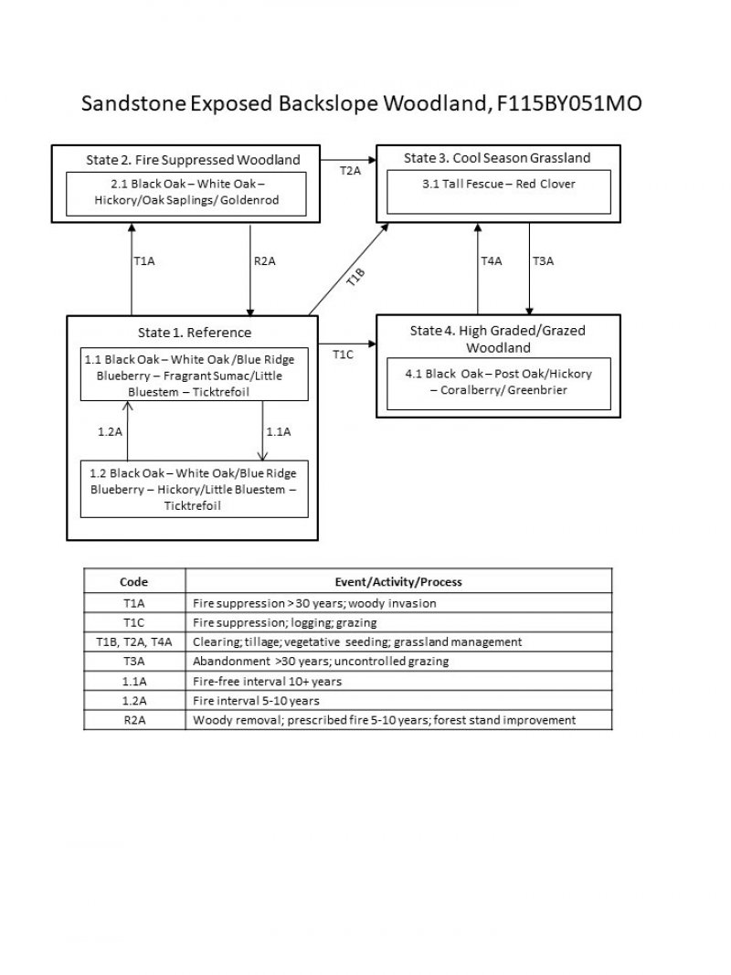
Click on box and path labels to scroll to the respective text.

