
Anthropic Deep Loess Upland

Scenario model
Current ecosystem state
Select a state
Management practices/drivers
Select a transition or restoration pathway
- Transition T1A More details
- Transition T2A More details
-
No transition or restoration pathway between the selected states has been described
Target ecosystem state
Select a state
Description
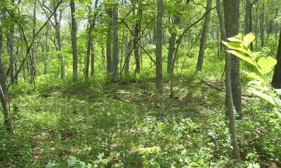
A reference state for this ecological site does not now exist. However, historically, in similar native settings, an analogous ecological site, Deep Loess Upland Woodland, once existed and was a well-developed woodland dominated by an overstory of white oak, along with black oak and an occasional post oak. This state is now highly altered and can no longer be restored.
Submodel
State 2
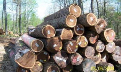
Altered Land Use


Description
This state occurs when the historical reference state is altered through timber harvesting or clearing with tillage, cropping systems, vegetative seeding, grassland management, implemented creating cropland, grassland, and second growth woodland. This state is now highly altered as the result of intensive human activity.
Submodel
State 3
Anthropogenic (Human-altered land)


Description
This anthropogenic state occurs when the altered land use state is cleared and developed for intensive human use and inhabitation, such as commercial and housing developments, parks, golf courses, and earthen spoils. The vegetation has been removed when present and soils have either been altered in place or transported from one location to another. Most of the soils in this state have 60 to 122 cm (2 to 4 feet) of overburden on top of the natural soil. This natural material can be determined by observing a buried surface horizon or the unaltered subsoil, till, or alluvial parent materials. When areas have been idle for several years natural reseeding can occur, and second-growth forests may develop. This state can be considered a replacement community and will not transition back to the reference analogy state or altered land use state. Two community phases are recognized in this state, with shifts between phases based on disturbance/idle frequency.
Submodel
Mechanism
This state transitions to state 2 through timber harvesting and clearing; once cleared, activities such as tillage, cropping system, vegetative seeding, and/or grassland management occurs.
Model keys
Briefcase
Add ecological sites and Major Land Resource Areas to your briefcase by clicking on the briefcase (![]() ) icon wherever it occurs. Drag and drop items to reorder. Cookies are used to store briefcase items between browsing sessions. Because of this, the number of items that can be added to your briefcase is limited, and briefcase items added on one device and browser cannot be accessed from another device or browser. Users who do not wish to place cookies on their devices should not use the briefcase tool. Briefcase cookies serve no other purpose than described here and are deleted whenever browsing history is cleared.
) icon wherever it occurs. Drag and drop items to reorder. Cookies are used to store briefcase items between browsing sessions. Because of this, the number of items that can be added to your briefcase is limited, and briefcase items added on one device and browser cannot be accessed from another device or browser. Users who do not wish to place cookies on their devices should not use the briefcase tool. Briefcase cookies serve no other purpose than described here and are deleted whenever browsing history is cleared.
Ecological sites
Major Land Resource Areas
The Ecosystem Dynamics Interpretive Tool is an information system framework developed by the USDA-ARS Jornada Experimental Range, USDA Natural Resources Conservation Service, and New Mexico State University.