Natural Resources
Conservation Service
Ecological site F116CY009MO
Fragipan Basin Woodland
Last updated: 9/24/2020
Accessed: 04/02/2025
General information
Provisional. A provisional ecological site description has undergone quality control and quality assurance review. It contains a working state and transition model and enough information to identify the ecological site.

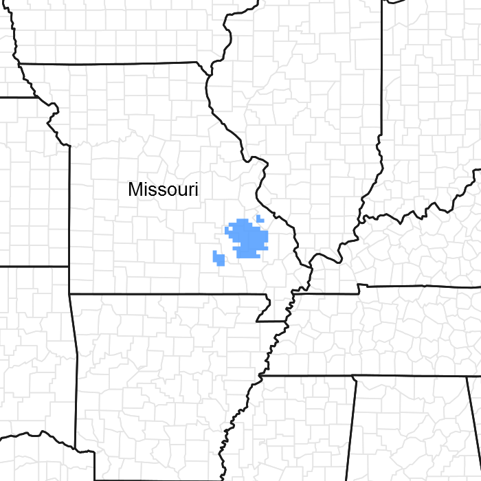
Figure 1. Mapped extent
Areas shown in blue indicate the maximum mapped extent of this ecological site. Other ecological sites likely occur within the highlighted areas. It is also possible for this ecological site to occur outside of highlighted areas if detailed soil survey has not been completed or recently updated.
MLRA notes
Major Land Resource Area (MLRA): 116C–St. Francois Knobs and Basins
The St Francois Knobs and Basins is the structural center of the Ozark Dome. Elevation ranges from about 450 feet along the rivers in the southern part of the area, to 1,772 feet on the summit of Taum Sauk Mountain, the highest point in Missouri. Prominent features of this MLRA are the Precambrian igneous knobs and hills that rise conspicuously to various elevations, interspersed with smooth-floored basins and valleys overlying dolomite and sandstone. Ecological Sites defined for this MLRA are associated with the igneous parent materials, either in knob or basin positions. Areas influenced primarily by dolomite and/or sandstone are included in ecological sites within MLRA 116A (Ozark Highlands).
Classification relationships
Terrestrial Natural Community Type (Nelson, 2010):
The reference state for this ecological site is most similar to a Dry Igneous Woodland.
Missouri Department of Conservation Forest and Woodland Communities (Missouri Department of Conservation, 2006):
The reference state for this ecological site is most similar to a Mixed Oak Woodland.
National Vegetation Classification System Vegetation Association (NatureServe, 2010):
The reference state for this ecological site is most similar to a Quercus stellata - Quercus marilandica - Quercus velutina - Carya texana / Schizachyrium scoparium Woodland (CEGL002149).
Geographic relationship to the Missouri Ecological Classification System (Nigh & Schroeder, 2002):
This ecological site occurs primarily within the following Land Type Associations:
Roselle Oak Woodland Upland Igneous Plain
St. Francois Igneous Glade/Oak Forest Knobs
Ecological site concept
NOTE: This is a “provisional” Ecological Site Description (ESD) that is under development. It contains basic ecological information that can be used for conservation planning, application and land management. As additional information is collected, analyzed and reviewed, this ESD will be refined and published as “Approved”.
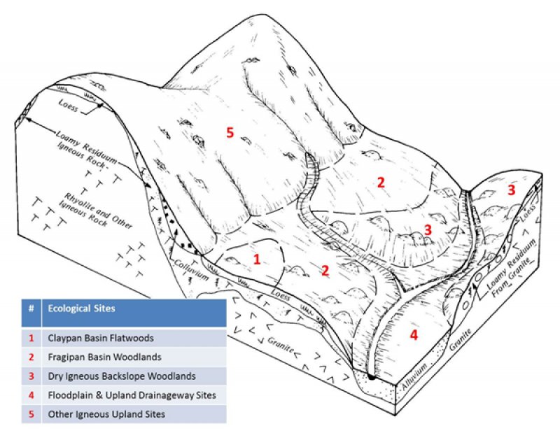
Fragipan Basin Woodlands occur throughout the area, and on outlying igneous knobs and basins in adjacent counties. Soils have root-restricting fragipans. These sites are often adjacent to Claypan Basin Flatwood ecological sites, which are in broad concave positions and are wetter. Fragipan Basin sites are typically adjacent to many of the upland Igneous woodland and forest site, none of which have a root-restricting fragipan. The reference plant community is woodland with an overstory dominated by post oak, with blackjack oak, hickory, white oak, and black oak, and a ground flora of wet-tolerant grasses, sedges, and forbs.
Associated sites
| F116CY004MO |
Igneous Protected Backslope Forest Igneous Protected Backslope Forests are on steeper slopes, and do not have a root-restricting fragipan. |
|---|---|
| F116CY003MO |
Dry Igneous Upland Woodland Dry Igneous Upland Woodlands are generally on steeper slopes, and have bedrock within the soil profile. |
| F116CY005MO |
Dry Igneous Protected Backslope Woodland Igneous Protected Backslope Woodlands are on steeper slopes, and have bedrock within the soil profile. |
| F116CY008MO |
Claypan Basin Flatwoods Claypan Basin Flatwoods are on lower, more concave positions within the basin landscape. |
| F116CY010MO |
Igneous Exposed Backslope Woodland Igneous Exposed Backslope Woodlands are on steeper slopes, and do not have a root-restricting fragipan. |
| F116CY011MO |
Dry Igneous Exposed Backslope Woodland Dry Igneous Exposed Backslope Woodlands are on steeper slopes, and have bedrock within the soil profile. |
| F116CY002MO |
Igneous Upland Woodland Igneous Upland Woodlands are generally on steeper slopes, and do not have a root-restricting fragipan. |
Similar sites
| F116CY003MO |
Dry Igneous Upland Woodland Dry Igneous Upland Woodlands are generally on steeper slopes, and have bedrock within the soil profile but have similar canopy structure and composition. |
|---|
Table 1. Dominant plant species
| Tree |
(1) Quercus stellata |
|---|---|
| Shrub |
(1) Hypericum hypericoides |
| Herbaceous |
(1) Schizachyrium scoparium |
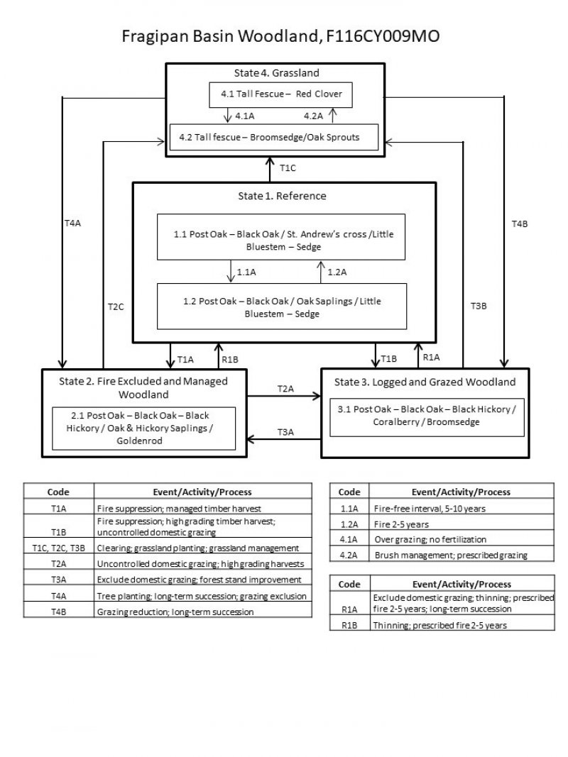
Click on box and path labels to scroll to the respective text.

