Natural Resources
Conservation Service
Ecological site F120BY008IN
Loamy Skeletal Uplands
Last updated: 10/01/2024
Accessed: 02/11/2026
General information
Provisional. A provisional ecological site description has undergone quality control and quality assurance review. It contains a working state and transition model and enough information to identify the ecological site.
MLRA notes
Major Land Resource Area (MLRA): 120B–Kentucky and Indiana Sandstone and Shale Hills and Valleys, Northwestern Part
120B-Kentucky and Indiana Sandstone and Shale Hills and Valleys, Northwestern Part is located in Indiana and covers about 3,040 sq.mi. This area is in the Highland Rim Section of the Interior Low Plateaus Province of the Interior Plains. Tributaries of the Ohio River dissect the uplands. The major streams and rivers have well defined valleys with broad flood plains and numerous stream terraces. The geologic materials in this area are of Early and Middle Pennsylvanian and Late Mississippian age. The rocks consist mainly of flat-lying, interbedded sandstone, shale, coal, and siltstone with minor areas of limestone. Bedrock outcrops are common on river bluffs. The dominant soil orders in this MLRA are Alfisols, Ultisols, and Inceptisols. The soils in the area have a mesic soil temperature regime, a udic or aquic soil moisture regime, and dominantly mixed mineralogy. They formed dominantly in less than 40 inches of loess and in residuum or colluvium derived from sandstone, shale, and siltstone. The soils range from moderately deep to very deep and from poorly drained to somewhat excessively drained and are loamy, silty, or clayey. Fragiudalfs (Apalona, Zanesville) and Hapludalfs (Wellston) are the dominant soils on ridgetops and upper slopes. Hapludults (Adyeville) and Dystrudepts (Tipsaw) are on side slopes, and Hapludults (Tulip) are on footslopes. Hapludalfs (Deuchars, Ebal, Kitterman) are on structural benches and scarps. Endoaquepts (Zipp), Epiaqualfs (McGary), and Hapludalfs (Shircliff, Markland) are formed in lacustrine sediments. Hapludults (Millstone), Hapludalfs (Elkinsville), Fragiudalfs (Sciotoville), and Epiaqualfs (Hatfield) are on terraces along the Ohio River. Hapludolls (Huntington), Eutrudepts (McAdoo, Lindside), and Endoaquepts (Newark) are on flood plains along the major streams. Dystrudepts (Cuba, Steff), Eutrudepts (Gatchel, Haymond), Endoaquepts (Belknap, Stendal), and Fluvaquents (Birds, Bonnie) are on local flood plains.
Classification relationships
Black Oak - White Oak - (Pignut Hickory, Shagbark Hickory) Forest CEGL004987.
Ecological site concept
The Loamy Skeletal Uplands ecological sites are found in loamy -skeletal soil on hillsides and ridges. Representative soils include: Berks, Jubin.
The communities described in this provisional document reflect plant communities that are likely to be found on these soils and have not been field verified. This PES describes hypotheses based on available data of many different scales and sources and has not been developed utilizing site-specific ecological field monitoring. This PES does not encompass the entire complexity or diversity of these sites. Field studies would be required to develop a comprehensive and science-based restoration plan for these sites.
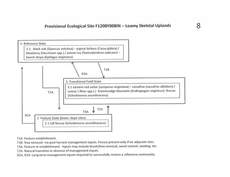
State 1, Phase 1.1.
Forestland. Plant species dominants:
Black oak (Quercus velutina) – pignut hickory (Carya glabra) / blueberry (Vaccinium spp.) / poison ivy (Toxicodendron radicans) – beech drops (Epifagus virginiana)
State 2, Phase 2.1:
Pasture. Plant species dominants:
Schedonorus arundinaceus (tall fescue).
Species present would be dependent upon seeding and management.
State 3, Phase 3.1:
The transitional phase plant community composition will depend upon previous land uses – pasture type, management while in pasture (high quality pasture versus minimal managed grass-shrub –sapling community), and adjacent seed sources. State 3 listed below is assuming a transition from a fescue pasture. This phase is best described as an old field habitat with a mixture of native and introduced grasses and a variety of native and non-native herbs, forbs, seedlings, and saplings. Nearby available seed sources will greatly influence the makeup of this successional community.
Transitional (abandoned) field. Plant species dominants:
eastern red cedar (Juniperus virginiana) – sassafras (sassafras albidum) / sumac ( Rhus spp.) / broomsedge bluestem (Andropogon virginicus) -fescue (Schedonorus arundinaceus)
Due to the shallow soils and high slope percentages, cropland was not included as a major state in this ecological model.
Restoration of states to the reference community would require long-term, intensive management inputs.
Similar sites
| F120BY008IN |
Loamy Skeletal Uplands Loamy Skeletal Uplands |
|---|
Table 1. Dominant plant species
| Tree |
(1) Quercus velutina |
|---|---|
| Shrub |
(1) Vaccinium |
| Herbaceous |
(1) Toxicodendron radicans |
Click on box and path labels to scroll to the respective text.
