
Natural Resources
Conservation Service
Ecological site F133BY015TX
Swamp
Last updated: 12/13/2023
Accessed: 04/18/2025
General information
Provisional. A provisional ecological site description has undergone quality control and quality assurance review. It contains a working state and transition model and enough information to identify the ecological site.
MLRA notes
Major Land Resource Area (MLRA): 133B–Western Coastal Plain
Major Land Resource Area (MLRA) 133B, Western Coastal Plain is in eastern Texas, western Louisiana, and the southwest corner of Arkansas. The area is dominated by coniferous forest covering 45,450 square miles (29,088,000 acres). The region is a hugely diverse transition zone between the eastern deciduous forests and the central grasslands to the west.
Classification relationships
NatureServe, 2002
- I.B.2.N.e.22 – Bald Cypress – (Water Tupelo, Swamp Blackgum, Ogeechee Tupelo) Seasonally Flooded Forest Alliance (A.337)
Soil Survey Staff, 2011
- Woodland Suitability Group – 4w6 Bottomlands
USDA-Natural Resources Conservation Service, 2006.
-Major Land Resource Area (MLRA) 133B
Van Kley et. al., 2007
- 23xxx.4.3.20 – Baldcypress/Ceratophyllum Clayey Semi-Permanently Flooded Swamps Landtype Phase
Ecological site concept
The Swamp ecological site has very deep, very poorly drained soils that are ponded throughout a portion of the year. A wetland plant community exists because it is the lowest position on the landscape, along with the flooding and ponding regimes.
Associated sites
| F133BY012TX |
Wet Terrace Sites are on a higher terrace landscape and are not as wet. |
|---|---|
| F133BY013TX |
Terrace Sites are on a higher terrace landscape and are not as wet. |
Similar sites
| F133BY018TX |
Clayey Bottomland Sites are located in bottomlands and do not stay flooded or ponded as long. |
|---|---|
| F133BY017TX |
Loamy Bottomland Sites are located in bottomlands and do not stay flooded or ponded as long. |
Table 1. Dominant plant species
| Tree |
(1) Taxodium distichum |
|---|---|
| Shrub |
(1) Cephalanthus occidentalis |
| Herbaceous |
(1) Ceratophyllum demersum |
Physiographic features
The ecological site includes areas in low flood plains. They are almost permanently saturated with water and slopes are generally less than 1 percent.
Table 2. Representative physiographic features
| Landforms |
(1)
Coastal plain
> Flood plain
(2) Coastal plain > Swamp |
|---|---|
| Runoff class | Negligible |
| Flooding duration | Long (7 to 30 days) to very long (more than 30 days) |
| Flooding frequency | Frequent to very frequent |
| Ponding duration | Long (7 to 30 days) to very long (more than 30 days) |
| Ponding frequency | Frequent |
| Elevation | 30 – 76 m |
| Slope | 0 – 1% |
| Ponding depth | 0 – 122 cm |
| Water table depth | 0 cm |
| Aspect | Aspect is not a significant factor |
Climatic features
The climate of the Western Coastal Plain (MLRA 133B) is humid subtropical with hot summers and mild winters. Canadian air masses that move southward across Texas and Louisiana over the Gulf of Mexico in winter produce cool, cloudy, rainy weather with only rare cold waves that moderate in one or two days. Precipitation is distributed fairly even throughout the year and is most often in the form of slow and gentle rains.
Spring weather can be variable. March is relatively dry while thunderstorm activities increase in April and May. Occasional slow-moving thunderstorms or other weather disturbances may dump excessive amounts of precipitation on the area. Fall has moderate temperatures. Fall experiences an increase of precipitation and frequently has periods of mild, dry, sunny weather. Heavy rain may occur early in the fall because of tropical disturbances, which move westward from the gulf. Tropical storms are a threat to the area in the summer and fall but severe storms are rare. Prolonged droughts and snowfall are rare.
The total annual precipitation ranges from 39 inches in the western part of the region to 60 inches in the eastern part of the region. Approximately 50 percent of the rainfall occurs between April and September, which includes the growing season for most crops. Thunderstorms occur on about 50 days each year and most occur during the summer.
The average relative humidity in mid-afternoon is about 60 percent. Humidity is higher at night and the average at dawn is about 90 percent. The sun shines 70 percent of the time in summer and 50 percent in winter. The prevailing wind is from the south-southeast. Average wind-speed is highest at 11 miles per hour in spring.
Table 3. Representative climatic features
| Frost-free period (average) | 216 days |
|---|---|
| Freeze-free period (average) | 252 days |
| Precipitation total (average) | 1,270 mm |
Figure 1. Monthly precipitation range
Figure 2. Monthly average minimum and maximum temperature
Figure 3. Annual precipitation pattern
Figure 4. Annual average temperature pattern
Climate stations used
-
(1) MOORINGSPORT 1 N [USC00166364], Mooringsport, LA
-
(2) JEFFERSON [USC00414577], Jefferson, TX
-
(3) ATLANTA [USC00410408], Atlanta, TX
-
(4) DAINGERFIELD 9 S [USC00412225], Daingerfield, TX
Influencing water features
The Swamp is a semi-permanently flooded and may only be exposed to dryer conditions during short periods of the year. These conditions are necessary for recruitment of new bald cypress.
Wetland description
The Swamp is a semi-permanently flooded wetland. The ecological site supports hydrophytic vegetation and the soils are hydric.
Soil features
These soils are very deep, very poorly drained, and very slowly permeable on submerged areas. These soils formed in acidic, clayey alluvial sediments in lake beds, oxbows, and stream channels. Cypress is a representative soil of the Swamps. This ecological site formed from clayey alluvium of Holocene age. The surface horizon is generally a gray clay loam from 0 to 6 inches. he subsurface horizons are typically gray clays from 6 to 20 inches and a secondary subsurface of gray clay 20 to 60 inches. Horizons are gray because of prolonged anoxic conditions and all horizons are sticky and plastic.
Table 4. Representative soil features
| Parent material |
(1)
Alluvium
–
mudstone
|
|---|---|
| Surface texture |
(1) Clay (2) Clay loam |
| Family particle size |
(1) Clayey |
| Drainage class | Very poorly drained |
| Permeability class | Very slow |
| Soil depth | 203 cm |
| Surface fragment cover <=3" | 0% |
| Surface fragment cover >3" | 0% |
| Available water capacity (0-101.6cm) |
15.75 cm |
| Calcium carbonate equivalent (0-101.6cm) |
0% |
| Electrical conductivity (0-101.6cm) |
0 mmhos/cm |
| Sodium adsorption ratio (0-101.6cm) |
0 |
| Soil reaction (1:1 water) (0-101.6cm) |
4 – 5 |
| Subsurface fragment volume <=3" (Depth not specified) |
0% |
| Subsurface fragment volume >3" (Depth not specified) |
0% |
Ecological dynamics
The information in this ecological site description (ESD), including the state-and-transition model (STM), was developed using archeological and historical data, professional experience, and scientific studies. The information is representative of a complex set of plant communities. Not all scenarios or plants are included. Key indicator plants, animals, and ecological processes are described to inform land management decisions.
Introduction – Southern Arkansas, western Louisiana, and eastern Texas have been deemed the Pineywoods because of the vast expanse of pine trees. The region represents the western edge of the southern coniferous belt. Historically, the area was covered by pines with mixed hardwoods, sparse shrubs, and a diverse understory of grasses and forbs. Fire played a significant role in reducing the woody competition that generally out-competes the herbaceous understory layer. Fire suppression and land conversion have reduced the amount of historical communities in existence today.
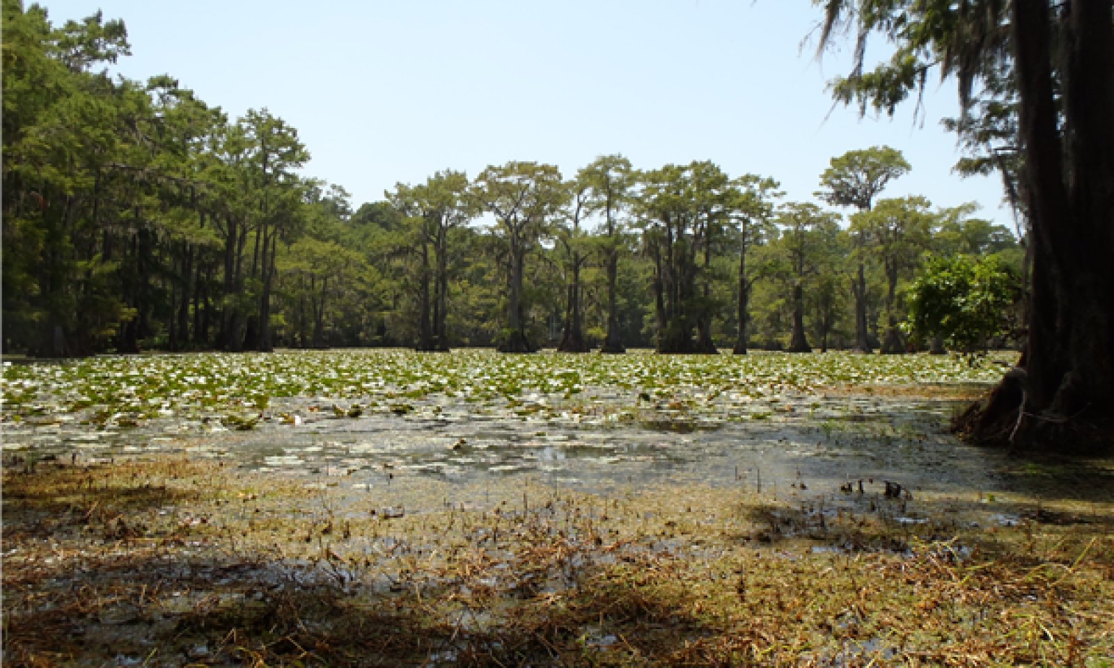
Background – Prior to settlement by the Europeans, the historic plant community for the Clayey Swamp was a bald cypress/buttonbush/coon’s tail (Taxodium distichum/Cephalanthus occidentalis/Ceratophyllum demersum) forest. Remnants of this presumed historic plant community still exist where the historic conditions are still in place. Evidence of the reference state is found in accounts of early historic explorers to the area, historic forest and biological survey teams, as well as recent ecological studies in the last 30 years.
Settlement Management – Unlike much of the Pineywoods region, the Caddo Lake area was not utilized as much for timber and grazing. Instead, the invention of the steamboat in the 19th century provided reason for development. The cities of Port Caddo, Swanson’s Landing, Jefferson, and Mooringsport became thriving riverboat ports. But, as log jams were cleared, the lake level dropped ten feet. This caused the riverboat industry to fail. However, shortly thereafter, oil was discovered in the area and the first oil platform built in 1911. Later the Longhorn Army Ammunition Plant was built in 1942 near the shores of the lake, further adding to change in the area.
Current Management and State – Lake Caddo and its surrounding ecosystems have undergone much change. Today, ecological tourism is the most common land use. Much of the ecological site is within the boundaries of Caddo Lake State Park and Caddo Lake National Wildlife Refuge operated by Texas Parks and Wildlife (TPWD) and the United States Fish and Wildlife Service (USFWS), respectively. Large conservation efforts have taken place in the last 20 years to try and reverse any damage caused by previous human destruction. Currently, the greatest threat to the ecosystem is the invasion of noxious aquatic weeds. The main plant of concern is Giant Salvinia (Salvinia molesta), which spreads by doubling in size every four to ten days under optimal conditions. Efforts to remove the weed include biological control by beetles and the use of herbicides.
Disturbance Regimes – the Clayey Swamp site has adapted to a semi-permanent flooding regime. The site stays inundated with up to four feet of water 75 to 100 percent of the time. At times during the late summer (July to September) some sites may become dry. Otherwise emergent, submergent, and floating aquatic vegetation dominate the site. The effects of fire on the sites are rare because of the wet nature but may have occurred during droughts. Extreme weather events occur occasionally throughout the region. Tornados uproot trees and open canopies in the spring months. In the late summer and early fall, hurricanes or tropical depressions often make landfall, dumping excessive amounts of rain and toppling trees with high winds.
Plant Community Interactions – The dominant force in shaping the swamp is the semi-permanent inundation of water. The hydrology does not allow oxygen to flow through the soil, causing anoxic conditions. Some indicators include: gleyed (grey) soil color with redoximorphic features (reds and yellow intermixed) and the smell of rotten eggs when disturbed (release of hydrogen-sulfide gases). The vegetation has adapted to the anaerobic conditions and these plants are dominant. The United State Army Corps of Engineers (USACOE) classifies plants that occur in wetlands with an estimated probability greater than 99 percent obligate (OBL), and those 67 to 99 percent facultative wetland (FACW) plants. Obligate and facultative wetland plants are the most common encountered throughout the Clayey Swamps. Indicator species are Bald Cypress, buttonbush, coon’s tail, duckweeds (Azolla sp., Lemna sp., and Wolffia sp.), fiddleleaf (Hydrolea uniflora), water lilies (Nupha sp. and Nelumbo sp.), and various sedges (Carex sp.).
State and Transition Diagram -
The following diagram suggests some pathways the vegetative communities may take. Other states may exist that are not shown on the diagram. The information is intended to show what might happen through different circumstances; it does not mean that this would happen the same way in every instance. Changes to the community within a state move back-and-forth easily, but as thresholds are crossed the site changes from state to state. Meaning, changes have progressed to the point where some form of energy is necessary to return the site to the previous state.
State and transition model
More interactive model formats are also available.
View Interactive Models
Click on state and transition labels to scroll to the respective text
Ecosystem states
| T1A | - | Invasion by noxious weed(s) |
|---|---|---|
| R2A | - | Removal of invasives through biological, chemical, or mechanical control |
State 1 submodel, plant communities
| 1.1A | - | Drying and exposure of soil |
|---|---|---|
| 1.1B | - | Windthrow or treefall |
| 1.2A | - | Flooding or inundation |
| 1.2B | - | Windthrow or treefall |
| 1.3A | - | Drying and exposure of soil, overstory regeneration |
State 2 submodel, plant communities
State 1
Bald Cypress Forest
Three community phases exist in the Bald Cypress Forest (1): Submerged Community (1.1), Dry Community (1.2), and No Overstory Community (1.3). The state has a high overstory canopy cover (75 to 95 percent) of bald cypress with planertree (Planera aquatica) and water tupelo (Nyssa aquatica) occurring occasionally. Basal areas usually range from 90 to 110 square feet per acre, but can be difficult to judge because of the buttressing at the base of the bald cypress. Flooding and prolonged inundation in State 1 is common occurring most of the year. Unless extreme drought occurs, the soils may only be dry from July to September.
Community 1.1
Submerged Forest

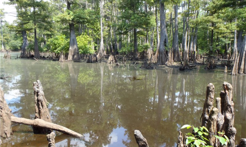
The 1.1 Submerged Community is the most likely encountered phase. The phase is inundated with water up to four feet deep. Floating aquatic vegetation is dominant and all species are hydrophytic. The vegetation has adapted to the oxygen-poor environment in the wetland. In the water column, coon’s tail and longleaf pondweed (Potamogeton nodosus) proliferate. These species reduce the turbidity in the water and provide habitat for invertebrates. Oftentimes the water surface appears to be a green carpet when an abundance of duckweeds exists. Duckweeds (Landoltia sp., and Wolffia sp.) also provide invertebrate habitat but, if too numerous, they can limit the light below the surface. Water lilies (Nuphar lutea) are also common in the ecological site adding to the diversity. In areas where the water is not as deep (0.5 to 2 feet), obligate gramanoids are common. Sedges (Carex sp.) protrude through the water and can be identified by their triangular stems. Buttonbush is almost the only shrub found in the Swamp. The whorled leaf arrangement and ball-shaped fruit can be seen growing out of old bald cypress stumps throughout the understory. Spanish moss (Tillandsia usneoides) readily grows on the leaves of the bald cypress. The Spanish moss absorbs nutrients from the air, rainfall, and the bald cypress because of its high rate of foliar nutrient leaching.
Table 5. Ground cover
| Tree foliar cover | 0-5% |
|---|---|
| Shrub/vine/liana foliar cover | 5-25% |
| Grass/grasslike foliar cover | 5-40% |
| Forb foliar cover | 25-100% |
| Non-vascular plants | 0% |
| Biological crusts | 0% |
| Litter | 0-95% |
| Surface fragments >0.25" and <=3" | 0% |
| Surface fragments >3" | 0% |
| Bedrock | 0% |
| Water | 0-100% |
| Bare ground | 0-35% |
Table 6. Canopy structure (% cover)
| Height Above Ground (m) | Tree | Shrub/Vine | Grass/ Grasslike |
Forb |
|---|---|---|---|---|
| <0.15 | 0-5% | 0-5% | 0-25% | 0-20% |
| >0.15 <= 0.3 | 0-5% | 0-5% | 0-35% | 25-100% |
| >0.3 <= 0.6 | 0-5% | 0-10% | 0-25% | 25-100% |
| >0.6 <= 1.4 | 0-5% | 0-5% | 0-15% | 10-100% |
| >1.4 <= 4 | 0-10% | 5-10% | – | – |
| >4 <= 12 | 5-25% | 5-25% | – | – |
| >12 <= 24 | 25-75% | 5-20% | – | – |
| >24 <= 37 | 50-95% | 5-20% | – | – |
| >37 | – | – | – | – |
Community 1.2
Dry
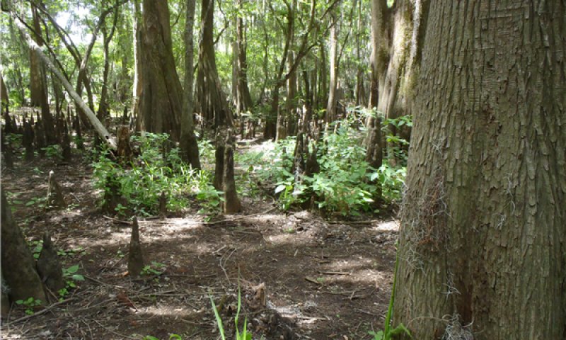
During times of drought and seasonally low precipitation, the Swamp dries out into the Dry Community (1.2). Here the system may be void of surface water, but wetness can usually be found by digging into the soil. This phase may not have surface water, but the plant communities are still comprised of obligate and facultative wetland species. Whitegrass (Leersia virginica), smallspike false nettle (Boehmeria cylindrical), lizard’s tail (Saururus cernuus), and swamp smartweed (Polygonum hydropiperoides) are rapid colonizers. Woody species include water locust (Gleditisa aquatica), black willow (Salix nigra), and common persimmon (Diospyros virginiaca).
Community 1.3
No Overstory
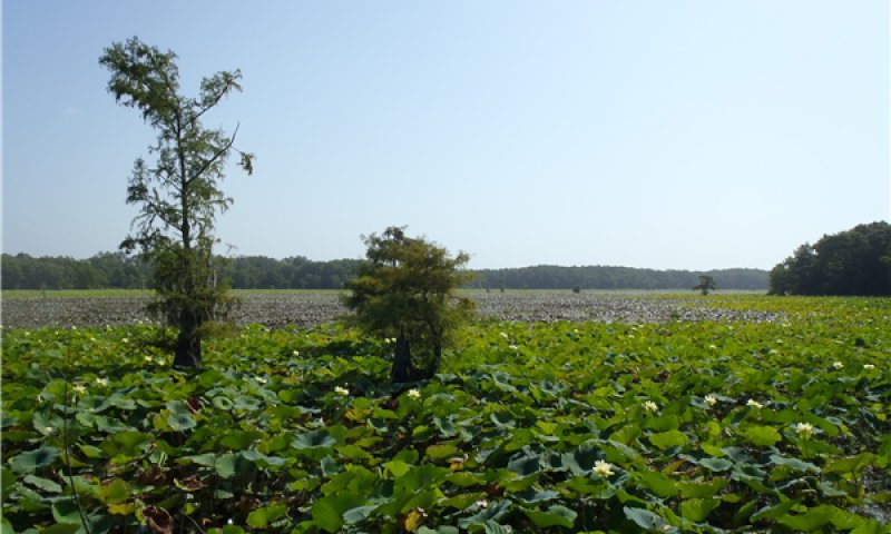
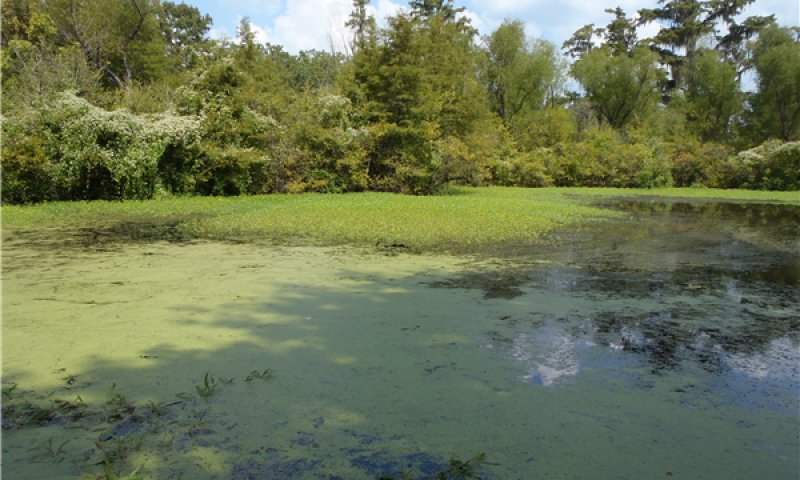
The nature of wet soils does not provide as stable of a rooting environment. Therefore, trees found in the Swamp are susceptible to tree fall, shifting to the 1.3 No Overstory Community. The plants found in this community will be similar to Community 1.1, but slightly more robust because of the additional light exposure. If water levels do not fluctuate and expose soil to the air during the fall, regeneration of overstory trees will not occur. Bald cypress, specifically, needs one to three months of exposed soil to develop while keeping their crowns above floodwaters. Regeneration of fallen overstory around Caddo Lake has become a concern because water levels are controlled by a dam. The water levels do not recede and some areas stay permanently covered in water.
Pathway 1.1A
Community 1.1 to 1.2


The driver for the community shift is drying because of climatic conditions. As evaporation increases and precipitation decreases, soil becomes exposed to air. Longer periods of dryness allow for the colonization of more FACW plants.
Pathway 1.1B
Community 1.1 to 1.3


The driver for the shift is a natural disaster or any other event that would cause an opening in the overstory. Examples include hurricane, wind throw, or severe ice storms.
Pathway 1.2A
Community 1.2 to 1.1


The driver for the community shift is flooding and inundation of the site. Plant species not fully adapted to anoxic conditions will not persist.
Pathway 1.2B
Community 1.2 to 1.3


The driver for the shift is a natural disaster or any other event that would cause an opening in the overstory. Examples include hurricane, wind throw, or severe ice storms.
Pathway 1.3A
Community 1.3 to 1.2


Time and natural regeneration are the drivers for the shift. Natural recruitment begins as good growing conditions exist for overstory tree species. Soil exposure must occur for one to three months during the growing season.
State 2
Invasion
Giant salvinia is small free-floating plant native to South America. It is rapidly growing and able to double in size every four to ten days under good conditions. Colonies that cover the surface cut off light to native plants and can cause oxygen depletions. The depletions are detrimental to an already low-oxygen environment. Further, decomposition of dead salvinia in the water column can further deplete oxygen levels, causing fish kills. Salvinias have no known direct food value to native wildlife.
Community 2.1
Invasion
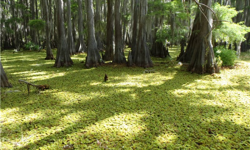
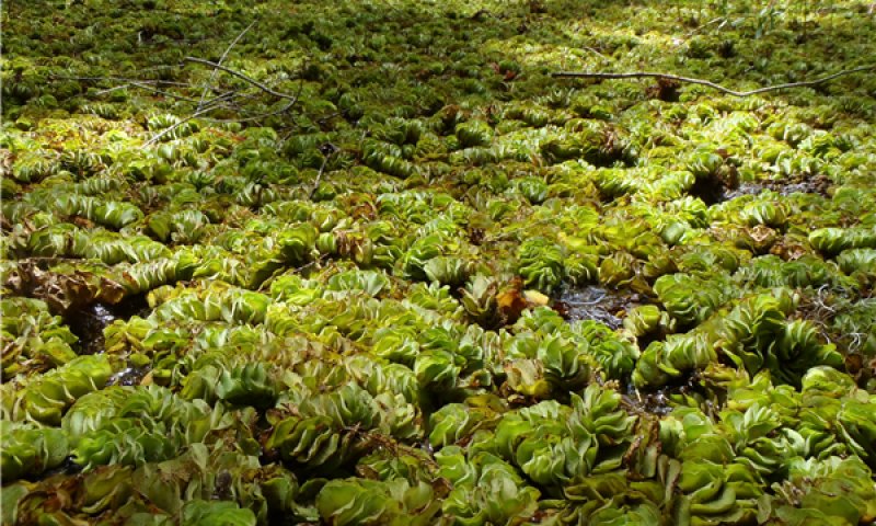
Other aquatic pests include alligatorweed (Alternanthera philoxeroides), waterhyacinth (Eichhornia crassipes), hydrilla (Hydrilla sp.), and Chinese tallow (Triadica sebifera). As with salvinia, these noxious weeds out-compete the native plants. They lack natural control and upset the balance of the natural environment. Control of noxious weeds often proves difficult expending great amounts of energy. Research, federal, and state agencies have devoted a great deal of time in developing management options for the control of these species.
Table 7. Ground cover
| Tree foliar cover | 0-5% |
|---|---|
| Shrub/vine/liana foliar cover | 0-5% |
| Grass/grasslike foliar cover | 0-5% |
| Forb foliar cover | 75-100% |
| Non-vascular plants | 0% |
| Biological crusts | 0% |
| Litter | 5-25% |
| Surface fragments >0.25" and <=3" | 0% |
| Surface fragments >3" | 0% |
| Bedrock | 0% |
| Water | 0-100% |
| Bare ground | 0-5% |
Transition T1A
State 1 to 2
The transition from the Bald Cypress Forest (State 1) to the Invasion State (2) is a result of occupancy by noxious weeds. Most commonly, giant salvinia chokes out all other native species. Other invasive species could include alligatorweed, waterhyacinth, hydrilla, and/or Chinese tallow.
Restoration pathway R2A
State 2 to 1
The driver for restoration is removal of the noxious invasives. Control of the many aquatic invasives is difficult requiring great effort. Mechanical options include seining or raking but the plants will reestablish from any remaining fragments. Biological controls include using triploid grass carp. Permits are required before usage and may be purchased through certified dealers. Salvinia weevils (Cyrtobagous salvinae) have also been used for control. They are natural predators and feed only on salvinia. Biological controls will not completely eradicate invasives, but have proven beneficial in some circumstances. Several chemicals methods are available including diquat, fluridone, glyphosate, penoxsalum, and flumioxazin. Some aquatic herbicides have water use restrictions and can potentially affect non-target species, so labels and restrictions should be studied prior to application. Careful understanding of consequences is necessary before application of any control method.
Additional community tables
Table 8. Community 1.1 forest overstory composition
| Common name | Symbol | Scientific name | Nativity | Height (m) | Canopy cover (%) | Diameter (cm) | Basal area (square m/hectare) |
|---|---|---|---|---|---|---|---|
|
Tree
|
|||||||
| bald cypress | TADI2 | Taxodium distichum | – | – | 90–100 | – | – |
| planertree | PLAQ | Planera aquatica | – | – | 0–10 | – | – |
| water tupelo | NYAQ2 | Nyssa aquatica | – | – | 0–10 | – | – |
Table 9. Community 1.1 forest understory composition
| Common name | Symbol | Scientific name | Nativity | Height (m) | Canopy cover (%) | |
|---|---|---|---|---|---|---|
|
Grass/grass-like (Graminoids)
|
||||||
| giant cutgrass | ZIMI | Zizaniopsis miliacea | – | – | 0–35 | |
| rice cutgrass | LEOR | Leersia oryzoides | – | – | 0–20 | |
| redroot flatsedge | CYER2 | Cyperus erythrorhizos | – | – | 5–15 | |
| cypress swamp sedge | CAJO2 | Carex joorii | – | – | 5–15 | |
| coast cockspur grass | ECWA | Echinochloa walteri | – | – | 0–10 | |
|
Forb/Herb
|
||||||
| coon's tail | CEDE4 | Ceratophyllum demersum | – | – | 5–85 | |
| dotted duckmeat | LAPU12 | Landoltia punctata | – | – | 5–75 | |
| yellow pond-lily | NULU | Nuphar lutea | – | – | 5–75 | |
| American lotus | NELU | Nelumbo lutea | – | – | 5–75 | |
| longleaf pondweed | PONO2 | Potamogeton nodosus | – | – | 5–35 | |
| Columbian watermeal | WOCO | Wolffia columbiana | – | – | 5–35 | |
| marsh seedbox | LUPA | Ludwigia palustris | – | – | 3–35 | |
| oneflower false fiddleleaf | HYUN | Hydrolea uniflora | – | – | 3–20 | |
|
Shrub/Subshrub
|
||||||
| common buttonbush | CEOC2 | Cephalanthus occidentalis | – | – | 3–10 | |
|
Tree
|
||||||
| bald cypress | TADI2 | Taxodium distichum | – | – | 0–5 | |
| planertree | PLAQ | Planera aquatica | – | – | 0–5 | |
| water tupelo | NYAQ2 | Nyssa aquatica | – | – | 0–5 | |
|
Vine/Liana
|
||||||
| Spanish moss | TIUS | Tillandsia usneoides | – | – | 5–35 | |
Table 10. Community 1.2 forest understory composition
| Common name | Symbol | Scientific name | Nativity | Height (m) | Canopy cover (%) | |
|---|---|---|---|---|---|---|
|
Grass/grass-like (Graminoids)
|
||||||
| Florida paspalum | PAFL4 | Paspalum floridanum | – | – | 5–35 | |
| whitegrass | LEVI2 | Leersia virginica | – | – | 5–25 | |
| blunt broom sedge | CATR7 | Carex tribuloides | – | – | 3–10 | |
| redroot flatsedge | CYER2 | Cyperus erythrorhizos | – | – | 3–10 | |
|
Forb/Herb
|
||||||
| smallspike false nettle | BOCY | Boehmeria cylindrica | – | – | 10–50 | |
| lizard's tail | SACE | Saururus cernuus | – | – | 10–50 | |
| swamp smartweed | POHY2 | Polygonum hydropiperoides | – | – | 10–50 | |
| whorled marshpennywort | HYVE2 | Hydrocotyle verticillata | – | – | 5–20 | |
| oneflower false fiddleleaf | HYUN | Hydrolea uniflora | – | – | 5–20 | |
| marsh seedbox | LUPA | Ludwigia palustris | – | – | 3–15 | |
| delta arrowhead | SAPL | Sagittaria platyphylla | – | – | 3–10 | |
| greater marsh St. Johnswort | TRWA | Triadenum walteri | – | – | 0–5 | |
|
Shrub/Subshrub
|
||||||
| common buttonbush | CEOC2 | Cephalanthus occidentalis | – | – | 5–40 | |
| water locust | GLAQ | Gleditsia aquatica | – | – | 0–10 | |
| eastern swampprivet | FOAC | Forestiera acuminata | – | – | 0–10 | |
|
Tree
|
||||||
| bald cypress | TADI2 | Taxodium distichum | – | – | 5–15 | |
| planertree | PLAQ | Planera aquatica | – | – | 0–15 | |
| water tupelo | NYAQ2 | Nyssa aquatica | – | – | 0–15 | |
| black willow | SANI | Salix nigra | – | – | 0–10 | |
| common persimmon | DIVI5 | Diospyros virginiana | – | – | 0–5 | |
| overcup oak | QULY | Quercus lyrata | – | – | 0–5 | |
|
Vine/Liana
|
||||||
| Spanish moss | TIUS | Tillandsia usneoides | – | – | 5–25 | |
| American buckwheat vine | BROV4 | Brunnichia ovata | – | – | 0–15 | |
| lanceleaf greenbrier | SMSM | Smilax smallii | – | – | 0–15 | |
Interpretations
Animal community
The historic animal community is relatively similar to the current community in the reference state. One major missing component is the black bear. Black bears were highly prevalent across the Western Coastal Plain. Their reduced numbers are directly correlated with the westward expansion of the European settlers. Like other mobile animals in the area, bears would have used multiple ecological sites. The Clayey Swamp would have provided the bears with nutrition/food in the form of hunting opportunities from the bountiful wildlife species that use the sites. Other apex predators like the mountain lion and wolf have disappeared in a similar manner.
The Clayey Swamps contain a high diversity of animal species. Mature bald cypress produce seeds and are often consumed by squirrels. Other mammals frequenting the area include raccoons, beavers, and the occasional white-tailed deer (more often when dry).
The swamps provide great habitat for reptiles and amphibians, none greater than the alligator. They can be seen floating in the deeper water areas adjacent to shallows. The alligators nest from mid-June to September on dense mats of vegetation in the Clayey Swamps, correlating with seasonal water lows.
Wide arrays of avian species use the ecosystem. Egrets, herons, hawks, and woodpeckers are all common. During the spring migration, warblers collect insects from the trees. Prothonotary warblers, northern parula, and common yellowthroat stay through the summer and breed, while migrating shorebirds use the areas to refuel en route to their artic breeding grounds.
During the fall and winter, the Clayey Swamps are important to waterfowl as they provide high quality habitat. Waterfowl feed on invertebrates and seeds (annuals providing more energy) located in the shallow-water habitats. In 1993, Caddo Lake and its surrounding ecosystem was designated a “wetland of international importance, especially as waterfowl habitat,” under the Ramsar Preservation Convention.
Recreational uses
The ecological site attracts people and wildlife alike. Bird watching, fishing, hiking, canoeing, kayaking, photography, and hunting are all popular activities in the Clayey Swamp.
Wood products
Pines are used for all types of wood products. Hardwoods are suitable for use as pulpwood, firewood, charcoal, lumber, furniture, railroad ties, and pallet material.
Supporting information
Inventory data references
These site descriptions were developed as part a Provisional Ecological Site project using historic soil survey manuscripts, available site descriptions, and low intensity field traverse sampling. Future work to validate the information is needed. This will include field activities to collect low, medium, and high-intensity sampling, soil correlations, and analysis of that data. A final field review, peer review, quality control, and quality assurance review of the will be needed to produce the final document.
Type locality
| Location 1: Harrison County, TX | |
|---|---|
| Latitude | 32° 39′ 32″ |
| Longitude | 94° 7′ 20″ |
Other references
Ajilvsgi, G. 2003. Wildflowers of Texas. Revised edition. Shearer Publishing, Fredericksburg, TX.
Ajilvsgi, G. 1979. Wildflowers of the Big Thicket. Texas A&M University Press, College Station, TX.
Allen, J. A., B. D. Keeland, J. A. Stanturf, and A. F. Kennedy Jr. 2001. A guide to bottomland hardwood restoration. Technical report,
USGS/BRD/ITR-2000-0011.
Bray, W. L. 1904. Forest resources of Texas. Bureau of Forestry Bulletin 47, Government Printing Office, Washington D.C.
Diggs, G. M., B. L. Lipscomb, M. D. Reed, and R. J. O’Kennon. 2006. Illustrated flora of East Texas. Second edition. Botanical Research
Institute of Texas & Austin College, Fort Worth, TX.
Jones, S. D., J. K. Wipff, and P. M. Montgomery. 1997. Vascular plants of Texas: a comprehensive checklist including synonymy,
bibliography, and index. University of Texas Press, Austin.
NatureServe. 2002. International classification of ecological communities: Terrestrial vegetation of the United States. National forests in
Texas final report. NatureServe, Arlington, VA.
Nixon, E. S. 2000. Trees, shrubs & woody vines of East Texas. Second edition. Bruce Lyndon Cunningham Productions, Nacogdoches, TX.
Picket, S. T. and P. S. White. 1985. The ecology of natural disturbance and patch dynamics. Academic Press, Orlando, FL.
Randall, J. M., and J. Marinelli. 1996. Invasive plants: weeds of the global garden. Volume 149. Brooklyn Botanic Garden, Brooklyn, NY.
Roberts, O. M. 1881. A description of Texas, its advantages and resources with some account of their development past, present and future.
Gilbert Book Company, Saint Louis, MO.
Soil Survey Staff, Natural Resources Conservation Service, United States Department of Agriculture. Soil Survey Geographic (SSURGO)
Database.
Stanturf, J. A., S. H. Schoenholtz, C. J. Schweitzer, and J. P. Shepard. 2001. Achieving restoration success: Myths in bottomland hardwood
forests. Restoration Ecology, 9:189-200.
Stringham, T. K., W. C. Krueger, and P. L. Shaver. 2003. State and transition modeling: An ecological process approach. Journal of Range
Management 56:106-113.
Truett, J. C. 1984. Land of bears and honey: A natural history of East Texas. The University of Texas Press, Austin, TX.
U.S. Army Corps of Engineers. 2010. Regional supplement to the Corps of Engineers Wetland Delineation Manual: Atlantic and Gulf
Coastal Plain Region (Version 2.0). U.S. Army Corps of Engineers, Engineer Research and Development Center, Environmental Laboratory
ERDC/EL TR-10-20.
USDA-NRCS Ag Handbook 296 (2006).
Van Kley, J. E., R. L. Turner, L. S. Smith, and R. E. Evans. 2007. Ecological classification system for the national forests and adjacent areas of the West Gulf Coastal Plain. Second approximation. Stephen F. Austin University and The Nature Conservancy, Nacogdoches, TX.
Vines, R. A. 1960. Trees, shrubs, and woody vines of the Southwest. University of Texas Press, Austin, TX.
Watson, G. E. 2006. Big Thicket Plant Ecology. Third Edition. University of North Texas Press, Denton, TX.
Contributors
Tyson Hart
Approval
Bryan Christensen, 12/13/2023
Rangeland health reference sheet
Interpreting Indicators of Rangeland Health is a qualitative assessment protocol used to determine ecosystem condition based on benchmark characteristics described in the Reference Sheet. A suite of 17 (or more) indicators are typically considered in an assessment. The ecological site(s) representative of an assessment location must be known prior to applying the protocol and must be verified based on soils and climate. Current plant community cannot be used to identify the ecological site.
| Author(s)/participant(s) | |
|---|---|
| Contact for lead author | |
| Date | 09/03/2021 |
| Approved by | Bryan Christensen |
| Approval date | |
| Composition (Indicators 10 and 12) based on | Annual Production |
Indicators
-
Number and extent of rills:
-
Presence of water flow patterns:
-
Number and height of erosional pedestals or terracettes:
-
Bare ground from Ecological Site Description or other studies (rock, litter, lichen, moss, plant canopy are not bare ground):
-
Number of gullies and erosion associated with gullies:
-
Extent of wind scoured, blowouts and/or depositional areas:
-
Amount of litter movement (describe size and distance expected to travel):
-
Soil surface (top few mm) resistance to erosion (stability values are averages - most sites will show a range of values):
-
Soil surface structure and SOM content (include type of structure and A-horizon color and thickness):
-
Effect of community phase composition (relative proportion of different functional groups) and spatial distribution on infiltration and runoff:
-
Presence and thickness of compaction layer (usually none; describe soil profile features which may be mistaken for compaction on this site):
-
Functional/Structural Groups (list in order of descending dominance by above-ground annual-production or live foliar cover using symbols: >>, >, = to indicate much greater than, greater than, and equal to):
Dominant:
Sub-dominant:
Other:
Additional:
-
Amount of plant mortality and decadence (include which functional groups are expected to show mortality or decadence):
-
Average percent litter cover (%) and depth ( in):
-
Expected annual annual-production (this is TOTAL above-ground annual-production, not just forage annual-production):
-
Potential invasive (including noxious) species (native and non-native). List species which BOTH characterize degraded states and have the potential to become a dominant or co-dominant species on the ecological site if their future establishment and growth is not actively controlled by management interventions. Species that become dominant for only one to several years (e.g., short-term response to drought or wildfire) are not invasive plants. Note that unlike other indicators, we are describing what is NOT expected in the reference state for the ecological site:
-
Perennial plant reproductive capability:
Print Options
Sections
Font
Other
The Ecosystem Dynamics Interpretive Tool is an information system framework developed by the USDA-ARS Jornada Experimental Range, USDA Natural Resources Conservation Service, and New Mexico State University.
Click on box and path labels to scroll to the respective text.
Ecosystem states
| T1A | - | Invasion by noxious weed(s) |
|---|---|---|
| R2A | - | Removal of invasives through biological, chemical, or mechanical control |
State 1 submodel, plant communities
| 1.1A | - | Drying and exposure of soil |
|---|---|---|
| 1.1B | - | Windthrow or treefall |
| 1.2A | - | Flooding or inundation |
| 1.2B | - | Windthrow or treefall |
| 1.3A | - | Drying and exposure of soil, overstory regeneration |