Natural Resources
Conservation Service
Ecological site F133BY016TX
Sandy Bottomland
Last updated: 9/21/2023
Accessed: 02/06/2026
General information
Provisional. A provisional ecological site description has undergone quality control and quality assurance review. It contains a working state and transition model and enough information to identify the ecological site.

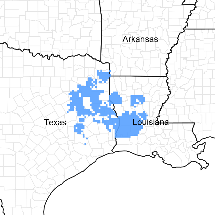
Figure 1. Mapped extent
Areas shown in blue indicate the maximum mapped extent of this ecological site. Other ecological sites likely occur within the highlighted areas. It is also possible for this ecological site to occur outside of highlighted areas if detailed soil survey has not been completed or recently updated.
MLRA notes
Major Land Resource Area (MLRA): 133B–Western Coastal Plain
Major Land Resource Area (MLRA) 133B, Western Coastal Plain is in eastern Texas, western Louisiana, and the southwest corner of Arkansas. Locally termed the Pineywoods, the area is dominated by coniferous forest covering 45,450 square miles (117,770 square kilometers or 29,088,000 acres). The region is a hugely diverse transition zone between the eastern deciduous forests and the central grasslands to the west.
Classification relationships
USDA-Natural Resources Conservation Service, 2006.
-Major Land Resource Area (MLRA) 133B
Ecological site concept
The ecological site has very deep, somewhat poorly drained soils that are occasionally flooded. The sites will typically stay flooded longest during the periods of November to May. Due to their coarse textured soils, the sites drain quicker and do not stay flooded as long as the loamy and clayey bottomlands sites. The drainage patterns and sandy soils create their unique plant community.
Associated sites
| F133BY011TX |
Deep Sandy Terrace Sites are located on a higher terrace position. |
|---|---|
| F133BY012TX |
Wet Terrace Sites are located on a higher terrace position and do not have sandy soils. |
| F133BY013TX |
Terrace Sites are located on a higher terrace position and do not have sandy soils. |
Similar sites
| F133BY018TX |
Clayey Bottomland Sites have clayey soils and flood for longer periods. |
|---|---|
| F133BY014TX |
Creek Bottomland Sites do not flood as often or as long. Sites are typically more narrow and not as wide. |
| F133BY017TX |
Loamy Bottomland Sites have loamy soils and flood for longer periods. |
Table 1. Dominant plant species
| Tree |
(1) Quercus phellos |
|---|---|
| Shrub |
Not specified |
| Herbaceous |
Not specified |
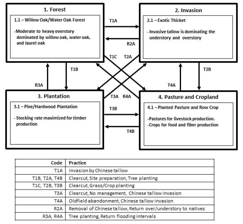
Click on box and path labels to scroll to the respective text.
Ecosystem states
| T1A | - | Invasion by Chinese tallow |
|---|---|---|
| T1B | - | Clearcut, site preparation, tree planting |
| T1C | - | Clearcut, grass/crop planting |
| R2A | - | Removal of Chinese tallow, return over/understory to natives |
| T2A | - | Clearcut, site preparation, tree planting |
| T2B | - | Clearcut, grass/crop planting |
| R3A | - | Tree planting, return flooding intervals |
| T3A | - | Clearcut, no management, Chinese tallow invasion |
| T3B | - | Clearcut, grass/crop planting |
| R4A | - | Tree planting, return flooding intervals |
| T4A | - | Oldfield abandonment, Chinese tallow invasion |
| T4B | - | Clearcut, site preparation, tree planting |
