Natural Resources
Conservation Service
Ecological site F134XY203AL
Western Alkali Flatwoods - PROVISIONAL
Last updated: 3/24/2025
Accessed: 04/11/2025
General information
Provisional. A provisional ecological site description has undergone quality control and quality assurance review. It contains a working state and transition model and enough information to identify the ecological site.
MLRA notes
Major Land Resource Area (MLRA): 134X–Southern Mississippi Valley Loess
The Southern Mississippi Valley Loess (MLRA 134) extends some 500 miles from the southern tip of Illinois to southern Louisiana. This MLRA occurs in Mississippi (39 percent), Tennessee (23 percent), Louisiana (15 percent), Arkansas (11 percent), Kentucky (9 percent), Missouri (2 percent), and Illinois (1 percent). It makes up about 26,520 square miles. Landscapes consist of highly dissected uplands, level to undulating plains, and broad terraces that are covered with a mantle of loess. Underlying the loess are Tertiary deposits of unconsolidated sand, silt, clay, gravel, and lignite. The soils, mainly Alfisols, formed in the loess mantle. Stream systems of the MLRA typically originate as low-gradient drainageways in the upper reaches that broaden rapidly downstream to wide, level floodplains with highly meandering channels. Alluvial soils, mostly Entisols and Inceptisols, are predominantly silty where loess thickness of the uplands are deepest but grade to loamy textures in watersheds covered by thin loess. Crowley’s Ridge, Macon Ridge, and Lafayette Loess Plains are discontinuous, erosional remnants that run north to south in southeastern Missouri - eastern Arkansas, northeastern Louisiana, and south-central Louisiana, respectively. Elevations range from around 100 feet on terraces in southern Louisiana to over 600 feet on uplands in western Kentucky. The steep, dissected uplands are mainly in hardwood forests while less sloping areas are used for crop, pasture, and forage production (USDA-NRCS, 2006).
This site primarily occurs on the terraces of the Western Lowlands Pleistocene Valley Trains (EPA Level IV Ecoregion: 73g; Woods et al., 2004). Additionally, the soils of this site have been mapped locally on low-lying areas of Crowley’s Ridge and to the east on the Northern Holocene Meander Belts (EPA Ecoregion: 73c; Woods et al., 2004). The distribution of this site spans the boundaries of MLRA 134 and MLRA 131A (Southern Mississippi River Alluvium).
Classification relationships
All or portions of the geographic range of this site falls within a number of ecological/land classifications including:
-NRCS Major Land Resource Area (MLRA) 134 – Southern Mississippi Valley Loess
-NRCS Major Land Resource Area (MLRA) 131A – Southern Mississippi River Alluvium
-Environmental Protection Agency’s Level IV Ecoregion: Western Lowlands Pleistocene Valley Trains: 73g (Woods et al., 2004); Pleistocene Valley Trains: 73b (Chapman et al., 2002)
-234A – Southern Mississippi Alluvial Plain section of the USDA Forest Service Ecological Subregion (McNab et al., 2005)
-Alkali Post Oak Flats (Klimas et al., 2012)
-Quercus stellata/Q. marylandica Forest on Saline Soils (Heineke, 1987)
Ecological site concept
The Western Alkali Flatwoods ecological site is characterized by deep, somewhat poorly drained and poorly drained soils that formed in loess or silty, loess-like material. This site occurs on level, Pleistocene-age terraces, active alluvial terraces, and stream floodplains with slopes 0 to 2 percent. Soils of this site are high in exchangeable sodium and are noted for producing poor quality woodlands. Historically, the natural vegetation of this site likely consisted of a mosaic of herbaceous openings that graded to a sparse, post oak woodland community. Occurrences of this site may have been appropriately deemed “deer licks” or “slick spots” due to the high sodium content and open spots of bare ground.
Associated sites
| F134XY209AL |
Western Moderately Wet Terrace - PROVISIONAL |
|---|---|
| F134XY202AL |
Western Wet Loess Terrace - PROVISIONAL |
Similar sites
| F134XY303LA |
West Central Natric Loess Terrace - PROVISIONAL Soils of this site have similar natric properties. |
|---|---|
| F134XY009AL |
Northern Natric Loess Terrace - PROVISIONAL This site occurs east of the Mississippi River and represents the eastern counterpart to the Western Alkali Flatwoods ecological site. |
Table 1. Dominant plant species
| Tree |
(1) Quercus stellata |
|---|---|
| Shrub |
(1) Vaccinium arboreum |
| Herbaceous |
(1) Danthonia spicata |
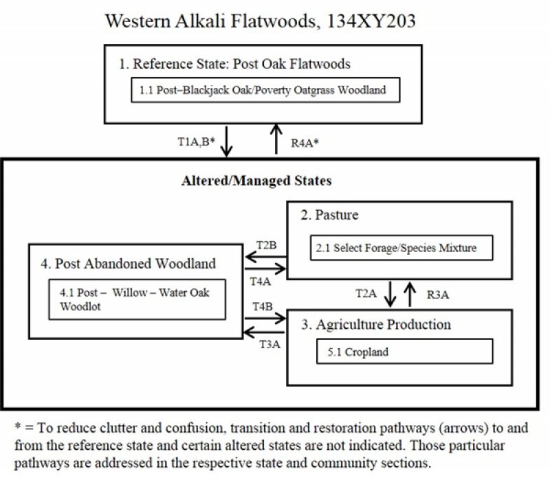
Click on box and path labels to scroll to the respective text.

