Natural Resources
Conservation Service
Ecological site F134XY209AL
Western Moderately Wet Terrace - PROVISIONAL
Last updated: 3/24/2025
Accessed: 02/06/2026
General information
Provisional. A provisional ecological site description has undergone quality control and quality assurance review. It contains a working state and transition model and enough information to identify the ecological site.
MLRA notes
Major Land Resource Area (MLRA): 134X–Southern Mississippi Valley Loess
The Southern Mississippi Valley Loess (MLRA 134) extends some 500 miles from the southern tip of Illinois to southern Louisiana. This MLRA occurs in Mississippi (39 percent), Tennessee (23 percent), Louisiana (15 percent), Arkansas (11 percent), Kentucky (9 percent), Missouri (2 percent), and Illinois (1 percent). It makes up about 26,520 square miles. Landscapes consist of highly dissected uplands, level to undulating plains, and broad terraces that are covered with a mantle of loess. Underlying the loess are Tertiary deposits of unconsolidated sand, silt, clay, gravel, and lignite. The soils, mainly Alfisols, formed in the loess mantle. Stream systems of the MLRA typically originate as low-gradient drainageways in the upper reaches that broaden rapidly downstream to wide, level floodplains with highly meandering channels. Alluvial soils, mostly Entisols and Inceptisols, are predominantly silty where loess thickness of the uplands are deepest but grade to loamy textures in watersheds covered by thin loess. Crowley’s Ridge, Macon Ridge, and Lafayette Loess Plains are discontinuous, erosional remnants that run north to south in southeastern Missouri - eastern Arkansas, northeastern Louisiana, and south-central Louisiana, respectively. Elevations range from around 100 feet on terraces in southern Louisiana to over 600 feet on uplands in western Kentucky. The steep, dissected uplands are mainly in hardwood forests while less sloping areas are used for crop, pasture, and forage production (USDA-NRCS, 2006).
This site primarily occurs on the loess-capped terraces of the Western Lowlands Pleistocene Valley Trains (EPA Level IV Ecoregion: 73g; Woods et al., 2004), although the soils of the site have been mapped on adjoining areas, such as the Grand Prairie ecoregion (EPA 73e).
Classification relationships
All or portions of the geographic range of this site falls within a number of ecological/land classifications including:
-NRCS Major Land Resource Area (MLRA) 134 – Southern Mississippi Valley Loess
-NRCS Major Land Resource Area (MLRA) 131A – Southern Mississippi River Alluvium
-Environmental Protection Agency’s Level IV Ecoregion: Western Lowlands Pleistocene Valley Trains: 73g (Woods et al., 2004); Pleistocene Valley Trains: 73b (Chapman et al., 2002)
-234A – Southern Mississippi Alluvial Plain section of the USDA Forest Service Ecological Subregion (McNab et al., 2005)
-LANDFIRE Biophysical Setting 4515130 and NatureServe Ecological System CES203.193 Lower Mississippi River Flatwoods, respectively (LANDFIRE, 2008; NatureServe, 2009)
-Hardwood Flats, Early Wisconsin Valley Train and Deweyville Terraces (dry phase) (Klimas et al., 2012)
-Bottomland Flatwoods (Nelson, 2005)
Ecological site concept
The Western Moderately Wet Terrace is characterized by very deep, somewhat poorly drained soils that formed in loess or water reworked loess. This site primarily occurs on broad, level to nearly level Pleistocene-age terraces of the Western Lowlands with slopes ranging from 0 to 3 percent. The principal soil of this site has a seasonally high water table from winter to mid-spring in most years that can become quite droughty by late summer. This extreme alteration between saturated and droughty conditions is attributed to a slowly permeable fragipan. The site sometimes occurs in complex or association with seasonally ponded depressions and poorly drained flatwoods (wet phase). The slightly better drainage of this site coupled with a slightly higher position on the landscape supports a drier plant association than its wetter counterpart, the Western Wet Loess Terrace. The natural vegetation of these broad flats possess characteristics that are suggestive of hydroxeric flatwoods; that is, they have seasonally saturated soils, a relatively open understory, and support droughty woodland species on a low, flat landscape. Common to dominant species of many stands include post oak, southern red oak, and shagbark hickory whereas the shallow depressions of this site may be dominated by willow and water oak. Of note, considerable variation in the plant community may occur among and between stands.
Associated sites
| F134XY201AL |
Western Loess Terrace - PROVISIONAL |
|---|---|
| F134XY202AL |
Western Wet Loess Terrace - PROVISIONAL This site occurs in fairly close association with the Western Moderately Wet Terrace. The latter is slightly drier than the wet terrace site. |
| F134XY206AL |
Western Fragipan Terrace - PROVISIONAL |
Similar sites
| F134XY008AL |
Northern Moderately Wet Loess Terrace - PROVISIONAL This site is the eastern counterpart of the Western Moderately Wet Terrace. |
|---|
Table 1. Dominant plant species
| Tree |
Not specified |
|---|---|
| Shrub |
Not specified |
| Herbaceous |
Not specified |
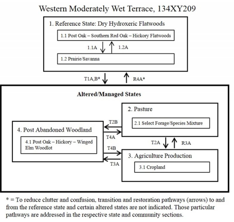
Click on box and path labels to scroll to the respective text.

