Natural Resources
Conservation Service
Ecological site F134XY206AL
Western Fragipan Terrace - PROVISIONAL
Last updated: 3/24/2025
Accessed: 02/06/2026
General information
Provisional. A provisional ecological site description has undergone quality control and quality assurance review. It contains a working state and transition model and enough information to identify the ecological site.

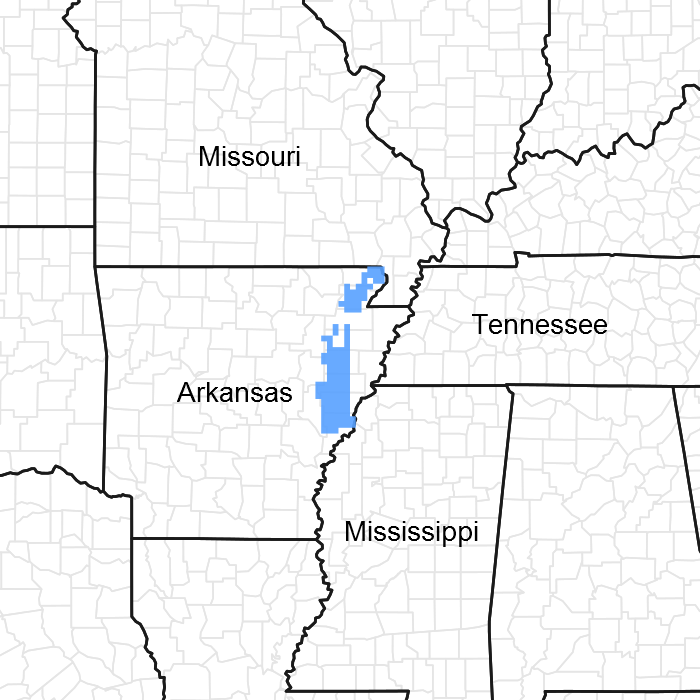
Figure 1. Mapped extent
Areas shown in blue indicate the maximum mapped extent of this ecological site. Other ecological sites likely occur within the highlighted areas. It is also possible for this ecological site to occur outside of highlighted areas if detailed soil survey has not been completed or recently updated.
MLRA notes
Major Land Resource Area (MLRA): 134X–Southern Mississippi Valley Loess
The Southern Mississippi Valley Loess (MLRA 134) extends some 500 miles from the southern tip of Illinois to southern Louisiana. This MLRA occurs in Mississippi (39 percent), Tennessee (23 percent), Louisiana (15 percent), Arkansas (11 percent), Kentucky (9 percent), Missouri (2 percent), and Illinois (1 percent). It makes up about 26,520 square miles. Landscapes consist of highly dissected uplands, level to undulating plains, and broad terraces that are covered with a mantle of loess. Underlying the loess are Tertiary deposits of unconsolidated sand, silt, clay, gravel, and lignite. The soils, mainly Alfisols, formed in the loess mantle. Stream systems of the MLRA typically originate as low-gradient drainageways in the upper reaches that broaden rapidly downstream to wide, level floodplains with highly meandering channels. Alluvial soils, mostly Entisols and Inceptisols, are predominantly silty where loess thickness of the uplands are deepest but grade to loamy textures in watersheds covered by thin loess. Crowley’s Ridge, Macon Ridge, and Lafayette Loess Plains are discontinuous, erosional remnants that run north to south in southeastern Missouri - eastern Arkansas, northeastern Louisiana, and south-central Louisiana, respectively. Elevations range from around 100 feet on terraces in southern Louisiana to over 600 feet on uplands in western Kentucky. The steep, dissected uplands are mainly in hardwood forests while less sloping areas are used for crop, pasture, and forage production (USDA-NRCS, 2006).
The core concepts of this site strictly pertain to the loess-capped terraces of the Western Lowlands Pleistocene Valley Trains (EPA Level IV Ecoregion: 73g; Woods et al., 2004), although the soils of the site have been mapped on uplands and terraces within Crowley’s Ridge physiographic province and to the east on the Northern Holocene Meander Belts (EPA Ecoregion: 73c; Woods et al., 2004).
Classification relationships
All or portions of the geographic range of this site falls within a number of ecological/land classifications including:
-NRCS Major Land Resource Area (MLRA) 134 – Southern Mississippi Valley Loess
-NRCS Major Land Resource Area (MLRA) 131A – Southern Mississippi River Alluvium
-Environmental Protection Agency’s Level IV Ecoregion: Western Lowlands Pleistocene Valley Trains: 73g (Woods et al., 2004)
-234A – Southern Mississippi Alluvial Plain section of the USDA Forest Service Ecological Subregion (McNab et al., 2005)
-LANDFIRE Biophysical Setting 4515130 and NatureServe Ecological System CES203.193 Lower Mississippi River Flatwoods, respectively (LANDFIRE, 2008; NatureServe, 2009)
-Upland Forests of Pleistocene Outwash Terraces and Alluvial Fans (Klimas et al., 2012)
Ecological site concept
The Western Fragipan Terrace is characterized by deep, moderately well drained soils that formed in a mantle of loess. The deep, loessal soils associated with this site were deposited mainly on the higher and older Pleistocene Valley Train terraces of the Western Lowlands. Slopes range from 0 to 8 percent and extend upwards to 12 percent, locally. Topographic features or landforms of this site include low mounds; narrow, linear ridges, and terrace scarps. These prominent positions on the flat terrace landscape never flood but are influenced by seasonal wetness. Soils of this site often perch water during wet seasons and/or high rainfall events due to moderately slow to slow permeability in a dense subsoil layer, typically a fragipan. Historically, the high grounds of this site were likely favored by indigenous people inhabiting the Western Lowlands, and their subsistence and cultural activities would have influenced the surrounding plant communities. Resultantly, a complex mosaic of conditions including forests, open woodlands, and fire-maintained prairies likely existed. Today, this high site is favored for construction and building purposes that include private residences, commercial lots, and cemeteries. Most areas are in agriculture production but few, if any, locations support natural vegetation. Plant species that historically occurred on this site likely consisted of upland hardwoods that included southern red oak, post oak, water oak, and shagbark hickory as dominants with associates of white oak, black gum, and possibly shortleaf pine. Open, fire-influenced areas supported an herbaceous community that consisted of species characteristic of the Grand Prairie ecoregion. Dominant herbaceous species likely consisted of big bluestem, little bluestem, and Indian grass.
Associated sites
| F134XY201AL |
Western Loess Terrace - PROVISIONAL This site occurs in close proximity to the Western Fragipan Terrace but probably does not join or is adjacent to the site. |
|---|---|
| F134XY202AL |
Western Wet Loess Terrace - PROVISIONAL The Western Fragipan Terrace occurs as rises or low terrace ridges on the Western Wet Loess Terrace. |
| F134XY209AL |
Western Moderately Wet Terrace - PROVISIONAL The Western Fragipan Terrace occurs as rises or low terrace ridges on the Western Moderately Wet Terrace. |
Similar sites
| F134XY013AL |
Northern Loess Fragipan Terrace - PROVISIONAL This site is the eastern counterpart to the Western Fragipan Terrace site. |
|---|
Table 1. Dominant plant species
| Tree |
Not specified |
|---|---|
| Shrub |
Not specified |
| Herbaceous |
Not specified |
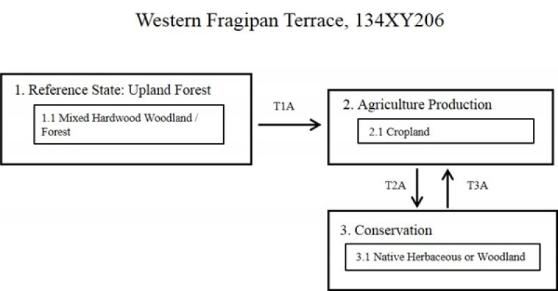
Click on box and path labels to scroll to the respective text.

