Natural Resources
Conservation Service
Ecological site F143XY301ME
Loamy Till Swamp (Northern White Cedar)
Last updated: 10/07/2024
Accessed: 04/26/2025
General information
Provisional. A provisional ecological site description has undergone quality control and quality assurance review. It contains a working state and transition model and enough information to identify the ecological site.
MLRA notes
Major Land Resource Area (MLRA): 143X–Northeastern Mountains
MLRA 143 is in Maine (51 percent), New York (27 percent), Vermont (13 percent), New Hampshire (7 percent), and Massachusetts (2 percent). It makes up about 34,409 square miles (89,118 square kilometers). The MLRA consists of rolling hills and mountains covered by Wisconsin till. It is in three parts separated by other MLRAs. The western part is in New York (primarily the Adirondack Mountains). The central part is mainly in the Green Mountains in Vermont and the Berkshires in Massachusetts. The eastern part is in New Hampshire and most of northern Maine. The MLRA is used mainly for forestry and recreational purposes. The western part of MLRA 143 in the Adirondack Mountains has a distinct boundary with the physiographical dissimilar Saint Lawrence-Champlain Plain. The middle part that encompasses the Green Mountains has a diffuse boundary as it blends into the northern part of the New England and Eastern New York Uplands on the foothills of the Green Mountains. The southern boundary of the easternmost part of MLRA 143 has the same diffuse boundary. The northern boundary of the MLRA is the Canadian border.
The westernmost part of this MLRA is primarily in the Adirondack province of the Appalachian Highlands. A small area in the southern end of the western part is in the Mohawk section of the Appalachian Plateaus province of the same division. The easternmost part, primarily in northern Maine, is in the New England Upland section of the New England province of the Appalachian Highlands. The southwestern half of this part is in the White Mountain section of the same province and division, and the middle part of the MLRA is in the Green Mountain section. The mountains and foothills in this MLRA are commonly rounded. They are underlain by bedrock and typically covered with thin deposits of till. The more rugged mountain areas are separated by high-gradient streams coursing through steep areas of colluvium or talus-laden valleys. Many glacially broadened valleys are filled with glacial outwash and have numerous swamps and lakes. The mountains and foothills are moderately steep to very steep, and the valleys are nearly level to sloping.
As the northernmost MLRA in the region with the coldest temperatures and shortest growing season, the Northeastern Mountains have less overall tree diversity, fewer pine and oak trees, and more abundant spruce and fir trees than neighboring MLRAs. The variability in microtopography on this site results in a patchy mosaic of plant communities. Silver maple is the most common overstory species, with diverse grasses and herbs indicating differences in soil wetness throughout the site due to slight variability in elevation above the water table. This site is subject to ice scour and flooding, but the most extensive disturbance is cultivation. These broad, flat landforms are nutrient rich with high water-holding capacity. These factors along with their adjacency to rivers made them ideal farming locations for early settlers, much of which continues today. The effects of altered flow regimes from modern dams may also be significant but require further study.
LRU notes
LRU concepts have not been developed for MLRA 143. Ecological site groups (ESGs) have been developed for MLRA 143 based on similarities in disturbance response - that is, ecological sites with similar state-and-transition models and similar management considerations are grouped into 9 ESGs. The Loamy Till Swamp site belongs to the wooded wetlands group (ESG 3). Wooded wetlands are poorly- and very poorly-drained soils (with associated somewhat poorly-drained soils) that have sufficient oxygen and nutrients available in the soil to support >40% persistent forest canopy. Wooded wetlands differ from the open wetlands group, which are too wet and/or nutrient poor to support forest stands. Open wetlands are dominated by herbs and shrubs, with only stunted trees or sparse tree canopies (<40% canopy cover).
The wooded wetlands group is particularly susceptible to changes in hydrology that raise or lower the water table and available oxygen and nutrients in the plant rooting zone.
Classification relationships
This site occurs in Ecological Site Group 3 (Wooded Wetlands) of MLRA 143 (The Northeastern Mountains), in the Northeastern Forage and Forest Region (Land Resource Region R).
The Northeastern Forage and Forest LRR includes all of Maine, New Hampshire, Vermont, Rhode Island, and Connecticut, as well as large portions of Massachusetts, New York, New Jersey, Pennsylvania, and Ohio. Its southern boundary marks the extent of the Wisconsin ice sheet, which engulfed the entire LRR as recently as 10,000 to 15,000 years ago. Erosional and depositional processes associated with glaciation created many of the topographic patterns that distinguish MLRAs within the Northeastern region. Harder granitic and metamorphic bedrock to the north were more resistant to glacial erosion, resulting in the relatively nutrient poor mountains of MLRA 143; whereas nutrient-rich sedimentary bedrock of MLRAs 139, 140, and 146 resulted in relatively flat, fertile landscapes ideal for cultivation. Other areas were depressed below sea-level by the sheer mass of the glacier, resulting in pockets of marine sediments which distinguish MLRAs 142, 144A, 144B, and 145.
Precipitation is sufficient to support productive forestland throughout the Northeastern region. Still, a latitudinal temperature gradient from mesic to frigid soil temperatures results in a general transition from central hardwoods and pine in the southern MLRAs to northern hardwoods and spruce-fir forests farther north (no true boreal forests exist in the region). Elevations are generally low throughout the Northeastern region, with the exception of MLRA 143 which has many high mountain ecosystems with cryic temperature regimes and alpine vegetation above the tree line.
Ecological site concept
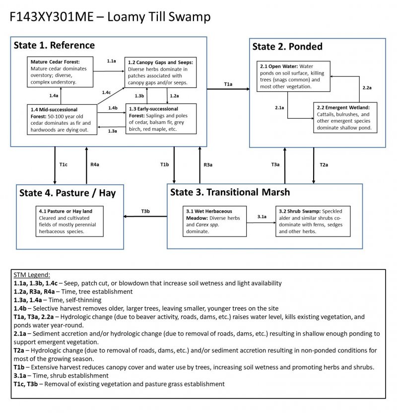
This site occurs on relatively flat to gentle slopes (0-8%) or on toeslopes, where groundwater saturates the soil for much of the growing season and sometimes emerges at the surface. Small seepage rivulets are often evident. Soils formed in lodgment till and are poorly- to very poorly-drained. Soil textures are loamy with a mucky peat surface, and a densely compacted horizon within ~35 inches of the soil surface. The water table is usually within 12 inches of the soil surface in spring, and lowers somewhat in late summer and fall. This site often has pit and mound topography, with ponding and thick organic matter accumulation in the pits, and drier soil conditions with thinner organic matter on the mounds where most trees are rooted.
The reference state is characterized by abundant Northern white cedar. Altered hydrology is the primary driver of state change on this site, with beaver activity and man-made structures that impede drainage (such as roads, dams, etc.) often resulting in ponded or marshland states. This site is also logged in the winter when the ground is frozen, and occasionally used for wet pasture.
Associated sites
| F143XY503ME |
Loamy Flat The Loamy Flat site has poorly-drained soils throughout, while the Loamy Till Swamp typically has both poorly- and very-poorly drained soils. Loamy Flats support red (and black) spruce, while Loamy Till Swamp is typically too wet for red spruce (though it often has black spruce present). |
|---|---|
| F143XY302ME |
Mucky Swamp The Mucky Peat Swamp often occurs downslope of the Loamy Till Swamp as all soils become very poorly drained and soil surface organic layer increases to greater than 16 inches. |
| F143XY502ME |
Loamy Till Toeslope The Loamy Till Toeslope site often occurs upslope of the Loamy Till Swamp, where soils are somewhat poorly- and poorly-drained, rather than poorly- and very poorly-drained. The Loamy Till Toeslope supports hardwood-dominant forests rather than cedar-dominanted forests. |
Similar sites
| F143XY303ME |
Acidic Swamp The Acidic Swamp site has a similar complex of poorly- and very poorly-drained soils, but tends to be wetter, more acidic, and usually has coarser soil textures and weak or non-existent dense compacted layer compared to the Loamy Till Swamp site. The Acidic Swamp is dominated by black spruce rather than northern white cedar. |
|---|---|
| F143XY302ME |
Mucky Swamp Both the Mucky Peat Swamp and the Loamy Till Swamp are dominated by northern white cedar, but the Mucky Peat Swamp is wetter, has a thicker organic soil surface layer, and typically has a more open canopy, allowing more light to reach the forest floor. As a result, the understory is often more productive in the Mucky Peat Swamp. |
Table 1. Dominant plant species
| Tree |
(1) Thuja occidentalis |
|---|---|
| Shrub |
Not specified |
| Herbaceous |
Not specified |


Click on box and path labels to scroll to the respective text.