Natural Resources
Conservation Service
Ecological site F144BY503ME
Loamy Flat
Last updated: 9/27/2024
Accessed: 04/28/2025
General information
Provisional. A provisional ecological site description has undergone quality control and quality assurance review. It contains a working state and transition model and enough information to identify the ecological site.
MLRA notes
Major Land Resource Area (MLRA): 144B–New England and Eastern New York Upland, Northern Part
Major Land Resource Area (MLRA): 144B–New England and Eastern New York Upland, Northern Part
This major land resource area (MLRA) is characterized by plateaus, plains, and mountains. The climate is generally cool and humid with an average annual precipitation of 34 to 62 inches (865 to 1,575 millimeters). The average annual air temperature is typically 40 to 48 degrees F (4 to 9 degrees C). The freeze-free period generally is 130 to 200 days, but it ranges from 110 days in the higher mountains to 240 days in some areas along the Atlantic coast. The soils in this region are dominantly Entisols, Spodosols, and Inceptisols. They commonly have a fragipan. The dominant suborders are Ochrepts, Orthods, Aquepts, Fluvents, and Saprists. The soils in the region dominantly have a frigid soil temperature regime with some cryic areas at higher elevation, a udic soil moisture regime, and mixed mineralogy. Most of the land is forested, and 98 percent is privately owned. Significant amounts of forest products are produced including lumber, pulpwood, Christmas trees, and maple syrup. Principal agricultural crops include forage and grains for dairy cattle, potatoes, apples, and blueberries. Wildlife habitat and recreation are important land uses. Stoniness, steep slopes, and poor drainage limit the use of many of the soils.
Classification relationships
Classification relationships
NRCS:
Land Resource Region: R—Northeastern Forage and Forest Region
MLRA: 144B—New England and Eastern New York Upland, Northern Part
Ecological site concept
This site occurs on flat till plains and ground moraines at elevations between 10 and 2,500 feet. It has a seasonally-high water table, from November through May, that is within 24 inches of the soil surface. From June through October the water table often drops below 24 inches except following large rain events. This site may exhibit pit and mound topography from a history of blowdowns that excavate pits as tree roots tip up and deposit mounds of soil next to the pit.
Soils of this site are poorly- and somewhat-poorly-drained complexes of till, often with a densely-compacted layer 10-25 inches below the surface. This dense layer is hard to dig through and usually has about 15 percent rock fragments (by volume). Importantly, it perches water in the upper soil layers, resulting in redoximorphic features near the soil surface. These are mineral soils, but they may have a layer of mucky peat material on the surface, particularly in poorly-drained depressions.
This site is dominated by red spruce, often with balsam fir occurring in younger patches. Understory is typically sparse, though wild raspberries and other early seral species may occupy large areas when trees are removed by logging, blowdowns, insects or disease.
This site is often managed for spruce-fir timber products, and as such may produce more fir than spruce in a managed state. However, historically these sites were likely dominated by red spruce with a limited understory.
This site includes the following state natural heritage program types:
• Lowland Spruce-fir Forests (Sperduto and Nichols 2004)
• Low Elevation Spruce-fir Forests (Gawler and Cutko 2010)
• Lowland Spruce-fir Forests (Thompson and Sorenson 2000)
Associated sites
| F144BY502ME |
Loamy Till Toeslope The Loamy Flat site and Loamy Till Toeslopes site share many of the same soils, but Loamy Flats occur on flatter areas grading into wetlands and produce spruce-fir forests, whereas the Loamy Till Toeslope occurs at the base of slopes and produces semi-rich mixedwood forests. |
|---|---|
| F144BY301ME |
Loamy Till Swamp The Loamy Till Swamp site occurs lower in the watershed than the Loamy Flat site. The two sites occur together along a soil drainage gradient from somewhat poorly to poorly- and very poorly-drained. |
| F144BY304ME |
Wet Clay Flat The Loamy Flat site occurs on somewhat-poorly and poorly-drained soil complexes that are somewhat drier and have significantly less understory production than the Wet Loamy Flat site. |
Similar sites
| F144BY502ME |
Loamy Till Toeslope The Loamy Flat site and Loamy Till Toeslopes site share many of the same soils, but Loamy Flats occur on flatter areas grading into wetlands and produce spruce-fir forests, whereas the Loamy Till Toeslope occurs at the base of slopes and produces semi-rich mixedwood forests. |
|---|---|
| F144BY304ME |
Wet Clay Flat The Loamy Flat site occurs on somewhat-poorly and poorly-drained soil complexes that are somewhat drier and have significantly less understory production than the Wet Loamy Flat site. |
Table 1. Dominant plant species
| Tree |
Not specified |
|---|---|
| Shrub |
Not specified |
| Herbaceous |
Not specified |
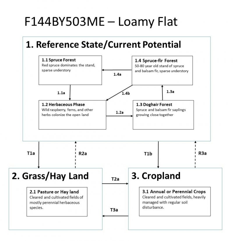
Click on box and path labels to scroll to the respective text.
