Natural Resources
Conservation Service
Ecological site F144BY304ME
Wet Clay Flat
Last updated: 5/13/2025
Accessed: 04/06/2026
General information
Provisional. A provisional ecological site description has undergone quality control and quality assurance review. It contains a working state and transition model and enough information to identify the ecological site.
MLRA notes
Major Land Resource Area (MLRA): 144B–New England and Eastern New York Upland, Northern Part
This major land resource area (MLRA) is in Maine (56 percent), New Hampshire (22 percent), Vermont (14 percent), Massachusetts (6 percent), Connecticut (1 percent), and New York (1 percent). It makes up about 22,728 square miles (58,864 square kilometers). The MLRA consists of a relatively young landscape shaped by the Laurentide Ice Sheet, which covered the region from 35,000 to 10,000 years ago. Rolling hills of dense basal till converge on ridges of shallow bedrock that were scoured by glacial ice. River valleys that were flooded by melting glacial water or seawater house large expanses of glacial outwash and stratified drift in inland areas and, to a lesser extent, glaciomarine and glaciolacustrine sediment deposits in coastal areas. Organic bogs, ablation till, and alluvial flood plains make up the remaining portions of the MLRA.
The soils in this region are dominantly Entisols, Spodosols, and Inceptisols. They commonly have a fragipan. The dominant suborders are Ochrepts, Orthods, Aquepts, Fluvents, and Saprists. The soils in the region dominantly have a frigid soil temperature regime with some cryic areas at higher elevation, a udic soil moisture regime, and mixed mineralogy. Most of the land is forested, and 98 percent is privately owned. Significant amounts of forest products are produced including lumber, pulpwood, Christmas trees, and maple syrup. Principal agricultural crops include forage and grains for dairy cattle, potatoes, apples, and blueberries. Wildlife habitat and recreation are important land uses. Stoniness, steep slopes, and poor drainage limit the use of many of the soils.
Classification relationships
NRCS:
Land Resource Region: R—Northeastern Forage and Forest Region
MLRA: 144B—New England and Eastern New York Upland, Northern PartMLRA resources
Major Land Resource Area (MLRA): 144B–New England and Eastern New York Upland, Northern Part
Ecological site concept
This ecological site is found on the frigid, poorly- and very poorly-drained, non-acidic, glacio-marine deposits in coastal and central interior marine terraces and river valleys. Northern white cedar inland or red and black spruce on the coast, are the dominant trees found on forested states and community phases of the ecological site. Other tree species that may commonly occur include red maple, balsam fir, black ash, and tamarack. On non-forested, permanently ponded, sites, alder, grasses, and sedges are common. This site is intermittently ponded and has a permanent high water table within 12 inches of the surface. The slow to very slow permeability in the sub-soil in relation to the relative linear landscape positions these soils are found on, results in the accumulation of 8 to 16 inches of organic matter at the surface and the high water table.
The reference state is considered a Palustrine forested wetland in the Cowardin Wetland Classification System (Cowardin et al. 1979) and a Mineral Soil Flat in the Hydrogeomorphic (HGM) Wetland Classification System (Brinson, M.M. 1993). Due to some micro-relief, pit and mound mostly, this site sometimes occurs as a major component of associations and complexes with drier mineral soils. A majority of the acreage is mapped as consociations. The reference plant community is dominantly hydrophytic vegetation.
Associated sites
| F144BY401ME |
Clay Flat The somewhat poorly- and poorly-drained Clay Flat site often occurs upslope of the poorly- and very poorly-drained Wet Clay Flat site |
|---|---|
| F144BY402ME |
Clay Hills The very poorly- and poorly-drained Clay Flat site may occur downslope of the moderately well- and well-drained Clay Hills site. |
Table 1. Dominant plant species
| Tree |
(1) Acer rubrum |
|---|---|
| Shrub |
Not specified |
| Herbaceous |
Not specified |
Physiographic features
This site is found on flat lake plains and terraces within coastal lowlands and river valleys. Slope is generally from 0 to 3 percent, and depth to a seasonal high water table is less than 6 inches. These soils are not subject to flooding, but may be ponded for long periods in low depressions, up to 4 inches deep. These sites are found from 0 to 1200 feet in elevation.
Table 2. Representative physiographic features
| Landforms |
(1)
Outwash plain
> Outwash delta
(2) Outwash plain > Depression (3) Outwash plain > Drainageway (4) Outwash plain > Terrace (5) River valley > Terrace (6) Upland > Till plain (7) Valley > Depression (8) Valley > Drainageway (9) Valley > Outwash plain (10) Bog (11) Ground moraine (12) Stream terrace (13) Swamp (14) Outwash terrace (15) Lake terrace |
|---|---|
| Runoff class | Very low to very high |
| Flooding frequency | None |
| Ponding duration | Long (7 to 30 days) |
| Ponding frequency | None to frequent |
| Elevation | 4,002 ft |
| Slope | 15% |
| Ponding depth | 4 in |
| Water table depth | 9 in |
| Aspect | Aspect is not a significant factor |
Climatic features
The climate is humid and temperate and is characterized by warm summers and cold winters. In general, precipitation is evenly distributed throughout the year. Near the coast, precipitation is slightly lower in summer. Throughout inland areas, precipitation is slightly higher during spring and fall seasons. Rainfall occurs during high-intensity, convective thunderstorms in summer. During winter, most of the precipitation occurs as moderate- intensity storms (northeasters) that produce large amounts of rain or snow. Heavy snowfalls commonly occur late in winter. Temperatures and the length of the freeze-free period increase from north to south and closer to the coast.
MLRA 144B has coverage across six states and may have substantial climate variability among locations: Maine (56 percent), New Hampshire (22 percent), Vermont (14 percent), Massachusetts (6 percent), Connecticut (1 percent), and New York (1 percent).
Table 3. Representative climatic features
| Frost-free period (characteristic range) | 102-130 days |
|---|---|
| Freeze-free period (characteristic range) | 136-156 days |
| Precipitation total (characteristic range) | 41-52 in |
| Frost-free period (actual range) | 79-137 days |
| Freeze-free period (actual range) | 119-170 days |
| Precipitation total (actual range) | 40-53 in |
| Frost-free period (average) | 116 days |
| Freeze-free period (average) | 146 days |
| Precipitation total (average) | 47 in |
Figure 1. Monthly precipitation range
Figure 2. Monthly minimum temperature range
Figure 3. Monthly maximum temperature range
Figure 4. Monthly average minimum and maximum temperature
Figure 5. Annual precipitation pattern
Figure 6. Annual average temperature pattern
Climate stations used
-
(1) BANGOR INTL AP [USW00014606], Bangor, ME
-
(2) ACADIA NP [USC00170100], Bar Harbor, ME
-
(3) JONESBORO [USC00174183], Addison, ME
-
(4) EAST HIRAM [USC00172238], Sebago, ME
-
(5) MADISON [USC00174927], Anson, ME
-
(6) BRUNSWICK NAS [USW00014611], Brunswick, ME
-
(7) AUGUSTA STATE AP [USW00014605], Augusta, ME
-
(8) SANFORD 2 NNW [USC00177479], Sanford, ME
-
(9) SAINT JOHNSBURY [USW00054742], Saint Johnsbury, VT
-
(10) WHITEFIELD MT WASHINGTON AP [USW00054728], Whitefield, NH
-
(11) BETHLEHEM 2 [USC00270706], Bethlehem, NH
-
(12) CHELSEA [USC00431360], Chelsea, VT
-
(13) MT SUNAPEE [USC00275629], Newbury, NH
-
(14) ASHBURNHAM NORTH [USC00190192], Ashburnham, MA
-
(15) BIRCH HILL DAM [USC00190666], Royalston, MA
-
(16) WORTHINGTON [USC00199972], Worthington, MA
-
(17) BORDEN BROOK RSVR [USC00190759], Granville, MA
-
(18) LANESBORO [USC00194075], Lanesboro, MA
-
(19) PITTSFIELD MUNI AP [USW00014763], Pittsfield, MA
-
(20) GRAFTON [USC00303360], Cropseyville, NY
-
(21) NORFOLK 2 SW [USC00065445], Norfolk, CT
Influencing water features
This site has no discernible surface-water inlet, and sources of water are from precipitation, overland flow, ground-water discharge from adjacent uplands, and shallow seepage from adjacent uplands (“interflow”). Water drains from these wetlands through intermittent or perennial streams, ground-water recharge, and (or) evapotranspiration. The water table is at the surface all times of the year and drainage is poor to very poor. This site is considered either semi-closed, riverine-tidal, or mineral soil flat wetland under the Hydrogeomorphic Wetland Classification System.
Wetland description
Cowardin System
Palustrine Forested Wetland
Soil features
The soils of this site are very deep, more than 60 inches to bedrock, and characterized by high percentages of silt and clay and low or non-existent volumes of rock fragments. Forested sites typically have a surface layer of 12 inches of mucky peat or muck, which is derived primarily from woody fragments. The thickness of the organic matter on some sites can range from 20 to 40 cm (8 to 16 inches) thick. Parent material is silty and clayey glacio-marine, or glacio-lacustrine deposits.
Though the soil is commonly free of rock fragments, a few samples contained up to 1 percent gravel. Stones are usually absent from the surface, but in some areas stone cover can be as high as 2 percent.
The soils of this site are olive gray, very deep silt loams, silty clay loams, or loams, with silty clay loam, silty clay or clay in the deeper horizons. Redoximorphic features are distinct or prominent throughout the mineral profile. Stone fragments and bedrock sometime occur in the profile at the Eg and Bg horizons or outcrop on the soil surface, but not to the extent that they impede the production of native vegetation. On unaltered sites, pit and mound topography maybe present, with drier or wetter soils present as minor components.
These soils have a non-acidic feature in that they have a pH that is 5.0 or more in 0.01M calcium chloride in at least some part of the control section (10 to 40 inches) of the soil profile.
The poor and very poor drainage classes, with intermittent ponding, and the silty and clayey soil textures have the most influence on plant community composition.
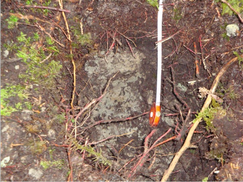
Figure 7.
Table 4. Representative soil features
| Parent material |
(1)
Drift
–
granite and gneiss
(2) Herbaceous organic material – granite and gneiss (3) Woody organic material – granite and gneiss (4) Organic material (5) Glaciofluvial deposits – granite and gneiss (6) Supraglacial meltout till – granite and gneiss (7) Outwash |
|---|---|
| Surface texture |
(1) Loam (2) Gravelly sand (3) Loamy coarse sand |
| Drainage class | Poorly drained to very poorly drained |
| Permeability class | Slow to moderately rapid |
| Soil depth | 60 in |
| Surface fragment cover <=3" | Not specified |
| Surface fragment cover >3" | 2% |
| Available water capacity (3-19in) |
Not specified |
| Soil reaction (1:1 water) (3.2-7.3in) |
Not specified |
| Subsurface fragment volume <=3" (0-51in) |
Not specified |
| Subsurface fragment volume >3" (0-6in) |
Not specified |
Ecological dynamics
[Caveat: The vegetation information contained in this section and is only provisional, based on concepts, and future projects support validation through field work. *] The vegetation groupings described in this section are based on the terrestrial ecological system classification and vegetation associations developed by NatureServe (Comer et al., 2003) and localized associations provided by the New York Natural Heritage Program (Edinger et al., 2014), Maine Natural Areas Program (Gawler and Cutko, 2010), New Hampshire Natural Heritage Program (Sperduto and Nichols, 2011), and Massachusetts Division of Fisheries and Wildlife (Swain, 2020).
The information contained in the State and Transition Model (STM) and the Ecological Site Description were developed using archeological and historical data, professional experience, and scientific studies. The information presented is representative of a very complex set of plant communities. Not all scenarios or plants are included. Key indicator plants, animals and ecological processes are described to inform land management decisions.
The historic reference plant community phase of this site is perceived to be an uneven-aged mixing of temperate deciduous and boreal species, called the “Acadian Forest”. This forest consisted of long-lived, shade-tolerant species with small gaps and relatively infrequent severe disturbances. Due to the multiple (8) biophysical regions involved and the history of land use and management, which involved over 95 percent of the MLRA land area, a least disturbed climax plant community phase will be considered the reference state for this ecological site description. The least disturbed climax state is a mixed conifer-hardwood forest.
Before European settlement, which occurred in the early 1600s, the plant community phase on this site consisted of an uneven-aged mixing of southern temperate deciduous and northern boreal species. This forest consisted of long-lived, shade-tolerant species with small gaps and relatively infrequent severe disturbances, from 0.6 to 1.0 percent per area per year. Dominant tree species were hemlock and spruce with a scattering of pines and cedar with some ash and oak according to early settlement survey records (Barton et al., 2012). In forested wetlands along the mid- and downeast coast, dominant tree species included spruce, birches, and alder with smaller amounts of pine, fir, maple, oak, beech, and hemlock, which is similar to present-day vegetation composition (Barton et al., 2012). The pre-settlement forest stands were generally between 104 to 203 years old in the oldest stands. Presettlement natural disturbances were usually small, single-tree mortality events caused by wind or insect damage, rather than stand replacing events. Stand replacing events include huge fires on average every 1,461 years and major wind storms, such as hurricanes, on average every 3,289 years. Extensive insect outbreaks, such as the spruce budworm infestation, were recorded as occurring every 60 to 70 years (Barton et al., 2012). During present day times, these natural disturbances still occur within these intervals of time.
The reference state (1.1), northern white cedar/three-seeded sedge (Thuja occidentalis/ Carex trisperma) is forested. Because of the constant harvesting of the forest and the composition of the data collected from representative sites, it was not possible to differentiate between a possible more mature and younger phase. The reference plant community phase has many of the same attributes, including species composition and structure, as the historic reference plant community phase. The site has a moderate to dense canopy cover, 75 to 95 percent, of a stratified mixture of even-aged conifer and northern hardwood tree species. Northern white cedar (Thuja occidentalis) is the major tree component with other codominant or intermediate species such as red spruce (Picea rubens), which occurs as a dominant tree on coastal sites. Red maple (Acer rubrum) and balsam fir (Abies balsamea) are usually in the suppressed understory. Some sites may contain black spruce (Picea mariana), and tamarack (Larix laricina). Some sites contain only red spruce and/or red maple depending on the geographic location within the MLRA and previous forest management.
The understory vegetation is very sparse due to the dense overstory cover except for very small open areas, less than a 0.1 of an acre, where a wide variety of forbs, ferns, and shrubs grow. The ground cover occurs within a typical pit and mound microtopography. Under the dense conifer overstory, only small scattered shade-tolerant and moisture-loving plants grow. Many species of feather-moss grow over the ground, on dead wood, and the bottoms of trees. Tall shrubs are virtually non-existent in this dense, shady, understory. In the small open areas, taller shrubs, such as common winterberry (Ilex verticillata) and speckled alder (Alnus incana) are present along with small shrubs such as dwarf red raspberry (Rubus pubescens) and wild sarsaparilla (Aralia nudicaulis), which occurs on the mounds. Seedlings and saplings of red maple and balsam fir are typically found in small patches. Clumps of cinnamon fern (Osmunda cinnamomea) as well as sensitive fern (Onoclea sensibilis) are also commonly found. Forbs usually found include starflower (Trientalis borealis) and blue-bead lily (Clintonia borealis) on the mounds. Very few grass or grass-like plant species were found on this site. There were more sedges than grasses and both appeared in small clumps scattered sparsely throughout. Threeseeded sedge (Carex trisperma) was common to abundant. Leafy liverworts were prevalent in the pits and feather mosses were common at most sample sites on the mounds. On one site skunk cabbage (Symplocarpus foetidus) was abundant in the pools of water.
Natural disturbances include ice and wind storms, and insect infestations that cause small gaps in the canopy. These small open areas in the forest provide an abundance of small herbs, grasses, sedges, and shrubs as well as tree regeneration for a brief period of time. Many species of medium and small sized mammals, birds, and insects can have significant influence on the plant communities in terms of pollination, herbivory, seed dispersal, and creation of local disturbance patches, all of which contribute to plant species diversity.
Human disturbances are primarily restricted to timber harvesting due to the very poor drainage. Harvesting of this reference state has been continuous over the years since European settlement, with all harvesting occurring in the winter months due to the very poorly drained nature of the soil. spruce and pine were the desirable species to harvest, mainly for timber up until about 10 years ago, although northern white cedar was used for house roofs and siding because of its resistance to decay. Presently all types of trees, including standing dead trees, are harvested for their best use depending on their size and grade. Best use includes timber, pulp, cordwood, firewood, and biomass. The ponded state (2.1) is a result of natural disturbances from beaver activity, which causes frequent ponding for long durations. This is considered a state and not a plant community phase of the reference state because the long duration would realistically be considered permanent. The nature of beaver and the particular laws regarding their control in Maine make the ponded state permanent. Beaver control has been on-going for multiple decades, but control has never been achieved. The hydrology is permanently altered to favor open areas of shrubs such as alder, grasses, and grass-like plants, such as tussock sedge. Yellow pond-lily (Nuphar lutea spp advena) was found at one sample site in a permanently ponded area.
A typical harvested state (3.1) consists of young red maple with a few gray, birch, balsam fir and sometimes black ash. Any larger trees remaining are of poor grade and some younger looking trees are actually older suppressed trees that may not respond to release. This state is usually harvested in the winter when the soil is frozen and is typically allowed to regenerate naturally back to the reference state over a long time period or may become a red maple swamp.
Reference, ponded, and harvested states may become infested with invasive plants such as purple loosestrife and Japanese knotweed. The flooded state (2.1) is particularly vulnerable to invasion from these two species. Brush management multiple times and planting of desirable native plants would be required to restore to a reference state.
A State and Transition Model for the Marine Terrace Depression Ecological Site (F144BY002ME) follows this narrative. Thorough descriptions of each state, transition, plant community, and pathway follow the model. Experts base this model on available experimental research, field observations, professional consensus, and interpretations. It is likely to change as knowledge increases.
Plant communities will differ across the MLRA because of the naturally occurring variability in weather, soils, and aspect. The Reference Plant Community is not necessarily the management goal. The biological processes on this site are complex. Therefore, representative values are presented in a land management context. The species lists are representative and are not botanical descriptions of all species occurring, or potentially occurring, on this site. They are not intended to cover every situation or the full range of conditions, species, and responses for the site.
The following diagram suggests some pathways that the vegetation on this site might take. There may be other states not shown on the diagram. This information is intended to show what might happen in a given set of circumstances. It does not mean that this would happen the same way in every instance. Local professional guidance should always be sought before pursuing a treatment scenario.
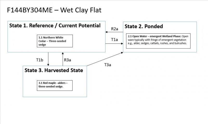
State and transition model
More interactive model formats are also available.
View Interactive Models
More interactive model formats are also available.
View Interactive Models
Click on state and transition labels to scroll to the respective text
State 1 submodel, plant communities
State 2 submodel, plant communities
State 3 submodel, plant communities
State 1
Reference State/Current Potential
The forested plant community phase (1.1) has a medium to dense canopy cover, averaging 85 percent and ranges from 75 to 95 percent. It consists of a stratified mixture of conifer and northern hardwood tree species. Northern white cedar (Thuja occidentalis) forms a canopy over other codominant or intermediate species such as red spruce (Picea rubens), except along the coast, red maple (Acer rubrum), gray birch (Betula populifolia), black ash (Fraxinus nigra), balsam fir (Abies balsamea), black spruce (Picea mariana), and tamarack (Larix laricina). Some sites have more red spruce or red maple depending on their previous forest management or location. The understory may be sparse due to a dense conifer overstory cover except for small open areas, less than a 0.1 of an acre, where a wide variety of forbs, ferns, and shrubs grow. Under the dense conifer overstory, only small scattered shade-tolerant and moisture-loving plants grow. Plants include balsam fir regeneration, a few sedges, and many species of feather-mosses and leafy liverworts. The moss grows over the mounds, on downed dead wood, and the bottoms of trees throughout this site. Due to the dense, shady, understory tall shrubs are almost non-existent. In the small open areas, taller shrubs, such as speckled alder (Alnus incana), are present along with wild sarsaparilla (Aralia nudicaulis) and dwarf red raspberry (Rubus pubescens). Clumps of cinnamon fern (Osmunda cinnamomea) and small patches of sensitive fern (Onoclea sensibilis) are also common on the mounds. Small forbs usually found on hummocks include maystar (Trientalis borealis), blue-bead lily (Clintonia borealis), and bunchberry (Cornus canadensis). Eastern poison-ivy may also be present on some sites and should be avoided because it can cause severe dermatitis. On one sample site, skunk cabbage (Symplocarpus foetidus) was abundant in the pools of water. Very few grass or grass-like plant species were found on this site. There were more sedges than grasses and both appeared in small clumps on mounds scattered throughout. Typical sedges include three-seeded sedge (Carex trisperma).
Community 1.1
Northern White Cedar - Three-seeded sedge
This is the reference community for the site. The description is based on historical descriptions, site index data, professional consensus of experienced ecologists, and analysis of field work. In reference condition this site is perceived to be a mixed conifer-hardwood forest. Due to the multiple (8) biophysical regions involved and the history of land use and management, a least disturbed climax state will be considered the reference state for this ESD. The least disturbed climax state is a mixed conifer-hardwood forest that has been harvested multiple times over the years. The reference plant community phase has a dominant tree community of northern red cedar or on some sites red spruce and/or red maple. Northern red cedar and red spruce are slower growing than red maple and where it has been heavily harvested, it has been shaded out by red maple. The intermediate canopy consists of red maple, gray birch, black ash, balsam fir, red and black spruce, and tamarack. Typical conifers are a mix of northern red cedar, spruce, tamarack and fir. Typical hardwoods are red maple, black ash, and a few birch species. Overstory canopy cover ranges from 75 to 95 percent. Because of the moderate to dense overstory, the understory consists of a few shade tolerant small shrubs, ferns and forbs such as three-seeded sedge. The ground surface is made up of pits and mounds with large patches of feather-mosses and leafy hornworts due to the moderate to dense shade and high moisture levels. There is a diverse and abundant amount of downed woody debris present. Hard and soft tree snags are typically present in abundance. The plant community can be restored from a harvest using appropriate brush management combined with either native regeneration, or if invasive species are a problem, a tree/shrub planting. It will be very difficult to restore a ponded state to a reference state because of the pervasive nature of beaver, but with removal of beaver dams and proper beaver control, sites may naturally return to the reference plant community over a long period of time.
State 2
Ponded State
The ponded state is a result of beaver activity. This state is frequently ponded for long durations. The description is based on historical descriptions, site index data, professional consensus of experienced ecologists, and analysis of field work. This state is perceived to be a mixture of shrubs, typically speckled alder (Alnus incana) and graminoids, such as tussock (upright) sedge (Carex stricta) with few if any mature trees because they have been drowned out or eaten by the beavers.
Community 2.1
2.1 Open Water – emergent Wetland Phase
This is the frequently ponded for long duration plant community phase. The description is based on historical descriptions, site index data, professional consensus of experienced ecologists, and analysis of field work. This phase is perceived to be a mixture of shrubs and graminoids with few if any mature trees. All the plant species are hydrophytic.
State 3
Harvested state
The harvested state is quite common in Maine. Most harvesting is by an individual tree or group selection method in this MLRA and on this site. The reference forest has been harvested for the most desirable species, northern red cedar and spruce. The remaining forest stand consists of young red maple and gray birch with a few balsam fir, tamarack, and black ash. This state is most like the reference state in plant composition particularly in the understory if only small openings are created like for an individual tree selection harvest. Group selection harvests may make larger openings temporarily that will allow other species to grow for very short periods of time. If northern red cedar and red spruce are harvested in large quantities, the harvested state will become dominated by red maple and other faster growing species.
Community 3.1
Red Maple/Alder/Three-seeded sedge
The harvested state is the most common plant community phase of this ecological site in Maine. Most harvesting is by an individual tree or group selection method in this MLRA and on this site. The reference forest has been harvested for the most desirable species, northern red cedar and red spruce. The remaining forest stand consists of young red maple as the dominant species, or co-dominant with tamarack or black spruce. The lower overstory consists of red maple, balsam fir, gray birch, black ash, tamarack, black spruce, and northern white cedar. Eastern white pine may be present on mounds at the edge of the drier sites. This state is most like the reference state in plant composition particularly in the understory if only small openings are created like for an individual tree selection harvest. Group selection harvests may make larger openings temporarily that will allow other species to grow for very short periods of time. If northern red cedar and red spruce are harvested in large quantities, the overstory will become dominated by red maple and other faster growing species. The understory will contain more shrubs and forbs. Feather-mosses and leafy liverworts are still present in abundance on the pit and mound microrelief. Downed woody debris is still quite high in this plant community phase. Hard snag trees are more abundant than soft snag trees.
Transition T
State 1 to 2
Transition T1b
State 1 to 3
The reference state transitions to a harvested state by the removal of some or all desirable woody vegetation. Hydrology may be moderately to severely altered by the addition of woody debris or gravel in forest access trails and roads in narrow linear locations throughout the site if done at the wrong time of year or at inappropriate times, such as during or after heavy rainfalls.
Restoration pathway R2a
State 2 to 1
The ponded state may transition to a reference state by the elimination of beavers and their dams, and allowing the return after many years of normal hydrology that will favor trees. Tree and shrub planting might also be used to speed up the process.
Restoration pathway R3a
State 3 to 1
The harvested state may be restored to the reference state by natural regeneration over a period of time or the planting of desirable vegetation which may shorten the period of time to full canopy status. Invasive species establishment and wildlife damage to plants must be controlled in order to fully restore the site.
Restoration pathway T3a
State 3 to 2
The harvested state may transition to a flooded state from the effects of beavers on the hydrology of a site. Beavers can cause a long term elevation of ponded water and the killing of nearby trees for food. This will eliminate trees and favor the growth of shrubs, forbs, and grasses.
Additional community tables
Interpretations
Supporting information
Inventory data references
Future work is needed, as described in a future project plan, to validate the information presented in this provisional ecological site description. Future work includes field sampling, data collection and analysis by qualified vegetation ecologists and soil scientists. As warranted, annual reviews of the project plan can be conducted by the Ecological Site Technical Team. A final field review, peer review, quality control, and quality assurance reviews of the ESD are necessary to approve a final document.
Other references
Comer, P., D. Faber-Langendoen, R. Evans, S. Grawler, C. Josse, G. Kittel, S. Menard, M. Pyne, M. Reid, K. Schultz, K. Snow, and J. Teague. 2003. Ecological Systems of the United States: A Working Classification of U.S. Terrestrial Systems. NatureServe, Arlington, Virginia
Edinger, G. J., D. J. Evans, S. Gebauer, T. G. Howard, D. M. Hunt, and A. M. Olivero (editors). 2014. Ecological Communities of New York State. Second Edition. A revised and expanded edition of Carol Reschke’s Ecological Communities of New York State. New York Natural Heritage Program, New York State Department of Environmental Conservation, Albany, NY.
Gawler, S. and A. Cutko. 2010. Natural Landscapes of Maine: A Guide to Natural Communities and Ecosystems. Maine Natural Areas Program, Maine Department of Conservation, Augusta, Maine.
NatureServe. 2021. NatureServe Explorer: An online encyclopedia of life [web application]. NatureServe, Arlington, Virginia. https://explorer.natureserve.org/. (accessed 10 July. 2021).
Soil Survey Staff, Natural Resources Conservation Service, United States Department of Agriculture. 2006. Land Resource Regions and Major Land Resource Areas of the United States, the Caribbean, and the Pacific Basin. Agricultural Handbook 296
Soil Survey Staff, Natural Resources Conservation Service, United States Department of Agriculture. Official Soil Series Descriptions. Available online. (accessed 11 Aug. 2021).
Soil Survey Staff, Natural Resources Conservation Service, United States Department of Agriculture. Soil Climate Research Station Data. Available online. (accessed 23 June. 2021).
Soil Survey Staff, Natural Resources Conservation Service, United States Department of Agriculture. Soil Survey Geographic (SSURGO) Database for [MLRA 141, Maine]. Available online. (accessed 14 Oct. 2021).
Sperduto, D.D. and William F. Nichols. 2011. Natural Communities of New Hampshire. 2nd Ed. NH Natural Heritage Bureau, Concord, NH. Pub. UNH Cooperative Extension, Durham, NH.
Swain, P. C. 2020. Classification of the Natural Communities of Massachusetts. Massachusetts Division of Fisheries and Wildlife, Westborough, MA
USNVC [United States National Vegetation Classification]. 2017. United States National Vegetation Classification Database V2.01. Federal Geographic Data Committee, Vegetation Subcommittee, Washington DC. Available The U.S. National Vegetation Classification (usnvc.org) (accessed 2 July. 2021).
Contributors
Christopher Mann
Approval
Greg Schmidt, 5/13/2025
Acknowledgments
Nels Barrett and Nick Butler provided considerable review of this ecological site concept.
Rangeland health reference sheet
Interpreting Indicators of Rangeland Health is a qualitative assessment protocol used to determine ecosystem condition based on benchmark characteristics described in the Reference Sheet. A suite of 17 (or more) indicators are typically considered in an assessment. The ecological site(s) representative of an assessment location must be known prior to applying the protocol and must be verified based on soils and climate. Current plant community cannot be used to identify the ecological site.
| Author(s)/participant(s) | |
|---|---|
| Contact for lead author | |
| Date | 06/29/2020 |
| Approved by | Greg Schmidt |
| Approval date | |
| Composition (Indicators 10 and 12) based on | Annual Production |
Indicators
-
Number and extent of rills:
-
Presence of water flow patterns:
-
Number and height of erosional pedestals or terracettes:
-
Bare ground from Ecological Site Description or other studies (rock, litter, lichen, moss, plant canopy are not bare ground):
-
Number of gullies and erosion associated with gullies:
-
Extent of wind scoured, blowouts and/or depositional areas:
-
Amount of litter movement (describe size and distance expected to travel):
-
Soil surface (top few mm) resistance to erosion (stability values are averages - most sites will show a range of values):
-
Soil surface structure and SOM content (include type of structure and A-horizon color and thickness):
-
Effect of community phase composition (relative proportion of different functional groups) and spatial distribution on infiltration and runoff:
-
Presence and thickness of compaction layer (usually none; describe soil profile features which may be mistaken for compaction on this site):
-
Functional/Structural Groups (list in order of descending dominance by above-ground annual-production or live foliar cover using symbols: >>, >, = to indicate much greater than, greater than, and equal to):
Dominant:
Sub-dominant:
Other:
Additional:
-
Amount of plant mortality and decadence (include which functional groups are expected to show mortality or decadence):
-
Average percent litter cover (%) and depth ( in):
-
Expected annual annual-production (this is TOTAL above-ground annual-production, not just forage annual-production):
-
Potential invasive (including noxious) species (native and non-native). List species which BOTH characterize degraded states and have the potential to become a dominant or co-dominant species on the ecological site if their future establishment and growth is not actively controlled by management interventions. Species that become dominant for only one to several years (e.g., short-term response to drought or wildfire) are not invasive plants. Note that unlike other indicators, we are describing what is NOT expected in the reference state for the ecological site:
-
Perennial plant reproductive capability:
Print Options
Sections
Font
Other
The Ecosystem Dynamics Interpretive Tool is an information system framework developed by the USDA-ARS Jornada Experimental Range, USDA Natural Resources Conservation Service, and New Mexico State University.
Click on box and path labels to scroll to the respective text.