Natural Resources
Conservation Service
Ecological site F146XY011ME
Floodplain
Last updated: 5/20/2025
Accessed: 04/10/2026
General information
Provisional. A provisional ecological site description has undergone quality control and quality assurance review. It contains a working state and transition model and enough information to identify the ecological site.
MLRA notes
Major Land Resource Area (MLRA): 146X–Aroostook Area
This area is entirely in Maine and makes up about 1,275 square miles (3,305 square kilometers). Presque Isle is the largest city in the area. Interstate 95 ends in the town of
Houlton, at the border with New Brunswick, Canada. Aroostook State Park, Fort Kent Historic Site, and Loring Commerce Center are in this area. The Big Rock ski area is in the middle of this MLRA and is on the highest point, which is Mars Hill Mountain.
Ecological site concept
The floodplain ecological site includes floodplains, banks, terraces, sand and cobble bars, and all other land surfaces associated with major river and stream deposits. Flood frequency and intensity are the primary drivers of plant community distribution within this complex of soils and vegetation. Where seasonal flooding deposits or drought expose sands and cobbles along the river’s edge, herbs, sedges, and grasses predominate.
Silt loams predominate, with occasional lenses of coarser sands, gravels, and cobbles deposited during high-energy flood events. Oxbows and backwater sloughs diversify the soils even further, resulting in a broad range of textures and drainage classes. Where soils are well or moderately well-drained, this site is considered prime farmland and is mostly under cultivation.
Associated sites
| F146XY021ME |
Marsh The marsh ecological site may occur adjacent to or within floodplains due to hydrological alteration (natural/anthropogenic) of floodplain sites. |
|---|
Similar sites
| F143XY110ME |
Broad Floodplain Riparian Complex Similar to other floodplains in adjacent MLRAs. |
|---|
Table 1. Dominant plant species
| Tree |
(1) Acer saccharinum |
|---|---|
| Shrub |
(1) Alnus incana |
| Herbaceous |
(1) Calamagrostis canadensis |
Physiographic features
This site occurs on the banks, floodplains, terraces and other surfaces associated with large rivers and streams. Slopes are gentle and elevations range from near sea level up to 1750 feet.
This site represents a riverine complex of various topographic features which are deposited and maintained by large amounts of flowing water. Nearest the channel, stream banks can be steep and stabilized, or slope gently into the water, especially where sands, gravels, or cobbles are exposed. Natural levies sometimes form along the banks, which often affect the species composition of the floodplain. The active floodplain is a flat area where floodwaters dissipate energy as they overflow their banks, depositing a thin layer of sediment along the way. At the banks and active floodplains, the water table is most often within 36 inches of the soil surface. Further away from the channel, floodplains often border elevated steps and stream terraces, which flood less frequently than the active floodplain and have a deeper water table. Each of these fluvial surfaces may support a distinct plant community.
Table 2. Representative physiographic features
| Landforms |
(1)
Flood plain
(2) Stream terrace (3) Flood-plain step |
|---|---|
| Runoff class | Negligible to low |
| Flooding duration | Brief (2 to 7 days) to long (7 to 30 days) |
| Flooding frequency | Rare to frequent |
| Ponding frequency | None |
| Elevation | 10 – 1,000 ft |
| Slope | 5% |
| Water table depth | 72 in |
| Aspect | Aspect is not a significant factor |
Climatic features
The climate of this site is characterized by cold, snowy winters, and cool summers. Precipitation is nearly equally distributed throughout the year, with slightly more moisture falling in June-October. During winter months, and sometimes fall and spring, cold winds from the north bring severe weather events. The effects of a relatively short growing season are somewhat mitigated by long summer days associated with the high latitudes of the region. Occasionally high winds, heavy snow load, microbursts, or freezing rain events damage vegetation over small portions of the landscape.
Table 3. Representative climatic features
| Frost-free period (characteristic range) | 80-94 days |
|---|---|
| Freeze-free period (characteristic range) | 126-134 days |
| Precipitation total (characteristic range) | 37-42 in |
| Frost-free period (actual range) | 61-107 days |
| Freeze-free period (actual range) | 103-141 days |
| Precipitation total (actual range) | 36-42 in |
| Frost-free period (average) | 85 days |
| Freeze-free period (average) | 127 days |
| Precipitation total (average) | 39 in |
Figure 1. Monthly precipitation range
Figure 2. Monthly minimum temperature range
Figure 3. Monthly maximum temperature range
Figure 4. Monthly average minimum and maximum temperature
Figure 5. Annual precipitation pattern
Figure 6. Annual average temperature pattern
Climate stations used
-
(1) ALLAGASH [USC00170200], Saint Francis, ME
-
(2) BRIDGEWATER [USC00170833], Bridgewater, ME
-
(3) FT KENT [USC00172878], Fort Kent, ME
-
(4) HOULTON 5N [USC00173944], Houlton, ME
-
(5) PRESQUE ISLE [USC00176937], Presque Isle, ME
-
(6) HOULTON INTL AP [USW00014609], Houlton, ME
-
(7) CARIBOU MUNI AP [USW00014607], Caribou, ME
Influencing water features
The effects of hydrology on this ecological site require further study. In general, this site occurs along the banks of large and medium sized perennial rivers that historically flooded regularly, as evidenced by the existence of layered floodplain deposits. However, the regulation of flow by dams, and the armoring of banks in some places, has reduced the impact of flooding on these sites.
Soil features
The soils of this site are deep but otherwise highly variable, as is common in alluvial settings. The dominant soil textures are silt loams, with occasional sand and gravel lenses. Typically there are very few rock fragments on the soil surface and throughout the profile, but along stream banks or older deposits there may be pockets with significant amounts of rounded rock. This site is mostly poorly and somewhat poorly drained soils, with some higher areas that are moderately well to well drained. The soil temperature regime is frigid, and the soil moisture regime is aquic or udic.
Additional study is required to identify whether consistent patterns exist between fluvial surfaces and soils and plants that occur on them.
Table 4. Representative soil features
| Parent material |
(1)
Alluvium
–
slate
|
|---|---|
| Surface texture |
(1) Silt loam (2) Mucky silt loam (3) Very gravelly silt loam |
| Family particle size |
(1) Loamy |
| Drainage class | Very poorly drained to well drained |
| Permeability class | Moderately slow |
| Soil depth | 60 in |
| Surface fragment cover <=3" | 4% |
| Surface fragment cover >3" | 5% |
| Available water capacity (0-40in) |
6.7 – 15.7 in |
| Calcium carbonate equivalent (0-40in) |
Not specified |
| Electrical conductivity (0-40in) |
Not specified |
| Sodium adsorption ratio (0-40in) |
Not specified |
| Soil reaction (1:1 water) (0-40in) |
3.6 – 6.5 |
| Subsurface fragment volume <=3" (Depth not specified) |
50% |
| Subsurface fragment volume >3" (Depth not specified) |
10% |
Ecological dynamics
[Caveat: The vegetation information contained in this section and is only provisional, based on concepts, and future projects support validation through field work. *] The vegetation groupings described in this section are based on the terrestrial ecological system classification and vegetation associations developed by NatureServe, 2018 and localized associations provided by the Maine Natural Areas Program (Gawler and Cutko, 2010).
The floodplains site is a riparian complex, consisting of several distinct soils and plant communities that predictably occur on fluvial surfaces found along major rivers. Stream banks, point bars, and other fluvial surfaces closest to the water are the most dynamic component in the complex as erosion and deposition regularly re-arranges the location and specific soil properties of these surfaces. The proportion of each component in the riparian ecological site complex varies with disturbance.
Frequently disturbed stream banks are dominated by herbaceous and lesser disturbed floodplains and natural levees support more woody vegetation. Trees tend to dominate on floodplains where disturbances are less frequent, and soils are more stable while upper terraces receive the least amount of flooding and disturbance tend to support more upland species.
State and transition model
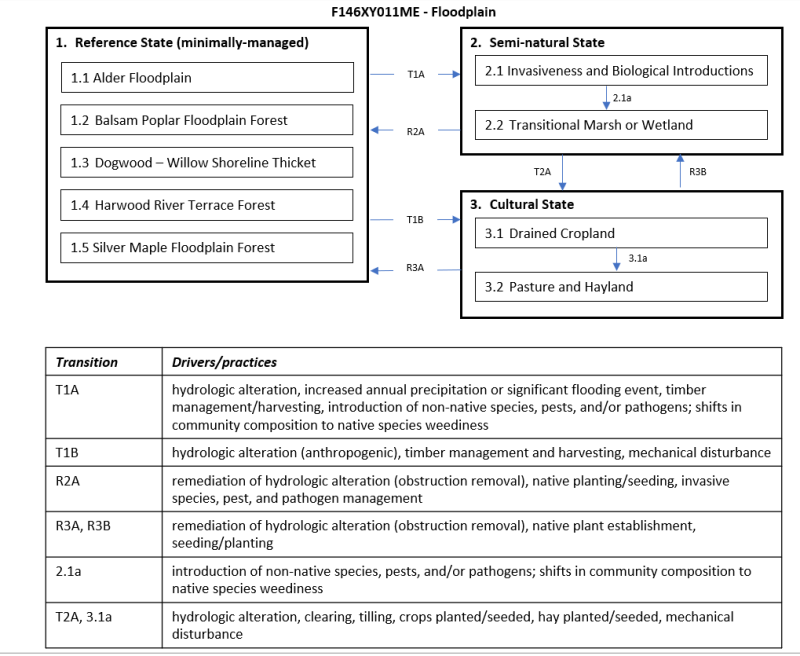
More interactive model formats are also available.
View Interactive Models
More interactive model formats are also available.
View Interactive Models
Click on state and transition labels to scroll to the respective text
State 2 submodel, plant communities
State 3 submodel, plant communities
State 1
Reference State (minimally-managed)
The floodplains site is a riparian complex, consisting of several distinct soils and plant communities that predictably occur on fluvial surfaces found along major rivers. Stream banks, point bars, and other fluvial surfaces closest to the water are the most dynamic component in the complex as erosion and deposition regularly re-arranges the location and specific soil properties of these surfaces. The proportion of each component in the riparian ecological site complex varies with disturbance.
Characteristics and indicators. Frequently-disturbed stream banks are dominated by herbaceous and lesser disturbed floodplains and natural levees support more woody vegetation. Trees tend to dominate on floodplains where disturbances are less frequent and soils are more stable while upper terraces receive the least amount of flooding and disturbance tend to support more upland species.
Resilience management. The construction of dams and bank armoring structures tend to reduce the frequency of disturbance on floodplains, resulting in a greater proportion of forested communities following the construction of these structures. High intensity floods are likely to occur infrequently in these systems, however, their effects are not currently understood.
Dominant plant species
-
balsam fir (Abies balsamea), tree
-
balsam poplar (Populus balsamifera), tree
-
black ash (Fraxinus nigra), tree
-
American elm (Ulmus americana), tree
-
speckled alder (Alnus incana ssp. rugosa), tree
-
redosier dogwood (Cornus sericea), tree
-
bluejoint (Calamagrostis canadensis), grass
-
western blue virginsbower (Clematis occidentalis), other herbaceous
-
royal fern (Osmunda regalis), other herbaceous
-
sensitive fern (Onoclea sensibilis), other herbaceous
-
ostrich fern (Matteuccia struthiopteris), other herbaceous
-
zigzag goldenrod (Solidago flexicaulis), other herbaceous
-
parasol whitetop (Doellingeria umbellata), other herbaceous
-
king of the meadow (Thalictrum pubescens), other herbaceous
-
common boneset (Eupatorium perfoliatum), other herbaceous
Dominant resource concerns
-
Ephemeral gully erosion
-
Classic gully erosion
-
Bank erosion from streams, shorelines, or water conveyance channels
-
Ponding and flooding
-
Seasonal high water table
-
Nutrients transported to surface water
-
Pesticides transported to surface water
-
Pathogens and chemicals from manure, biosolids, or compost applications transported to surface water
-
Sediment transported to surface water
-
Plant productivity and health
-
Plant structure and composition
-
Plant pest pressure
-
Terrestrial habitat for wildlife and invertebrates
-
Aquatic habitat for fish and other organisms
Community 1.1
Alder Floodplain
These are shrub-dominated floodplains characterized by speckled alder and an assemblage of grasses and herbs indicative of alluvial conditions. Heath shrubs and peat are sparse or absent. These sites occur along medium to large moderate to high energy riverbanks that are seasonally flooded and subject to ice scour, typically on mineral soil. (Gawler and Cutko, 2010)
Resilience management. Maine Natural Areas Program State Rank: S4 Apparently Secure – At fairly low risk of extinction or elimination due to an extensive range and/or many populations or occurrences, but with possible cause for some concern as a result of local recent declines, threats, or other factors. The rivershore habitat of this natural community suggests that direct threats from development are relatively low though excessive watershed development would likely increase the volume and intensity of runoff and potentially alter riverine structure and community composition. Additionally, hydrologic alteration (i.e., impoundments) would compromise the disturbance regime, but new dams are unlikely on medium and large rivers. (Gawler and Cutko, 2010)
Forest overstory. Alders dominate and comprise >30% cover
Dominant plant species
-
speckled alder (Alnus incana ssp. rugosa), tree
-
red maple (Acer rubrum), tree
-
redosier dogwood (Cornus sericea), shrub
-
southern arrowwood (Viburnum dentatum), shrub
-
queen of the meadow (Filipendula ulmaria), shrub
-
bluejoint (Calamagrostis canadensis), grass
-
common boneset (Eupatorium perfoliatum), other herbaceous
-
common ladyfern (Athyrium filix-femina), other herbaceous
-
royal fern (Osmunda regalis), other herbaceous
-
bristly dewberry (Rubus hispidus), other herbaceous
-
king of the meadow (Thalictrum pubescens), other herbaceous
-
devil's darning needles (Clematis virginiana), other herbaceous
-
parasol whitetop (Doellingeria umbellata), other herbaceous
-
ostrich fern (Matteuccia struthiopteris), other herbaceous
-
sensitive fern (Onoclea sensibilis), other herbaceous
-
(Boehmeria celebica), other herbaceous
Dominant resource concerns
-
Bank erosion from streams, shorelines, or water conveyance channels
-
Ponding and flooding
-
Seasonal high water table
-
Plant productivity and health
-
Plant structure and composition
-
Terrestrial habitat for wildlife and invertebrates
-
Aquatic habitat for fish and other organisms
Community 1.2
Balsam Poplar Floodplain Forest
These partly open to closed canopy forests are dominated by balsam poplar and occur along medium-sized rivers. This association includes a wide range of early seral, wetland, and floodplain species. Sites occur on seasonally inundated floodplains or slightly elevated terraces flanking low gradient rivers in central and northern Maine. Sites are often embedded within a matrix of open oxbows and shrub thickets. These forests have lower frequency and duration of flooding than Silver Maple Floodplain Forests. Soils are alluvial fine sand or silt, usually with good drainage capacity. (Gawler and Cutko, 2010)
Resilience management. Maine Natural Areas Program State Rank: S2 Imperiled in Maine because of rarity (6-20 occurrences or few remaining individuals or acres) or because of other factors making it vulnerable to further decline. The few known examples of this type have been influenced by past disturbances, including harvesting, beaver damage, and potentially fire. As a result, long term successional trends are not clear. Exotic plant species, which may displace those native to our area, may be easily transported to sites by river waters and represent a threat to the integrity of these forests. The biggest threat may be hydrologic alteration. All known sites in Maine are on private land. (Gawler and Cutko, 2010)
Dominant plant species
-
American elm (Ulmus americana), tree
-
balsam fir (Abies balsamea), tree
-
balsam poplar (Populus balsamifera), tree
-
black ash (Fraxinus nigra), tree
-
dwarf raspberry (Rubus arcticus ssp. acaulis), shrub
-
bluejoint (Calamagrostis canadensis), grass
-
royal fern (Osmunda regalis), other herbaceous
-
ostrich fern (Matteuccia struthiopteris), other herbaceous
-
sensitive fern (Onoclea sensibilis), other herbaceous
-
Canadian woodnettle (Laportea canadensis), other herbaceous
Dominant resource concerns
-
Bank erosion from streams, shorelines, or water conveyance channels
-
Ponding and flooding
-
Seasonal high water table
-
Plant productivity and health
-
Plant structure and composition
-
Plant pest pressure
-
Wildfire hazard from biomass accumulation
-
Terrestrial habitat for wildlife and invertebrates
-
Aquatic habitat for fish and other organisms
Community 1.3
Dogwood Willow Shoreline Thicket
Sites occupy shores of larger rivers, below the annual high-water line, in areas somewhat protected from the extremes of ice scour and flooding. Riverbanks are moderate to steep, not flat; the silty to sandy soils are not constantly saturated. Successional dynamics have not been studied, but at least some sites appear to persist through disturbance. Dense riparian shrub vegetation (>80% cover) is dominated by a mixture of red osier dogwood and shrub willows. Alders may be present but are not dominant. A band of bush-honeysuckle often forms at the upslope edge where the shrub vegetation abuts upland forest. Herb richness may be high in openings among the shrubs and may include some calciphiles as well as more widespread species. Bryoids are minor and consist of bryophytes rather than lichens. More study of alluvial shrub communities is needed. (Gawler and Cutko, 2010)
Resilience management. Maine Natural Areas Program State Rank: S2 Imperiled – At high risk of extinction or elimination due to restricted range, few populations or occurrences, steep declines, severe threats, or other factors. Natural river hydrology, with annual fluctuations, is important in the maintenance of this community. These areas receive little direct use but may be affected by adjacent land use, so an intact buffer of adjoining upland would be helpful. No studies of the dynamics of this community have been done. (Gawler and Cutko, 2010)
Dominant plant species
-
northern bush honeysuckle (Diervilla lonicera), shrub
-
redosier dogwood (Cornus sericea), shrub
-
Missouri River willow (Salix eriocephala), shrub
-
roundleaf dogwood (Cornus rugosa), shrub
-
shining willow (Salix lucida), shrub
-
speckled alder (Alnus incana ssp. rugosa), shrub
-
bluejoint (Calamagrostis canadensis), grass
-
fringed brome (Bromus ciliatus), grass
-
parasol whitetop (Doellingeria umbellata), other herbaceous
-
fringed loosestrife (Lysimachia ciliata), other herbaceous
-
spotted joe pye weed (Eutrochium maculatum), other herbaceous
Dominant resource concerns
-
Organic matter depletion
-
Aggregate instability
-
Ponding and flooding
-
Seasonal high water table
-
Surface water depletion
-
Ground water depletion
-
Plant productivity and health
-
Plant structure and composition
-
Plant pest pressure
-
Terrestrial habitat for wildlife and invertebrates
-
Aquatic habitat for fish and other organisms
Community 1.4
Hardwood River Terrace Forest
These ecological sites occur on slightly elevated terraces flanking low-gradient rivers at elevations typically <1,000’. Flooding is occasional, sometimes less frequent than annually. Most known examples are along medium to larger rivers. Soils are fine sand or silt, usually with good drainage capacity and relatively high nutrient levels; pH is 5.0-6.2. The overstory provides almost complete canopy cover, while understory is open and shrubs are sparse. The lush carpet of herbs changes from spring ephemerals to variable cover of mixed graminoids and forbs in summer. Bryoid cover is minor. (Gawler and Cutko, 2010)
Resilience management. Maine Natural Areas Program State Rank: S3 Vulnerable – At moderate risk of extinction or elimination due to a fairly restricted range, relatively few populations or occurrences, recent and widespread declines, threats, or other factors. Virtually all of these forests have been harvested, and many have been converted to agriculture. Non-native plant species such as Japanese knotweed and Asiatic bittersweet, which may displace those native to our area, represent a threat to the integrity of these forests and have degraded at least some Maine examples.(Gawler and Cutko, 2010)
Dominant plant species
-
American basswood (Tilia americana), tree
-
black cherry (Prunus serotina), tree
-
green ash (Fraxinus pennsylvanica), tree
-
northern red oak (Quercus rubra), tree
-
sugar maple (Acer saccharum), tree
-
yellow birch (Betula alleghaniensis), tree
-
American hornbeam (Carpinus caroliniana), shrub
-
nannyberry (Viburnum lentago), shrub
-
chokecherry (Prunus virginiana), shrub
-
common ladyfern (Athyrium filix-femina), other herbaceous
-
ostrich fern (Matteuccia struthiopteris), other herbaceous
-
silver false spleenwort (Deparia acrostichoides), other herbaceous
-
bloodroot (Sanguinaria canadensis), other herbaceous
-
blue cohosh (Caulophyllum thalictroides), other herbaceous
-
sensitive fern (Onoclea sensibilis), other herbaceous
-
king of the meadow (Thalictrum pubescens), other herbaceous
Dominant resource concerns
-
Organic matter depletion
-
Aggregate instability
-
Ponding and flooding
-
Seasonal high water table
-
Surface water depletion
-
Ground water depletion
-
Pesticides transported to surface water
-
Pesticides transported to ground water
-
Plant productivity and health
-
Plant structure and composition
-
Plant pest pressure
-
Terrestrial habitat for wildlife and invertebrates
-
Aquatic habitat for fish and other organisms
Community 1.5
Silver Maple Floodplain Forest
These ecological sites occur on plains flanking low gradient rivers, within the reach of seasonal floods, at elevations <700’. Soils are fine sand or silt, usually with good drainage capacity; the water table fluctuates. Relatively high nutrient levels result from sediment deposition of annual floods; pH is typically 5.0-6.2. These forests are dominated by silver maple (>60% cover). Associates include red maple and American elm (up to 30% cover) or, in a few locations, bur oak (up to 25% cover). Widely spaced trees, many with multiple trunks, give a park like feeling. The understory is open and shrubs are sparse. Musclewood may be present and is a good indicator. The lush carpet of herbs changes from spring ephemerals to dense fern cover in summer. Bryoid cover is minor. Some forests have a berm adjacent to the river channel, and herbaceous species composition here is different from the lower elevation interior of the floodplain. These forests have higher frequency and duration of flooding. (Gawler and Cutko, 2010)
Resilience management. Maine Natural Areas Program State Rank: S3 Vulnerable – At moderate risk of extinction or elimination due to a fairly restricted range, relatively few populations or occurrences, recent and widespread declines, threats, or other factors. Although a number of sites have been cleared or pastured in the past, current shoreland regulations provide increased protection to a number of these sites. Exotic plant species such as Japanese knotweed, which may displace those native to our area, also represent a threat to the integrity of these forests and have degraded some Maine examples. Several of the known examples are formally protected from conversion. (Gawler and Cutko, 2010)
Dominant plant species
-
silver maple (Acer saccharinum), tree
-
American elm (Ulmus americana), tree
-
American basswood (Tilia americana), tree
-
red maple (Acer rubrum), tree
-
bur oak (Quercus macrocarpa), tree
-
black cherry (Prunus serotina), tree
-
green ash (Fraxinus pennsylvanica), tree
-
American hornbeam (Carpinus caroliniana), tree
-
black ash (Fraxinus nigra), tree
-
northern red oak (Quercus rubra), tree
-
southern arrowwood (Viburnum dentatum), shrub
-
common buttonbush (Cephalanthus occidentalis), shrub
-
Allegheny blackberry (Rubus allegheniensis), shrub
-
white meadowsweet (Spiraea alba), shrub
-
nannyberry (Viburnum lentago), shrub
-
common winterberry (Ilex verticillata), shrub
-
bristly dewberry (Rubus hispidus), shrub
-
bluejoint (Calamagrostis canadensis), grass
-
cinnamon fern (Osmunda cinnamomea), other herbaceous
-
ostrich fern (Matteuccia struthiopteris), other herbaceous
-
royal fern (Osmunda regalis), other herbaceous
-
sensitive fern (Onoclea sensibilis), other herbaceous
-
Canadian woodnettle (Laportea canadensis), other herbaceous
-
Jack in the pulpit (Arisaema triphyllum), other herbaceous
-
king of the meadow (Thalictrum pubescens), other herbaceous
Dominant resource concerns
-
Organic matter depletion
-
Aggregate instability
-
Ponding and flooding
-
Seasonal high water table
-
Surface water depletion
-
Plant productivity and health
-
Plant structure and composition
-
Plant pest pressure
-
Terrestrial habitat for wildlife and invertebrates
-
Aquatic habitat for fish and other organisms
State 2
Semi-natural State
Shifts in ecological site composition, functionality, and dynamics driven by natural disturbances, processes, and pressures (may have some anthropogenic influences). More research is needed to determine the extent of the Semi-natural state associated with this ecological site.
Dominant resource concerns
-
Bank erosion from streams, shorelines, or water conveyance channels
-
Ponding and flooding
-
Plant productivity and health
-
Plant structure and composition
-
Plant pest pressure
-
Terrestrial habitat for wildlife and invertebrates
-
Aquatic habitat for fish and other organisms
Community 2.1
Invasiveness and Biological Introductions
Introduction of invasive species, pathogens, and/or pests resulting in shifts in ecological site composition, functionality, and dynamics. More research is needed to determine the extent of these effects on the semi-natural state associated with this ecological site.
Dominant resource concerns
-
Organic matter depletion
-
Ponding and flooding
-
Plant structure and composition
-
Plant pest pressure
-
Terrestrial habitat for wildlife and invertebrates
-
Aquatic habitat for fish and other organisms
Community 2.2
Transitional Marsh or Wetland
Hydrological alteration of sites that can include the removal or addition of dams, barriers, structures, or actions that temporarily or permanently alter watersheds or the fluvial geomorphology of rivers and streams. These actions strongly influence site functions, dynamics, and composition that promote a semi-natural state as opposed to either extremes of hydrological alteration within the reference state and cultural state.
Dominant resource concerns
-
Ephemeral gully erosion
-
Classic gully erosion
-
Bank erosion from streams, shorelines, or water conveyance channels
-
Organic matter depletion
-
Ponding and flooding
-
Seasonal high water table
-
Naturally available moisture use
-
Nutrients transported to surface water
-
Nutrients transported to ground water
-
Pesticides transported to surface water
-
Pesticides transported to ground water
-
Pathogens and chemicals from manure, biosolids, or compost applications transported to surface water
-
Pathogens and chemicals from manure, biosolids, or compost applications transported to ground water
-
Petroleum, heavy metals, and other pollutants transported to surface water
-
Petroleum, heavy metals, and other pollutants transported to ground water
-
Sediment transported to surface water
-
Plant productivity and health
-
Plant structure and composition
-
Plant pest pressure
-
Terrestrial habitat for wildlife and invertebrates
-
Aquatic habitat for fish and other organisms
Pathway 2.1a
Community 2.1 to 2.2
introduction of non-native species, pests, and/or pathogens; shifts in community composition to native species weediness
State 3
Cultural State
Shifts in ecological site composition, functionality, and dynamics that are primary driven by anthropogenic disturbances and pressures (may have some associated natural influences). Cultural state used for plantations, cultivated cropland, pastures, or hayland primarily formed by hydrological alteration. More research is needed to determine the extent of the cultural state associated with this ecological site.
Dominant resource concerns
-
Compaction
-
Ponding and flooding
-
Surface water depletion
-
Plant productivity and health
-
Plant structure and composition
-
Plant pest pressure
Community 3.1
Drained Cropland
Community 3.2
Pasture and Hayland
Pathway 3.1a
Community 3.1 to 3.2
hydrologic alteration, clearing, tilling, crops planted/seeded, hay planted/seeded, mechanical disturbance
Transition T1A
State 1 to 2
hydrologic alteration, increased annual precipitation or significant flooding event, timber management/harvesting, introduction of non-native species, pests, and/or pathogens; shifts in community composition to native species weediness
Transition T1B
State 1 to 3
Hydrologically-altered. Management of sites can include the addition of dams, barriers, structures, or actions that temporarily or permanently alter watersheds or the fluvial geomorphology of rivers and streams. These actions strongly influence site functions, dynamics, and composition promoting an intended cultural state.
Restoration pathway R2A
State 2 to 1
Hydrologically-altered. Management of sites can include the addition or removal of dams, barriers, structures, or actions that temporarily or permanently alter watersheds or the fluvial geomorphology of rivers and streams. These actions strongly influence site functions, dynamics, and composition restoring sites back to a reference state. Management to control, remove, or alter invasive species, pathogens, and abnormal physiology to restore sites to a reference state. Native plantings and seedings.
Conservation practices
| Riparian Herbaceous Cover | |
|---|---|
| Riparian Forest Buffer | |
| Obstruction Removal | |
| Integrated Pest Management (IPM) | |
| Tree/Shrub Establishment | |
| Pathogen Management | |
| Invasive Plant Species Control | |
| Multi-species Native Perennials for Biomass/Wildlife Habitat | |
| Herbaceous Weed Control |
Transition T2A
State 2 to 3
Hydrologically-altered. Management of sites can include the addition of dams, barriers, structures, or actions that temporarily or permanently alter watersheds or the fluvial geomorphology of rivers and streams. These actions strongly influence site functions, dynamics, and composition promoting an intended cultural state.
Restoration pathway R3A
State 3 to 1
Hydrologically-altered management of sites that can include the removal of dams, barriers, structures, or actions that temporarily or permanently alter watersheds or the fluvial geomorphology of rivers and streams. Coupled with native plant establishment through seeding and planting, these actions can strongly influence site functions, dynamics, and composition, restoring sites back to a reference state.
Conservation practices
| Tree/Shrub Site Preparation | |
|---|---|
| Obstruction Removal | |
| Restoration and Management of Natural Ecosystems | |
| Native Plant Community Restoration and Management | |
| Restoration of Compacted Soils | |
| Restoration and Management of Rare or Declining Habitats | |
| Multi-species Native Perennials for Biomass/Wildlife Habitat |
Restoration pathway R3B
State 3 to 2
Hydrologically-altered management of sites that can include the removal of dams, barriers, structures, or actions that temporarily or permanently alter watersheds or the fluvial geomorphology of rivers and streams. Coupled with native plant establishment through seeding and planting, these actions can strongly influence site functions, dynamics, and composition, restoring sites back to a semi-natural state.
Conservation practices
| Tree/Shrub Site Preparation | |
|---|---|
| Obstruction Removal | |
| Wetland Wildlife Habitat Management | |
| Wetland Restoration | |
| Wetland Creation | |
| Wetland Enhancement | |
| Restoration and Management of Natural Ecosystems | |
| Restoration of Compacted Soils | |
| Enhancement - Plant Management |
Additional community tables
Interpretations
Supporting information
Inventory data references
Future work is needed, as described in a future project plan, to validate the information presented in this provisional ecological site description. Future work includes field sampling, data collection and analysis by qualified vegetation ecologists and soil scientists. As warranted, annual reviews of the project plan can be conducted by the Ecological Site Technical Team. A final field review, peer review, quality control, and quality assurance reviews of the ESD are necessary to approve a final document.
Other references
Comer, P., D. Faber-Langendoen, R. Evans, S. Grawler, C. Josse, G. Kittel, S. Menard, M. Pyne, M. Reid, K. Schultz, K. Snow, and J. Teague. 2003. Ecological Systems of the United States: A Working Classification of U.S. Terrestrial Systems. NatureServe, Arlington, Virginia
Gawler, S. and A. Cutko. 2010. Natural Landscapes of Maine: A Guide to Natural Communities and Ecosystems. Maine Natural Areas Program, Maine Department of Conservation, Augusta, Maine.
NatureServe. 2018. NatureServe Explorer: An online encyclopedia of life [web application]. Version 7.1. NatureServe, Arlington, Virginia. NatureServe Explorer (accessed 10 July. 2021).
Soil Survey Staff, Natural Resources Conservation Service, United States Department of Agriculture. 2006. Land Resource Regions and Major Land Resource Areas of the United States, the Caribbean, and the Pacific Basin. Agricultural Handbook 296
Soil Survey Staff, Natural Resources Conservation Service, United States Department of Agriculture. Official Soil Series Descriptions. Available online. (accessed 11 Aug. 2021).
Soil Survey Staff, Natural Resources Conservation Service, United States Department of Agriculture. Soil Climate Research Station Data. Available online. (accessed 23 June. 2021).
Soil Survey Staff, Natural Resources Conservation Service, United States Department of Agriculture. Soil Survey Geographic (SSURGO) Database for [MLRA 146, Maine]. Available online. (accessed 14 Oct. 2021).
USNVC [United States National Vegetation Classification]. 2017. United States National Vegetation Classification Database V2.01. Federal Geographic Data Committee, Vegetation Subcommittee, Washington DC. Available The U.S. National Vegetation Classification (usnvc.org) (accessed 2 July. 2021).
Contributors
Christopher Mann
Jamin Johanson
Approval
Greg Schmidt, 5/20/2025
Acknowledgments
Nels Barrett, Nick Butler, and Carl Bickford provided considerable review of this ecological site concept.
Rangeland health reference sheet
Interpreting Indicators of Rangeland Health is a qualitative assessment protocol used to determine ecosystem condition based on benchmark characteristics described in the Reference Sheet. A suite of 17 (or more) indicators are typically considered in an assessment. The ecological site(s) representative of an assessment location must be known prior to applying the protocol and must be verified based on soils and climate. Current plant community cannot be used to identify the ecological site.
| Author(s)/participant(s) | |
|---|---|
| Contact for lead author | |
| Date | 05/06/2025 |
| Approved by | Greg Schmidt |
| Approval date | |
| Composition (Indicators 10 and 12) based on | Annual Production |
Indicators
-
Number and extent of rills:
-
Presence of water flow patterns:
-
Number and height of erosional pedestals or terracettes:
-
Bare ground from Ecological Site Description or other studies (rock, litter, lichen, moss, plant canopy are not bare ground):
-
Number of gullies and erosion associated with gullies:
-
Extent of wind scoured, blowouts and/or depositional areas:
-
Amount of litter movement (describe size and distance expected to travel):
-
Soil surface (top few mm) resistance to erosion (stability values are averages - most sites will show a range of values):
-
Soil surface structure and SOM content (include type of structure and A-horizon color and thickness):
-
Effect of community phase composition (relative proportion of different functional groups) and spatial distribution on infiltration and runoff:
-
Presence and thickness of compaction layer (usually none; describe soil profile features which may be mistaken for compaction on this site):
-
Functional/Structural Groups (list in order of descending dominance by above-ground annual-production or live foliar cover using symbols: >>, >, = to indicate much greater than, greater than, and equal to):
Dominant:
Sub-dominant:
Other:
Additional:
-
Amount of plant mortality and decadence (include which functional groups are expected to show mortality or decadence):
-
Average percent litter cover (%) and depth ( in):
-
Expected annual annual-production (this is TOTAL above-ground annual-production, not just forage annual-production):
-
Potential invasive (including noxious) species (native and non-native). List species which BOTH characterize degraded states and have the potential to become a dominant or co-dominant species on the ecological site if their future establishment and growth is not actively controlled by management interventions. Species that become dominant for only one to several years (e.g., short-term response to drought or wildfire) are not invasive plants. Note that unlike other indicators, we are describing what is NOT expected in the reference state for the ecological site:
-
Perennial plant reproductive capability:
Print Options
Sections
Font
Other
The Ecosystem Dynamics Interpretive Tool is an information system framework developed by the USDA-ARS Jornada Experimental Range, USDA Natural Resources Conservation Service, and New Mexico State University.
Click on box and path labels to scroll to the respective text.