Ecological dynamics
[Caveat: The vegetation information contained in this section and is only provisional, based on concepts, and future projects support validation through field work. *] The vegetation groupings described in this section are based on the terrestrial ecological system classification and vegetation associations developed by NatureServe (Comer 2003) and localized associations provided by the Maine Natural Areas Program (Gawler and Cutko, 2010).
This ecological site is moderately to densely forested, often with little light penetrating to the forest floor. Northern white cedar is dominant (up to 95% cover), often forming a fairly uniform stand, but may be interspersed with various amounts of red maple (up to 25% cover ), black spruce (up to 40% cover), or, less frequently, larch, yellow birch or balsam fir. The variable shrub and ground layers form a lush mosaic of vegetated hummocks interspersed with moist hollows. The herb layer is well developed (>30% cover), with herbs more abundant than dwarf shrubs. Understory consists of mostly herbaceous wetland species and sphagnum mosses, generally with few shrubs.
This community typically occupies level, poorly drained basins along stream flowages or the perimeter of ponds. The substrate is usually shallow peat (< 50 cm) over mineral soil; some sites are on deep peat accumulations. The characteristically alkaline conditions in this community type provide suitable habitat for a number of rare plant species.
In some areas, this site may be disturbed by ponding associated with beaver activity or road and other structures that impede runoff from the site. When ponded, cedar and other trees typically die, and only return following the removal of beaver dams or structures impeding runoff. Once ponding is removed, this site may transition through various open wetland phases and/or early seral forest communities prior to cedar re-establishment and dominance. Logging and wind may open up patches of tree canopy which result in increased herb production. In areas where this site is cleared, drained, and cultivated, it is used for mostly hay and pasture, or rarely as cropland.
State 1
Reference State (minimally-managed)
This site typically occurs on relatively-flat areas (1-2 percent slopes) where water saturates glacial till deposits for much of the growing season. Often it is found in valley bottoms, near open wetlands and drainageways, or in surface water discharge areas such as slope breaks. Northern white cedar is the dominant overstory plant on this site, often with small diameter hardwoods and softwoods such as brown ash, balsam fir, and yellow birch present but not dominant. Soils formed in mineral glacial till deposits, and consist of poorly-drained hummocks and very-poorly-drained depressions. (Gawler and Cutko, 2010)
Characteristics and indicators. Sites are basin wetlands with >60% tree canopy cover and northern white cedar as the dominant tree. Peat mosses are the dominant bryophytes. The substrate is organic peat or muck. (Gawler and Cutko, 2010)
Resilience management. In some areas, this site may be disturbed by ponding associated with beaver activity or road and other structures that impede runoff from the site. When ponded, cedar and other trees typically die, and only return following the removal of beaver dams or structures impeding runoff. Once ponding is removed, this site may transition through various open wetland phases and/or early seral forest communities prior to cedar re-establishment and dominance.
Logging and wind may open patches of tree canopy which result in increased herb production. In areas where this site is cleared, drained, and cultivated, it is used for mostly hay and pasture, or rarely as cropland.
Dominant resource concerns
-
Aggregate instability
-
Ponding and flooding
-
Surface water depletion
-
Ground water depletion
-
Pesticides transported to surface water
-
Pathogens and chemicals from manure, biosolids, or compost applications transported to surface water
-
Petroleum, heavy metals, and other pollutants transported to surface water
-
Elevated water temperature
-
Plant productivity and health
-
Plant structure and composition
-
Plant pest pressure
-
Terrestrial habitat for wildlife and invertebrates
-
Aquatic habitat for fish and other organisms
Community 1.1
Northern White Cedar Swamp
This ecological site is heavily dominated by a fairly uniform stand of Northern white cedar that greatly reduces light penetrating to the forest floor. The variable shrub and ground layers form a lush mosaic of vegetated hummocks interspersed with moist hollows. The herb layer is well developed, with herbs more abundant than dwarf shrubs. Small cedar trees and an array of boreal herbs grow on the fallen logs and hummocks, mosses blanket the hummocks, hollows, and fallen logs.
This site typically occupies level, poorly drained basins along stream flowages or the perimeter of ponds. The substrate is usually shallow peat (< 50 cm) over mineral soil; some sites are on deep peat accumulations. The characteristically alkaline conditions in this community type provide suitable habitat for a number of rare plant species. (Gawler and Cutko, 2010)
Resilience management. Maine Natural Areas Program State Rank: S4 Apparently secure in Maine– At fairly low risk of extinction or elimination due to an extensive range and/or many populations or occurrences, but with possible cause for some concern as a result of local recent declines, threats, or other factors.
Most examples of northern white cedar swamps have been logged at least once in the past. Cedar swamps in northern Maine can be very extensive, running into hundreds of acres, and therefore it is more problematic to maintain examples not subject to human disturbance. Although the overall extent of this community type appears stable, there are some indications that it is difficult to regenerate cedar rather than fir through harvest practices. There has been little permanent conversion to other land uses or forest types. Some sites have been significantly altered by beaver activity. (Gawler and Cutko, 2010)
Dominant resource concerns
-
Ponding and flooding
-
Surface water depletion
-
Ground water depletion
-
Pesticides transported to surface water
-
Pathogens and chemicals from manure, biosolids, or compost applications transported to surface water
-
Petroleum, heavy metals, and other pollutants transported to surface water
-
Elevated water temperature
-
Plant productivity and health
-
Plant structure and composition
-
Plant pest pressure
-
Terrestrial habitat for wildlife and invertebrates
-
Aquatic habitat for fish and other organisms
State 2
Semi-natural State
Shifts in ecological site composition, functionality, and dynamics driven by natural disturbances, processes, and pressures (may have some anthropogenic influences). More research is needed to determine the extent of the Semi-natural state associated with this ecological site.
Dominant resource concerns
-
Organic matter depletion
-
Aggregate instability
-
Ponding and flooding
-
Surface water depletion
-
Ground water depletion
-
Elevated water temperature
-
Plant productivity and health
-
Plant structure and composition
-
Plant pest pressure
-
Terrestrial habitat for wildlife and invertebrates
-
Aquatic habitat for fish and other organisms
Community 2.1
Invasiveness and Biological Introductions
Introduction of invasive species, pathogens, and/or pests resulting in shifts in ecological site composition, functionality, and dynamics. More research is needed to determine the extent of these effects on the semi-natural state associated with this ecological site.
Dominant resource concerns
-
Organic matter depletion
-
Aggregate instability
-
Ponding and flooding
-
Ground water depletion
-
Plant productivity and health
-
Plant structure and composition
-
Plant pest pressure
-
Terrestrial habitat for wildlife and invertebrates
-
Aquatic habitat for fish and other organisms
Community 2.2
Transitional Marsh
Dominant resource concerns
-
Ponding and flooding
-
Surface water depletion
-
Ground water depletion
-
Elevated water temperature
-
Plant productivity and health
-
Plant structure and composition
-
Plant pest pressure
-
Terrestrial habitat for wildlife and invertebrates
-
Aquatic habitat for fish and other organisms
Community 2.3
Ponded
Dominant resource concerns
-
Surface water depletion
-
Elevated water temperature
-
Plant productivity and health
-
Plant structure and composition
-
Plant pest pressure
-
Terrestrial habitat for wildlife and invertebrates
-
Aquatic habitat for fish and other organisms
Pathway 2.1a
Community 2.1 to 2.2
Pathway 2.1b
Community 2.1 to 2.3
Pathway 2.2a
Community 2.2 to 2.3
Pathway 2.3a
Community 2.3 to 2.2
State 3
Cultural State
Shifts in ecological site composition, functionality, and dynamics that are primary driven by anthropogenic disturbances and pressures (may have some associated natural influences). More research is needed to determine the extent of the cultural state associated with this ecological site.
Dominant resource concerns
-
Wind erosion
-
Compaction
-
Organic matter depletion
-
Plant productivity and health
-
Feed and forage imbalance
-
Energy efficiency of equipment and facilities
-
Energy efficiency of farming/ranching practices and field operations
Community 3.1
Drained Cropland
Moderately well drained cultivated field.
Community 3.2
Pasture and Hayland
Pathway 3.1a
Community 3.1 to 3.2
hydrologically-altered for cultivation, mechanical soil disturbance, seeded
Pathway 3.2a
Community 3.2 to 3.1
hydrologically-altered for cultivation, mechanical soil disturbance, seeded
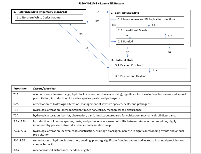
Transition T1A
State 1 to 2
wind erosion, climate change, hydrological alteration (beaver activity), significant increase in flooding events and annual precipitation, introduction of invasive species, pests, and pathogens
Transition T1B
State 1 to 3
hydrologic alteration (anthropogenic), timber harvesting, mechanical soil disturbance
Restoration pathway R2A
State 2 to 1
remediation of hydrologic alteration, management of invasive species, pests, and pathogens
| Obstruction Removal |
|
| Restoration and Management of Natural Ecosystems |
|
| Native Plant Community Restoration and Management |
|
| Invasive Plant Species Control |
|
Transition T2A
State 2 to 3
remediation of hydrologic alteration, significant flooding events and increase in annual precipitation, compacted soil
Restoration pathway R3A
State 3 to 1
remediation of hydrologic alteration, seeding, planting, significant flooding events and increase in annual precipitation, compacted soil
Restoration pathway R3B
State 3 to 2
remediation of hydrologic alteration, seeding, planting, significant flooding events and increase in annual precipitation, compacted soil